Command of the Week - Offset (Week 6)
 Monsen
Administrator 🖼️ 82 images Cartographer
Index
- List (Basic)
- Symbols Along (Intermediate)
- Fractalise (Intermediate)
- Edit Text (Basic)
- Link with Map/File (Intermediate)
- Offset (Intermediate)
- Measuring Tools (Basic)
- Change like draw tool (Basic)
- Modifiers (Intermediate)
- File Paths (Intermediate)
- Complex Shapes [Combine Path] (Intermediate)
- Complex Shapes [Multipoly] (Intermediate)
- Break (Intermediate)
- Map Notes (Basic)
- Coordinates (Intermediate)
- Macros (Advanced)
- Search Files for Text (Basic)
- Text Justification (Basic)
- Mirrored Polygons (Intermediate)
- Managing Drawing Tools (Intermediate)
- Named Views (Basic)
- Symbol Lookup Sheets (Intermediate)
- Symbol Catalog Settings (Advanced)
- Symbol Catalog Filters (Advanced)
- Symbol Control Points (Advanced)
- Define Symbol (Intermediate)
- Curves (Basic)
- Selections (Intermediate)
- Sort Symbols in Map (Basic)
- Extract Properties (Basic)
- Convert File (Basic)
- Get Extents (Advanced)
- Quick Move (Basic)
- Menu Editing (Advanced)
- Trace (Basic)
- Array Copy (Intermediate)
- Explode (Basic)
- Clipboard Copy (Basic)
- Rename & Reorder (Intermediate)
- Drawtools Edit (Basic)
- Trims (Basic)
- Symbol Attributes (Intermediate)
- Fill Style Selection Mask (Basic)
- Browse Files (Basic)
- Node Editing (Intermediate)
- Automatic Sheet Selection (Basic)
- Scale (Basic)
- Text along a Curve (Basic)
- Shaded Polygons (Intermediate)
- Fill with Symbols (Intermediate)
- Global Sun (Basic)
- Symbols in Area (Intermediate)
This series is called the command of the week, but it could also explain a feature. The explanations will tend to explain the technical parts of the command, and is intended to highlight the basics (and complexities) of the command, and information about how to use it, but won't be a detailed tutorial. It is up to you to use it creatively in your maps.
Week 6 - Offset
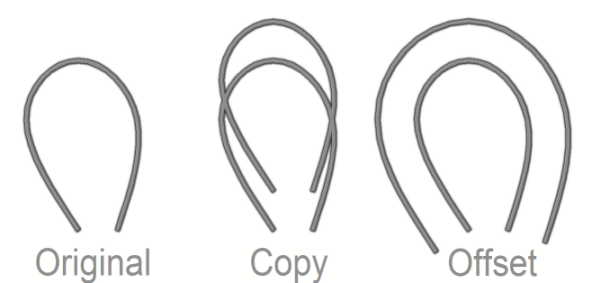
There are several reasons why you may need to have two or more lines running in parallel, such as the tracks of a railway. This is easy for straight lines, because you can simply copy them, but once the lines get the least bit curved, copy won't do, which can easily be seen from my example images below. Fortunately, CC3+ also contains the Offset command, which can create an offset copy of an existing path or polygon.Where to find it?
Menu: Draw -> OffsetCommand Line: OFFSETD / OFFSETCH / OFFSET1 / OFFSETCPY
How to use it?
There are three different versions of this command.- Offset One: This creates an offset of a single path, using the current drawing properties. This means that you can use this to create an offset in a different style than the original.
- Offset Chain: This will create an offset from a chain of entities, using the current drawing properties
- Offset Copy: This will create an offset from the selected entity, using the same properties (color, fill style, layer, etc) as that entity.
When you first activate the command, it will ask for a distance. You can either type this in on the command line, or click two points in the map to define the distance (These click can be anywhere in the map, CC3+ just want a distance, not a location). For precise distances, you'll probably want to use the modifiers (like endpoint) on existing entities in the map to get the same distance, or if you know the distance you need, it is best to just type it in.
Then, it will ask for an entity (or chain entity). Now, select the entity you want to make an offset from. For a chain entity, CC3+ considers entities to be chained if they share endpoints. usually this is accomplished by using the endpoint modifier to start the second entity just where the first one ends when originally drawing them. During this process, you only need to click on one entity in the chain.
For the last step, it asks you which side of the entity to place the offset on. Simply click on the appropriate side of the entity.
Now, the offset might not be visible immediately. If this is the case, simply hit Redraw (Ctrl+R) and it should appear (Unless current drawing properties would cause it to appear under something else, if so, check your sheets)

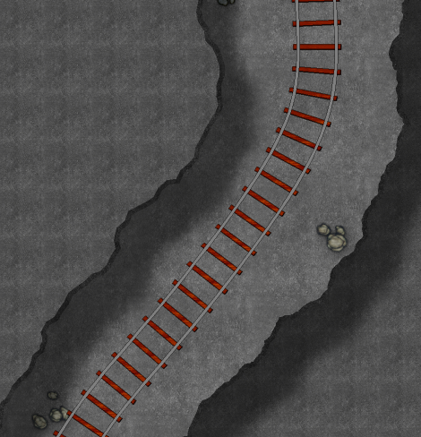
A very good way to make railroad tracks for detail views, like battle maps, is to use the offset command to ensure that the rails are perfectly parallel. Then, you can use another command, like Symbols Along (From Week 2, see link at the top right) to place sleepers along the line (I used a third offset line in between the other two as a construction line for this).


Comments