

Command of the Week - List (Week 1)
 Monsen
Administrator 🖼️ 82 images Cartographer
Monsen
Administrator 🖼️ 82 images Cartographer
Index
- List (Basic)
- Symbols Along (Intermediate)
- Fractalise (Intermediate)
- Edit Text (Basic)
- Link with Map/File (Intermediate)
- Offset (Intermediate)
- Measuring Tools (Basic)
- Change like draw tool (Basic)
- Modifiers (Intermediate)
- File Paths (Intermediate)
- Complex Shapes [Combine Path] (Intermediate)
- Complex Shapes [Multipoly] (Intermediate)
- Break (Intermediate)
- Map Notes (Basic)
- Coordinates (Intermediate)
- Macros (Advanced)
- Search Files for Text (Basic)
- Text Justification (Basic)
- Mirrored Polygons (Intermediate)
- Managing Drawing Tools (Intermediate)
- Named Views (Basic)
- Symbol Lookup Sheets (Intermediate)
- Symbol Catalog Settings (Advanced)
- Symbol Catalog Filters (Advanced)
- Symbol Control Points (Advanced)
- Define Symbol (Intermediate)
- Curves (Basic)
- Selections (Intermediate)
- Sort Symbols in Map (Basic)
- Extract Properties (Basic)
- Convert File (Basic)
- Get Extents (Advanced)
- Quick Move (Basic)
- Menu Editing (Advanced)
- Trace (Basic)
- Array Copy (Intermediate)
- Explode (Basic)
- Clipboard Copy (Basic)
- Rename & Reorder (Intermediate)
- Drawtools Edit (Basic)
- Trims (Basic)
- Symbol Attributes (Intermediate)
- Fill Style Selection Mask (Basic)
- Browse Files (Basic)
- Node Editing (Intermediate)
- Automatic Sheet Selection (Basic)
- Scale (Basic)
- Text along a Curve (Basic)
- Shaded Polygons (Intermediate)
- Fill with Symbols (Intermediate)
- Global Sun (Basic)
- Symbols in Area (Intermediate)
This series is called the command of the week, but it could also explain a feature. The explanations will tend to explain the technical parts of the command, and is intended to highlight the basics (and complexities) of the command, and information about how to use it, but won't be a detailed tutorial. It is up to you to use it creatively in your maps.
Week 1 - List
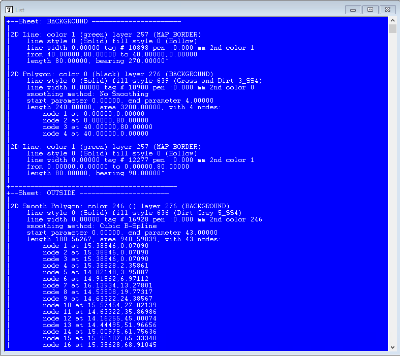
A very common scenario for newer users is that entities seems to overlap in the wrong order, disappear on a redraw, doesn't have the correct effect applied to it, and other problems related to entities simply not behaving as you want them to. Sometimes you also need to know which color an entity is, what layer it is on or what its ID is. All this information is usually very helpful when using advanced selection criteria to pick out a single entity from a stack when you have problems selecting only one of them by using the mouse to make the selection.The best way to get all of this information is through the List command. This is a very simple and basic command, but one that is highly useful to both beginners and advanced users. I start with this command because it is one of the basic commands everyone should know.
Where to find it?
Menu: Info -> ListCommand Line: LIST

How to use it?
List is a command that works on entities in your map. Immediately upon activating it, CC3+ will ask you to select the entities you need information on, using the regular CC3+ selection techniques.Remember that you can select something you cannot see. For example, if your lake disappeared behind your landmass, you can still select it by drawing a selection rectangle in the appropriate place.
Once you finish your selection CC3+ will pop up a separate window with a lot of information about your entities.
How to use this information?
This won't be an exhaustive list, but here are a few common cases:Sheet: By learning what sheet an entity is located on, you can easily troubleshoot ordering issues. Usually, the reason one entity disappears below another is because of the sheet order. By finding out which sheet an entity is on, you can figure out if you need to move the entity to another sheet, or maybe adjust the sheet order itself. By learning which sheet an entity is on, you also knows which effects should be applied to it; a common reason for effects not being applied to an entity is because it is not on the sheet you expected it to be on.
Groups and multipolies: An entity that is part of a multiply or a group might often behave a bit differently in some cases.
Entity Type: Each element in the listing starts with the type of the entity. This is helpful to diagnose odd behavior. For example, an Arc and a smooth path may look similar in the map, but their behavior is very different.
Entity Properties: All entities have a list of properties, like color, layer, fill style, line style. These are very helpful when making advanced selections, but they can also be used to figure out why an entity doesn't look like it should. One hint here is that an entity will only take on the listed color if the fill style is set to solid (and some others), if the fill style is a bitmap instead, the color is ignored, and can actually be used to group entities for selection purposes
Entity tag: The tag is a unique identifier for each entity. This is helpful to know when you have entities that are difficult to select because of many similar overlapping entities.
Node list: Most polygons will have a node list. These basically defines the shape of the polygon, and can be manipulated with node edit.
Other information: This really depend on the entity type, but typically, you will find information about the length of paths, of the area polygons cover, of the placement and scaling of symbols, and so on.
Once you learn to read the output from this command, it is an extremely helpful tool in your mapmaking.
Comments
Thanks, Monsen.
@ Remy - I know how you only recently cleared up the number of stickies at the top of the forum, but do you think this should really be kept there along with them. Its going to save an awful lot of time for newbies