


Wyvern
Wyvern
About
- Username
- Wyvern
- Joined
- Visits
- 3,302
- Last Active
- Roles
- Member
- Points
- 5,647
- Rank
- Cartographer
- Badges
- 24
Latest Images


-
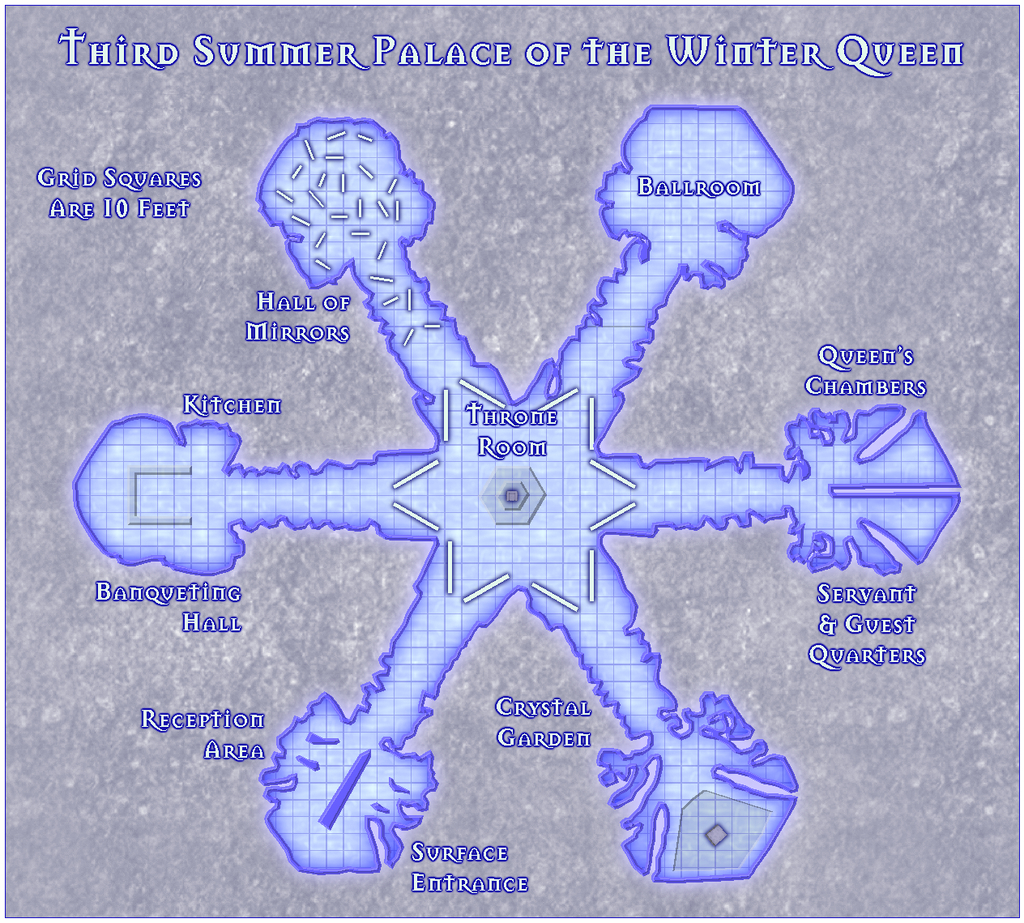
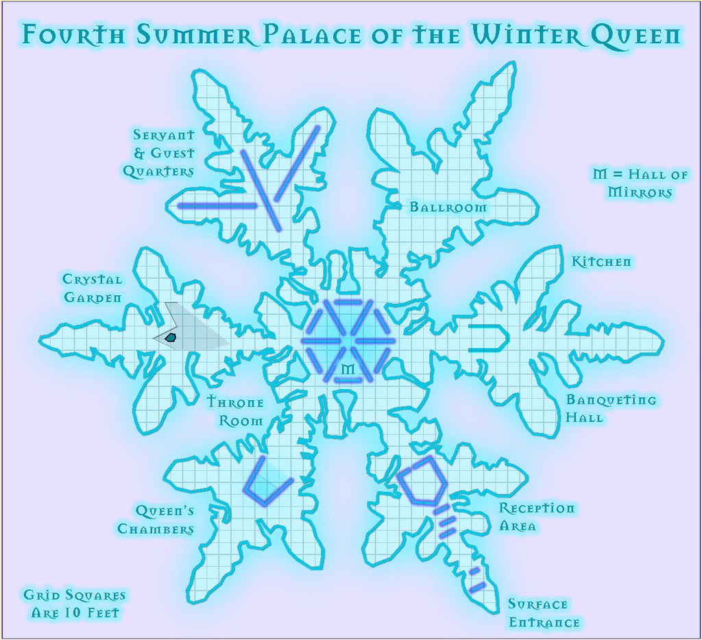
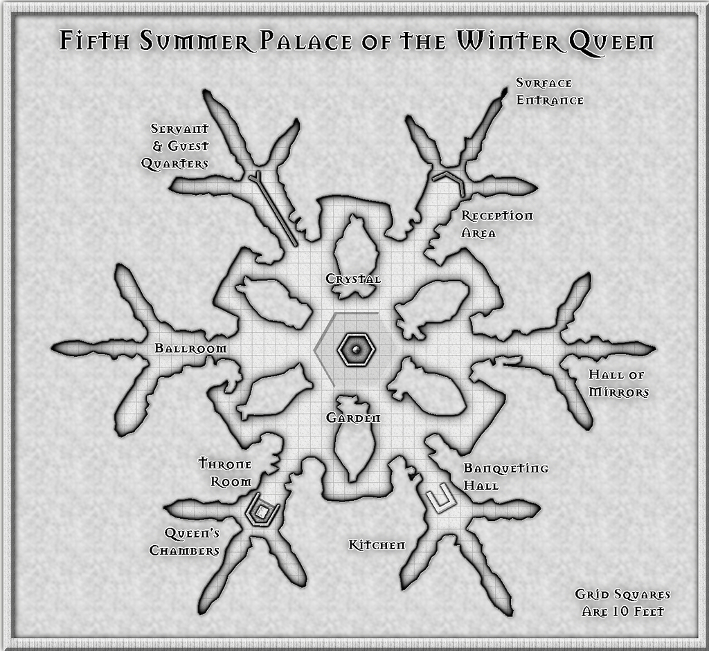
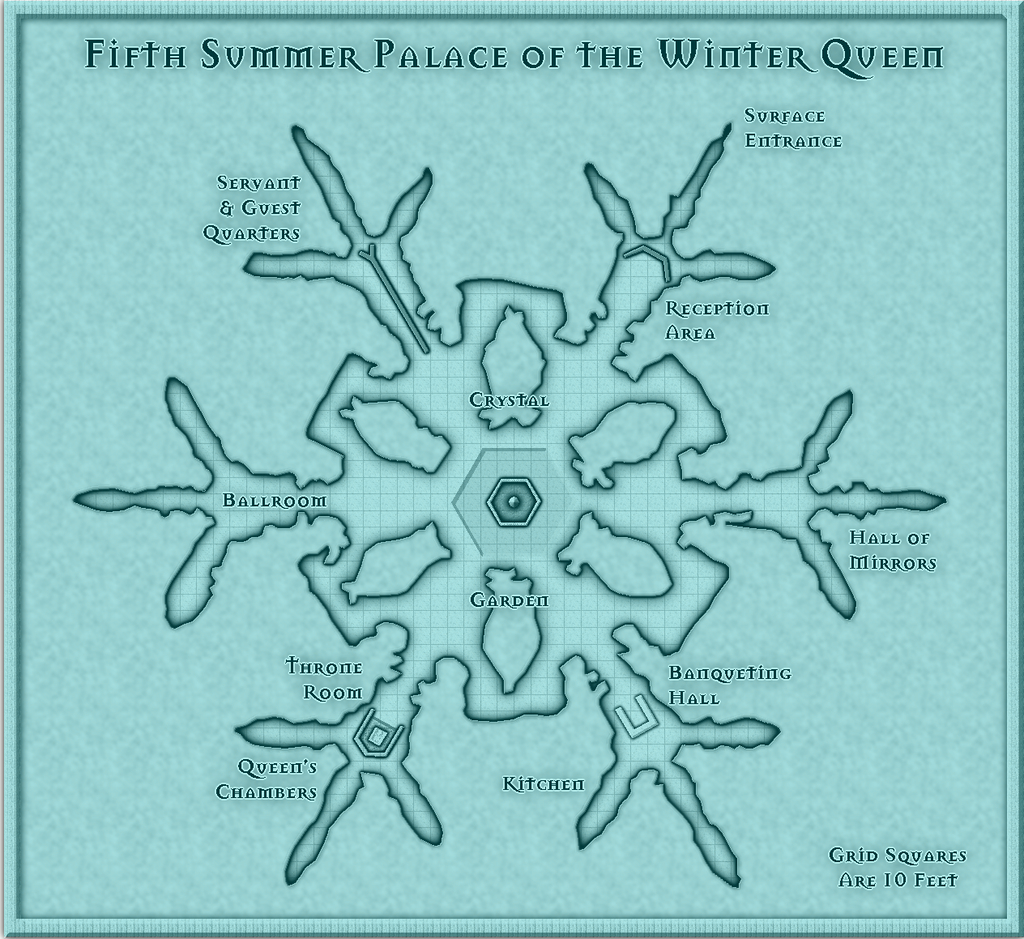
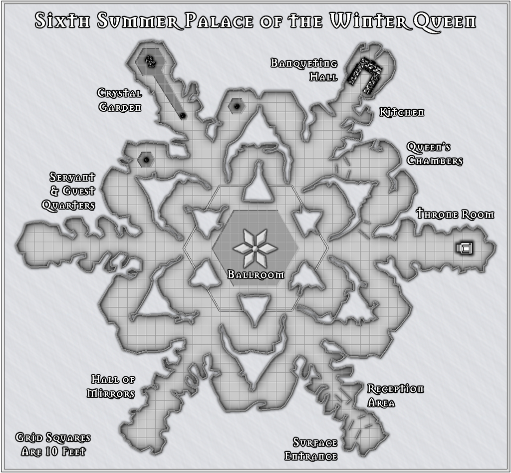
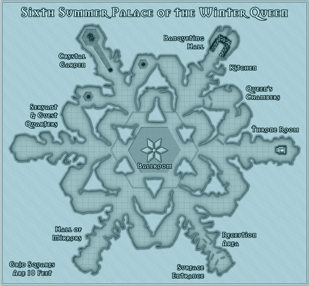
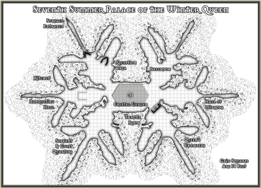
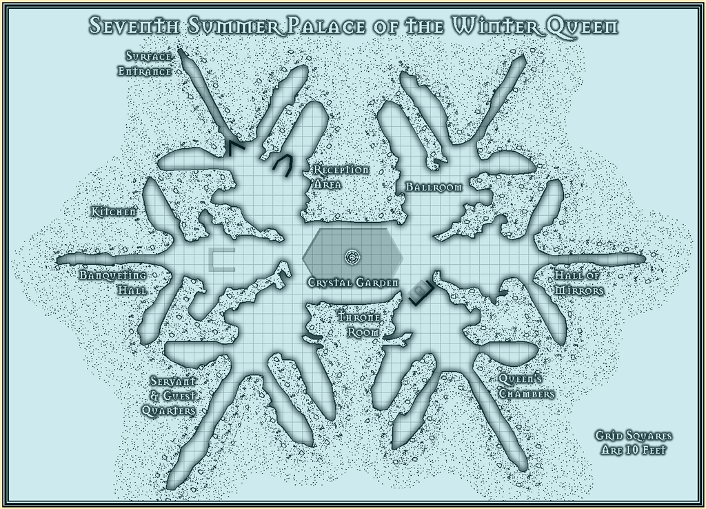
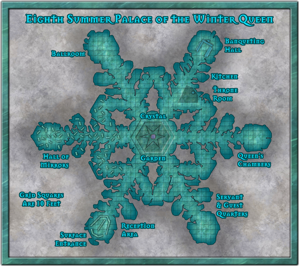
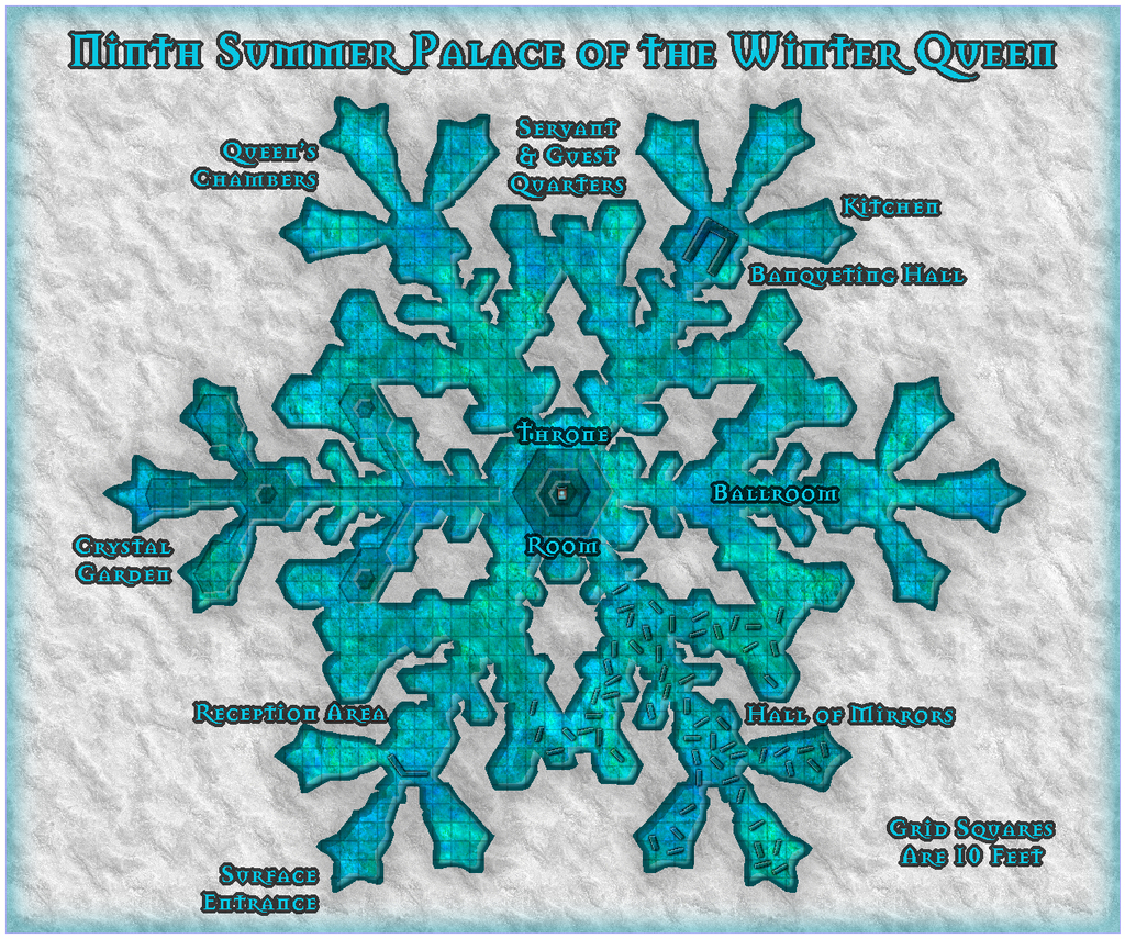
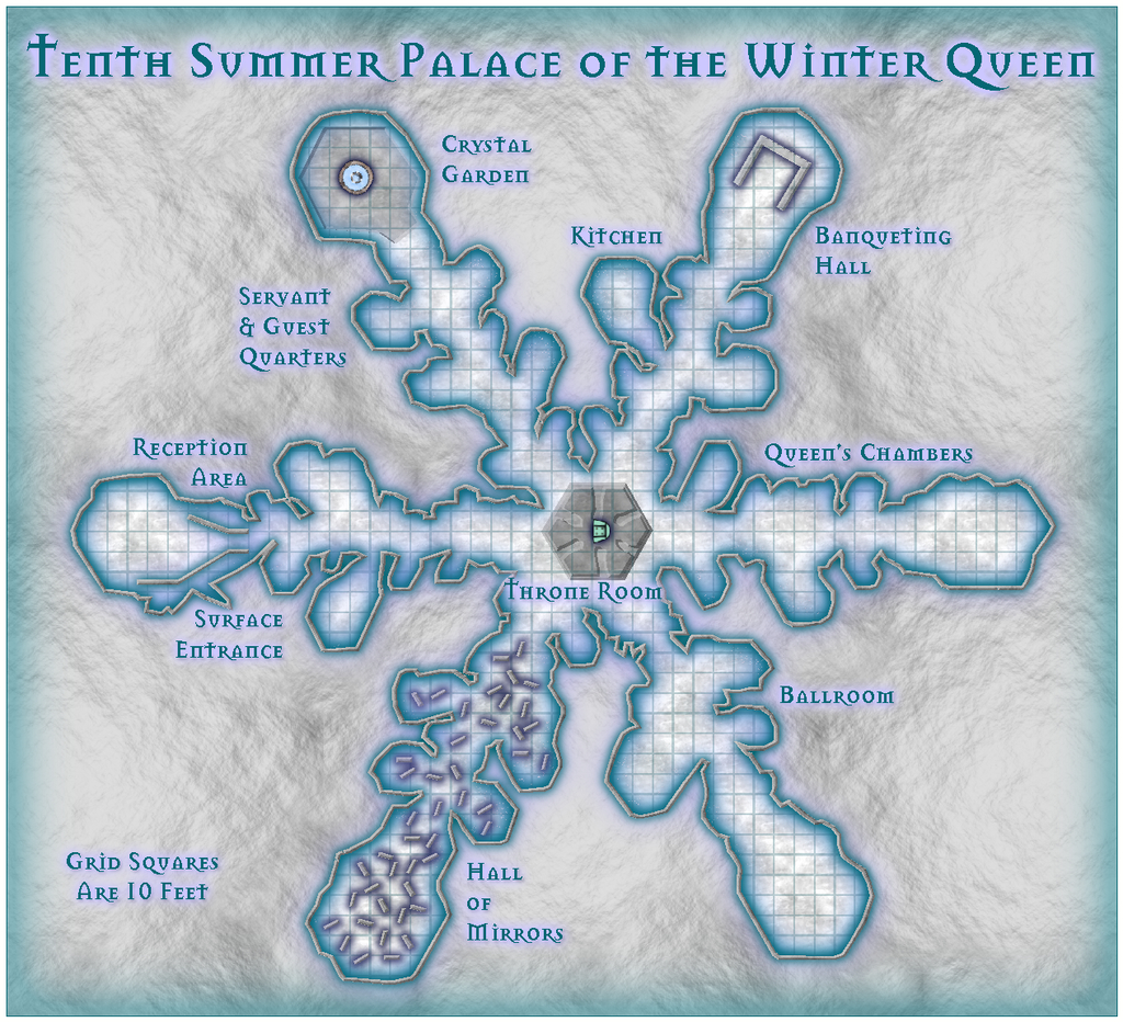
Community Atlas 500th map and 4 year anniversary competition with prizes.
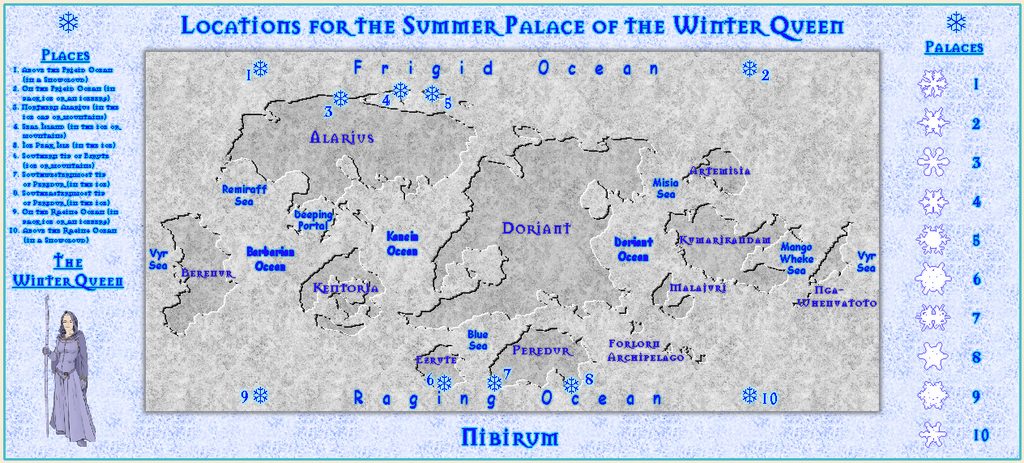
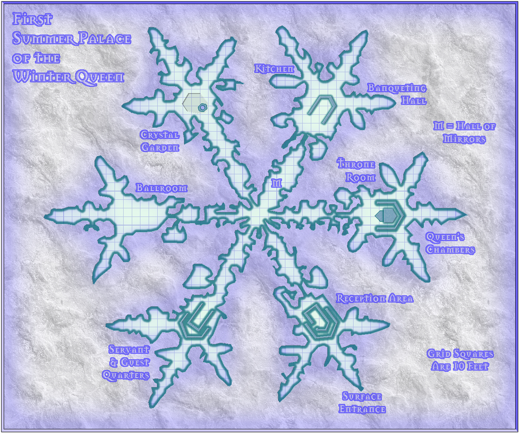
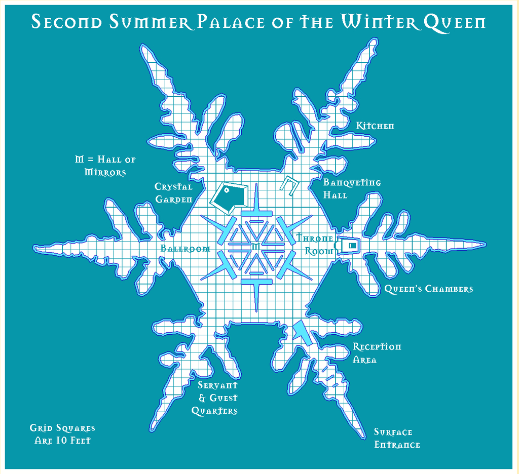
So, here are my submissions for this 500th map and anniversary contest, The Summer Palace of the Winter Queen. For the contest, these should be considered as a single entry, incidentally; I'm not trying to "stuff the ballot box" with a multiple series of maps here ?!
There's a WIP thread elsewhere on the Forum which gives more details on this set, and the construction process in places, and if all goes to plan, I should be adding higher-res versions of all twelve maps to the Gallery once I've finished this post here. Never done that before, however, so we shall see!
As there is an additional pair of detailing note files to accompany these maps for their final Atlas versions, as well as the usual Atlas submission notes to provide for Remy, I'll send the full set of FCWs, PDF and text files to @Monsen as a separate private e-mail. The FCW files are though included below, following the rules of this contest.
Note that Palaces 5, 6 & 7 come in two versions, the vanilla B&W ones and those with a blue screen superimposed.
Whew!?

![[Deleted User]](https://secure.gravatar.com/avatar/c75d9a245b74d9c59be0999ea81ca541/?default=https%3A%2F%2Fvanillicon.com%2F92add7f8c954488718110edc4896ad39_200.png&rating=g&size=200)


 and 2 others.
 -
Blackmarsh - Another Handdrawn Fantasy Map
As mentioned elsewhere on the Forum, I've again been mapping with this new style recently. So here it is, Blackmarsh (higher-res version in my Gallery):
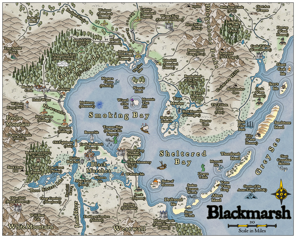
Like the previous Wyvern's Wood map, this isn't intended for the Atlas, since as those familiar with RPG settings may realise, this is actually my own redrawing of the map from the free PDF of the Blackmarsh setting, published by Bat In The Attic Games, and available here on DriveThru RPG.
I've had a soft spot for this for some years (I mean, c'mon, it has undersea features as well as those on land!), as it's heavily based on the old Judges Guild "Wilderlands" maps and settings from the late 1970s. That's not surprising, because Blackmarsh's author, and owner of Bat In The Attic Games, Robert S. Conley, knew and worked with one of the two founders of Judges Guild, Bob Bledsaw (Snr), and until a few years ago, had his own published updated versions of those old Wilderlands settings and maps available also on DriveThru. The fact they're no longer available came about for reasons those familiar with the sad history of Judges Guild after Mr Bledsaw died, will need, nor wish for, any reminders. Those unfamiliar are perhaps better off in that happy state of ignorance.
I've had a print-on-demand version of Blackmarsh for some years, following a Kickstarter run by Bat In The Attic. While I've tinkered around with the setting a little since, I've been prompted to actually compile a proper new map for it now, with some of my own tweaks, because Robert Conley is currently running a fresh Kickstarter for the Northern Marches setting, from his own Majestic Fantasy Realms world. This Blackmarsh area is just one small part of that whole. For anyone interested, it's easy enough to find on Kickstarter without a link here, and the project runs till June 28th this year. It's already doing very well, and for those keen on the older style of simpler setting descriptions and maps (though these latter are more sophisticated than the old Judges Guild style - and they're in colour!), it could well be worth a look. While the original had only hex-maps, I felt this hand-drawn style seemed ideal for this translation.
If you want to find out more about Blackmarsh, the free PDF is the place to go, since all the mapped locations are described there, and you can then discover what the great significance is of that Mountain That Fell...


 and 5 others.
 -
A Hand-Drawn Fantasy Map of Jack Vance's Dying Earth
Having seen several Forum topics in recent months regarding the creation, and recreation, of maps from various past fantasy settings, both literary and in role-playing games, and despite having several ongoing mapping projects for the Nibirum Community Atlas, I've lately become distracted into trying a map of the Dying Earth, based on the fiction of Jack Vance that used this setting. Vance's Dying Earth writings were one main fantasy influence on the original Dungeons & Dragons RPG, and they continue to resonate in numerous other games now.
In approaching it, there's the complication that there are no definitive maps created or authorised by the original author himself for the complete world he created, and the story descriptions are sometimes vague enough to make constructing one tricky. Prior to the post-pandemic period, there'd been probably no more than five attempts, all of which show sometimes considerable variations between one another, and sometimes split between different maps. This post on the Lost Delights blog from 2020 discusses the five, with image links.
Over and since the pandemic, there has been one more, by Doug Kovacs, created specially for the boxed set for the Dungeon Crawl Classics RPG by Goodman Games, following their hugely successful Kickstarter campaign to produce a Dying Earth setting for the DCC rules in 2021. There are some images of the map on the Goodman Games store page for the boxed set. Even so, despite this being perhaps the most colourfully lively and more nearly complete of all the maps, the vagaries of the tales mean all such attempts are based on personal interpretations, and thus none are truly definitive.
I'd had my own vague notions of trying to map the Dying Earth, going back more than 40 years to when I first read the stories, deterred previously by that vagueness. Having recently managed to secure a copy of the DCC boxed set though, I thought it might be fun to try to redraw the Kovacs map (and maybe some of the others later) as a CC3+ version. Hence this topic.
For those unfamiliar with the setting, it is in Earth's 21st Aeon (an unimaginably vast time ahead of our own). The following is a snapshot provided in one of the earliest tales, "T'sais", first published in 1950 in "The Dying Earth" anthology of six stories. "T'sais" is the third of the six. Pandelume, a near-god-like mathematician-magician, whose form must never be seen as it would cause utter madness, speaks:
""Earth," mused Pandelume. "A dim place, ancient beyond knowledge. Once it was a tall world of cloudy mountains and bright rivers, and the sun was a white blazing ball. Ages of rain and wind have beaten and rounded the granite, and the sun is feeble and red. The continents have sunk and risen. A million cities have lifted towers, have fallen to dust. In place of the old peoples a few thousand strange souls live. There is evil on Earth, evil distilled by time… Earth is dying and in its twilight…""
Add to that that the Moon is long gone, stars in the night sky are very few, that the world is filled with marvels and dangers both magical and technological (there is no difference between them) and has been visited by creatures and beings from what were once distant stars and galaxies, all too now largely long gone and forgotten, and you start to get an impression of where we are!
So, preamble done. Now to the mapping. I chose Ralf's Hand-Drawn Fantasy overland style, as it had worked very well for my attempt at redrawing the Blackmarsh partial world map previously, and this was going to be a similar project. The first complication was there's no scale on the Kovacs map (or indeed, on most of the others), largely thanks to the vagueness in the tales. So I simply went with an approximation of the ratio, and doubled the normal map area to 2000 by 1600 mapping units. Dropped-in a copy of the Kovacs map to trace on the normal BITMAP Layer and Sheet, and started drawing. This is an early screenshot:
It was taken some way in to the mapping, as I'd had a couple of false starts by this point. At one stage, I'd thought it might be possible to split the main landmass in two along the line of that curious river that apparently connects the northern and southern oceans, but it proved much too tricky to get the river width to look right. Given that this style uses the Color Key effect to cut through the land to the sea, that wasn't really necessary anyway.
Most of what's visible here is a test, to see what works and what doesn't, and the odd-looking, truncated river lines will be tidied-up as mapping proceeds. It has been strange to stick with the default Effects settings that use the Percent of Drawing Extents Width here, which I'd ordinarily swap-out for Map Units instead, but as they work very nicely at this level of viewing, all seems well.
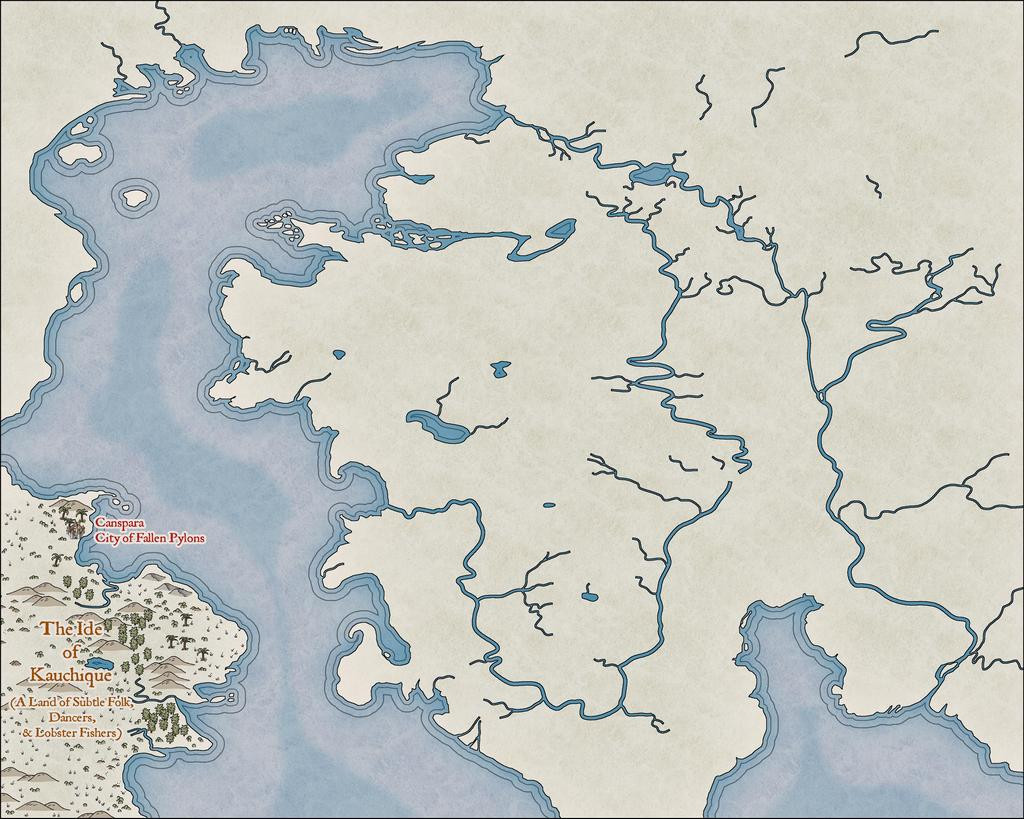
The next image shows how the river lines are going to be tweaked, added-to and adapted along the way, just in that Kauchique quadrant for now:
Other adjustments have been made too, in changing the deeper sea contours, and such processes are liable to recur frequently as the journey proceeds, given this is not going to be a rapid process, because of the detailing involved.
Somewhat strangely, I found I was adding the map detail much as if it were hand-drawn in reality, from left to right:
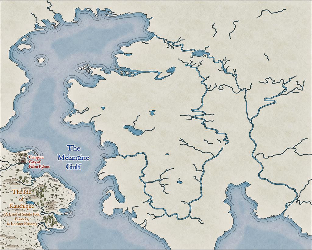
As each of these snapshots shows the progress from an individual mapping session, it took several days to get to this stage:
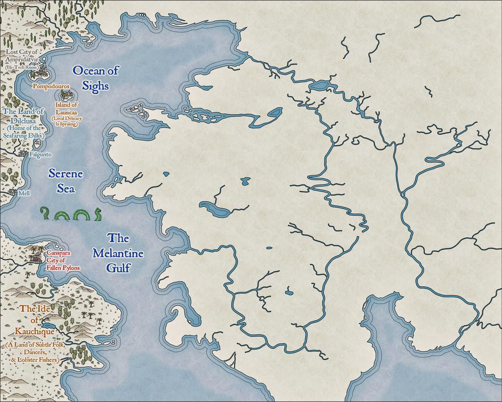
Which is where things are currently; clearly, with lots more still to do!


 and 2 others.
 -
Community Atlas: Kara's Vale, Ethra, Doriant
Returning to Doriant for my next Atlas maps, this time I was heading for somewhere on Ethra, the huge island in the great, almost-landlocked, southwestern sea there:
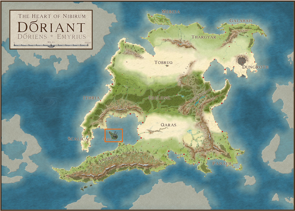
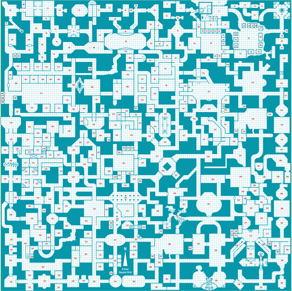
Examining the notes for Ethra indicated the island was split into a series of provinces, although much of those descriptions centred only on the major settlements, so it seemed there'd be plenty of options to slide-in a small dungeon map somewhere unobtrusively, even when surrounded by one of the typical 20-mile-square area maps I've favoured for much of this project. The Inkwell dice-map dungeon layout had already sparked vague thoughts of something alchemical, so a quiet spot might be useful, and while there are plenty of such potential places in the vast, volcanic barrens on Ethra, my eye kept being drawn to a small, labelled area, Kara's Vale;
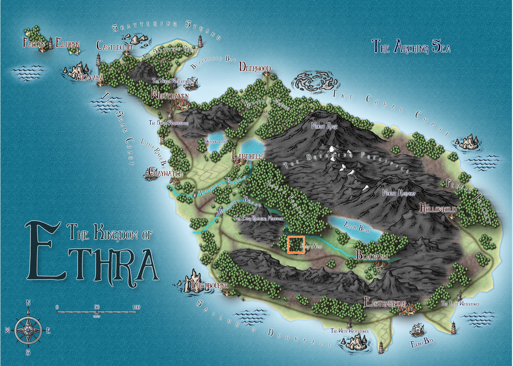
The way this area was mapped intrigued, as the Vale's woodland looked to be sunken compared with the woods to either side, yet had no major river shown flowing through it. With the volcanic nature of the whole island, this made me think of a small rift valley, so that's what it became:
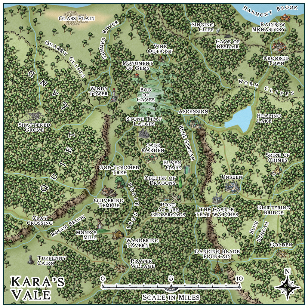
In an effort to persist with using linked mapping styles for this area, I decided on the Mike Schley styles (SS4 for the dungeon and the surface entrance site), something I've not really used much for overland mapping before. While the original Ethra maps showed deciduous and conifer woodland symbols, because the site is in the tropics, around 23°S latitude, here I went with "jungle" style trees instead. As I wanted to suggest higher plateaus to either side of the Vale, there was a bit of a battle to show the north-facing cliffs, as such options aren't available in this style, so I had to use the normal cliffs, and then hide everything except the upper parts with a suitable land-textured mat, something adding a second, lower, cliffline in the northeastern corner, greatly complicated! However, the jungle helps hide most things, one way or another...
The general map design was set by how the shadowed valley and unshadowed woods were shown on the Ethra map, and where the major river, just on the northern edge here, lay, while the specific features were all placed randomly, using my usual grid and dice method, with a one-mile grid spacing. What those places were was determined using or interpreting cards from various prompt decks produced by The Story Engine, a little like last time's for the Selenos maps in Artemisia, except this time also drawing from their "Deck of Worlds" as well as the "Loremaster's Deck" main sets, plus the "Worlds of Myth & Magic", "Loremastery" and "World & Lore Bridge" expansion sets. That's where pretty well all the on-map names came from too.
Map notes expanding on some of the place-names, again largely based on what the cards came up with, will be in the final Atlas version of the map, and also much as last time, the cards inspired thoughts and details beyond what I'd expected, which of course is their whole point. As for where the dungeon layout might be placed, there wasn't a shortage of possibilities. Ultimately, Windy Tower, northwest of the map's centre, won out, as we'll see next time.


 and 1 other.
 -
Community Atlas: Dendorlig Hall - A Sort-Of D23 Dungeon for Nibirum
Those of you who follow the RPG world online will be aware already that all kinds of hell have been breaking loose in recent days, regarding the curious acronym "OGL" and its current and future uses. Those unaware of, or disinterested in, the RPG world - you're very fortunate; DO NOT get involved in this morass!
Consequently, a distraction was obviously in order. So I distracted myself away from my latest Errynor map (not sure that was intentional, however!), and was thinking about another recent suggestion from the online RPG world, with the equally curious acronym "D23". Essentially, the original idea behind this, which I think loosely expands to mean "Dungeon 2023", was to set a personal challenge for anyone interested to design a dungeon room a day throughout 2023, to end up with a 365-room megadungeon for those lasting the course.
As you may imagine, people have approached this with varying degrees of optimism, since trying to persist with this for an entire year is quite an undertaking, particularly given how unpredictable the broader events affecting everyone have been in recent years. Quite a number of folks seem to be giving it a trial-run during January, followed by a "we'll see..." beyond that.
Being no stranger to long-term projects, unfortunately, I learnt about this only on Dec 31st last year, which was a bit late to start planning anything! Several ideas have been mulled over since then though, a couple of which might be of interest to some people here looking for a less challenging way to participate in this project - maybe a small dungeon level a month, say, perhaps using one of the free online random dungeon designer systems to generate suitable base maps, or possibly one or more dungeons containing each a dozen rooms. These could be for contribution to the Community Atlas during the year, though some might need an outdoor area map preparing as well, depending on exactly where they'd be located. I'm sure some of our more active area mappers like Quenten and JimP could suggest some potential locations, for instance, if you can't find somewhere satisfactory yourself.
While this list won't be complete, these are the random dungeon generators I've become familiar with in recent times. I'm sure others here can suggest alternatives:
https://donjon.bin.sh/d20/dungeon/
https://watabou.itch.io/one-page-dungeon
https://www.d20srd.org/d20/dungeon/
https://osricrpg.com/tools/index.php
This latter site, also known as the "Robe of Useful Items", includes the old Wizardawn content as part of it. Wizardawn, as I've mentioned on the Forum before, is no longer available live online. Instead the OSRIC RPG site has a link letting you download an HTML version of the complete old site, which still works in a browser under Win 10 (at least - not sure about Win 11), though it is a little clunky to set-up. It contains a vast treasury of "Old School" style RPG features and random generators created by various people over many years, however.
So, what have I done? (Or should that be clasping-head-style, "On no; what have I DONE?!") Well, thus far, I decided a sort-of D23 dungeon for Nibirum wouldn't have 365 rooms, but 360, because of course Nibirum's year is 360 days long. So I generated a suitably-sized random dungeon using the Wizardawn system. This creates the map from a large series of old hand-drawn dungeon geomorphs, so comes out a little rough-and-ready, with the sort of imprecisions you might expect. Which I then traced into CC3+, along the way deciding I wasn't going to remove all those imprecisions, so not all the walls are quite straight, or always parallel to the one opposite, or wholly symmetrical, and so forth.
On that "Old School" basis - although personally, I still can't get away from the idea the style's quite new-fangled really (I come from still further away in time with RPGs, after all!) - I went with the Old School Blue Dungeon style from Cartographer's Annual 12. This is a very forgiving drawing style, and uses no effects, so despite the 700-foot-square size of the random dungeon, it only took a few days to put together, a bit at a time:
This is still work-in-progress, as even at this blurry scale, I'm sure you can spot some elements that need adjusting. I know I can! And if not, I've uploaded a larger version to my Gallery! Plus, I may want to add or amend details in places subsequently, once the content description is finalised. A symbol key will need adding as well, I suspect. Luckily, the Wizardawn set-up generates a vast amount of text data as well as random maps - albeit the description only has the same number of labelled rooms, and isn't fitted to whatever the random dungeon design plan looks like, so it takes some work to knock that into a shape that makes sense. Which may be where the "2023" facet comes in here!
That's all to come, but for now, it would be helpful if someone could point me towards a place on Nibirum where such a substantial dungeon might be situated. I'd thought about adding it to the existing Community Atlas megadungeon there, but as it's a megadungeon in itself already, that seemed counterproductive. Ideally, I'd like to place it somewhere that already has a suitable overland map at a small enough scale to show where a dungeon entrance could be, and while it's not firmly fixed, the original was chosen for "Mountains" as the nearby outdoor terrain during generation. It would be nice too to set it on a continent/landmass on Nibirum I've not mapped in before - so EXCLUDING Alarius, Kentoria, Ezrute and Peredur ideally (this is not a hard-and-fast rule, however).
There is an exterior entrance in a large cave towards the top right of the map (area 1), which has a heavily-walled military keep-like structure (3), and an external wall with a double door (the north wall of 2), and while I'd imagine the entire structure is no longer used by the people who originally constructed it, or not for the purpose it was first intended, at least, that may be something to bear in mind when looking for suitable sites on Nibirum for this to go.
More details to follow, if all goes to plan.


and 1 other.
-
Festive Winter Card Challenge - Ended - Please vote for your favorite
This is my somewhat unexpected entry for this contest; unexpected as when it was announced I was, and indeed remain, deeply involved with the next part of my Nibirum mapping project for the Community Atlas. As explained elsewhere on the Forum though, once you start having ideas it's difficult to escape their implications...
So, here we have Merry Old Christmas Town, sort-of British-style:
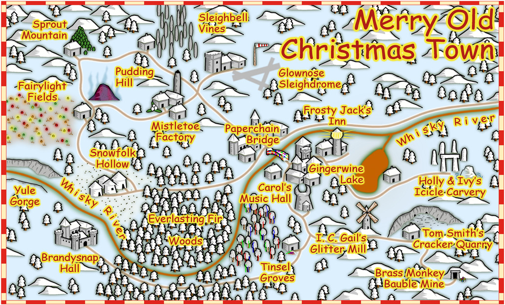
I've added a higher-res version to my Gallery as well, albeit this one's not come out too badly at the usual Forum maximum size, as the style seems to cope quite well with increased anti-aliasing without becoming too large.
Just to clarify, this was prepared using ONLY CC3+; there's been no post-processing of any kind.
Feels slightly weird not to be submitting the map for the Community Atlas as well for once!


 and 4 others.
 -
Lovecraft's Providence
After completing Queen Mica's Scintillant Palace for the Community Atlas, I'd intended to move straight on to the next Errynor 250 x 200 mile map. However, it transpired that Remy was going to be busy with end-of-academic-year items through most of July, so I held-off submitting the Palace maps for a while, and ran into some problems myself. Thus I ended up distracted away from mapping for the Atlas for a time, and somehow found myself concentrating on the city of Providence in Rhode Island, as portrayed in the tales of H. P. Lovecraft from the 1920s and 1930s.
There's an astonishing amount of freely-available information to be found about many places online these days, and a project really just for my own interest in identifying some of the locations mentioned in a couple of Lovecraft's tales, soon grew out of hand rather, as these things do, and it became possible to find more and more seemingly obscure spots on older maps of the city, with information from numerous blogs and websites online, and even two quite recent hardcopy "Annotated Lovecraft" volumes edited by Leslie S. Klinger (formally, "The New Annotated H. P. Lovecraft", 2014, and "The New Annotated H. P. Lovecraft: Beyond Arkham", 2019, both published by the Liveright Publishing Corporation).
Of course, mappers must map, so it wasn't long before I wanted to try drawing some of these findings out in CC3+. After toying with half a dozen possible mapping styles from various of the Cartographer's Annuals, it was perhaps inevitable I would finally select the Cthulhu City style from December 2017, CA132. The choice was complicated by the facts that I needed both a substantial number of rail lines, and some means of indicating the city's topography. While the former don't feature in the Lovecraft stories at all, they're a very dominant presence in the maps from the 1920s and 1930s, although curiously, the Cthulhu City package doesn't have any tools for drawing rail lines (for all there is an illustrative rail station symbol). The topography is, however, a constant presence in both the tales and on the maps - not least as one of the main roads, Meeting Street, is actually broken in one place where the hillside is too steep, the road ends, and transforms in mid-street into a set of steps instead! Again though, "Cthulhu City" offers no assistance in this respect either.
Luckily, both can be accommodated very easily by simple lines of different colours with maps of this general appearance, and as I'd sourced an excellent map from 1935 by the Geological Survey of the US Department of the Interior, which had a complete street and railroad map superimposed on a 10-foot-contour topographic map, that was always going to be my starting place.
To keep things manageable and as clear as possible, the area involved had to be carefully chosen, and a couple of outlying places of potential interest had to be dropped quite soon in the process as impractically distant from the majority of important sites. Finally though, I arrived at:
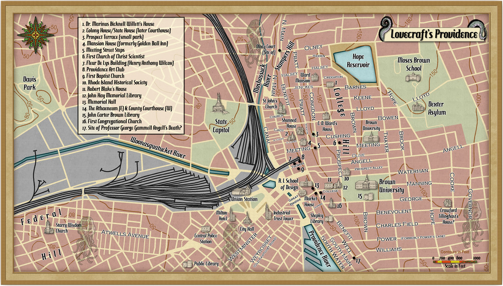
Naturally, this assumes viewers will have a degree of familiarity with the Lovecraft tales in question, namely "The Call of Cthulhu", "The Case of Charles Dexter Ward", "From Beyond", "The Haunter of the Dark" and "The Shunned House", plus one spot which is not derived from Lovecraft, the Milton Hotel in central Providence near City Hall, which came instead from the published "Call of Cthulhu" RPG scenario "The Shadow Over Providence". There's a little more information and commentary in this accompanying PDF though, which may help:
I've also added a higher-res version of the map to my Gallery, and the FCW file is below, should anyone wish to make use of this for their own "Call of Cthulhu" RPG-related activities. It does need the Hamburger Heaven font that comes with CA132, Arial from a standard Windows 10 installation, and the free Copperplate Gothic Light font to view properly:
 and 4 others.
 -
A Hand-Drawn Fantasy Map of Jack Vance's Dying Earth
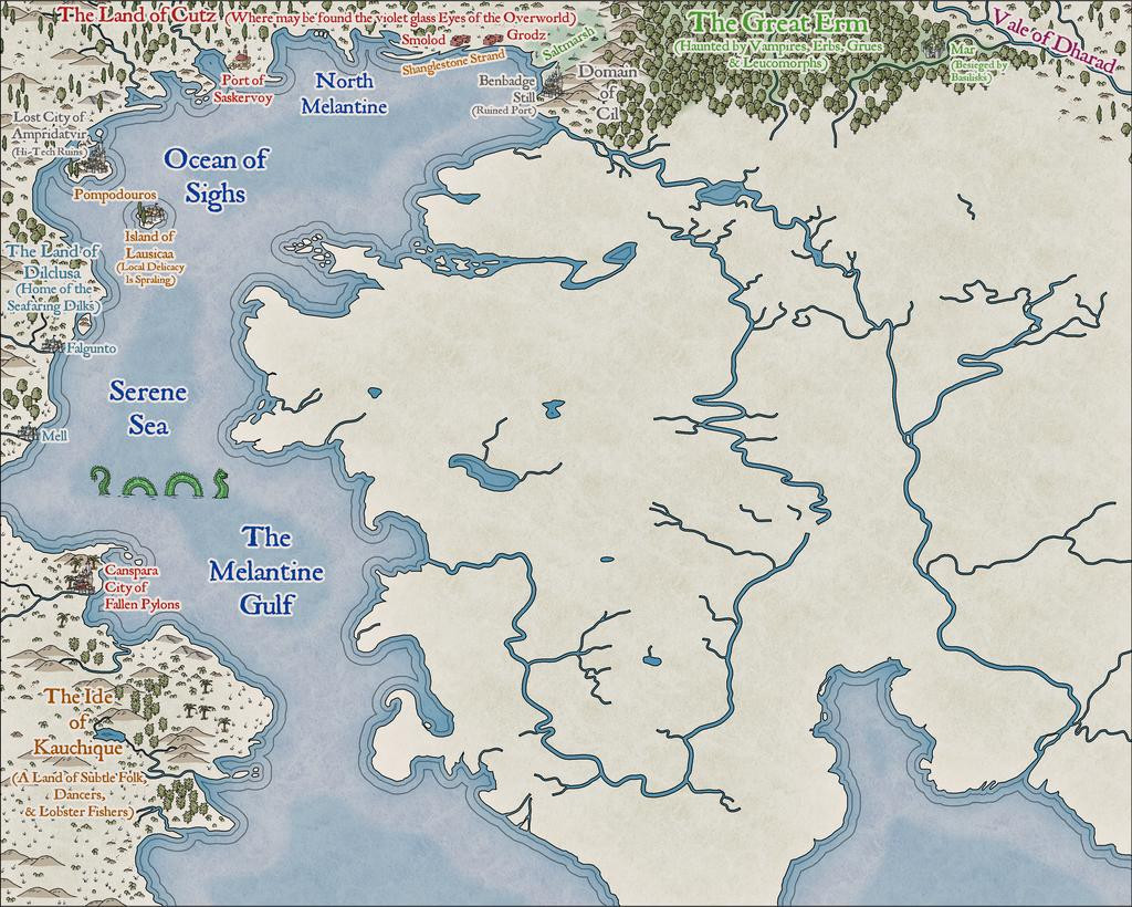
Heading further south in the main landmass area now:
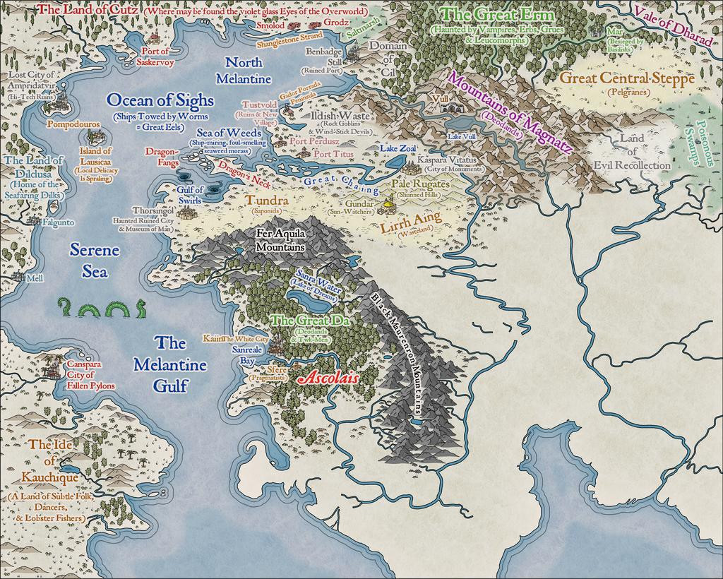
Plus making tweaks to a few labels previously-placed. Every now and then, something just doesn't look right, or something's been forgotten. Or occasionally realising there's more space than was thought before, etc...
Everything here has been placed individually, incidentally, except for some of the areas of wasteland/steppe symbols, where the black outline drawing fill designs were used instead (mostly because few of those outline versions are available as separate symbols too - only the grass and dead trees, in fact). As those fills can look a little sparse, I did a mixture of adding some extra symbols by-hand, and duplicating the filled polygon to a separate sheet, then changing its fill type. There are several sheets for different terrain types in the default style setting, so there's a choice of picking sheets that do or don't have effects on with these - the black outline drawing fills don't usually need the edge fade effect some sheets like the mountain background terrain one has, for instance. As an example, for the Tundra, Lirrh Aing Wastes and Steppe areas, I began by adding a coloured polygon using the Desert Terrain drawing tool, and then just copied that polygon onto two or three more sheets to add the black-line symbol-fills (using separate sheets in case I needed to remove one after its "test fitting").
Down to the map's southern edge next, giving a chance to play with some sand dunes in the unnamed Desert (although I'd already added a few dunes to Kauchique in the early stages, these were more concentrated here). Not to mention sneaking-in a couple more sea creatures:
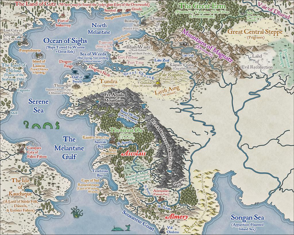
The results of the last session for this update finally sees the label added for perhaps the most evocative of the Dying Earth place-names, The Land of the Falling Wall, where may be found the dark-eyed necrophages and the great Walking Serpents (couldn't quite find space to squeeze in a label saying this, unfortunately, after a couple of failed attempts; at least I'll remember!):
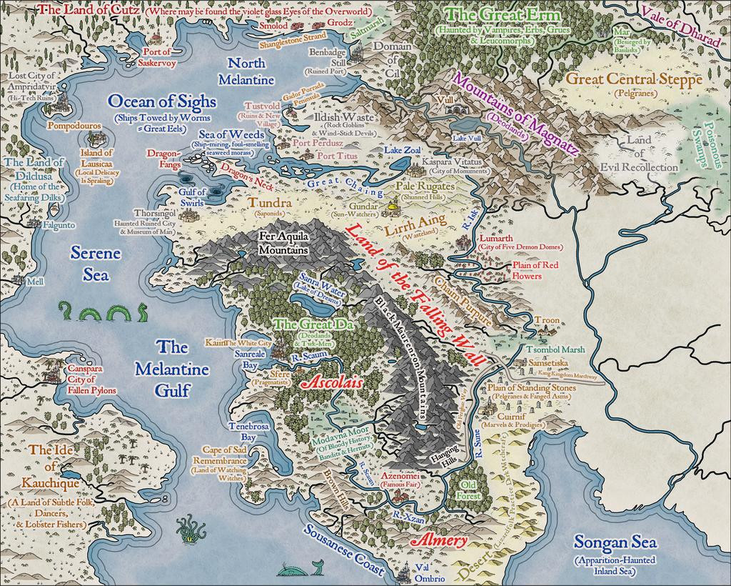
I didn't actually realise until I was typing-up these notes and checking through the images, that for some reason, without having altered the image size or resolution, or changed the map effects, the sea lines just off the coasts are slightly different on this image to all the rest - fractionally thicker and further from the shore-lines. No idea why though! One more mystery of The Land of the Falling Wall, mayhap?
Last segment to complete - needing maybe just another couple of sessions...
-
Wyvern's Wood - A Handdrawn Fantasy Map
Seeing the maps appearing on the Forum using this new style already, it's perhaps unsurprising I've felt the need to join in, as much as anything because the main sample map that comes with the Handdrawn Fantasy Annual style included The Wyvern's Wood!
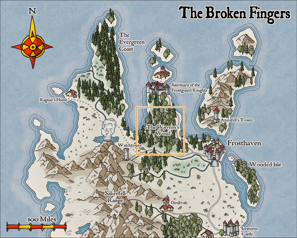
In a break with my usual mapping too, this one isn't intended for the Community Atlas (although it's possible it may eventually feature there, probably in a variant form). That orange outlining square shows the region I picked to illustrate from the sample map.
Having had a long fascination with woodlands for fantasy mapping and scenario designing, I was somewhat spoilt for choice as to which of my previous RPG-related settings to draw upon in creating this map. What I went with was a selection of items from a storyline drafted in 1993. I'd intended it originally as a one-off scenario, run using the Call of Cthulhu rules, for a twice-yearly gaming convention I attended for much of the 1990s. The design though grew into something that needed a longer timescale as a short campaign instead, and ultimately, it was never run at all.
That scenario was a modern-day one, set initially on Bodmin Moor in Cornwall, England, and which included various loosely Arthurian and mythological items, then increasingly introducing horror and surreal elements, rising to a chaotic finale. What I've extracted from it here are specific significant locations, adding them to the new map in no strong order, since the originals were designed to be encountered in only a rough order anyway - and in some cases repeatedly. Most of that detail and pathway structure has naturally been omitted here.
So this is what I came up with:
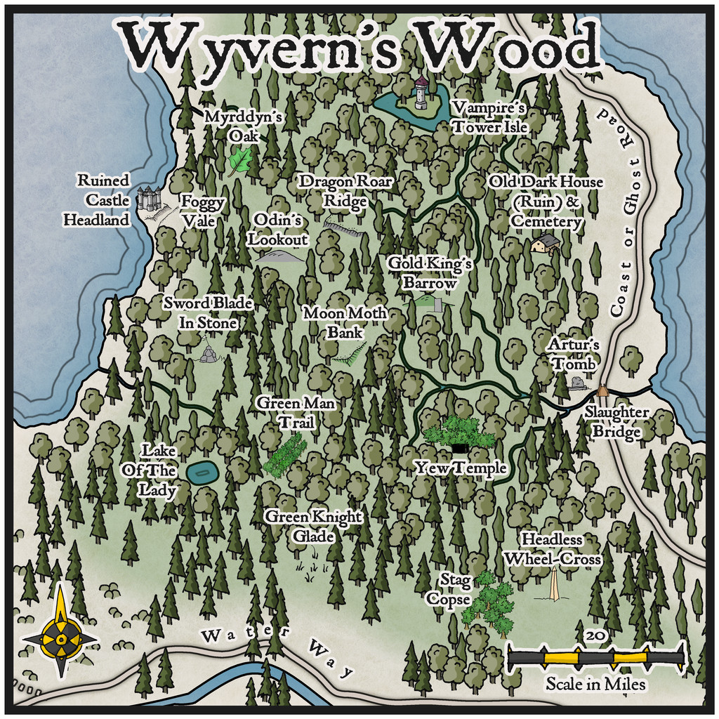
As is obvious though, I had to draw on other handdrawn styles from SS1 in identifying the various features, to highlight them sufficiently, and their sizing is of course hopelessly out of scale, as so often happens with this kind of pictorial map. Maybe though some of these added symbols might give some ideas for future expansions of the new style!

 and 1 other.
 -
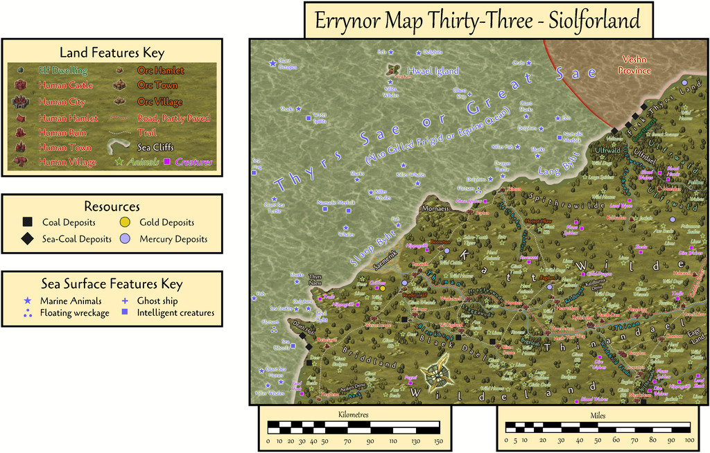
Community Atlas: Errynor Map 33 - Siolforland
The next map in the set of 250 x 200 mile areas from "my" corner of Alarius is now ready for the Atlas. It's the one in the lowest left corner of the Errynor region, Map 33:
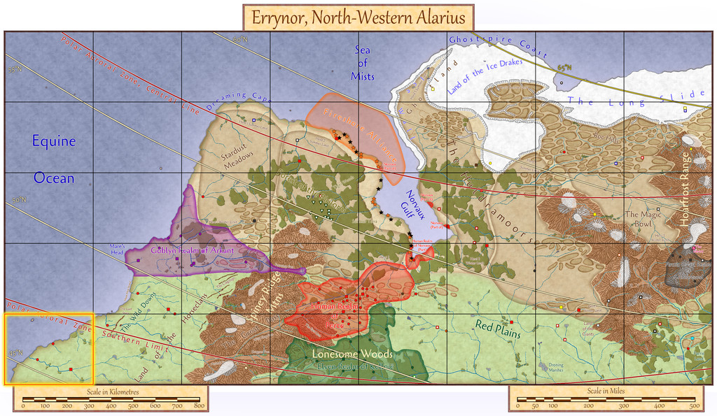
This map choice was part of the ongoing process of gradually introducing fresh major elements to each new early map. Having completed the corner maps for the deep waters far offshore (Map 01, top left) and the area furthest from the sea (Map 40, lowest right), it seemed logical to proceed with a coastal and shallower water map this time. While Map 8 (top right) includes those aspects, it also has the extra feature of an ice sheet which conceals part of the underlying coastal terrain. Map 33 then more or less chose itself.
The final Atlas FCW map will have toggles to show various viewing options, as usual. Starting with the sea surface view, the first image below has the full map with scales, keys and so forth, while the second is just a close-up of the map, where hopefully more of the labels can be read still at the typical Forum resolution (the map views have been added at a somewhat higher res in my Gallery too):
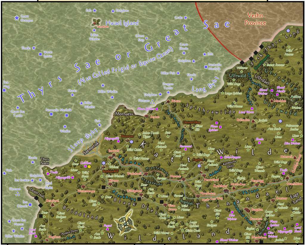
Labels for the illustrated overland creatures and sea creatures & features can be turned-off independently using more of the FCW file's toggles, as they can make things a bit cluttered, especially when viewing something like this overlay of the latitude and polar auroral lines:

As this image demonstrates, we're in the southernmost part of Errynor, between roughly latitudes 44½° and 47½° North (in the extreme map corners), and that the area is almost all south of Nibirum's Polar Auroral Zone. The aurora can be seen still, and its magical influence detected, across the mapped area, though with a lower frequency than within much of the Zone itself.
Then there are the undersea water column and seabed views, again with two images of each to illustrate the separate map keys as laid-out, and more of just the map's detail. The land creatures are not shown on these:
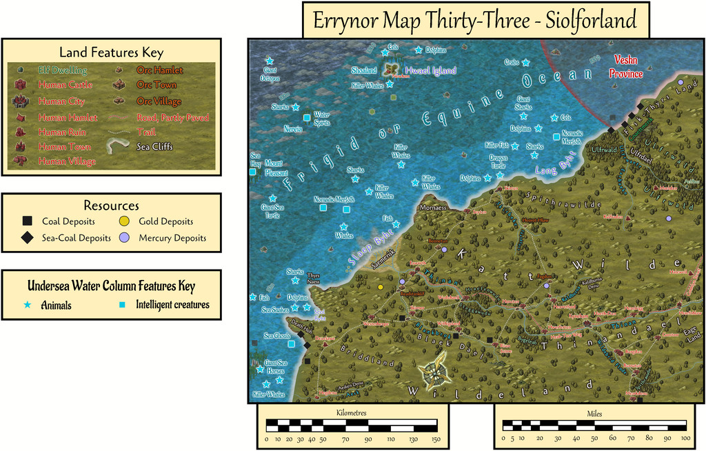
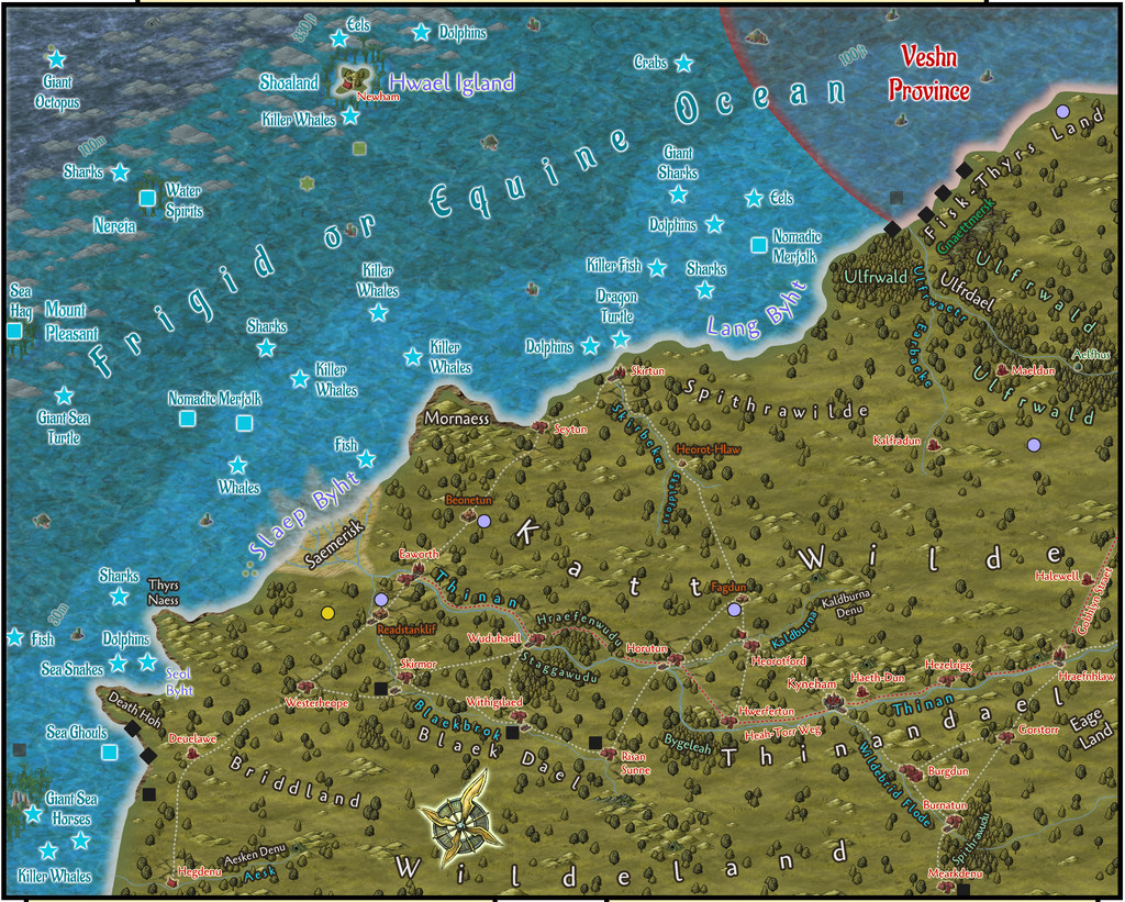
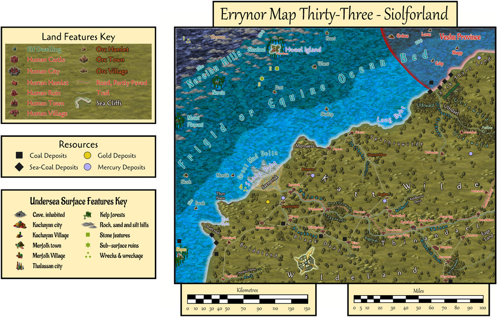
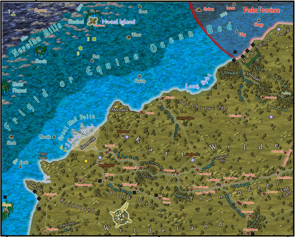
After setting-up the map template and importing the image files I'd be needing to trace-in all the prepared details, my primary concern was resolving the appearance of the two inshore undersea water-depth contours, something I'd not done before. The deepest sliver of the seabed here, furthest offshore, is that below 100 metres water depth, and the look of that, the region between the 100m and 200m depth contours, had been decided already for the map showing the limits of Deep-Sea Hag Aunty MacKassa's domain, across the junction of Maps 1, 2, 9 & 10. These two new shallow-water contours though took days to complete, after a lengthy battle with the complex RGB Matrix Process in combination with the Adjust Hue/Saturation Sheet Effects, and a few more, ultimately unsatisfactory, ideas that were finally discarded.
A further struggle was getting those three isolated low seamounts, Mount Pleasant, Nereia and Shoaland, to still stand out sufficiently among the kelp and other symbols overlying them. Actually, even getting them to be visible with NO symbols over them proved remarkably difficult, because for all the 30m boundary is clear at the edge of its broad strip off the coast, in smaller patches, that definition is quickly lost. However, those small seamounts are meant to have steep, cliff-like sides, not a gradual slope down, so adding the dark edge glow to them seemed justifiable, and made them stand out against the 30-100m water contour band's colouring better, albeit adjusting that "cliff" colouring and size took almost more time than resolving the colouring of the two inshore depth contour bands!
Among the preparations for the map ahead of time was how places were to be named on the land and sea surface view. This was to be using a minor variant of Old English for the local overland dialect of the "Common Tongue". Some of the terms will be likely obvious enough, simply with different spellings and pronunciations - "Sae" is clearly "Sea", for instance, and "Byht" = "Bight". Others may be less-so, such as "Thyrs" meaning either "Giant" or "Demon" depending on context, or "Slaep", which means both "Miry" and "Slippery". The PDF notes accompanying the map will explain more, with translations for all such names.
As for what's meant to be going on here on land and at sea, well there's a quite complex interweaving of activities, mostly associated with the map's resources of coal and mercury (locally "kwikusiolfor", quicksilver in translation, hence Siolforland = Silverland), mining and shipping both out as trade commodities, with the problems of distance and what might also want to seize the goods, or the humanoids and creatures doing the transporting, along the way. The exports are going primarily to the Goblyn Realm of Arkant to the north, a journey of about 900 km, 550 miles, by sea, or at least 650 km, 400 miles, by road. Some also pass east over land to and through the Spiney Ridge Mountains, which start around 550 km, 350 miles, away, over rather poorer roads and even more hazardous lands.
The PDF again has more details, including about the local Orcs, the Siolforfolk, who gain their wild magical abilities from being able to tolerate the presence of mercury without problems or side effects, and the difficulties of the ongoing civil war in the undersea Kachayan (or Sea Devil) Veshn Province. Oh, and there's a Gold Dragon with a fascination for the activities of humanoids across this region.
Incidentally, for anyone peering at the land place-names and wondering how they originated, or those who might be thinking one or two seem vaguely familiar, it's a distinct possibility most derived from real-world place-names in the former coalfield areas of Northeast England (many of which also have modern names determined by their Old English originals)...


