

Community Atlas: Errynor Map 01 - The Cliff
 Wyvern
🖼️ 293 images Cartographer
Wyvern
🖼️ 293 images Cartographer
When I wrote here to present details about my first land-based contribution to the Community Atlas Errynor in northwestern Alarius, I noted that 2,000 x 1,000 mile map had behind it a collection of forty 250 x 200 mile sub-maps, so that in essence, the main Errynor map was a summary of the major points from those 40. I also noted the plan was to present the 40 sub-maps separately over time for the Atlas. This map is the first of those - at last...
My initial thought was to prepare the sub-maps for each corner of the Errynor map, because those would encompass aspects of all the chief landforms, including the undersea areas which had been one main element in determining how the Errynor map was drawn. Wanting to try something different to that main map, I opted for the Herwin Wielink style, as that includes a number of useful options for the range of terrains needed.
However, like most CC3+ style packages, it largely ignores the undersea environment (as discussed in this Forum topic). So I knew from the start I would need to create some fresh symbols for that, though sadly I'm no artist! Needs must, though. Numerous problems beyond anything map-related meant progress with these was very slow, so it was only in February 2020 that those new symbols were completed:
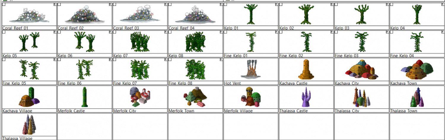
These were all tinkered together in GIMP, incidentally.
Knowing from the outset that I couldn't create anything with the artistry of HW's symbols, I instead drew mine taking aspects from that style only, such as the building bases having a similar fading "looseness" to help blend better into the underlying surface fill textures, and having the building shadows fall on the same side, for instance. Due to the size constraints on what symbol files added to the Atlas can be, I opted for just this very limited number, as I knew others already in the HW style could be reused for additional types quite readily. Of course, as we've discussed repeatedly on the Forum previously, further variants and extra items could be added almost ad infinitum!


Comments
With the new undersea symbols ready, finally I could begin constructing the first map. Logically, this was to be my original Map 1, at the top left corner of the Errynor map:
Clearly, the seabed was going to be the primary aspect here, with just two tiny islands above sea level, so that's where I began:
The tremendous cliff at the continental shelf edge is so dominant here, that had to become the map's name, while the relative sparsity of other undersea surface features had been a deliberate choice from the initial planning of the main Errynor map. What items are shown, are thus those more easily found by new travellers to the area, or those whose presence is more influential for whatever reason. This also reflects the apparent nature, as far as can be established, of Earth's own ocean floors. The shallowest seabed mapped here, towards the lower right corner, lies below some 300 m (nearly 1,000 ft) of seawater, for instance. It further fits with the idea of the relative smallness of the undersea intelligent populations in the region, compared with the vastness of Nibirum's oceans, as I'd envisaged them. There is the further advantage that plenty of space is available for GMs to add extra points of interest, should they wish.
The red-limned regions are Kachaya/Sea Devil provinces, incidentally.
I added a SOLAR/GEOMAGNETICS Layer overlay to show lines of latitude for each 1°, and the midline for Nibirum's polar auroral zone. This option should be available by a toggle for the Atlas version.
These 250 x 200 mile maps are small enough for the north direction to be fairly consistent across most of the area covered, so I'd been able to add a compass rose as well, which hadn't been possible for the main Errynor map.
When designing the hand-drawn paper maps at the start of this project, a selection of larger/more interesting/more dangerous creatures (and things, for the solid surface) that could be encountered had been randomly included. Many of the undersea types were free-swimming. For RPG use, it's naturally important to know where these are not merely for the sea and undersea land surfaces, but in the water column between too. Hence another map toggle, activating the UNDERSEA WATER COLUMN Layer, is intended to shift the view to that water column (it's best to turn off the TEXT, SURFACE UNDERSEA Sheet for clarity first):
This view isn't at a fixed depth below the sea surface, simply to illustrate in general what can be found somewhere in the water column. Thus although the great seamount rock columns of Zariq and Zaraq have been given physical dimensions here, those are representative only. An 11-page PDF of the map's accompanying text-file notes explains this, together with detailing various of the other more noteworthy features shown.
A third toggled view, turning on the COAST/SEA Layer, shifts us to the sea's surface, where the seamounts have become small islands, and the midwater denizens have been joined by several ghost ships and an area where floating wreckage collects from time to time:
By turning off the SYMBOLS, SEA SURFACE Sheet, the paucity of sea surface features is very clearly seen!
GMs here may be unsurprised to learn I became distracted by some of possibilities of this map while drawing it into CC3+, as I've hinted in some of my more recent Forum posts here. Consequently, instead of progressing immediately to the next Errynor sub-map, I embarked on a group of feature maps from this one first. Plus, it also seemed unhelpful to not provide some guidance regarding the nature of the undersea features, especially the sea-bed settlements, for future mapping, as this is something scarcely touched-upon by published RPG settings and adventures. Thus this one map has become merely the first in a package of around twenty from this one area, which explains much of the delay in getting them ready for the Atlas, given I felt the whole group needed to be finished before any were submitted, in case changes were needed to those prepared earlier in the sequence - and that has happened along the way.
In fact the maps were prepared relatively quickly in each instance with CC3+. The most time-consuming aspect has been preparing and checking the detailed write-ups for them, as these are what has particularly allowed me to explore and expand upon ideas regarding fantasy undersea environments that I've been mulling over in part for decades.
Rather than drop the entire set on Monsen at once, my intention is for a gradual "release programme" with a new map or map-group only every few weeks. Maybe this will give me time too to complete more of the "Errynor 40" maps along the way, hopefully not taking quite so long each...
First map of the set is now in the atlas. Thanks for contributing. This is an exciting project.
Awesome work, Wyvern :)
Thanks Sue!
And also Monsen for getting this into the Atlas. We hit a few glitches along the way, but it seems to be all sorted successfully now!