

Community Atlas: Errynor Map 33 - Siolforland
 Wyvern
🖼️ 293 images Cartographer
Wyvern
🖼️ 293 images Cartographer
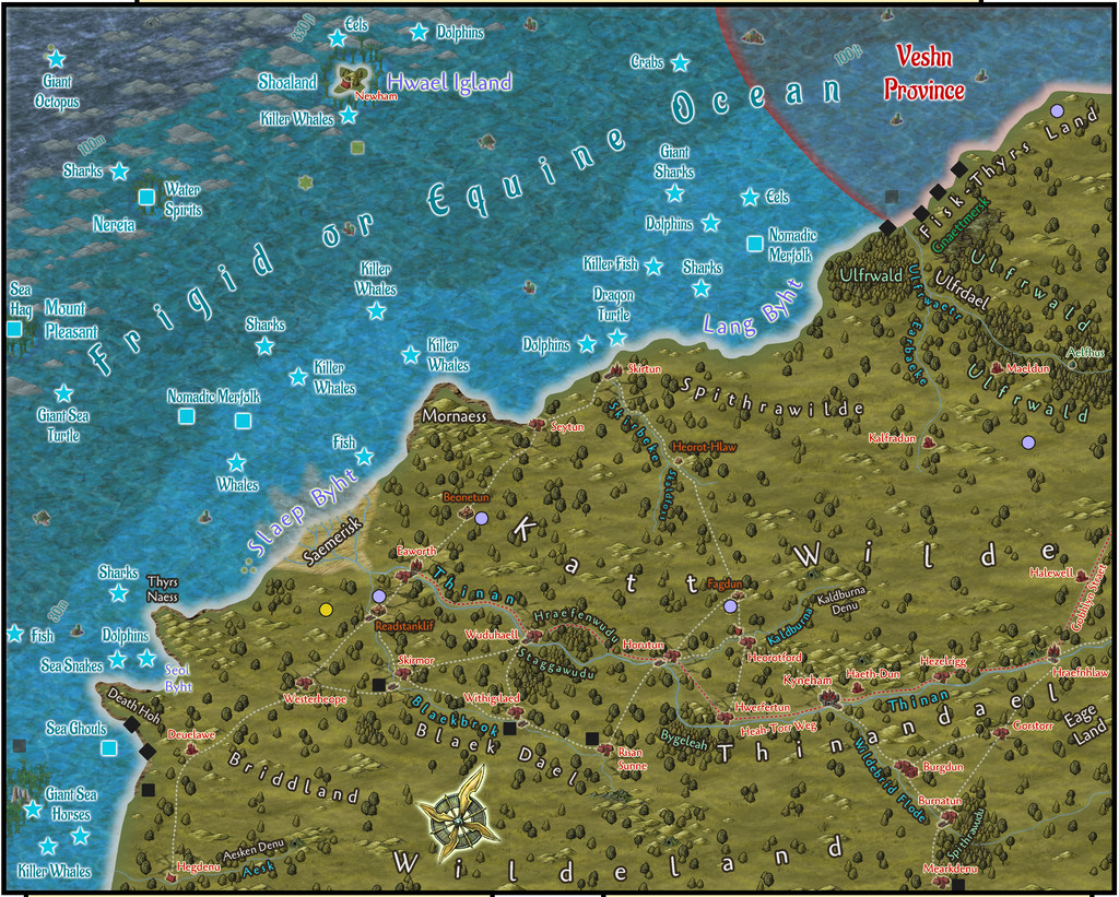
The next map in the set of 250 x 200 mile areas from "my" corner of Alarius is now ready for the Atlas. It's the one in the lowest left corner of the Errynor region, Map 33:
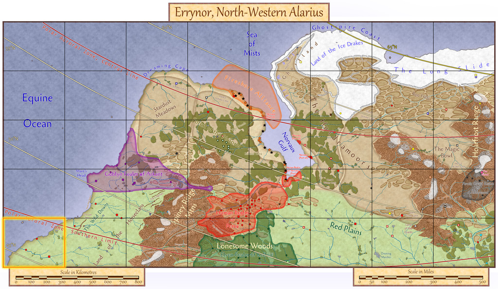
This map choice was part of the ongoing process of gradually introducing fresh major elements to each new early map. Having completed the corner maps for the deep waters far offshore (Map 01, top left) and the area furthest from the sea (Map 40, lowest right), it seemed logical to proceed with a coastal and shallower water map this time. While Map 8 (top right) includes those aspects, it also has the extra feature of an ice sheet which conceals part of the underlying coastal terrain. Map 33 then more or less chose itself.
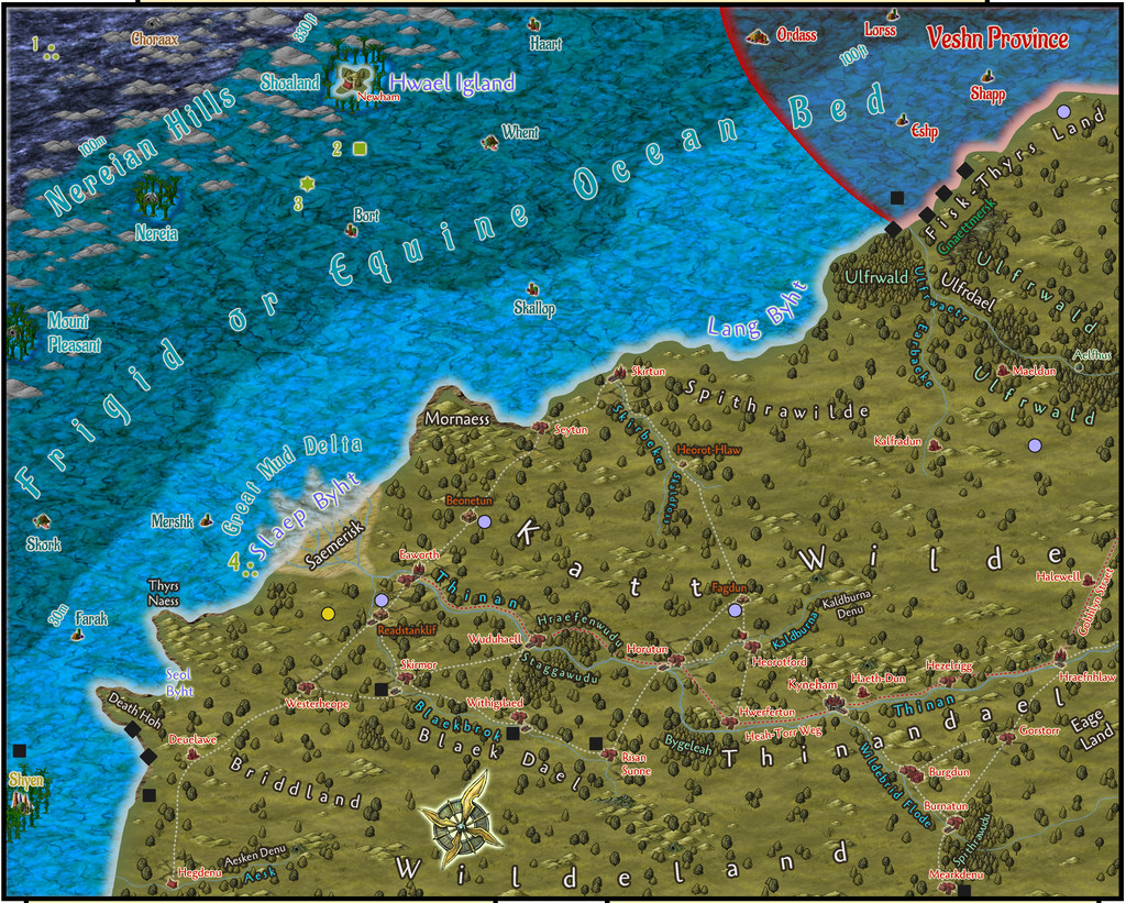
The final Atlas FCW map will have toggles to show various viewing options, as usual. Starting with the sea surface view, the first image below has the full map with scales, keys and so forth, while the second is just a close-up of the map, where hopefully more of the labels can be read still at the typical Forum resolution (the map views have been added at a somewhat higher res in my Gallery too):
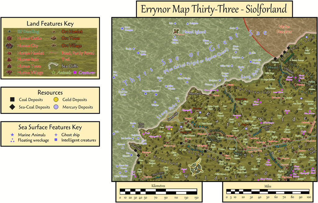
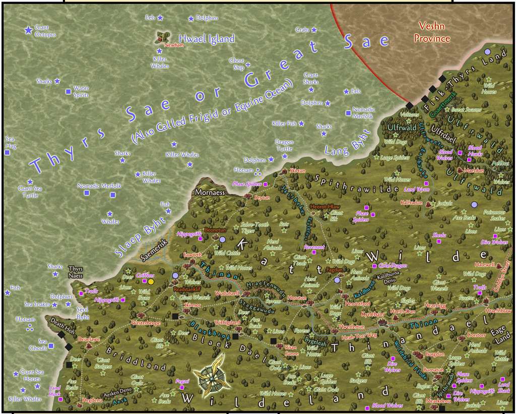
Labels for the illustrated overland creatures and sea creatures & features can be turned-off independently using more of the FCW file's toggles, as they can make things a bit cluttered, especially when viewing something like this overlay of the latitude and polar auroral lines:

As this image demonstrates, we're in the southernmost part of Errynor, between roughly latitudes 44½° and 47½° North (in the extreme map corners), and that the area is almost all south of Nibirum's Polar Auroral Zone. The aurora can be seen still, and its magical influence detected, across the mapped area, though with a lower frequency than within much of the Zone itself.
Then there are the undersea water column and seabed views, again with two images of each to illustrate the separate map keys as laid-out, and more of just the map's detail. The land creatures are not shown on these:
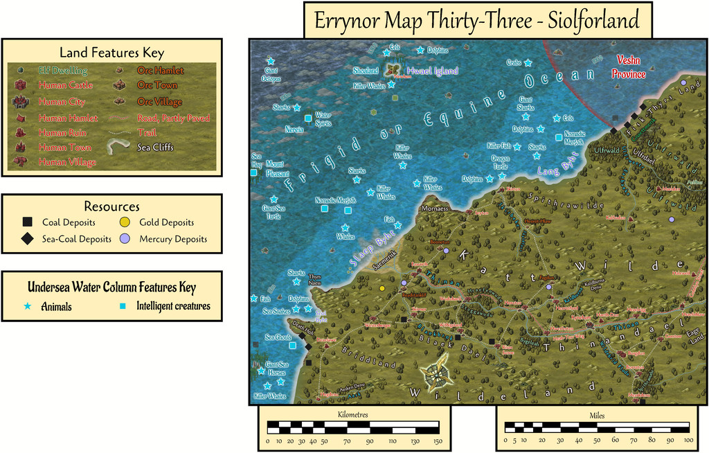
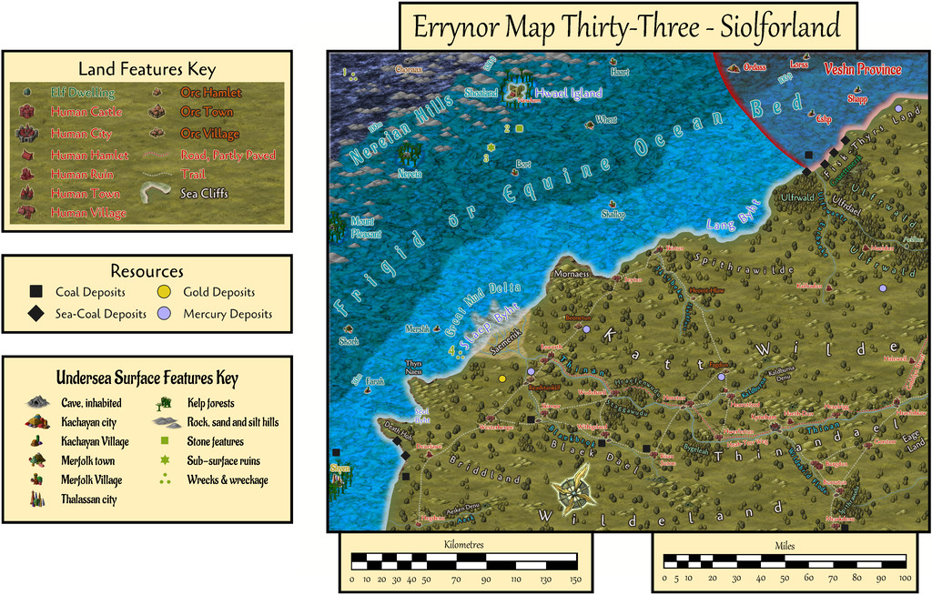
After setting-up the map template and importing the image files I'd be needing to trace-in all the prepared details, my primary concern was resolving the appearance of the two inshore undersea water-depth contours, something I'd not done before. The deepest sliver of the seabed here, furthest offshore, is that below 100 metres water depth, and the look of that, the region between the 100m and 200m depth contours, had been decided already for the map showing the limits of Deep-Sea Hag Aunty MacKassa's domain, across the junction of Maps 1, 2, 9 & 10. These two new shallow-water contours though took days to complete, after a lengthy battle with the complex RGB Matrix Process in combination with the Adjust Hue/Saturation Sheet Effects, and a few more, ultimately unsatisfactory, ideas that were finally discarded.
A further struggle was getting those three isolated low seamounts, Mount Pleasant, Nereia and Shoaland, to still stand out sufficiently among the kelp and other symbols overlying them. Actually, even getting them to be visible with NO symbols over them proved remarkably difficult, because for all the 30m boundary is clear at the edge of its broad strip off the coast, in smaller patches, that definition is quickly lost. However, those small seamounts are meant to have steep, cliff-like sides, not a gradual slope down, so adding the dark edge glow to them seemed justifiable, and made them stand out against the 30-100m water contour band's colouring better, albeit adjusting that "cliff" colouring and size took almost more time than resolving the colouring of the two inshore depth contour bands!
Among the preparations for the map ahead of time was how places were to be named on the land and sea surface view. This was to be using a minor variant of Old English for the local overland dialect of the "Common Tongue". Some of the terms will be likely obvious enough, simply with different spellings and pronunciations - "Sae" is clearly "Sea", for instance, and "Byht" = "Bight". Others may be less-so, such as "Thyrs" meaning either "Giant" or "Demon" depending on context, or "Slaep", which means both "Miry" and "Slippery". The PDF notes accompanying the map will explain more, with translations for all such names.
As for what's meant to be going on here on land and at sea, well there's a quite complex interweaving of activities, mostly associated with the map's resources of coal and mercury (locally "kwikusiolfor", quicksilver in translation, hence Siolforland = Silverland), mining and shipping both out as trade commodities, with the problems of distance and what might also want to seize the goods, or the humanoids and creatures doing the transporting, along the way. The exports are going primarily to the Goblyn Realm of Arkant to the north, a journey of about 900 km, 550 miles, by sea, or at least 650 km, 400 miles, by road. Some also pass east over land to and through the Spiney Ridge Mountains, which start around 550 km, 350 miles, away, over rather poorer roads and even more hazardous lands.
The PDF again has more details, including about the local Orcs, the Siolforfolk, who gain their wild magical abilities from being able to tolerate the presence of mercury without problems or side effects, and the difficulties of the ongoing civil war in the undersea Kachayan (or Sea Devil) Veshn Province. Oh, and there's a Gold Dragon with a fascination for the activities of humanoids across this region.
Incidentally, for anyone peering at the land place-names and wondering how they originated, or those who might be thinking one or two seem vaguely familiar, it's a distinct possibility most derived from real-world place-names in the former coalfield areas of Northeast England (many of which also have modern names determined by their Old English originals)...


![[Deleted User]](https://secure.gravatar.com/avatar/c75d9a245b74d9c59be0999ea81ca541/?default=https%3A%2F%2Fvanillicon.com%2F92add7f8c954488718110edc4896ad39_200.png&rating=g&size=200)


Comments
While the choice and location for most of the map's non-landscape features were decided randomly, as done, and discussed, for previous of these Errynor maps, this time not all the settlements were, as just over half the smaller ones were added subsequently, chiefly along the main river lines in the lower half of the area:
Those that were located randomly had helped determine the general layout for the river lines, in combination with the more obvious geographic requirements. After the resources were added, again randomly, the curious concentration of several coal markers near these established waterways helped provide the spark for what became the civilisation hereabouts, as portrayed in the map's PDF file. Adding the "missing" coal mining villages deliberately to complete the pattern, led naturally to providing mining settlements near the mercury deposits that didn't already have one, plus of course there would be further smaller places, down to individual farmsteads, were this map not at the "large-regional" scale it is.
Route junctions, bridging points, minor landscape features and nearby creatures then helped generate ideas for the varying local character of particular settlements, with names then either chosen to suit those, or sometimes where the names helped give an extra concept of what might be happening at certain places, beyond anything obvious from their physical siting.
Having done that on land, a couple of smaller settlements were added undersea as well to round things off more, along with one last non-random settlement on Hwael Igland ("Whale Island"), since this little island took on an increasingly important role during the development of ideas regarding the ocean trade-route to Arkant from here. However, Hwael Igland is the subject of another Atlas map, so that's a story for another time!
Thanks Wyvern. Maps are now in the atlas.
Gosh, that was quick Remy! Thanks very much!
I still have to finalise my Forum notes for the Hwael Igland map, so you'll all have to pretend you haven't seen it yet till then!
Hwael Igland Forum notes now added!