Loopysue
Loopysue
About
- Username
- Loopysue
- Joined
- Visits
- 10,416
- Last Active
- Roles
- Member, ProFantasy
- Points
- 10,161
- Birthday
- June 29, 1966
- Location
- Dorset, England, UK
- Real Name
- Sue Daniel (aka 'Mouse')
- Rank
- Cartographer
- Badges
- 27
Latest Images


-
[WIP] Trying to design a barrel roof
A Blend Mode effect is similar to the blend modes used in PS or other bitmap apps to apply effects between their layers, only in this case it's between sheets. If you turn all the polygons mid-grey their shading will create a relatively smooth 'arch' without the fizzy appearance of any texture. You can then blend this to a nice simple rectangular polygon of a roof texture of your choice on an underlying sheet using a Blend Mode set to 100% opacity and Soft Light. Soft Light is a Blend Mode that will shade and highlight the underlying roof texture according to the shade and light of the roof arch.


-
Quoting an Old Post in a New Discussion
You can copy the relevant text and paste it into your new thread, then click the syntax mark to the left of the pasted paragraphs and set the style to be a quote.
Like this
Don't forget to add credit to the person who wrote it.
...
Or you could just hyperlink to the comment:
Go to the comment you want to quote, right click the time stamp under the name of the person who made it and copy the link. You can then paste it into your new comment and hit return. Providing the quoted comment isn't a mile long it should appear in a box.


-
SS5 and B&W Cities
It's been a while since I played with SS5, but I remember one way of turning the map to greyscale was to add an RGB Matrix Process to the Whole Drawing and pick the Gray preset for it.
The fact that the folder is called Color doesn't mean there is a black and white version.
Here is a shot of one of the example maps with the RGB Matrix Process added.
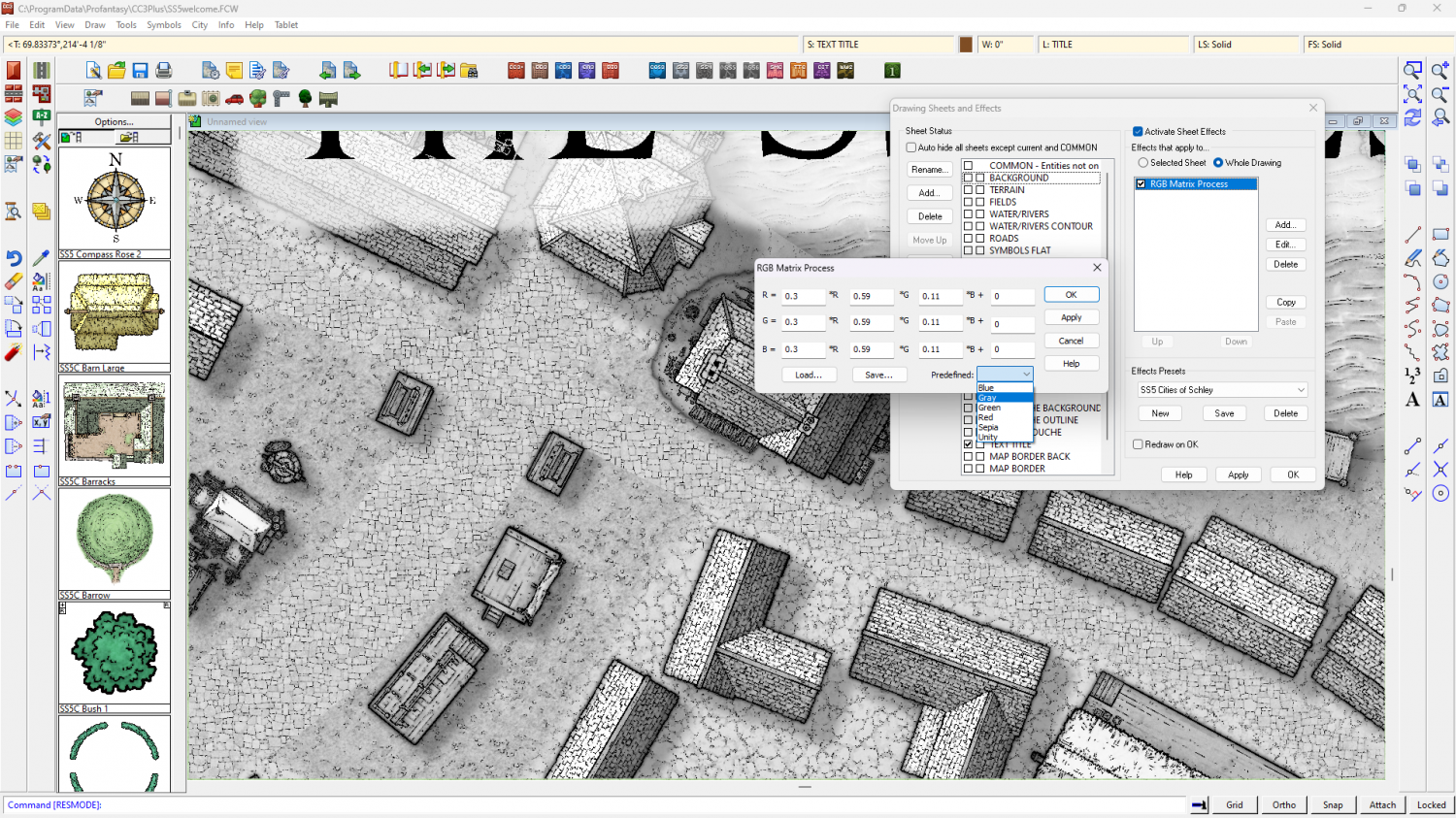
I've just noticed that you may have to change the shade of the glow on the text sheet to the palest grey to stop bits of the letters falling out when they are over black parts of the map.
Theoretically, you should be able to turn any style to greyscale using the same method, but I've not tried any of the others.

-
Live Mapping: Scorching Sun
Hi everyone! :D
In this week's live mapping session Ralf will be using the Scorching Sun overland style from the 2016 Cartographer's Annual to show the map creation process in a beginner-friendly way.
Come along and join us on Youtube for the live chat here:
https://www.youtube.com/watch?v=_85HPtCkR_8
Or if you prefer you can watch it here (though there is no live chat on the forum)
All are welcome to join in the chat.

-
Live Mapping: Sarah Wroot Revisited
Hi everyone! :D
Ralf is back from Gen Con, so this week he will be showcasing the latest annual issue: Sarah Wroot Revisited.
Come along and join in the chat, live on Youtube:
https://www.youtube.com/watch?v=BoBIilrjJAE
Or if you miss the show you can always watch it here:
We look forward to seeing you :)

-
CA212 Terrains with Symbols not working
Here's a short checklist of the repair process:
- Delete the forests in your existing map, save the map and close CC.
- Download a fresh installer for Sarah Wroot Revisited, and install it by right clicking the icon and picking Run as Administrator. Use the Repair option, and allow CC to open the example map at the end of the installation.
- Reopen your map and try drawing a new forest.
If that doesn't work you might have to contact Tech Support.
-
Mapping Europe 1790s
The dotty fill is the grey shading. I don't think we have one like that, though I do remember showing a dotty fill on here some considerable time ago. It's not a published fill.
I found it! Wow, that really was a very long time ago. The third one here is probably a possible fill, but use it very small scale so it looks grey. https://forum.profantasy.com/discussion/7039/dotty-fills


-
Sticky Note Dungeon
You can make separate symbol catalogues from the same folder if you haven't split them into subfolders.
Check out page 90 in the Tome for the basics.
If you get stuck, just shout.

-
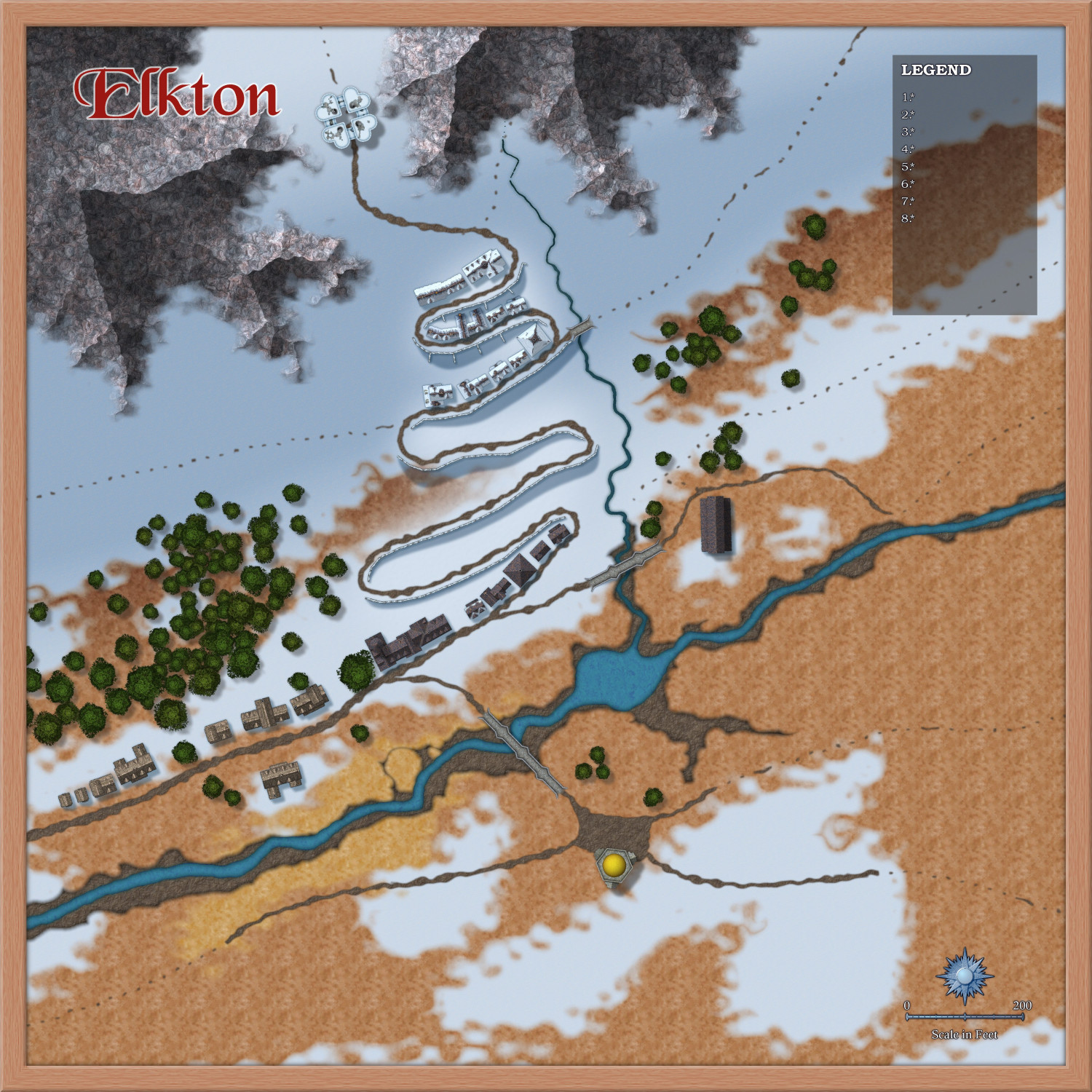
[WIP] 1000th Map Competition: Elkton, Alarius North Central
Experimentation with rocky bits and patches of possible mud and tundra.
I hope it looks like the village that isn't there yet is on a steep slope.


-
[WIP] 1000th Map Competition: Elkton, Alarius North Central
I got a little more done this evening after work. Quite pleased with the way the terracing has worked out.