


Wyvern
Wyvern
About
- Username
- Wyvern
- Joined
- Visits
- 3,267
- Last Active
- Roles
- Member
- Points
- 5,585
- Rank
- Cartographer
- Badges
- 24
Latest Images


-
Style Request: East Asian Floorplan/Dungeon
Isometric building and room maps can look good for players, but they're often a nightmare for GMs trying to run an adventure, where you need to know exactly where everything in a room is at a glance, and how it connects to everything else in its vicinity. A top-down map gives you that control, plus for players, they can see instantly where everything is too, as battlemaps, for instance.
Iso can have its uses for a GM though, where flat wall features (such as carvings) might be important, say, though that may need several views so all walls can be identified and seen clearly.
Slightly concerned that "East Asian" seems to be being redefined as just meaning "Japan" here, given Japan's a tiny fraction of East Asia overall. Might be better to retitle this topic as referring to Japan only? Or expand the discussion to include features from China, Mongolia, the Koreas, Taiwan and perhaps places adjacent as well?


-
Live Mapping: Sticky Note Dungeon
Might be worth mentioning too that we found a minor glitch with the Sticky Note Dungeon Regular font, which has also been updated in the Annual download now. However, being a font, you usually can't just overwrite this on a Windows system, so you may need to remove the original font first (it should be in the Windows - Windows - Fonts subfolder) before you reinstall.
If you have already done a fresh reinstall though, just remove the font then do a repair reinstall using the Sticky Note Dungeon EXE file, and that should sort it (I have done just this as a check!).


-
Sticky Note Dungeon
And now the Sticky Dungeon has been released into the wild, as the October 2024 Cartographer's Annual issue!
Many congratulations to C.C. for this fantastic achievement!
-
The Creepy Crypt project
Yet still no cat... 😁🐈️

-
[WIP] 1000th Map Competition: Elkton, Alarius North Central
Sure they aren't were-elks Sue? 😉

-
Real World Overlays
@roflo1 commented: "I was browsing the Annuals pages, and stumbled upon this:
https://www.profantasy.com/annual/2014/august14.html
I don't own that annual, but perhaps someone else can comment on it?"
This is the Annual issue 92 Quenten referred in his Oct 22 note above (only obvious if you can convert the month and year into a number correctly for the Annuals, however, so no blame attaches!).
The issue covers importing and converting real-world vector data from the free-access Natural Earth website (there's a link from the Aug 2014 Annual page) into CC3, and comes with a group of so-converted FCW sample maps of the world. It especially concentrates on converting the continent of South America into a standard CC3-look overland map as its worked example, albeit with just the coastline and rivers illustrated (you get three FCW maps showing the process). There are also files with the 1:10 million vector data that were used to create the various CC3 maps with the issue.
Can't really say much more, as although I've had it for some time, I've never used this particular issue of the Annual, and it could be a while before Ralf gets round to demonstrating it in his weekly YouTube live-streams, unfortunately, as last week's covered issue 15!
It does seem as if it should be possible to prepare the sort of map @serious77 was wanting using it though.


-
The Creepy Crypt project
Dee-licious! 🍳

-
Panzer sample thread
So far as I recall from modelling the 8- and 6-rad armoured cars (i.e. also from period images and information), the aerials were fixed in position, and at a height above the turrets all the time. These are the early-war "bedstead" frame aerial types, not the later war smaller "star antennae" which were retrofitted to some models, incidentally.
Oh - and belated congratulations on your ascension to Master Mapper status @Lillhans ! Very well done!


-
Community Atlas: Errynor Map 33 - Hwael Igland
Well, it's already in the Atlas, but these notes maybe add something regarding the creation process, and some of the problems encountered in preparing it. So, as mentioned in the Siolforland map Forum topic, I wanted to add an additional map to that main one, for the little offshore isle of Hwael Igland, although this is actually the largest of my planned islands off Errynor. During the original planning for this whole Errynor mapping project some years ago, I'd brought together a number of randomly-generated ideas, including a series of base-maps for the scatter of tiny islands in Errynor's seas from the island generator on the Red Blob Games website. The base chosen here was:
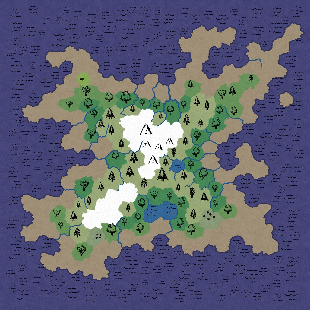
This is only one of the map views the site generates, showing just the chief biomes, with symbols and colour-coding. Other views provide more detail on the physical terrain. The rough-edged, sort-of hexagonal pattern the random system uses to create the map is naturally quite obvious here, although personally, this is quite appealing anyway, and produces some interesting coastal shapes especially. The random maps have no scale illustrated, so adjusting them to whatever size is needed is very straightforward, and here largely revolved around calling the mountains "hills", and the rivers "streams".
When generating the random island base maps, I had the overall shape for each in mind from my original hand-sketched Errynor maps, and simply tried different random options until I arrived at a suitably-shaped island for each. In this case, I'd decided this shape fitted what I'd already sketched, but only once it was inverted, as suggested by the final Siolforland drawing, even if the similarity is a bit vague:
Of course, the random base map is very incomplete, given the final Island needed at least one settlement on it, and for an Atlas map, it also needed further points of interest adding. So a series of fresh random rolls on my small-scale-map-feature tables were made, after which a fresh evaluation of the landscape was carried out, and some adjustments made, including factoring-in considerations from the Siolforland mapping (such as the already-decided height of the highest peak on the Island). Then the CC3+ mapping could begin.
As normal, I'd identified several possible mapping styles to use. Here, I was picking from some of the simpler black-and-white styles, suitable for the relatively small area involved. Partly this was a reaction against having been mapping purely in colour for some considerable time up to this point (not simply with my Errynor mapping), and partly a reaction to having mapped two Errynor islands previously in colour, Zariq and Zaraq on Errynor Map 01. However, the style I eventually settled upon, "Treasure Maps" from CA58 in 2011, was one I have used before in Errynor, when mapping the seafloor surroundings of the Kachayan settlements at Shark Bridge in the deep ocean of Map 01. On that occasion though, I'd really used little more than a couple of symbols, the backdrop parchment fill and font from the Annual issue, and had drawn my own not-symbol vector-shape objects for use there instead. This time, I was using the style more as it was meant to be, for a sea-surface island:
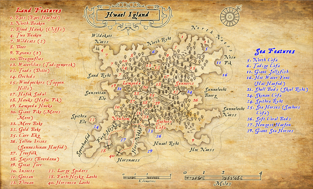
Once drawn, as soon as I started adding the labels, it became very obvious space wouldn't allow them all to be fitted on the map, so the background rapidly had to expand to fit the points-of-interest listings, to which I added a further minor complication by using colour-codings for the features on land, and those around the coast and in the sea, while retaining just the one numerical sequence! And then in the PDF description, I added-in the named places, breaking-up that sequence still further, which was an interesting experiment in producing a non-alphanumeric index...
Part of the reason I'd chosen this mapping style was because it allows the drawing of cliffs, as well as providing other landform symbols. The perceptive will, however, notice there aren't any cliffs drawn on the final map. Unfortunately, I soon discovered that at this map's size, the cliffs looked unworkably clumsy, as the drawing tool for them uses a non-scalable hatch fill, and moreover it sometimes reacts very badly to drawn polygons containing strong convex and concave curves (such as when trying to illustrate that cliffs continue right around a narrow peninsula, or a coastline with substantial indentations). In such cases, it can force part of the hatch fill beyond the drawn borders, so that the land looks like it's ALL cliffs in places, not just at the coasts. Even drawing the cliffs in small segments didn't work, because sometimes there was scarcely anything visible to show there were meant to be cliffs within the polygon area, and others where the polygon was almost all solid black fill. So I settled for relying on just descriptions in the PDF for where the cliffs lie (there are meant to be at least low cliffs around most of the Island's shores, and a couple of places where they're inland too).
There's a similar issue with the hatch fills for the marshes and the "grassy-look" texture on the hills, though luckily the hill symbols don't rely on that hatch fill, as they're scalable objects in their own right, as normal, while there's a series of individual marshland symbols in the Annual as well (which I was particularly relieved to find after trying the marsh drawing tool, with similar problems to the cliffs). I toyed briefly with drawing suitable shapes into separate polygons for the cliffs I wanted, only to veto that as far too time-consuming in this case. I assume part of this problem stems from the fact the style's intended to be used for maps around 20-25 miles or so across (as the PDF mapping guide suggests), whereas Hwael Igland fits very easily within a 10-mile square.
Despite this, I was pleased with how the final map had worked out, and to have had the chance to play around with a style I'd barely touched previously.
-
SS6 - free imperial grid
Yes please, another vote in favour of having the grids as options in the final SS6 - imperial and metric!


