


Wyvern
Wyvern
About
- Username
- Wyvern
- Joined
- Visits
- 3,266
- Last Active
- Roles
- Member
- Points
- 5,585
- Rank
- Cartographer
- Badges
- 24
Latest Images


-
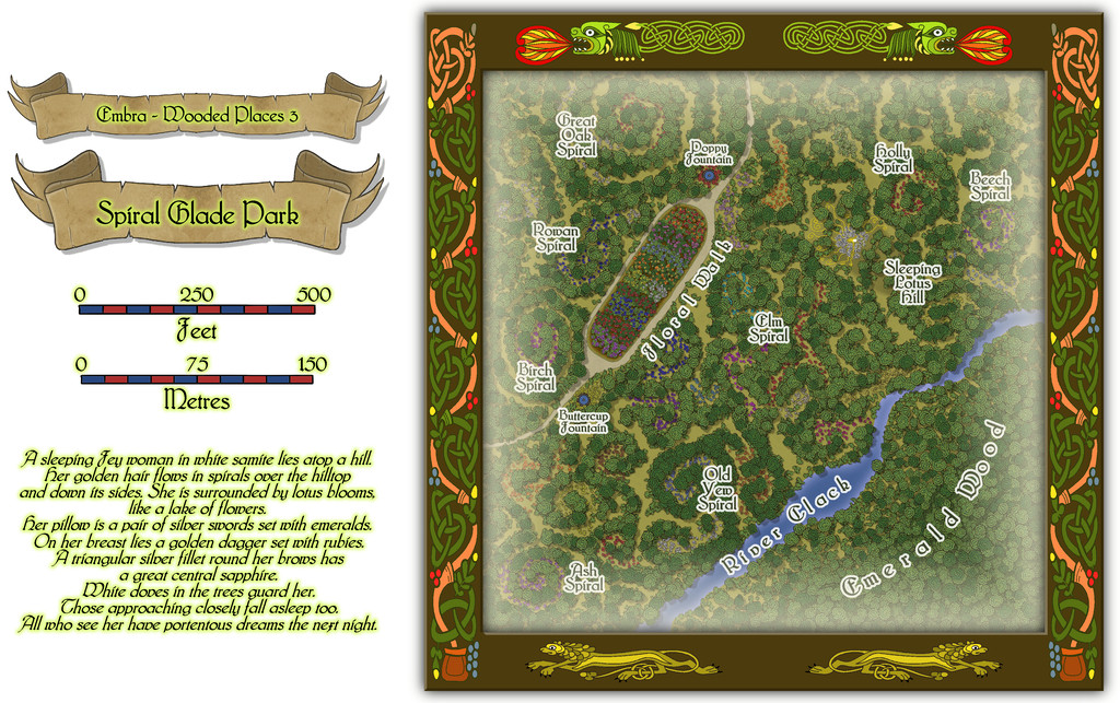
Community Atlas: Embra - Wooded Places
The third map in the Wooded Places set gave me an opportunity to try something I've wanted to do for a long time, map some spiral patterns in woodland. Those sufficiently familiar with fantasy fiction might guess the idea originated in the "Mythago Wood" tales by Robert Holdstock (the original novel, "Mythago Wood", was published first in 1984), which made a lasting impression on me from when I read them back then. The final map though bore only a mild, passing resemblance to its original base. Thus came to be Spiral Glade Park:
The details are a little tricky to see at this resolution, so again, we can try a somewhat closer view of just the map part:
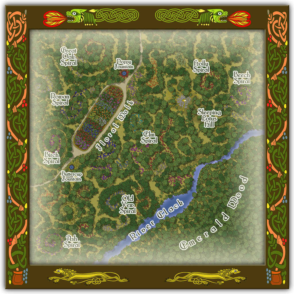
For those wondering, yes, Sleeping Lotus Hill does have a simple sketch of the sleeping Fey woman in white of the map's featured text, and her spiralling golden hair, surrounded by lotus blossoms. There are also a lot more flowers scattered across this map, as with several other of the Embra Places, of course. The PDF and text file notes suggest some possible benefits from traversing the spirals, and a warning regarding the curious grassy hummocks mostly hidden by the lotuses...

![[Deleted User]](https://secure.gravatar.com/avatar/c75d9a245b74d9c59be0999ea81ca541/?default=https%3A%2F%2Fvanillicon.com%2F92add7f8c954488718110edc4896ad39_200.png&rating=g&size=200)
-
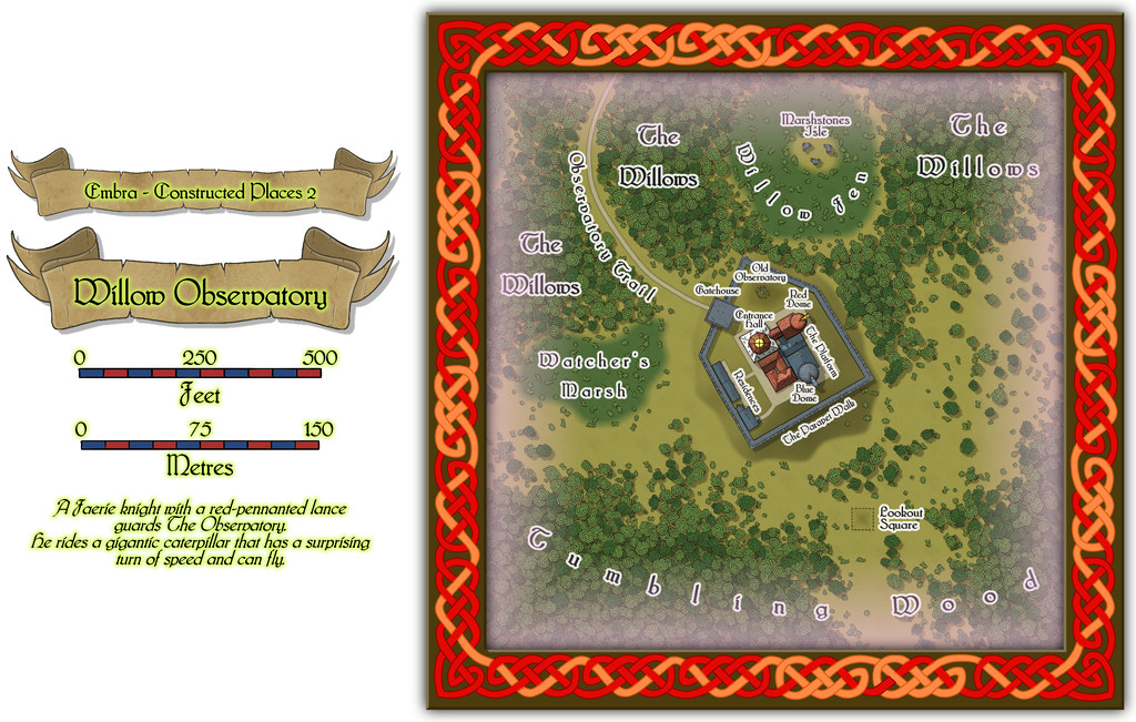
Community Atlas: Embra - Constructed Places
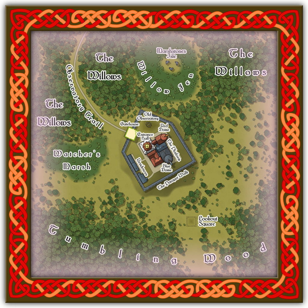
Place 2 is the Willow Observatory, inspired loosely by the real-world astronomical observatories at Edinburgh, Royal Observatory Edinburgh (which is some distance from the city itself) and Calton Hill Observatory, which is right in the city centre, and the consequent long tradition of watching the night sky from there. While some of that tradition was used to inspire what happens at Willow Observatory (including the annual summer activity of looking-out for dragon ghosts in the all-night-twilit northern sky; you'll have more luck trying a search for "noctilucent clouds", should you wish to learn more before the PDF and text files are available), the setting is purely Embra, as the misty marshes and woods nearby would scarcely seem conducive to dedicated sky-watching if anywhere else. And who knows what you might see on the planets of the Nibirum Solar System using one or other of the great magical telescopes here:
Building interiors:

And the upper interior floor for the Gatehouse:
Plus there are oddities nearby, all of which receive at least some discussion in the accompanying notes.

-
Ancient maps
That 22-foot Roman Empire map is the Peutinger Table, aka Tabula Peutingeriana, and the Wikipedia page includes a high-res complete image of the whole - may take a while to load, however, as the full-size JPG is about 15 MB. This is the direct link to that Wikimedia image.

-
Community Atlas: Monseignor District in Kentoria
As I noted after completing my Dendorlig Hall project last October, I'd hoped to have returned to my Alarius mapping by now. Other matters intervened however, and are liable to persist through at least the first quarter of this year too, so I thought it worth trying some smaller mapping projects for a while instead. Partly, this came about following discussions with a few folks on a Discord regarding what to do about possibly continuing with the Dungeon23 concept this year, given almost no one had persisted all year with that, and few had accomplished anything like what they'd hoped for it.
The concept I have for myself currently is to try to map a small dungeon or area each week or so, which, although probably impractical in the long-term, does provide a focus of sorts. Those I complete will all go into the Community Atlas, and following my normal preference for some element of randomness about such Atlas creations, I decided to use the Inkwell Ideas dice sets to generate the base maps in all cases.
For those unfamiliar, the Inkwell dice sets are packs of themed, over-sized, six-sided dice (D6s), where each face has on it a different geomorphic dungeon or cavern drawing. The packs contain either five, six or eight such D6s, and there are currently 12 packs available, three of which are overground settings, nominally "Villages", "Cities" and "Ruins", although the "Ruins" dice are duplicates of the "Cities" ones, where parts of the design have been wholly or partly destroyed. Twelve packs, you say 😁? As in months in a year...
By using random numbers, and selections, of dice from each set, I've generated 52 individual hand-drawn maps based on what the dice provided, which designs were then randomly allocated to places on Nibirum for which regional maps existed in the version of the Atlas I'd most recently downloaded, albeit from earlier last year. The ultimate placements for almost none have been finalised yet, as I'm opting to identify specific locations for them only as I'm progressing. So far, things may turn out to be more complex than I'd hoped, as it may be additional smaller area maps will be needed for many of these along the way too, to define more exactly where they are.
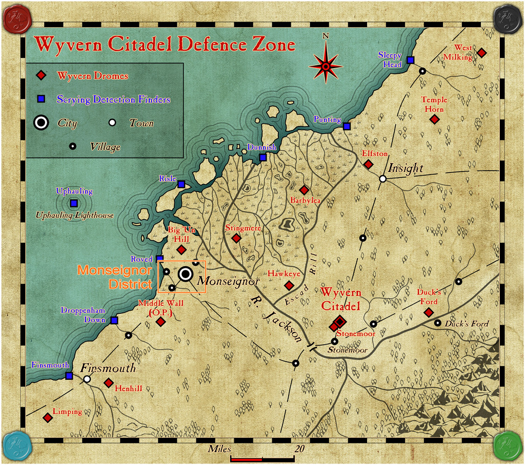
However, the first small map and its new area map are complete, and have been submitted for the Atlas, having oddly enough landed by-chance right into one of my own area maps, the Wyvern Citadel Defence Zone on Kentoria!
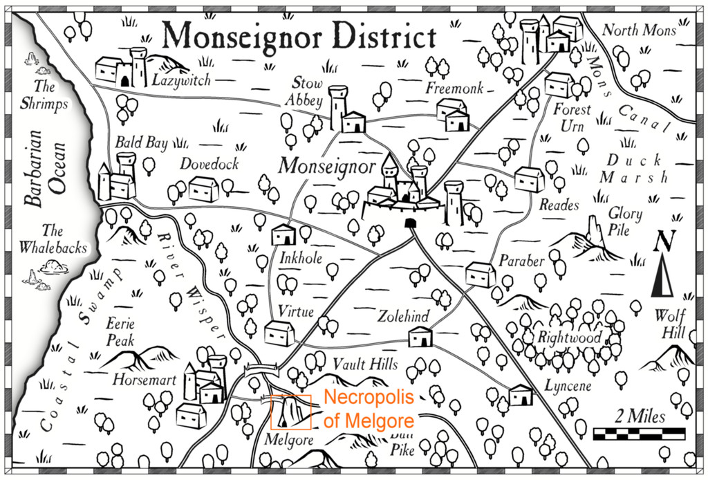
Although actually prepared in order of dungeon first, then overground, when going into the Atlas, this situation of course is reversed, so the general area the dungeon was to end up in has first to be identified, what became the Monseignor District map, whose placement was to be here:
That area now looks like this, in more detail:
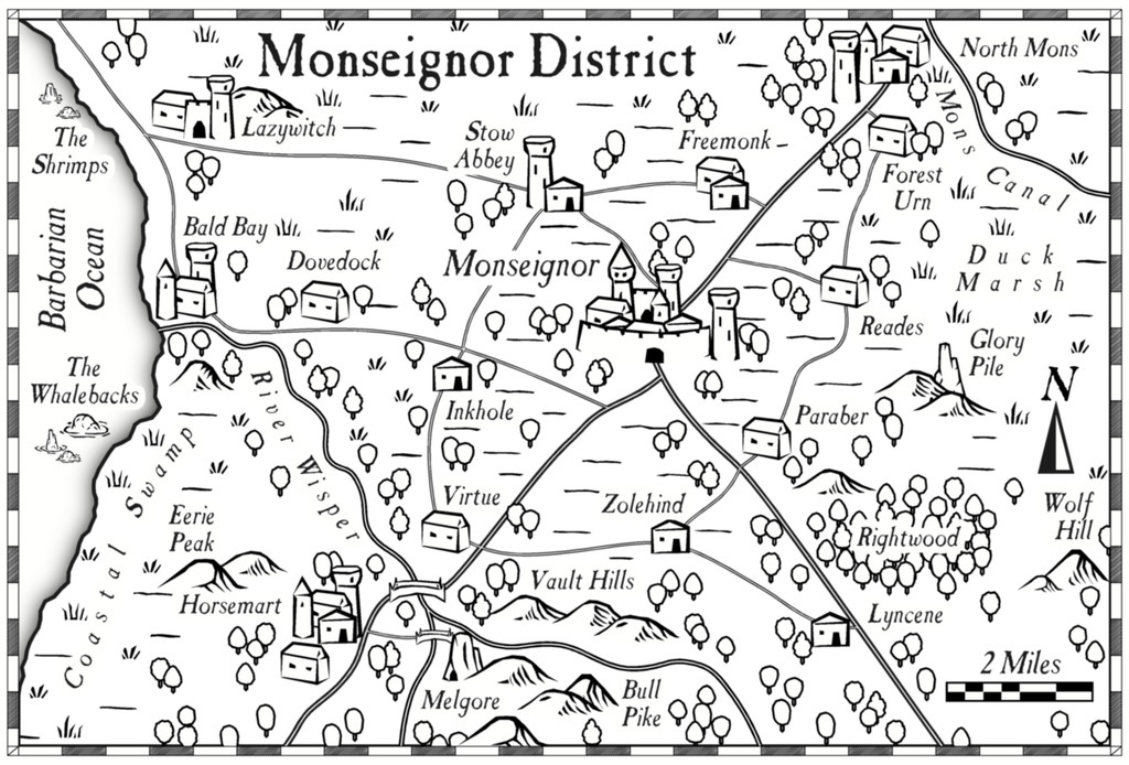
Or at least it does using the Overland Black & White style from Annual 20. Most features had already appeared in the earlier larger area map, or its description, although now some semi-random names and features could be added to those previously unnamed and not shown. Plus of course, the location of the dungeon map had to be provided as well, at Melgore:


-
Community Atlas: Embra - Constructed Places
Last of the individual sites is the Twilight Market setting for this group of Places, Candlelight Hall. The Hall has a huge, pale-blue, glass-tiled roof over much of it, and while that was straightforward enough to draw - CD3 tiled roof shaded polygon with added Sheet Transparency Effect - the support structure took rather more thought and effort, albeit "Trim To Entity" does work wonders in cases like this, for all those roof beams. The view complete:
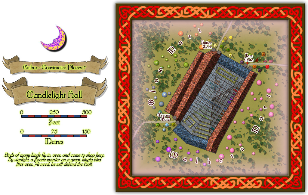
Even this view indicates the interior had to be quite heavily detailed while the roof was left in place, and for once it was prepared normally with fills and symbols, not just the cream-and-green plan sketches all the other Embra interiors have received. The "normal" image above does allow the focus to be a little more on the scatter of other stalls and tents outside the Hall itself, before plunging inside. And so to that interior:
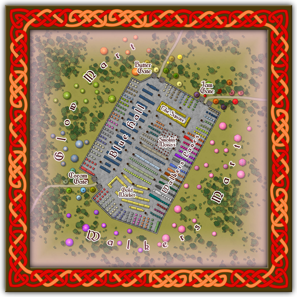
Peering closely suggests there are a lot of windows piercing the walls, all narrow, high, point-topped, and painted with a great assortment of subjects and scenes, which with the huge see-through roof area, means that at twilight or in the dark, the lights from inside shine out like a beacon from here, partly hence the name. And just in case you couldn't guess, Smokin' Mona's is THE restaurant for this part of the Market.
Comparing the two views here, one other element becomes clear. The internal labelling can be turned on or off separately to the other map labels this time. If all goes to plan, that should be via toggles in the Atlas' FCW version.
-
Community Atlas: Embra - Constructed Places
The third Constructed Place is the Abershell Camera Obscura, set in an apparently unlikely open zone, more suited to an observatory, one might think:
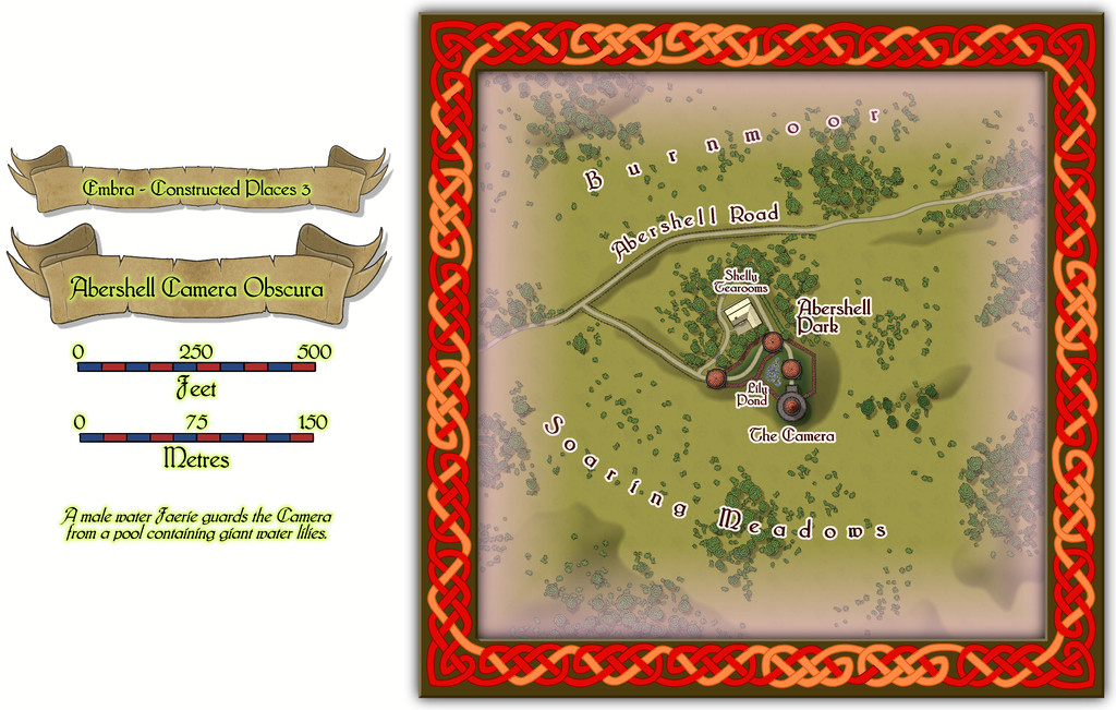
As ever, despite the random selection of base-maps for this series of drawings, the choice of what went where was solely my own, all of which decisions were made with the aim of providing additional puzzles for anyone trying to explore the city, when working to ordinary (i.e. non-Faerie) norms.
There are just two actual buildings here; the rest are open domes over the paths. Oh, and for those who might be interested, the Shelly Tearooms are famous for their exquisite range of ice-creams:
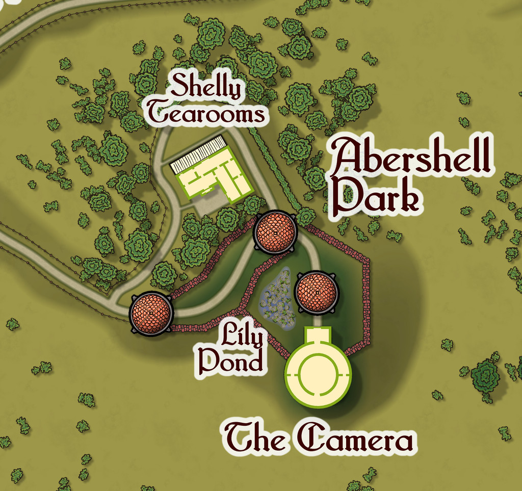
While the Camera shows views of the surrounding scene from its darkened inner chamber, as might be expected, under the care of the featured text's magically-skilled Water Faerie operator, it can show many other things and places too. And when you step out the door, that might be where you'll be. Only if the scene changes, the Camera building won't be there to take you back...
-
Community Atlas: Embra - Hilly Places
Miller Hill as Place 4 seemed an obvious choice for a Hilly site. However, as stated already, y'know, Embra. So this is a water mill at the top of a hill, with a stream that runs uphill to the mill pond on the summit, runs the water wheel, and then descends down the other side of the hill again! Naturally, no one here thinks this is anything unusual - how could the mill run without a water source, is the primary response to those who might seek to question the setting:
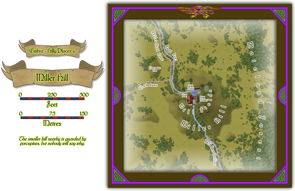
There are some buildings on this map too, for once in the "Hilly" selection, which have interiors that can be viewed using the toggle in the FCW file in the Atlas, all being well:
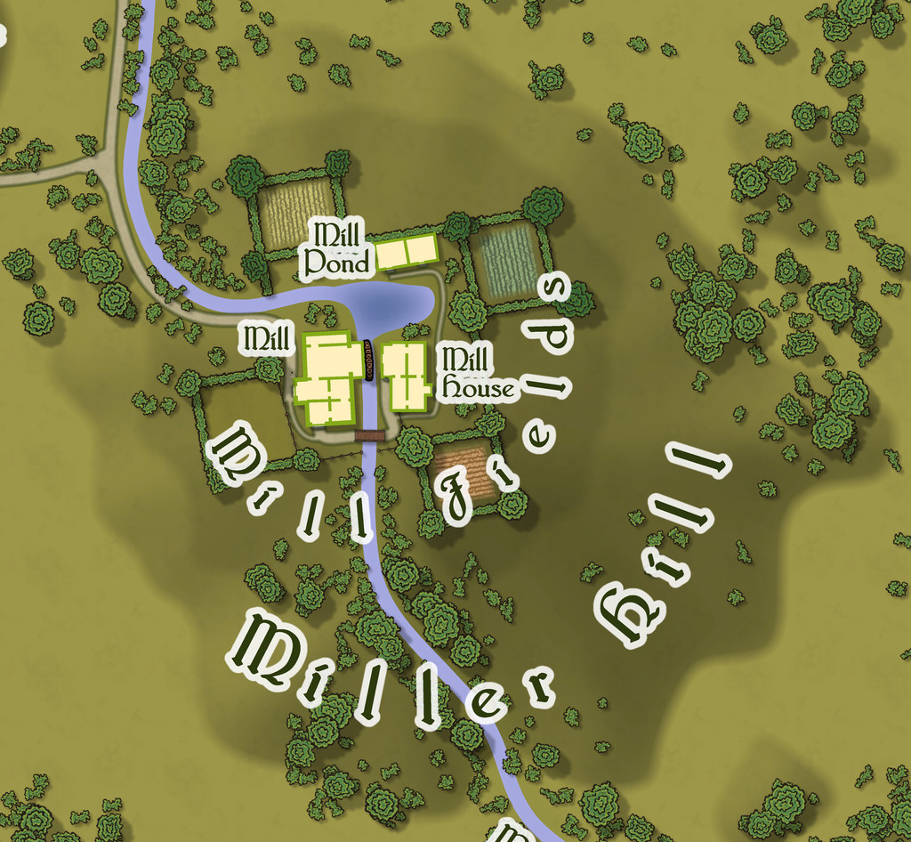
It has to be said I was delighted to see the random base map options had provided one that so obviously fitted the nature of a mill site of this, shall we say unusual, kind - those four square fields looking like the sails on a windmill. So there's a note in the PDF and text files for this map suggesting GMs could have the four fields, and their hedge/fence lines, rotate, flowing over the land surface like cloth, carrying anyone in one of the fields along with them, but only when the wind blows strongly. Everything else of course stands quite still; and not entirely by chance, the rotation centres more or less on the axle of the mill-wheel, where else?
-
How do i know what i currently have installed?
Go to CC3+, find the drop-down menu "Tools" in the bar along the top of the window, and then go to the "Add Ons" label in that drop-down. That will show you everything you have currently installed, and you can click on any one of those names to access each individual item's description in an HTML file.
-
The Expanse rpg; several starships, Annual scifi tiles and Cosmographer
My big problem with large ships is visualizing the layout/deck plans.
I forget whether you mentioned having a copy of any of the Metamorphosis Alpha RPG books or not now Jim, though I suspect from this comment probably not, as even the limited floorplans for the two complete decks, and the brief notes on all the others, in the first edition rules from 1976, would have given you a few pointers in this regard.
In one sense, Remy's right in suggesting it may help to think of the whole ship as like a huge city, actually more like a small country, given its gigantic size. Depending on how you envisage the entire craft as functioning, it's perfectly possible some of the decks might have a single function, or several major functions, each. Something like a farming deck for food production and air recycling, including breeding populations of domesticated animals, for instance, while there could be huge areas given over to parked-up machines on another deck for use on whatever planet the ship eventually reaches to colonise (since that's the primary reason such vast craft were envisaged originally). Elsewhere, there could be factories and machinery for use in them stored on another deck, again to get things functioning once the planet was reached, with maybe one entirely water-filled, for living aquatic foodstuffs, and as a water supply for the ship (could easily be segregated into fresh and sea water parts). Plus power supplies of varying kinds, of course.
It might help to work out what the total floor area is for the whole craft, and then compare that to a populated area on Earth somewhere, and see exactly what sort of features lie within a similar-sized zone, and what of those would be useful/essential on a ship destined to be in space for hundreds of years or more.
Hopefully in all this, we can help get you back on course!
-
Community Atlas: Towards a Solar System for Nibirum
Having been tasked with constructing a Solar System for the Community Atlas world of Nibirum, only a few things were clearly in-place at the outset. Expressed preferences, coupled with the nature of Nibirum as depicted in the surface maps and descriptions of the world itself so far, showed Nibirum to be an Earth-like planet in size and nature, including with seasonal effects and climatic zones, illuminated by a single Sol-type Sun. As noted before, I'd opted for a simplified 360-day year for the planet more or less from the start too. One, probably Luna-type Moon, was preferred at least (Quenten), although perhaps with one or more additional moons (Dogtag). I assumed impressive astronomical phenomena like solar and lunar eclipses would be required additionally, to provide Nibirum with extra flavour and reality. The solar eclipse factor gave a first physical parameter beyond the planet, since Earth-type total solar eclipses could only happen if one of Nibirum's moons had the same apparent size as its Sun.
The "multiple moons" question led me back to an idea I've played with previously in RPG settings, a variable effect or object usually seen in one part of the sky, when visible at all, which can become a convenient plot-device or subject of game-omen lore. I settled on a group of small cometary objects loosely "trapped" around the leading (L4) Lagrange point on Nibirum's orbit. The L4 and L5 Lagrange points on a body's orbit are gravitationally stable points where relatively small objects can become caught for very long periods (centuries to millennia). Their own pre-existing space-motions mean the objects usually continue to orbit about that stable point, so are not necessarily fixed in one spot. Each point lies more or less at 60° from the Sun as seen from the main body - such as a planet - forming one apex of a conveniently equilateral triangle, with the planet and Sun at the other two apices. This means, handily, that the planet's distance from its Sun is the same as the distance to either of these two Lagrange points. One lies 60° ahead of the Sun as seen from, say, Nibirum, the other 60° behind the Sun. Thus objects around Nibirum's leading Lagrange point would be visible close to the ecliptic in the morning sky before sunrise. So these little comets quickly became the Phoenix Asteroids Dawn Heralds.
Leaving the L5, trailing, Lagrange point empty - at least of anything visible from the surface of Nibirum - opens the door to scholarly speculation on the planet by those seeking symmetry. So maybe the misty stars of the Dawn Heralds shine showing the approaching richness (or otherwise) of the magical-mystical potential into which Nibirum will soon be moving (for a 360-day year, 60° = 60 days on Nibirum). That there is no equivalent group of Dusk Heralds could suggest that potential has been exhausted by the passage of the magical world of Nibirum, and will take much time - most of a year, say - to recover.
However, fitting a second, much smaller moon into the trailing Lagrange point on the orbit of Nibirum's main Moon seemed an ideal reworked symmetry, which also gave the planet more than one natural satellite. (The Lagrange point geometry is the same for the lunar orbit. Just substitute "Nibirum" for "Sun", and "main Moon" for "Nibirum" and "the planet" in the earlier description.) Thus was born the Red Moon, always faithfully following the larger White Moon around the sky. Not quite Gloranthan, though with names ultimately inspired by that fantasy world, via the old "White Bear, Red Moon" board wargame name, later revised as "Dragon Pass". Still more perfectly, and following from typical Earthly precedents of similar celestial behaviour, this can also be called the Dog Moon. So naturally, another name for the White Moon had to be the Q Moon (only from Nibirum's southern hemisphere, however, and then only by societies that recognise the significance of the apparent pattern forming said letter on the lunar disc).
Then 'twas time to see what else lay beyond Nibirum. There are of course numerous random solar system generators available for RPG use. Given the experimental nature of the whole Night Sky for Nibirum concept, I decided on one I've had for a while, but never used this way before, Galactic Baroque's "Instant Universe" (available for purchase via DriveThru RPG). This proved interesting, if not quite so straightforward, rapid, or complete as its name might imply.
Needing a Sol-like Sun, and given there is some scholarly debate still as to whether Earth's Sun is spectral type G2 or G4, I went with a class G3 sun of standard stellar type for Nibirum. That means it has sunspots from time to time, and a solar wind able to produce polar and sometimes mid-latitude aurorae, just as we see from Earth. At one solar mass, it seemed sensible to also go with a similar size to our Sun, thus Nibirum's Sun has a diameter of 1,400,000 kilometres (Sol's is 1,392,530 km; if you want miles, divide by 1.6).
Dicing on the Instant Universe tables provided the System with seven planets, their distances from the Sun, masses, sizes, natural satellites and so forth. Some of these features were slightly reworked or rounded-off to give a Solar System a little less mathematically-challenging for GMs to work with, and a few parameters not given by Instant Universe were added. The obvious place to fit Nibirum into this scheme was as the third planet outwards from the Sun, because that had a rounded distance of 130 million km, not far from Earth's own circa 150 million km.
Next came a series of calculations to find out what of all this could be seen from Nibirum. The Sun has an angular size of 0.62° from the planet (Sol is about 0.5° as seen from Earth), so that decided what minimum angular size the Q Moon needed to be to produce total eclipses for Nibirum. A diameter of 2,130 km at 200,000 km from Nibirum did the trick, with an option (just like for Earth) to have the lunar orbit's centre be slightly offset from Nibirum's centre, so the lunar disc can be sometimes a little too small to completely block the Sun, producing not-quite-total annular eclipses occasionally. Random rolls came up with a Dog Moon size of 350 km, so showing a tiny, faint, red disc about 0.1° in diameter as seen from the planet. The human eye can resolve objects as small as roughly 0.07°, so this is quite near that limit. No other planet appears as anything other than a bright to extremely brilliant star to the unaided eye from Nibirum.
I wanted the Dawn Heralds to be quite easily visible sometimes from the planet, despite no individual object within them being brighter than a 3rd magnitude star - and that only very occasionally. So I decided on them appearing as a somewhat nebulous patch, with at most a few brighter (4th or 5th magnitude) star-like points within, which collectively should be roughly 0.5° to 1.5° across as seen from Nibirum. This equates to a physical cross-sectional area of around 1 to 3½ million km or so, an actual size easily achievable by one quite modest comet of the kind visible from Earth. Such an angular size is similar to that of the Earth-visible Pleiades star cluster of 9 or 10 mostly 4th and 5th magnitude stars in the constellation of Taurus the Bull, about 1° east-west by 0.7° north-south. Despite the relative faintness of its stars (only one is 3rd magnitude), this cluster is a surprisingly easy object for the unaided eye in even quite strong twilight. The proximity of the stars to one another seems to make it easier to spot than just their brightnesses alone might indicate, so the Dawn Heralds can have a similar ability to "tickle" the vision of Nibirese morning sky-watchers.
Choosing what to depict on maps from all this, and how to do so, was somewhat more of a challenge. As I don't have Cosmographer installed, mapping came down to a choice between two main Annuals, CA 22 (October 2008) Star Systems or CA 80 (August 2013) HighSpace Star Systems. CA80 has a greater range of planet symbol options, and I needed two ringed planets, but in the end, CA22 just won out, as despite it having no ringed planet symbols, it did have the option for dynamic lighting effects on its planetary discs. Moreover, CA22's Mapping Guide includes a short tutorial on creating your own planet symbols with said dynamic lighting.
Thus with help from the GIMP (with which I freely confess I am a veritable novice), and still more from the Great and Powerful Monsen (who kindly allowed me to extract from his rotating-world graphics, and provided new, FT-generated, north and south polar views of Nibirum for the purpose), I constructed a small group of dynamic-lighting Nibirum planet symbols for use with the Atlas, one set showing six views of just the world, the other half-dozen onto which I GIMP-added some airbrushed white cloudy shapes, to make it look a little more homely.
[Image_10639]
After further deliberation, I decided on one chart to show the relative sizes and orbital distances of the planets, and a set of maps to show the satellites and features for each planet.
The relative-scale Solar System chart:
[Image_10640]
The five planet and satellite description maps:
[Image_10641]
[Image_10642]
[Image_10643]
[Image_10644]
[Image_10645]
Many of the details provided on these maps (collected with some further notes in a PDF to accompany them in the Atlas) cannot be discerned from Nibirum. However, I decided to preserve everything that had been randomly rolled or otherwise chosen, partly for the sake of completeness, partly because in some fantasy settings, there are ways of travelling to other planets - the classic sailing ships of the stars in some earlier incarnations of D&D, for instance. It seemed thus a useful adjunct to include this information for any who might wish to explore the Nibirum system more fully.
After that, I constructed some extra charts to help RPG GMs especially keep track of what's visible, where and when in Nibirum's night sky, starting with those Moons.


