

Community Atlas: Monseignor District in Kentoria
 Wyvern
🖼️ 293 images Cartographer
Wyvern
🖼️ 293 images Cartographer
As I noted after completing my Dendorlig Hall project last October, I'd hoped to have returned to my Alarius mapping by now. Other matters intervened however, and are liable to persist through at least the first quarter of this year too, so I thought it worth trying some smaller mapping projects for a while instead. Partly, this came about following discussions with a few folks on a Discord regarding what to do about possibly continuing with the Dungeon23 concept this year, given almost no one had persisted all year with that, and few had accomplished anything like what they'd hoped for it.
The concept I have for myself currently is to try to map a small dungeon or area each week or so, which, although probably impractical in the long-term, does provide a focus of sorts. Those I complete will all go into the Community Atlas, and following my normal preference for some element of randomness about such Atlas creations, I decided to use the Inkwell Ideas dice sets to generate the base maps in all cases.
For those unfamiliar, the Inkwell dice sets are packs of themed, over-sized, six-sided dice (D6s), where each face has on it a different geomorphic dungeon or cavern drawing. The packs contain either five, six or eight such D6s, and there are currently 12 packs available, three of which are overground settings, nominally "Villages", "Cities" and "Ruins", although the "Ruins" dice are duplicates of the "Cities" ones, where parts of the design have been wholly or partly destroyed. Twelve packs, you say 😁? As in months in a year...
By using random numbers, and selections, of dice from each set, I've generated 52 individual hand-drawn maps based on what the dice provided, which designs were then randomly allocated to places on Nibirum for which regional maps existed in the version of the Atlas I'd most recently downloaded, albeit from earlier last year. The ultimate placements for almost none have been finalised yet, as I'm opting to identify specific locations for them only as I'm progressing. So far, things may turn out to be more complex than I'd hoped, as it may be additional smaller area maps will be needed for many of these along the way too, to define more exactly where they are.
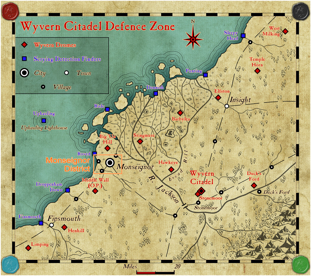
However, the first small map and its new area map are complete, and have been submitted for the Atlas, having oddly enough landed by-chance right into one of my own area maps, the Wyvern Citadel Defence Zone on Kentoria!
Although actually prepared in order of dungeon first, then overground, when going into the Atlas, this situation of course is reversed, so the general area the dungeon was to end up in has first to be identified, what became the Monseignor District map, whose placement was to be here:
That area now looks like this, in more detail:
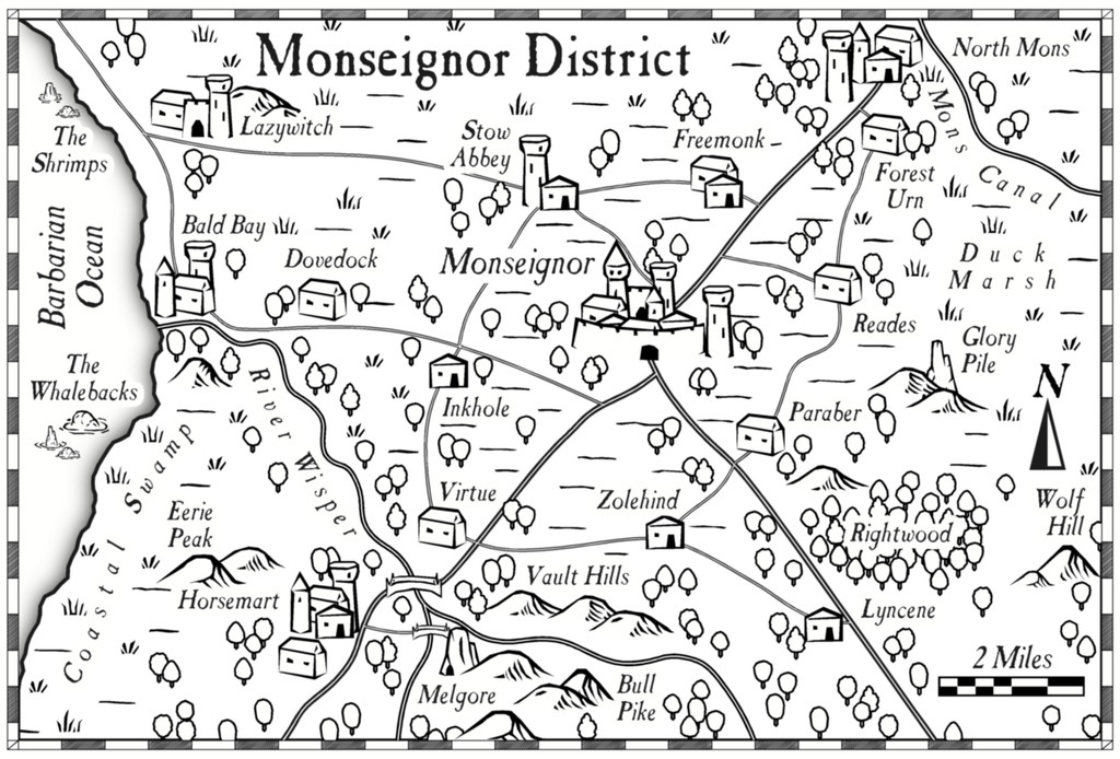
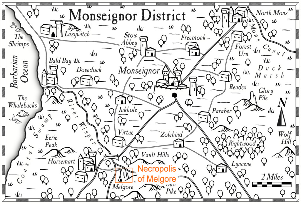
Or at least it does using the Overland Black & White style from Annual 20. Most features had already appeared in the earlier larger area map, or its description, although now some semi-random names and features could be added to those previously unnamed and not shown. Plus of course, the location of the dungeon map had to be provided as well, at Melgore:


Comments
The reason I opted for a monochrome style for the overland map was that I'd already chosen the Annual 48 Dungeon Black & White style for the underground map. Even if technically, it's not truly underground at all, as it's set into the gigantic dolerite mesa-like rock pillar which is what's actually called "Melgore", with its entrances at surface level on the north side of the pillar, by the rocky beach leading down to the nearby River Wisper, and which extends up into the pillar a short way (a total of less than 40 feet, 12 metres, given the pillar is roughly 500 ft tall, 150 m). Thus the Necropolis map:
There are, of course, PDF and text descriptions for both maps to go into the Atlas, to provide more flavour and notes on what's where, and what's going on in both. Some of these ideas came from various random design lists, published and personal, although I also drew on inspiration from the book description available from Inkwell Ideas for the "Crypts" dice set used to create the Necropolis map, adapted and amended somewhat here.
Plus the original dice-map was amended, to remove unnecessary blind passages that didn't link together, and to stop the whole from having too much of a "geomorphic dice edge" look in places. In other sections a few new features were added - corridors or rooms extended, shortened or linked, with new doors or secret doors added as well, as my thoughts about what was here developed during the whole mapping process, much as normal.
I wasn't sure at first about leaving the wall shadows visible into the surrounding rock, although this is what the style was designed to show. However, I became quite attached to this look during the mapping, which, with the crispness of the style, gave me the impression of looking at a map set into a sheet of crystal-clear glass. I did a brief experiment with a wall mask to hide the shadows in fact, as part of the process in concealing the bits of the grid that weren't needed, but found that hid too much of the wall lines, and made the whole thing look rather flat overall.
Higher-res copies of both maps are in my Gallery as well, for those wishing them.
My intention is to keep trying out different mapping styles during this project, albeit I am inclined to attempt to retain a stylistic theme where two (or more) maps need to be nested into one, as in this case.
If all goes to plan, I'm next heading off to a continent that's eluded me till now - the tropical heat of Kumarikandam!
@Wyvern , what exactly are these dice maps. Can one get them online, and are they actual physical dice, or online dice. The concept sounds interesting. It would be nice if you screenshot some of your dice rolls, to see what actually is generated. I would love to use this method for my own world in various places.
The maps are now in the atlas. Thanks for the contribution @Wyvern
Thanks very much Remy!
Since I've had a couple of queries about the Inkwell dice sets outside the Forum, and to clarify for those interested here, the simplest solution is to visit the DungeonMorphs page of the Inkwell site. As you'll discover there, the designs are available also as cards and fonts, and there are books with descriptions and ideas for the more recent sets as well.
In addition, and because I think he actually started the whole concept of geomorphs with this ten-space design (that's ten spaces per side on the design), it's worth looking at the past postings on Dyson Logos' blog, as he's provided illustrations showing many - now maybe all - the designs he's produced over the years, including those he's done for Inkwell. There's a "Geomorphs" tab under the "Navigation" sidebar on his blog, but that only covers the 100 designs he did for a personal challenge in 2009-2010, all collected for easy download in one place. Using the "Post Categories" search box, the Geomorph Mapping Challenge has 217 blog entries, which goes WAY beyond those he's been commissioned to do for Inkwell and those 100 earlier maps!
Thanks, @Wyvern Just what I wanted.