


Loopysue
Loopysue
About
- Username
- Loopysue
- Joined
- Visits
- 10,413
- Last Active
- Roles
- Member, ProFantasy
- Points
- 10,161
- Birthday
- June 29, 1966
- Location
- Dorset, England, UK
- Real Name
- Sue Daniel (aka 'Mouse')
- Rank
- Cartographer
- Badges
- 27
Latest Images


-
Live Mapping: Roof Shading
This week in our Live Mapping session we have a special treat for everyone. Ralf will be examining the roof shading options in City Designer 3 and demonstrating how you can create your own roof-shaded symbols.
Come along and join us live to ask questions or make suggestions here:
https://www.youtube.com/watch?v=E2zoaQqTRAo
Or you can watch it later here on the forum:*
*This thread isn't monitored during the show, but is a place where you can discuss the topic or ask further questions before or after the show.


-
Live tutorial suggestions
I can't confirm or deny anything at the moment. I'm just the artist in the team, but if you think about the difference between CC3 and CC3+ a full set of tutorial vids for CC3 wouldn't cover half of what CC3+ can do in it's current form. You could update here and there, but it would be piecemeal and possibly slightly confusing as the series jumps between the two versions - no longer as coherent and simple to understand as a complete set of new vids.
-
Live tutorial suggestions
@RetailPleb I think the shape of what you are asking for there may be some kind of 'Encyclopaedia of CC Mapping' (based on the Tome of Ultimate Mapping and all of the 220+ Mapping Guides) in numbered parts that includes not just the core app but every part of the software. That's quite different to the hour long friendly mapping sessions we call Live Mapping, as the Tome has 754 pages, not including the appendix or index.
Ideas like this are nice, and I think most people would agree that it would be an excellent thing to have such a set of reference videos, but as most who have attempted it in the past have discovered there is just so much of Campaign Cartographer when you include all its add-ons and annual issues that actually doing it might be an impossible task.
We also have CC4 in the making, so anyone that completed such a heroic task would have to do the whole thing all over again - if they succeeded the first time.
...
EDIT: Visualising this for some reason recalled a memory of having to watch a 3 hour instructional video on how to use Affinity Designer that covered pretty much everything I've ever used in that app. I was exhausted, and have never forgotten the experience - something a bit like helpful torture.


-
Maximum MB in use?
Cities are well known for it.
While I can't explain all the technicalities involved there, I can suggest a few tips on how to cope with it.
In addition to reducing the resolution, you could also try 1 or more of the 3 options available in the Shading panel of the Display Settings dialog.
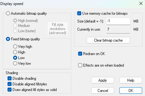
If you work on one sector at a time you can put all the other sectors on different layers and then hide them, though they might be on the same sheet.

-
Live tutorial suggestions
No worries. Blogs tend to get forgotten these days. I forgot all about these two myself.
