


Loopysue
Loopysue
About
- Username
- Loopysue
- Joined
- Visits
- 10,414
- Last Active
- Roles
- Member, ProFantasy
- Points
- 10,161
- Birthday
- June 29, 1966
- Location
- Dorset, England, UK
- Real Name
- Sue Daniel (aka 'Mouse')
- Rank
- Cartographer
- Badges
- 27
Latest Images


-
Creating greater depth
I think you are doing well with the contouring. It does take some time and patience to get it right. Roads are a tricky one. I did a city a long time ago and cheated a little bit by using 6 or 7 tiers a bit like a disorganised wedding cake. That way each tier cast a shadow where necessary over the roads and houses on the tiers below.


-
Live Mapping: Connecting Symbols
Hi Everyone :)
This week, Ralf will be showing us how to make connecting symbols using the November issue of the 2007 Cartographer's Annual.
Hope to see you there! :D
![[Deleted User]](https://secure.gravatar.com/avatar/c75d9a245b74d9c59be0999ea81ca541/?default=https%3A%2F%2Fvanillicon.com%2F92add7f8c954488718110edc4896ad39_200.png&rating=g&size=200)


-
Non-Facebooker: am I missing good PF stuff?
Now that uploading larger images here (several times larger than you can on FB) is possible, and with equal ease, I mainly visit the FB Group to help new users and test the water with new ideas.
When I post a map I post in both places, though I usually run better WIP threads right here on the forum where I can always find my stuff. I don't waste time trying to find and continue old FB posts, so the information there is bitty and all over the place compared to here.

-
Live Mapping: Using FT3+ continents in CC3+
Hi everyone! :D
Following from some ideas in last week's live mapping session, Ralf will be looking at using Fractal Terrains-generated material in CC3+ overland styles in tomorrow's live mapping session.
Come along and join in the chat here:
https://www.youtube.com/watch?v=iqW-kQ7cC60
Or watch it here if you prefer, though there's no live chat on the forum.

-
FT3+ to CC3+ export with style?
When you export your file there should be a small range of styles you can pick at the top of the list. At the moment these appear to be the core styles plus 'Jerion', which I think you may already have used.
This is FT3+ by the way. FT3 doesn't have these options.
I think there might be a way to add to that list, but I'm not entirely sure how it's done.
-
August Mapping Competition - Building Floorplans - Win Prizes
I'm late! Oh dear.
I'm also pretty crazy, so I've picked one of the largest remaining buildings - the Town Hall and Tax Office.


-
Is CA46 Castle Walls still state-of-the-art?
Yes, all the annuals work with CC3+ because they were updated to do so. (If you should find an exception to this rule please contact Tech Support).
Unless there is a style of a similar name with the additional word 'revisited' included, then the one you have is likely to be the most up to date version of that style (or toolset). To the best of my knowledge there isn't a 'revisited' version of that issue.
-
How to Represent Elevations in a Top Down DD3 Map?
Using sheets is probably the best way if you are quite happy to draw the shaded extent as a polygon shape.
The global sun only affects:
- how CD3 buildings are shaded, and
- which direction the shadows fall from objects on sheets with Wall Shadow, Direction sheet effects.
It doesn't affect the artificial shading you add using a sheet with black polygons on it. That sheet might have a Blur effect, and then a Blend Mode effect that is set to multiply. Transparency is controlled from within the Blend Mode.
---
An alternative that isn't quite so flexible is to use a Bevel Lighted on a sheet on which you then draw polygons of texture or one of the semi-transparent fills. If you adjust the bevel to a huge width and use masses of smoothing you can get recognizable hills. However, the width of the shading won't vary.


-
WIP Commission, Ancient Tombs
On that last point, Raiko, I think there might be an issue if Jim is using the app for commercial purposes. The license is quite specific about it in the first paragraph under "DESCRIPTION OF RIGHTS AND LIMITATIONS".
However, it is not Profantasy's intention to be obstructive to the enjoyment of their software, so it is probably worth making polite enquiries via Tech Support to find out exactly how this rule applies to your particular circumstances and the issues you are having, @jmabbott


-
The Lakes of Michigami (Jerry's Map) - WIP thread
I've roughed out the rest of the map and added a new title from Jerry. There have been a few name changes. I'm still working on the rivers - tapering them and tidying the ends.
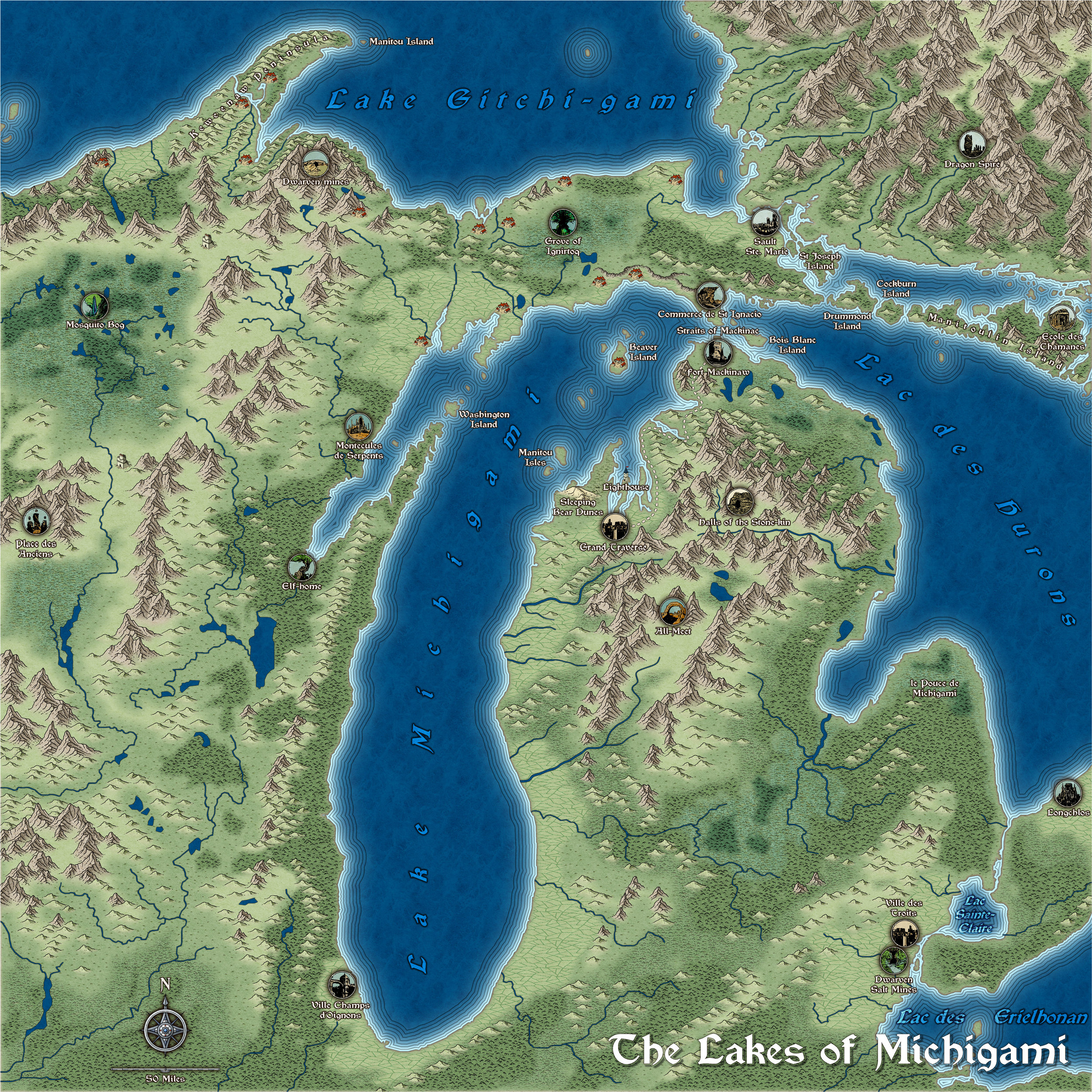
@GThiel - Jerry, please let me know if I have forgotten anything, or if you want anything changed from the way I've done it? Thanks :)

