


Loopysue
Loopysue
About
- Username
- Loopysue
- Joined
- Visits
- 10,416
- Last Active
- Roles
- Member, ProFantasy
- Points
- 10,161
- Birthday
- June 29, 1966
- Location
- Dorset, England, UK
- Real Name
- Sue Daniel (aka 'Mouse')
- Rank
- Cartographer
- Badges
- 27
Latest Images


-
Winter Village style development (March 2022 CA issue)
@Shessar - I think you are probably right about the rafters, and thank you :) I think I remember a map you once did where you were trying to create a snowy scene not a lot unlike this one. Its been in the back of my mind for a while now ;)
@JimP - yes, that's definitely more of a spring theme than a winter one, but I know what you mean. Towards the end of the last inch of snow we had here it hung around in the shade for at least 2 weeks longer than it did in the sunny places.

-
Winter Village style development (March 2022 CA issue)
Thank you very much, Jeff :)
Once again the ridges are nearly exposed, but I think that in order to keep the tiled houses interesting I will have to assume that the snow of Winter Village is not so dry, and expose a little more than that.
DoubleDouble - this is very true, but unfortunately I can't predict which way around any of the houses will be pasted, so I will keep the coverage about the same on both sides.

-
Lakes and Rivers disappearing, tried a bunch of tips from other forums, but it is still happening.
They really are below the landmass.
The sheets are in the order in which they are rendered, which means the RIVERS sheet is rendered before the LAKES sheet, and both are rendered before the LAND sheet. Move the LAND sheet up to just underneath the NAVIGATION LINES sheet and you should be ok.

-
WIP Everyone's making Inn's & Taverns - making floor look used / abused
That's pretty good :)
The only problem I can see is that the furniture now looks too perfect compared to the floor.

-
Discord Server
I don't do Discord. I like helping people, but having to explain everything every single day all over again for the rest of however long I am able to help simply doesn't appeal. Forums are better repositories for knowledge. That way I only have to write one good response and then I can refer to it after that, meaning that I have time to make new art as well.
-
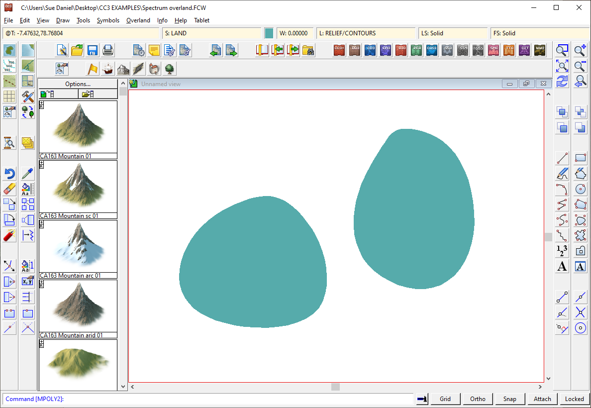
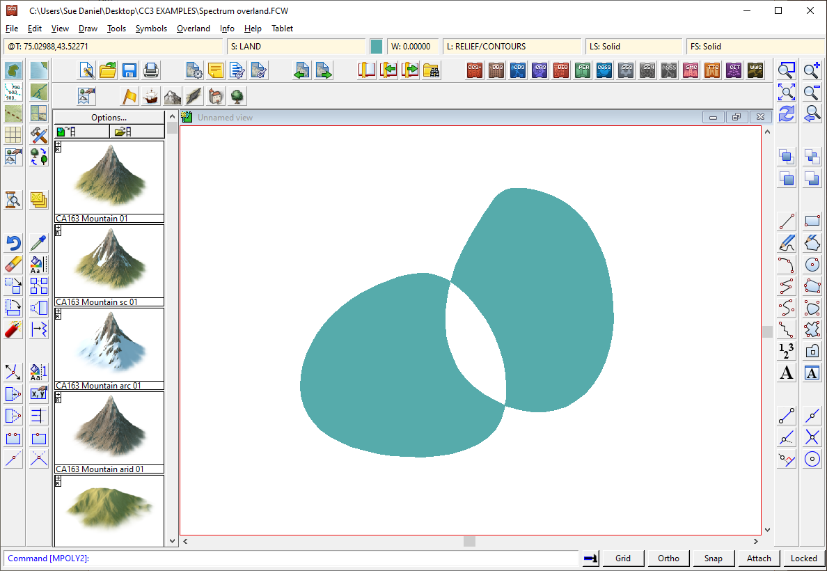
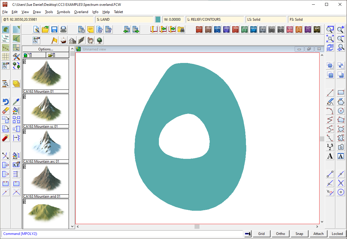
Merging polys -- how?
Use the Multipoly tool |CC2MPOLY2| to combine them into one shape.
Two smooth shapes with different properties.
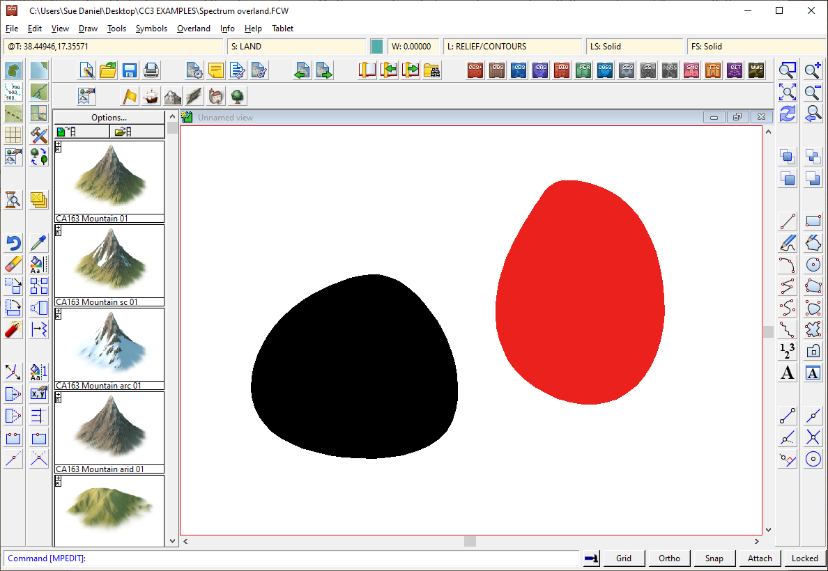
As long as they aren't touching, all shapes will be preserved as they are, but multipoly will make them behave as if they are one shape and impose universal properties on them. These two solid shapes took on the green colour picked in the palette and active in the Status Bar at the time the multipoly was created.
If they partially overlap you will end up with a hole where the overlap is.
If one lies within the other, the smaller inner shape will become a hole in the larger shape.
You can change the properties of a multipoly, but you can't edit the shape or trace it. To do either of those things you have to explode them again using the Explode button, which can be inconvenient. Unless there is a good reason for using a multipoly (for example, if you need to be certain that all the land of a global landmass will be affected if you change properties by picking once on any part of it), I recommend leaving the polys as they are - separate.
-
River Channels with FT3+
Yes, but it's easier if you export the map to CC3 and edit them as vectors.
If you are exporting the map direct from FT3 and not using CC3 at all, and the problem is that you ran Rind Rivers with settings that didn't give you what you wanted, you can Clear Rivers, and/or Delete River Overlay and try Find Rivers again with longer rivers at a higher resolution (resolution is controlled by increasing the Editing resolution in the World Settings). It's much faster than hand editing.
To get an editable raster image river overlay you need to check the 'Keep River Overlay' box when you initiate the Find Rivers tool, and then open the overlay window and make it both visible and active.

-
FT3 and Wilbur
More or less at a world scale, but probably not if you zoom in to the map. That's because the noise used to roughen the surface prior to the erosion will be different each time. So the difference is in the fine details.
FT3, while capable of working to very high resolutions, can't match the level of detail you might achieve in a regional area in Wilbur, but you can help by setting FT3 to maximum editing resolution before you burn the imported data into the surface.
-
WIP Everyone's making Inn's & Taverns - making floor look used / abused
Oh yes - the furniture looks much more like its been battered around.
Arrow slits would be an interesting change from the norm, but either way.
Have you thought of making the walls pop a bit more by playing with the sheet effects on the WALLS and FLOOR sheets?
-
River Channels with FT3+
Create rivers in the normal way (Tools->Find Rivers) and tick the checkbox called 'Keep River Image Overlay' on the dialog that opens once the rivers have been calculated.
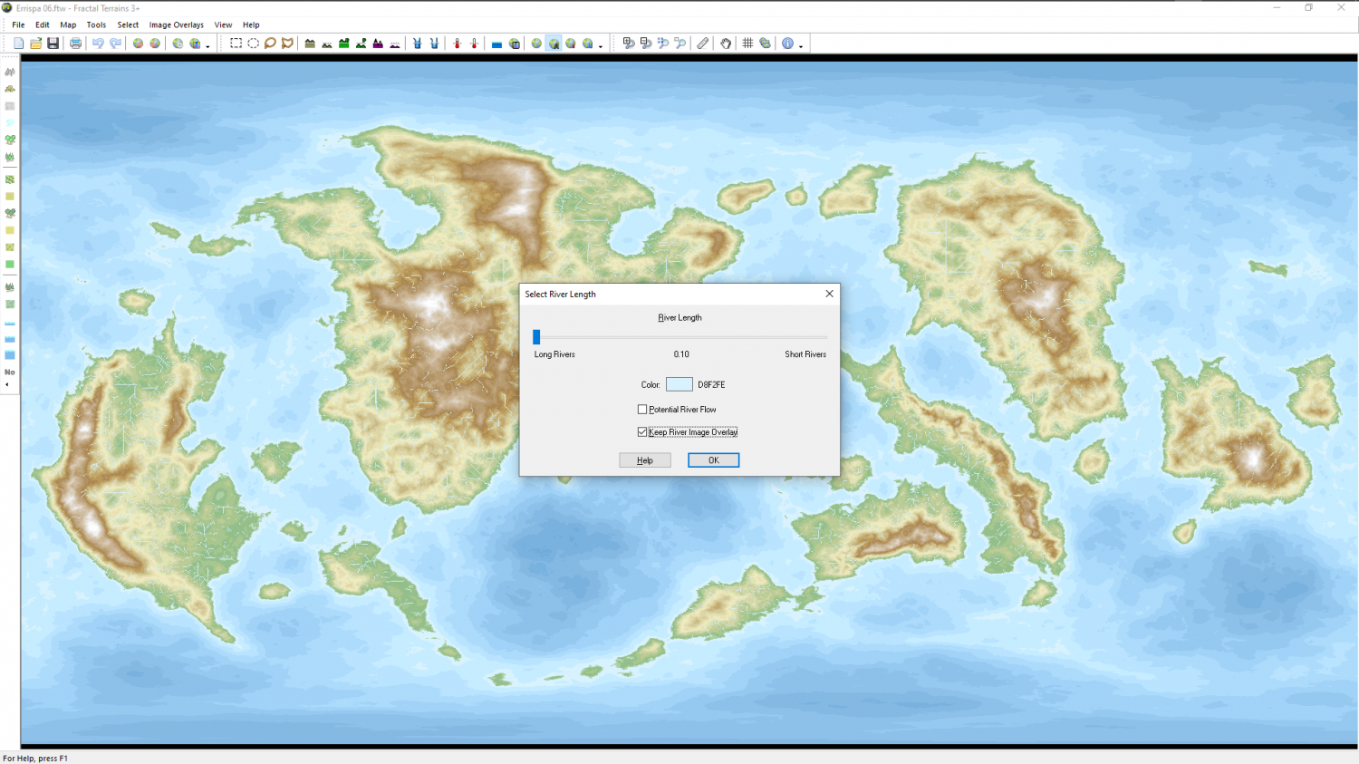
Once they are done, you can show the generated river overlay and edit it. This is not the same thing as the vector rivers already visible on the map.
And the only way to find the limits is by trying them ;)
I recommend running through the One Day Worldbuilder, which is included with FT3. That will allow you to take the FT3 world to a free app called Wilbur and bring it back to FT3 with decent river channels nicely eroded in the land. Otherwise you will probably end up with a mass of rivers so dense that the whole map is blue. This is what happened to me when I tried pushing everything to the absolute limits just now. I would say that is down to the lack of suitable channels.

