Loopysue
Loopysue
About
- Username
- Loopysue
- Joined
- Visits
- 10,418
- Last Active
- Roles
- Member, ProFantasy
- Points
- 10,163
- Birthday
- June 29, 1966
- Location
- Dorset, England, UK
- Real Name
- Sue Daniel (aka 'Mouse')
- Rank
- Cartographer
- Badges
- 27
Latest Images


-
Advice for planning a major city?
That's unusual. Generally speaking, if you have a very large city vector symbols like House entities and some of the more complex vector symbols the node count gets rather large and causes things to slow down.
Either way, an extremely large city will be slow, but you can put your districts on different layers and hide the ones you've finished already while you are working on the next one.


-
Forum vs Product Registration
Incidentally, there is currently an unbelivable Humble Bundle deal for the whole caboodle at the price of a single Cartographer's Annual.

-
Snap issues
There are a lot of settings or variations of the basic commands that you can modify by right clicking the buttons. Check them out and see :)

-
Cartographer's Annual 2023 broken zip
Have you tried a fresh download? Maybe this is a recent download anyway. If so, please contact Tech Support for assistance, Steven.

-
Compass Roses
If you import a symbol at a scale of 20 pixels per map unit, it doesn't make any difference what the dpi is of that image. It might be 72 or 600 dpi. It really doesn't matter, because it will be 20 pixels per map unit in the map.

-
I've made my symbol tray too large
Right click once on the symbol tray to expand or collapse it.
Looks like you hit a right click on it without realising ;)
-
The Cartographer's Vault Humble Bundle
@camilodiezr The Cartographer's Vault bundle contained some lovely maps drawn by a range of fantasy artists (including Alyssa Fadden), either in other apps or by traditional means. Those maps are not included in the current bundle.
@ZigZaw The help files are sadly not in good condition, but the User Manual has all the basic information in it. You also have the Tome of Ultimate Mapping in that bundle which contains nearly everything there is to know. I recommend using that only as a reference manual, though, since I don't believe anyone has ever managed to 'work through' it's 750+ pages.

-
Have any of you ever printed your maps?
Plenty of people have, but not me. I also tend to design new styles more for screen appreciation. They aren't particularly printer friendly, though Profantasy have printed a couple of my example maps for display at Gen Con. They turned out really well, but were probably quite expensive.

-
Live Mapping: Fun with Hotspots
This week in live mapping, Ralf will be teaching us how to hide easter eggs on a map and how to set them up for the hunt (using the hotspot and macro functions of CC3+).
Come and join the hunt live on Youtube here:
https://www.youtube.com/watch?v=wRX2UwzSW1M
Or if you prefer you can watch it here on the forum*
*This thread isn't monitored during the show, but you are welcome to discuss it below.

-
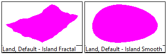
Birdseye cut-out problems
Remember that the land is the background, so you want to be cutting through the water to reveal it as the island. That's where the Color Key is to enable cutting.
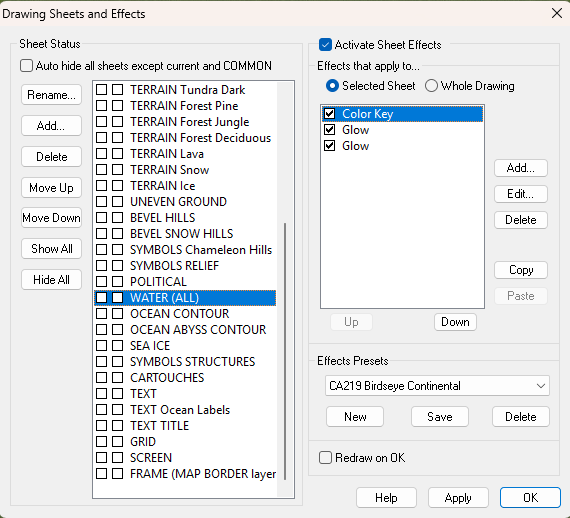
If you use one of these two drawing tools you should be able to draw your island without any trouble, as long as you haven't significantly modified the way the sheets and effects are ordered and set up.