


Loopysue
Loopysue
About
- Username
- Loopysue
- Joined
- Visits
- 10,417
- Last Active
- Roles
- Member, ProFantasy
- Points
- 10,163
- Birthday
- June 29, 1966
- Location
- Dorset, England, UK
- Real Name
- Sue Daniel (aka 'Mouse')
- Rank
- Cartographer
- Badges
- 27
Latest Images


-
Help with lighting
If you haven't already done this, use the EXPORTSETMPPP command to increase the maximum pixels per pass from 4 million to 40 million. The lights are being chopped off because each rendering pass only takes account of the lights within the extent of the pass. Increasing the extent of each pass is usually sufficient to cure this problem.

-
Hi, great to be here from Skillet!
Pst! It's ok Skillet - Remy is Norwegian ;)

-
Change Landmass Borders to different styles?
If you hide or delete the COASTLINE sheet that will get rid of the blue line, which is a separate entity to the land drawn on the LAND sheet.
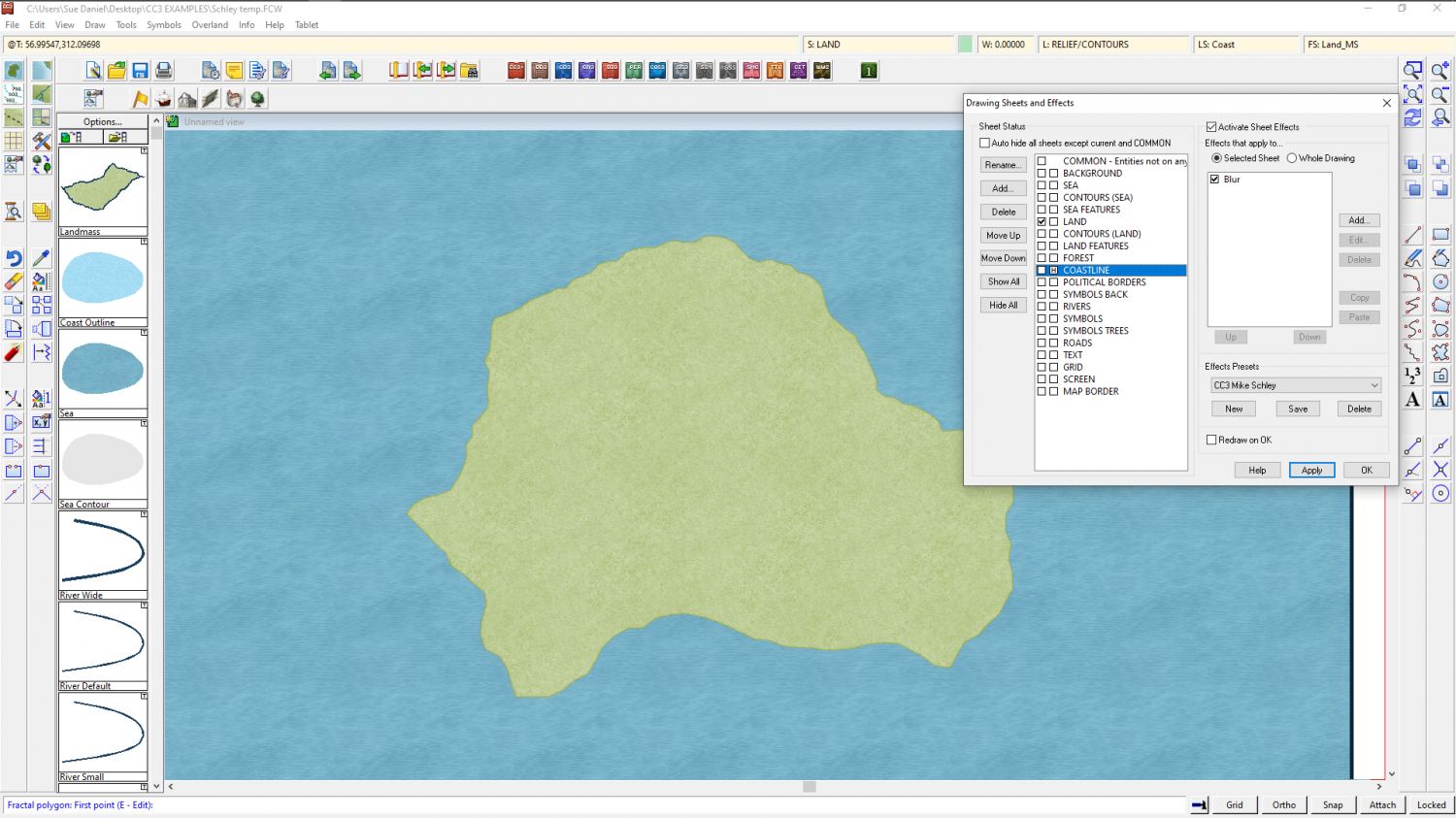
I haven't got a default CC3 style map lying around I can just open, and I'm a little tangled up with 3 instances of CC3 open at the same time right now, but if you click on the LAND sheet of the default style you should be able to copy the sheet effects on that sheet, copy them, and paste them into the Mike Schley map.
As for the rivers - I believe they are drawn the same way in both styles, though the colour might be different. You can find out what colour the rivers are in the default style using List from the Info menu, and then change the properties of the rivers in your MS map using the Change Properties button on the left toolbar.

-
Show All Text Insertion Points
It's not the insertion point, but the baseline of the text. Click on the bottom of a letter and you will see.

-
Show All Text Insertion Points
I think sheets have been around for quite a while, but either the TEXT sheet or the LABELS layer should do the trick - or variations of those two names.
-
Live Mapping: Darklands Annual
Hi Everyone :)
In this week's Live Mapping session on Thursday 6 May, Ralf will be demonstrating the use of the new Darklands Annual, published as this month's issue of the 2021 Cartographer's Annual
Come along and join in the fun :)

-
Too early for a CC4 wishlist thread, or is it timely?
I hate shortcut keys other than CTRL+Z, CTRL+C, CTRL+V and CTRL+S
Those stay the same in any app. Everything else is different between apps, and it's a complete nightmare having to remember them for all the apps I use. Worse, I get the apps confused because they are all black and charcoal these days, so I can waste a lot of time by using using the right shortcut key but in the wrong app.
Give me buttons and menu commands any day.


-
WIP: Cartographer Guild May Challenge
Looking good :)
I think you may have used a bit too much compression on this JPG. I'm getting those nasty little squiggles. 90% is enough. Never ever sacrifice quality for having a file size that is unnecessarily tiny.
-
Hot Water Recirculation shenanigans
If I'd had CC3 in it's current format when I was doing my beach profile surveys for the practical part of my Biology A level back in the 80s, there would have been some pretty spectacular diagrams.

-
Seven Kingdoms map updated
A very tidy map")
Quenten is right about the rivers into the lakes. It's just the one coming out of it and heading for the sea (or the next lake in a string of lakes) that should only be just the one.
I only have one suggestion, and even that is only a matter of personal preference. Please ignore it if you like your maps really tidy, but sometimes forests look a little more natural if they thin out towards the edges. With the effects you have on that sheet, however, creating the thinning out by adding small patches around the larger ones might be a little tricky and could make the map look spotty if you go too far, so it is only a suggestion.
