Wyvern
Wyvern
About
- Username
- Wyvern
- Joined
- Visits
- 3,230
- Last Active
- Roles
- Member
- Points
- 5,507
- Rank
- Cartographer
- Badges
- 24
-
Fractal Coastlines CC3 Hex Overland
-
Issue 199
Thanks Ralf. Just done a fresh download and install over the earlier Monkey
PuzzleFrog Annual, and a quick test check of a couple of drawing tools and symbol groups suggests all is well. While I found no issues with the drawing tools or symbols after my previous installation, as noted before, accessing the PDF now does work fine. -
Galangar - The City of Gold and Red
Looks good.
Obviously, the Empire of the Sun Annual would work nicely for a map of this kind, based on your sketched style, but that wouldn't provide nearly so many building/structure options. For clouds, you might try the cloud symbols in the Alyssa Faden Annual. I'm not sure there are other separate cloud symbol options, although SS6 does have some chimney smoke plumes (they look a bit too smoke-plume specific to be ordinary clouds, however, unsurprisingly!).
Might be worth thinking of moving the mountains further back overall, as they don't look quite right where they are now; too sharp and clear. Maybe add a misty vale in between the building and mountains/trees, and/or just add some mist (transparent irregular polygons of white/pale grey) to fade them a little, and give the impression they're more distant.
-
Issues with Inked Ruins Style: Hatching "Texture" Size and Water Rendering
You're very welcome Eukalyptus! Glad it helped.
Turning off the "Restrict to map border" command was one of the first things I discovered, because it solves so many problems with the effects, such as when you've applied something like an edge fade (or other similar techniques) to a fill, to avoid getting those round the map border too, creating a border within the border, which almost always looks wrong. When I remember now, I usually turn it off in all tools I know I'll be using, because it's just so annoying sometimes. I understand why it's turned on as the default, although for someone who often works outside the technical map border - to add map keys, for instance - aside from with on-map features that don't benefit from a sharp map-border edge - it's a real pain. Appreciate I may not be typical in this though 😊!
-
Switching symbol orientation - Symbol Set 6
-
Mirabar Region Of The Forgotten Realms
Treating the Forgotten Realms setting as a sandbox onto which you can project your own preferences and ideas is an excellent one, albeit I say this as having used exactly this same Mirabar region for starting my own 5e explorations in soon after that edition first came out! Didn't get as far as I'd have liked with it, but I might return to it one day - and this image took me right back to my first mapping in the area as well.
I might make the hex grid a little more obvious is all, if it'll be important to judge distances more exactly, and quickly, during the game.
-
Community Atlas: Dendorlig Hall - A Sort-Of D23 Dungeon for Nibirum
-
Community Atlas: Embra - Crossing Places
There is a boat at the ferry crossing landing on Ferry Road, but it's a sailboat.
Ferries don't even need to be especially boat-shaped, of course, as something like a square plank raft will do, particularly of the kind that uses pull-ropes to cross the watercourse. Some of those types were still in use in places well into the 20th century (notably the more rural areas, and on relatively narrow crossings). Depends what you need, where and when.
-
Sinister Sewers - Style Development Thread (CA207)
-
Sinister Sewers - Style Development Thread (CA207)
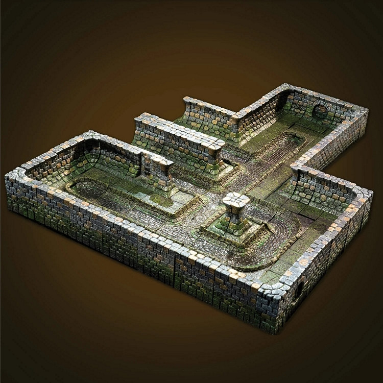
Not a map as such, but the cast terrain company Dwarven Forge do a range of sewer pieces for their "Cities" models, which might provide some pseudo-medieval style inspiration. This link is to their main, fully hand-painted, set, and this is the main image for it:
For ideas on what sewers can sometimes look like, you might care to watch the latter stages of the 1949 movie "The Third Man", or dig through the nearly 100 images relating to it on the IMDb site here, if unfamiliar. Many of the sewer shots were from actual locations under post-war Vienna, although some (notably those with Orson Welles - where you can actually see it's him, as many of his shots were done by a double) were mocked-up/recreated in the studios later.


