


Mythal82
Mythal82
About
- Username
- Mythal82
- Joined
- Visits
- 781
- Last Active
- Roles
- Member
- Points
- 366
- Rank
- Traveler
- Badges
- 3
Latest Images

Reactions
-
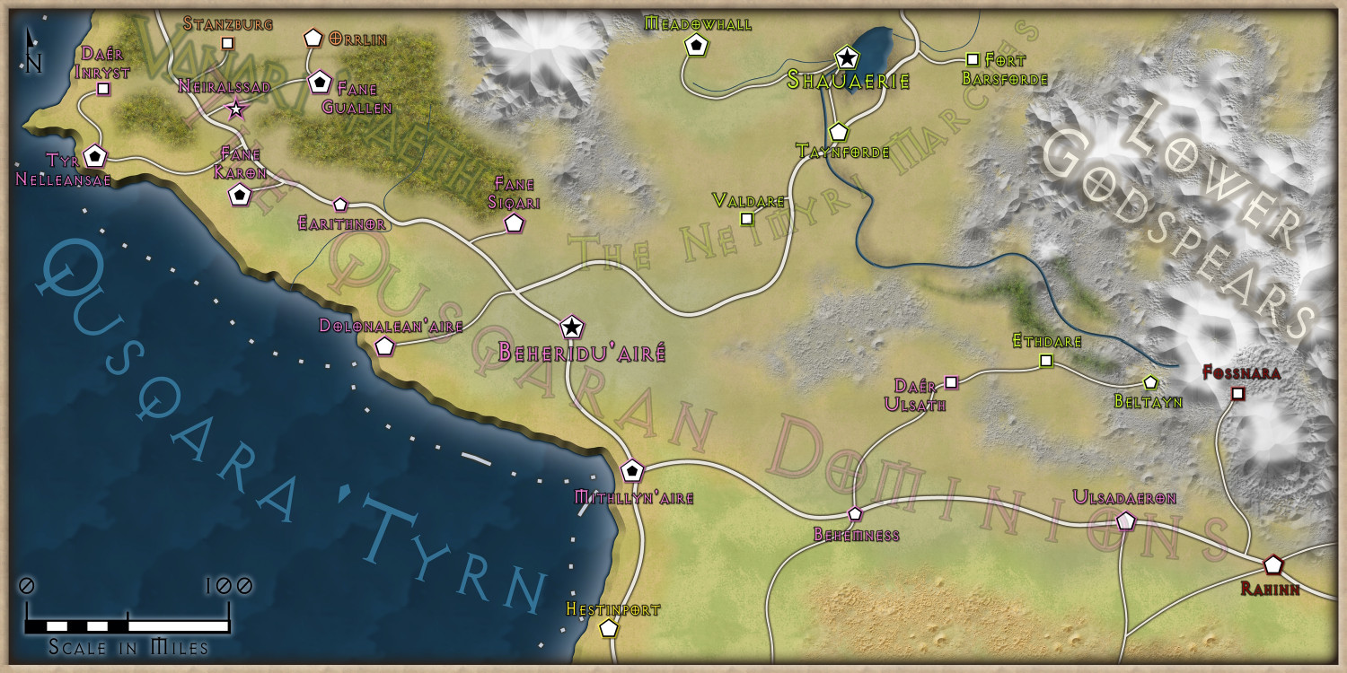
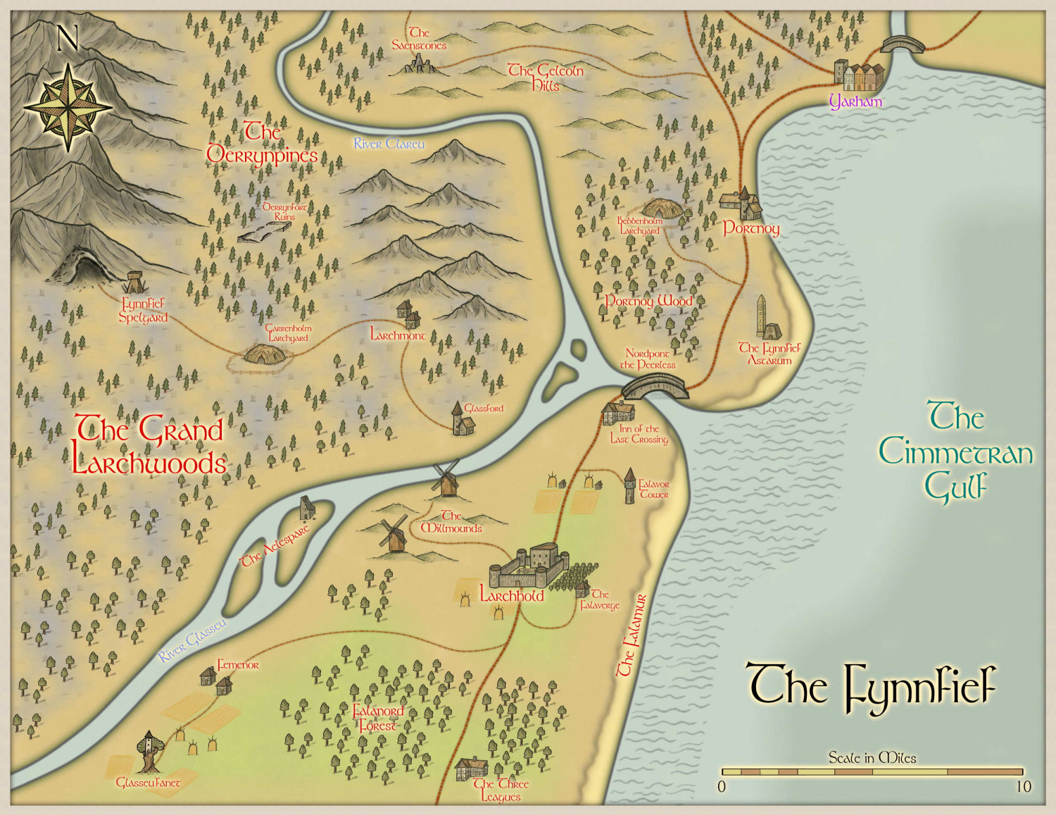
[WIP] Continent Map using CC3+ MS Overland and other resources
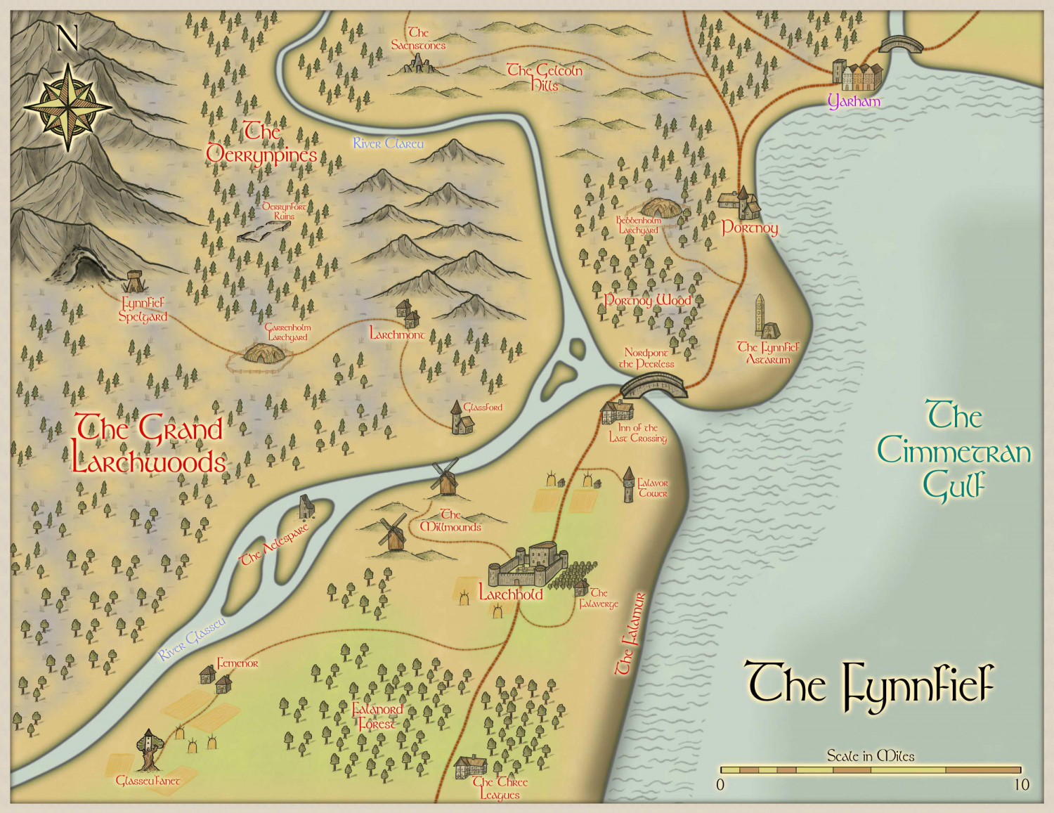
Here's my first attempt at a regional map based on the above Continent. It depicts a tiny (35mi x 27.5mi) region in northernmost Cimmetra (where the yellow country meets the purple country at its northern tip).
A couple of issues I found. First off, the road tools bugged quite a bit, so I wound up just replacing them with splines assigned to the relevant sheets - I think the result works, though. Second, and more of an issue, I couldn't think of any way to indicate on the map that The Falamur is a shield-wall of cliffs - there's no cliff symbol, etc. - so I wound up just using the same technique I've used to indicate elevation in maps before. Does it convey the intent well enough, do you think? Or is there a better way to get this across?
(It's important to the plot - it makes Nordpont the Peerless the only way to move cannon and heavy troops north to south)


![[Deleted User]](https://secure.gravatar.com/avatar/c75d9a245b74d9c59be0999ea81ca541/?default=https%3A%2F%2Fvanillicon.com%2F92add7f8c954488718110edc4896ad39_200.png&rating=g&size=200)


-
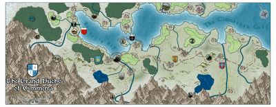
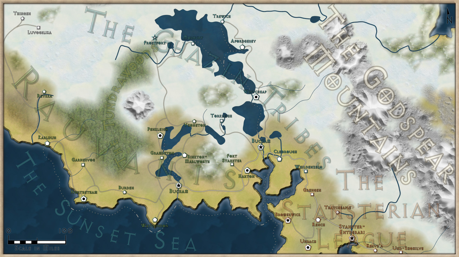
Grand Duchy of Cimmetra: Ancient Realms with Heraldry
So, this is a continuation of the world mapping project I began a few months ago using the 13th Age Revisited style. I took onboard a lot of the suggestions people made for those maps, and one of the regional maps which came out of it was this:
The party's campaign is focusing on Cimmetra, and rather than stick with the broad-brush continental region map, I decided to something more nation-scale, falling back on the Ancient Realms style (which is one of my favourite looks for an overland map). I also wanted to delineate (vaguely) the regions within Cimmetra in terms of heraldry (the players are getting a companion document which outlines the noble houses in question), so I fell back on Cartographer's Annual Vol. 2's Heraldic Symbols style.
Obviously the setting required some alternative/bespoke textures and a little bit of photoshopping to make them work, but I'm fairly happy with the outcome. All in all, it took about a day:
As always, all feedback gratefully received!


-
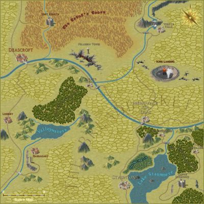
SS6: First Attempt
And, because the heroes need places to go to as well as somewhere to come from, I tried my hand at a Spectrum Overland map of the surrounding area at local scale (25mi across):


-
[WIP] Using Watabou as a basis for a mediaeval fortress town, using the 1930s Street Map Annual
I really enjoyed the Annual issue which explored how to paint over Watabou-generated cities while keeping the general aesthetic of the maps it creates (which are fab), but I’ve always wanted to try my hand at giving one of them more of a holistic makeover. After going back and forth over the best way to do it, and repeated false starts using more detailed Annual templates as a base, I decided that possibly a less-is-more approach was warranted, and made a concerted effort using the 1930s Street Map annual style.
The mapping is mostly finished at this point - I’m now working through the process of identifying the important buildings and swapping them from hatched to solid. It was a bit of a labour of love, but the flexibility of the 1930s Street Map Annual Style, when it came to a Watabou-generated base, was that it bypassed the most frustrating problem I’d found (which was “how to make the building positions and shapes feel natural, or at least not jarringly unbelievable, with so many acute angles on the blocks”); I simply drew buildings of abnormal shape, rather than trying to justify those shapes with extensions and dormer windows.
Would love feedback on the result - does it feel “believable”? Does the aesthetic work? I’ve had to use hatch textures from other annuals for grassland, graveyards and farmland, as the Annual (understandably) doesn’t have those as standard options, and if anyone has better suggestions for these I’m all ears (since they do contrast quite a bit with the Annual’s standard hatching).
I’ve included both the original Watabou-generated base, and my map’s current iteration.

-
[WIP] Fantasy Renaissance River City
To give myself something to focus on in-between trying to make city-scale mountains work, I've started on a more straightforward river city map. It's very much a work in progress, using a Watabou generated layout to give me a base to work from, and then editing it to fit the lore of the game I'm running.
The city will be divided into districts identifiable on the map by the tones of the watercolor textures I'm using for the housing (browns/earthy tones for the industrial area, reds/pinks for the Dwarven quarter, and so on), and the shaping of the architecture. Ultimately the industrial areas will want a more polluted, hard-done-to look. There'll then be shanties and lean-tos outside the city and within the floodplains, where the more impoverished workers and the destitute reside.
All feedback gratefully received!


-
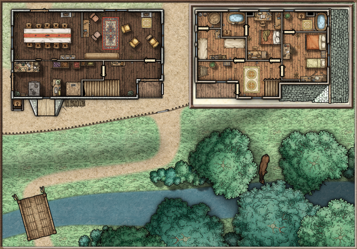
Mallory Steading - Dungeons of Schley Map
Tried something new this weekend and put together a small encounter map using SS4/FC, with the upper storey as a callout map, and the tiles taken from a high-res SS5 output. Whatever lies in the loft or basement for the party to discover is up to the viewer. All feedback gratefully received!


-
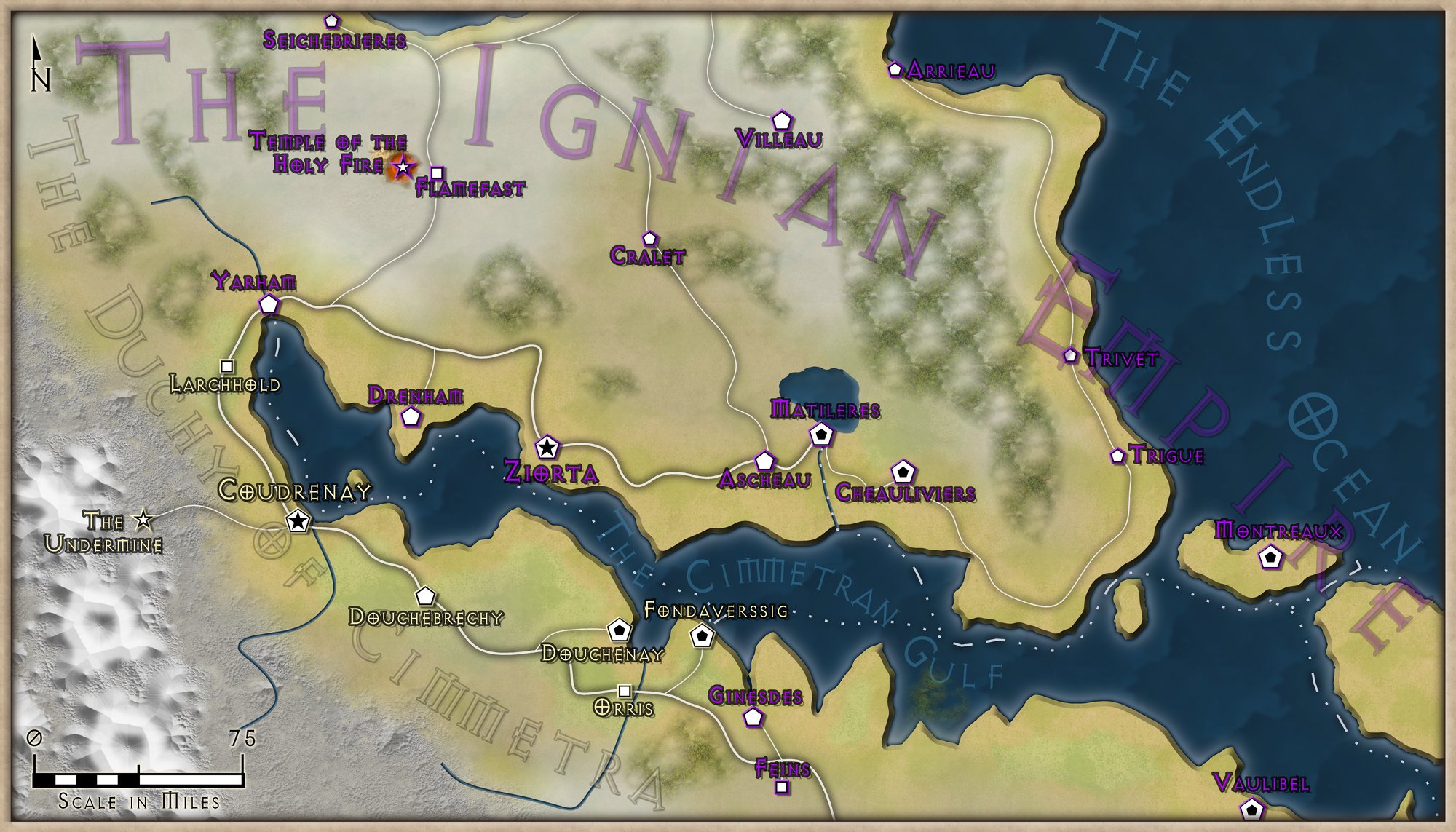
[WIP] Continent Map using CC3+ MS Overland and other resources
So, here's the finished set of maps. I couldn't really think of a better way to include the nation names than the transparent text, but I've tried to make it less intrusive - though it's still slightly 'busy' on the Stansterian League map. And the fractalisation definitely helped the overall look! Thanks so much for the advice, and feedback gratefully received


-
Colourising a textured fill tool
Thanks for this! After a little meddling, following your advice, I've managed to get this working. I've also added a more subtle randomisation to the pitch, which has the added benefit of giving 'similar-but-not-the-same' colorisation when constructing a block of a given colour - which is something that always appeals to me. I've made a tool for each texture using the same macro, which helps further with the variety.
Here's an example of the eventual output:
-
[WIP] Continent Map using CC3+ MS Overland and other resources
Tried something new for the cliffs - a few fractal lines with various blurs and drop shadows, and a blurred beach region to emphasise the difference in terrain. I think it looks a little more like a cliffside now?
-
[WIP] Port City Map - Watabou to Ferraris Style
I’m tracing over the png - it takes a little time (the above was an evening’s work, off and on) but I didn’t really have another option since I wanted the layers of relief in the map (which means editing the block layouts to avoid houses going over cliffs, etc).
In terms of the methodology I’m following:
- Trace the water features
- Informed by the Watabou blocks (but not limited by them) decide on my contouring and insert the contours.
- Add farm land to the outskirts (I tried a little visual trick here where the highest elevation farms are all bigger than the handful of mid-elevation, just to emphasise the idea that the highest elevation is closer to the eye)
- Add other non-urban features. I made some edits to the terrain sheet edge fades, since for a map of this scale the defaults looked a bit too crisp for my liking.
- Duplicate the buildings layer, once for each district (I’m using my own districts, not the ones Watabou generated). Add a colorisation effect to each (different colour for each district) and edit the inner glow effects to match that district’s colour.
- Trace urban blocks, making adjustments for the contouring and what that means for cliff side roads, etc. Also Watabou sometimes places blocks over the edge of water, so trimming to avoid that.
- Once all urban blocks are traced, move blocks in bulk to the correct district sheet.
- Add final urban features - city walls, fortress, piers.
I’ll post updated WIPs in the thread, let you know how it goes ^_^
