


Loopysue
Loopysue
About
- Username
- Loopysue
- Joined
- Visits
- 10,411
- Last Active
- Roles
- Member, ProFantasy
- Points
- 10,161
- Birthday
- June 29, 1966
- Location
- Dorset, England, UK
- Real Name
- Sue Daniel (aka 'Mouse')
- Rank
- Cartographer
- Badges
- 27
Latest Images


-
Cartographer's Annual - all the issues linked in one place
Yes - sorry, I've been a little busy over the last couple of years.
Now you've reminded me I'll have a look at it soon.


-
Converting a existing PDF into a CC overland map
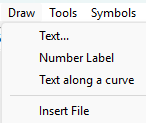
The easiest way is to create a new map in the style of your choice, create a new sheet called BITMAP or TRACE, and a new Layer called the same thing, make sure both of these are active and import the bitmap image into it using Draw, Insert File.
Follow the instructions in the command line to paste it correctly. You can either click for the corners or enter coordinates.
Becaues it's on it's own sheet you can move the image up or down the stack of sheets and give it transparency using a Transparency sheet effect on that sheet.
...
Alternatively, you could painstakingly convert the image into one suitable for use with TRACE or TRACED, but that takes time and patience in a bitmap editor as you would need to make it very high resolution all parts of it either opaque or clear and well defined. If as you say it's a relatively simple map it might be more a waste of time than simply importing it and hand tracing the components directly into your drawing.


-
Aerdyn Continental Map WIP
It looks really good :)
I was momentarily confused by the name Teufelsmeer until I realised that a meer was probably a sea (as the French is mer). If I had any suggestions it would be to make a more obvious difference between the land labels and the sea labels - perhaps make the sea labels a little paler blue?

-
Plans for an annual for next year?
Yes, there's always a new annual. Quoting from the Bonus Annual Issue – Random Hand-drawn Dungeons blog published today:
"Annual 2026 subscribers should have received their re-subscription offer for the Annual 2026. Please contact us, if you haven’t received your email."
That first date should be 2025. I've let Ralf know.
-
A first map, "The Mushrooms Lair (Thieves Hideout)"
That's a really good effort, Fishou.
If you were going to make any adjustments to it I recommend changing the background fill to something other than that rather scratchy stone background - not the cave floors but the surround. There are lots of others you can try in that style.

