


Loopysue
Loopysue
About
- Username
- Loopysue
- Joined
- Visits
- 10,415
- Last Active
- Roles
- Member, ProFantasy
- Points
- 10,161
- Birthday
- June 29, 1966
- Location
- Dorset, England, UK
- Real Name
- Sue Daniel (aka 'Mouse')
- Rank
- Cartographer
- Badges
- 27
Latest Images


-
how to feather the end of roads
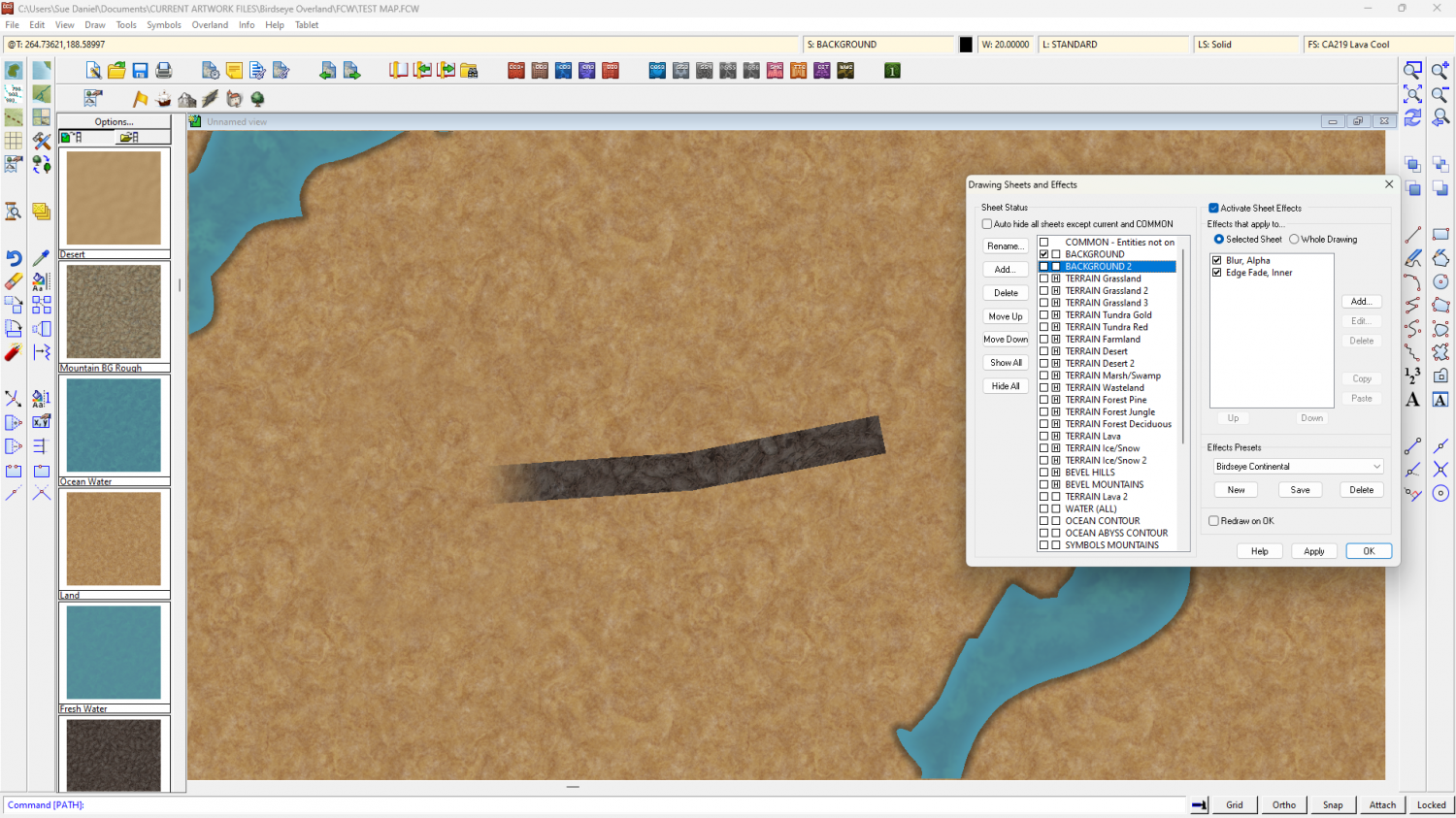
Add a new sheet above the roads (below them in the list order on the Sheets and Effects dialog), add a Blur, Alpha, and then an Edge Fade Inner sheet effect to it, and then draw a patch of the background texture on it over the end of the road. You will have to adjust the EFI until you get the desired fade length.
I use the Blur, Alpha to prevent Transparency Acne, which is an undesirable side effect when using the same fill on top of itself with an EFI.
Here I drew a 'road' of lava texture on my BACKGROUND land in an overland style, and then added BACKGROUND 2 with the necessary sheet effects to add the patch of more land texture over the end of the road.


-
Birdseye Continental - style development thread
Ok then. I'll leave it there for you two :)
-
Birdseye Continental - style development thread
Ok. Does anyone else still want the old volcanic texture, and call it "Volcanic 2"?
-
Birdseye Continental - style development thread
Thanks Don and Wyvern :)
I've taken a screen shot of that initial image showing the different types and stuck it in the file of reference material. That will be more useful for the regional version of the style. For me, this intial continental map style is more about the fact that this is a volcanic province and there are bumps on it - represented by the bevel ridges and the classic shield vocano cones.
I'm glad we've sorted things out a bit with the new terrain texture.

-
Birdseye Continental - style development thread
My experience of volcanoes is limited to recent Icelandic and Hawaiian erruptions - the last 4 years of them anyway, so the fill reflects at least the mood of what I've seen of the relatively flat ground around those eruptions, which seems to be surprisingly pale except where vehicles off road and turn the surface to reveal the darker colours, but I'll keep it for something else and try a volcanic-coloured version of the tundra fills.
Another reason for making it relatively pale is that the darker the fill is, the darker the symbols have to be, and the darker the symbols are, the less effective the map files are, to the point where you can hardly see any shading at all. Map files work best on mid-tone symbols like rooftops. We'll be ok with the regular mountains because they aren't as dark as volcanoes, but the volcanoes are certainly proving to be quite a challenge.

