


Loopysue
Loopysue
About
- Username
- Loopysue
- Joined
- Visits
- 10,419
- Last Active
- Roles
- Member, ProFantasy
- Points
- 10,163
- Birthday
- June 29, 1966
- Location
- Dorset, England, UK
- Real Name
- Sue Daniel (aka 'Mouse')
- Rank
- Cartographer
- Badges
- 27
Latest Images


-
What are the annuals?
The annuals are produced at the rate of 12-13 issues per year like a monthly magazine. You can buy any year, including the current one as a single annual, though you will get a new issue each month if you have the current year's annual until the year is over.
If you want to know what is in each one I made a wall of issue links right here: https://forum.profantasy.com/discussion/10366/cartographers-annual-all-the-issues-linked-in-one-place
Each link takes you to the little bit of Profantasy webpage that announces each new issue.
Most of the current bundle consists of grouped selections of annual issues from different years. There are lots of them in there - about a third of them.


-
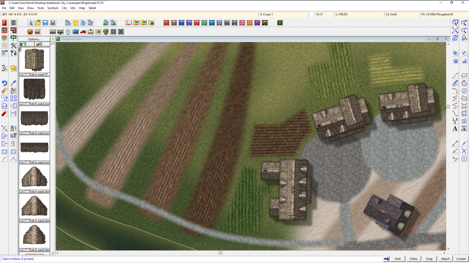
CA style development - "Darklands City" (issues for September and December 2021)
PART 2.
I've started working on the second part of this style by adding a few new terrain textures.
This is not a map just yet, but a place where I test new things to see how they work together. There was a request for more Earth textures...


![[Deleted User]](https://secure.gravatar.com/avatar/c75d9a245b74d9c59be0999ea81ca541/?default=https%3A%2F%2Fvanillicon.com%2F92add7f8c954488718110edc4896ad39_200.png&rating=g&size=200)


-
What's the Latest Thinking Around MacOS Install Options?
You're welcome :)
-
What's the Latest Thinking Around MacOS Install Options?
Hi Thomas - welcome to the forum :)
If you want to ask any of the people who took part in those other threads you've been looking at, it is ok to ask the question on that thread. You can also tag people who have said things that really interest you by using the 'at' sign, like this @ThomasHendrich
-
Another version of Jerion
I am so sorry! I seem to have made a mistake early on in our conversation by assuming you had acquired FT3 as part of the current Humble Bundle. A lot of what I said probably didn't make much sense to you at all.
So you purchased FT3 just recently, and that is what you have. You wanted to know how to get the same kind of results as I have here with Jerion. I am assuming you mean more than just the colouring in this version - that you mean the way it looks more generally.
I worked out a technique to create maps like Jerion in FT3, and the resulting tutorial was published a little while back as an issue in the 2019 Cartographer's Annual. That same issue, called "The One Day Worldbuilder" is bundled with The Worldbuilders Compendium in the Humble Bundle, and having made the mistake of assuming you were a Humble Bundle owner I was puzzled why you didn't have it.
Anyway! How to get it is the next question. You could just buy the Humble Bundle, which is cheaper than the Cartographer's Annual, and give away the bits you don't want, or you could wait for the Worldbuilders Compendium to become available separately to the Bundle in the near future. That second option is a gamble both ways, since I'm not entirely sure the One Day Worldbuilder will be part of that later publication, or if it will be more or less of a bargain than the bundle itself.
I am so sorry to have caused such confusion!

