


Loopysue
Loopysue
About
- Username
- Loopysue
- Joined
- Visits
- 10,417
- Last Active
- Roles
- Member, ProFantasy
- Points
- 10,163
- Birthday
- June 29, 1966
- Location
- Dorset, England, UK
- Real Name
- Sue Daniel (aka 'Mouse')
- Rank
- Cartographer
- Badges
- 27
Latest Images


-
Understanding Fog of War Effects
You're welcome :)
Night effects cover the entire area, so they reappear beyond the screen. However, when you save your map as a bitmap export (Save as... in the File menu) you will only be rendering the area of your drawing, so you won't see any of that.


-
Understanding Fog of War Effects
Have you followed the video or done your own thing?
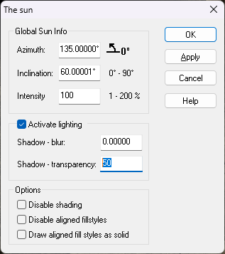
If you followed the video, when you added the Wall Shadow, Point Light Finalize sheet effect there was an option to pick an alternative colour for the shadow. In the video Ralf picks a dark blue shade instead of black. At around 9.19 minutes in that video Ralf then turns the shadow transparency up to 50 percent the The sun settings, which you can get to by right clicking the hourglass on the left and picking Global Sun.
Have you done it that way, or a different way?
-
Merry Christmas!


 and 1 other.
 -
Create maps with my own graphic elements?
If you don't need to do anything more complicated than what you just described in your last comment, Remy (Monsen) is right. There should be enough information in the User Manual.
The Tome would only be necessary if you wanted to make symbols that were considerably more complicated than that.
The User Manual gives you the basics. The Tome provides the masterclass.

-
Create maps with my own graphic elements?
Hello brandor :)
Yes, you can do all of that.
I recommend the Tome of Ultimate Mapping as a reference book that contains all the technical information you will need to do the job, and this forum as the place to ask for freindly and usually accurate help and advice.
