


Loopysue
Loopysue
About
- Username
- Loopysue
- Joined
- Visits
- 10,415
- Last Active
- Roles
- Member, ProFantasy
- Points
- 10,161
- Birthday
- June 29, 1966
- Location
- Dorset, England, UK
- Real Name
- Sue Daniel (aka 'Mouse')
- Rank
- Cartographer
- Badges
- 27
Latest Images


-
Ss6 not working
Just to make sure we are all talking about the same thing here, this is a screen shot illustration of the process Ralf described.
Click the new map button...
That brings up this dialog:
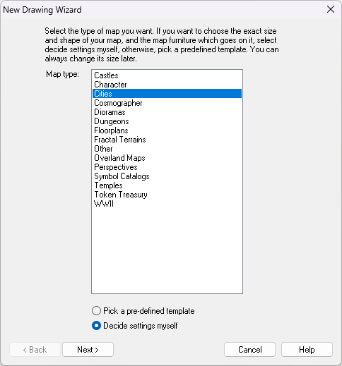
Then you select the Cities option and click Next, which brings up this dialog:
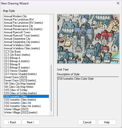
If SS6 is installed you should find the highlighted option near the bottom of the list - shown in the above screen shot.
Then you click Next again and go through the process of creating a new map in the SS6 style.
The question then is: which part of this isn't working?


-
March 2023 humble bundle
The bundle is an encore or repeat of the Maps Bonanza humble bundle from 2021.

-
can't view all of my map
Hi Helen :)
At this stage, where none of us know what extent or position everything should be in the map it might be easier to make a new HW map of the correct extent and then copy the details you want from the old map across to the new empty map. You can position everything as you paste it then. Be careful to only have the things you want to keep still visible as you copy. Hide things like the map border, screen and background before you copy from the old map.

-
resizing mapping area
Im thinking that I might have misunderstood the question. Are you drawing a fractal polygon using a drawing tool or the fractal polygon tool on the right? Or are you fractalising an existing line? Are the corners the nodes that stick out from the line?
-
Having trouble with settings
You have to click Apply to see the result.
And yes - most of the terrain sheets have the same issue.
The difference between those two settings is that the Percent of View Width is really huge at '10'. That's 10% of the width of your window. If you set 10 map units thats just 10 miles rather than possibly a few thousand miles.
