


Loopysue
Loopysue
About
- Username
- Loopysue
- Joined
- Visits
- 10,354
- Last Active
- Roles
- Member, ProFantasy
- Points
- 10,103
- Birthday
- June 29, 1966
- Location
- Dorset, England, UK
- Real Name
- Sue Daniel (aka 'Mouse')
- Rank
- Cartographer
- Badges
- 27
Latest Images


-
Realms Reimagined Rivers
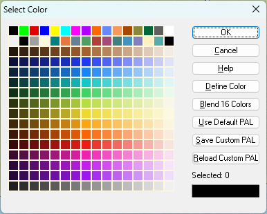
Good question. Because I've used custom palettes on quite a lot of styles, mostly to provide appropriate varicolour options or smooth out the jumps between the colours on the default palette, I've spent a whole lot more time looking at palettes than most people will have done, so I usually know as soon as I open the palette (though I clearly missed it in this case to start with).
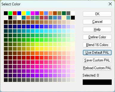
I suspect the best way of finding out is to click "Use Default PAL" while watching to see if the colours change in the grid.
This first one is a commonly used custom pal (mostly on my styles), while the second is what you see if you click that default button. Notice how the lime green and yellow colours jump out at you in the default pal.
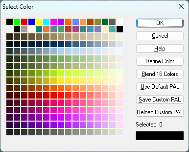
Other palettes can be very different, especially the one attached to Herwin Weilink (below) and styles based on it.
And the one I'm adjusting to give better varicolour hill colours for CC4 Overland in the last colour row.
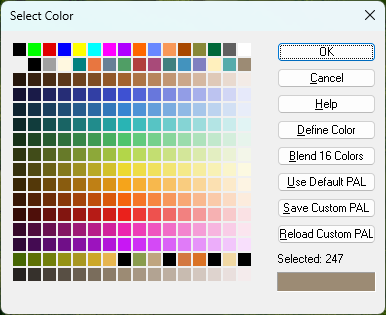
To change this last palette back to the default one would be disastrous for the varicolour hills.


-
Selling maps?
You seem to have some reasonably good maps in your galleries.
Have a really close look at other maps for sale in the same general category as yours. There are quite a few out there that aren't made by humans these days, but you can usually tell because AI doesn't recognise the difference between roads and rivers (just one of the more obvious examples). Once you've weeded out the AI stuff, look at the prices the human artists are setting for their work, the quality of the goods (size and resolution), and compare it with what you are offering.
The final price per copy is up to you to decide, and you might not gauge it right the first time. Better to be a little higher than too low, so you can drop the price if you don't sell anything. Once you've got it right, though, pricing the rest of your work after the first few will be a lot easier.

-
Rendering Artifacts
That's transparency acne.
Sometimes when the pixels in an overlying texture are the same colour as the pixels in the underlying texture, and there is a glow, edge fade, inner, or bevel of either type on the overlying texture's sheet, the rendering engine gets confused and fails to recognise there's anything there on the overlying sheet. So it's read as a pinhole exactly one pixel in dimension. That's why the holes are all the same size.
I have noticed that this is quite frequent with SS5, where all the fills have lots of little black marks, and are all quite similar greens and yellows.
You can try placing a new sheet with nothing on it between those two sheets which does sometimes work, or if it doesn't, copy the overlying polygons onto that new sheet along with the sheet effects. That can also sometimes work without further effort. If that doesn't work either, try changing the fills of the new copy polygons to Solid, and a colour that isn't in either texture. If you have to go that far you may need to increase the width of the edge fade to make sure it doesn't show through.
-
Numbers Don't Appear on Dungeon Map
Try clicking the Text Specs button next to it |CC2TSPEC|. There's probably a very tiny number in the Height box. Put something sensible like 10 in there and try again.

-
Looking for Black and White Cities Pack
Make sure you have checked the little box called "Send me the monthly newsletter email with any applicable offers" on your Profile tab, and check that your email address is correct. That way you may be able to get it at some point with an offer.

Black Friday is often also a good time to keep an eye on prices.

