


mike robel
mike robel
About
- Username
- mike robel
- Joined
- Visits
- 4,196
- Last Active
- Roles
- Member
- Points
- 435
- Rank
- Surveyor
- Badges
- 6
Latest Images


Reactions
-
1876 Centennial Campaign Map

-
1876 Centennial Campaign Map
This is a fairly simple map that shows the movements of the three US Army Columns and the Sioux Village movement from April 1876 - June 26. Obviously, I am only showing the rivers. I will be adding a legend and the north arrow.
There were three columns involved. The Gibbon/Montana Column (Light Blue) leaving from Montana and moving East. The Crook Column (Orange) moving North out of Wyoming, fighting a battle on 17 June, then giving up the field and going back to Wyoming until July. The Terry Column (Black), with Custer commanding the 7th Cavalry (Yellow) moving West from Dakota and Reno's reconnaissance with one 6 Companies of the 7th (Green).
Reno was about 50 miles from the Battle of the Rosebud (the lower 3 black dots) on the 17th, having discovered the Sioux Trail and then turning back due to lack of supplies. He disobeyed orders, but had he not done so, they would not have known where the Indians were.
Terry moved West along the Yellowstone with Gibbon's column aiming to move up at least as far as the Big Horn/Little Bighorn river junction while Custer was supposed to move North along the Little Bighorn, hoping to pin the Sioux between the two forces.
Custer then took the whole Regiment moved down the Rosebud until he picked up the Sioux trail, then disobeyed his orders to attack the Sioux village. Had he followed orders, he would most likely have come across the Rosebud battlefield, but they likely would have lost the Indians again.
The map is very busy. What I am going to do next is show where units are on specific dates so one can see the progress of the various groups on a day by day display so I can display the maps in PowerPoint to show the progress of campaign.
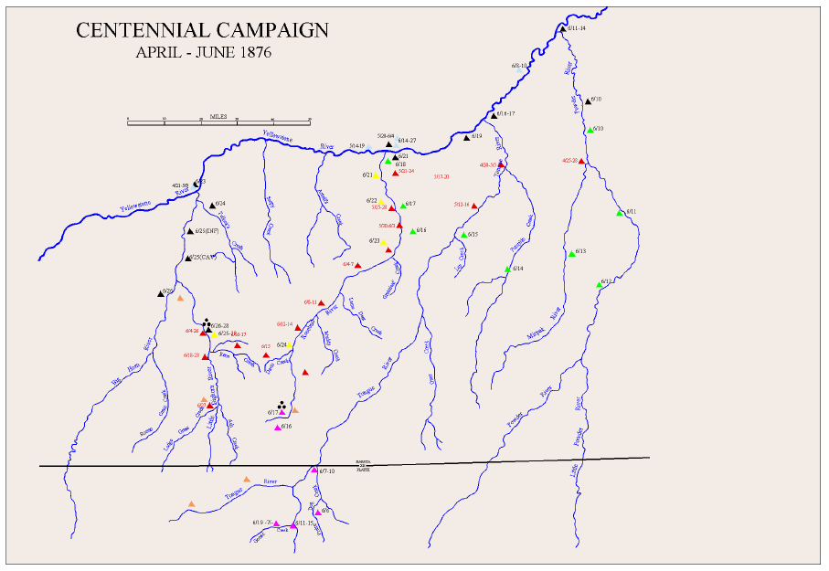
I am not likely to try and put any indications of terrain into the map because I think it will be too busy and I have been without success in trying to do maps with the hashmarks they used at the time to indicate hills..


-
Article showing meanders of Mississippi River over time
This is truly some awesome work. The original map is masterful and the LIDAR photos have a interesting quality.
-
What kind of music do you listen while mapping?
If I listen to anything, it is classical.
![[Deleted User]](https://secure.gravatar.com/avatar/c75d9a245b74d9c59be0999ea81ca541/?default=https%3A%2F%2Fvanillicon.com%2F92add7f8c954488718110edc4896ad39_200.png&rating=g&size=200)

-
Banners
Very Cool. Not that Spartan shields had anything to do with seals, but one allegedly had a life size fly painted on his shield at Thermopylae. They didn't use the Lambda then. When told that the fly was too small to scare anyone, he said, "It'll be big enough when I stick it in his face." Awesome work Sue.
