

1876 Centennial Campaign Map
 mike robel
🖼️ 15 images Surveyor
mike robel
🖼️ 15 images Surveyor
This is a fairly simple map that shows the movements of the three US Army Columns and the Sioux Village movement from April 1876 - June 26. Obviously, I am only showing the rivers. I will be adding a legend and the north arrow.
There were three columns involved. The Gibbon/Montana Column (Light Blue) leaving from Montana and moving East. The Crook Column (Orange) moving North out of Wyoming, fighting a battle on 17 June, then giving up the field and going back to Wyoming until July. The Terry Column (Black), with Custer commanding the 7th Cavalry (Yellow) moving West from Dakota and Reno's reconnaissance with one 6 Companies of the 7th (Green).
Reno was about 50 miles from the Battle of the Rosebud (the lower 3 black dots) on the 17th, having discovered the Sioux Trail and then turning back due to lack of supplies. He disobeyed orders, but had he not done so, they would not have known where the Indians were.
Terry moved West along the Yellowstone with Gibbon's column aiming to move up at least as far as the Big Horn/Little Bighorn river junction while Custer was supposed to move North along the Little Bighorn, hoping to pin the Sioux between the two forces.
Custer then took the whole Regiment moved down the Rosebud until he picked up the Sioux trail, then disobeyed his orders to attack the Sioux village. Had he followed orders, he would most likely have come across the Rosebud battlefield, but they likely would have lost the Indians again.
The map is very busy. What I am going to do next is show where units are on specific dates so one can see the progress of the various groups on a day by day display so I can display the maps in PowerPoint to show the progress of campaign.
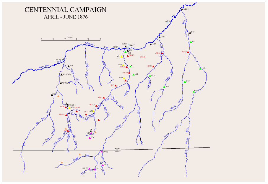
I am not likely to try and put any indications of terrain into the map because I think it will be too busy and I have been without success in trying to do maps with the hashmarks they used at the time to indicate hills..


Comments
It looks good :)
Hachures are something that can't be drawn automatically in any app. Well, not true hachures anyway. Most hachures are not done properly when they appear, but are only used as rough indicators of slope.
When I was at college many years ago, one of the 'units' I did as my course was The History of Cartography. It was pretty dry and surprisingly uninteresting for the most part because we didn't look at any actual history or even individual cartographers and maps. I didn't even know about the Ferraris Map until quite recently. Instead it was all technical 'how this was done', 'how that was done'. Hachures I remember well. Their length, width and density all depend on length and steepness of slope. I'm not even sure I could do a hachured map, even though I know the precise theory and have the ability to draw. It is a seriously skilled piece of work to do a single slope, never mind a whole landscape. Hat's off to those Swiss cartographers who made them so famous!
So don't feel bad about not doing hachures. Never feel bad about that. Doing hachures the right way is like painting the Mona Lisa. Dead difficult, and there are a thousand easier ways of doing it that look just as attractive in their own way.
Thanks Sue. Sometimes I think simple is better. Adding contours would only confuse things and I think obscure the details I am trying to show. And this map isn't to use for a war game any way. I'm better at reading maps than making them, although mentally I can visualize the way the ridges would look, I can't figure out how to draw it in a manner that conveys the terrain's compartmentalization in anyway but using contour lines. I really respect the ways officer's were taught to draw back then.
On the other hand, large parts of the planning map they used were featureless and filled with guesses as to river locations and how they ran. I'm not sure the troop commanders even had maps, although there is a picture of Custer and some of his scouts looking at one in a different campaign. They didn't really know where the little big horn was, they just had to accept what their Indian Scouts told them.
Hachures. I now have to learn how to hachure. Someone on the internet said they were unnecessarily complicated and of limited utility. And I must now commit to it.
Thanks alot @Loopysue
Great map @mike robel
@Lillhans Thanks!
You might be able to get away with contours that are colored only a shade or two off of the background. If you really want a fun result, something like Tanaka contours (contour lines that are a shade lighter on the lighted side and a shade darker on the unshaded side - see http://wiki.gis.com/wiki/index.php/Tanaka_contours ) can look really good. They are a lot more work than regular contours, though, and probably need support from a generating program unless your patience approaches unlimited.
As far as hachures go, they are pretty much contours, but the lines are drawn perpendicular to the contour line itself in the direction of steepest descent with density and thickness coding ( http://wiki.gis.com/wiki/index.php/Hachure_map ). Again, not something that you would normally want to do by hand, but something that a suitable piece of software can do. Hachures are an example of something that is done with a simple pen rather than more complex tools. Using different shades for the individual hatchings can bring additional levels of information to the map, but a basic hachure map is complex enough as is!
A simplified form of hachure that's often seen is basic little hatches around a line at constant altitude and/or slope without worrying about length or thickness aspects of the hachures. There may be multiple levels of these hatches around the perimeter of an area. The ESC tool in CC3+ is particularly good at this: draw a rough contour at the level you want, use ESC to draw things along that contour, and finally hide or delete your original contour to get the "caterpillar mountain" effect.
It might have been better if I tried the Napoleonic style instead of my standard political style...
I don't know. What you've done has the advantage of real clarity, and to an extent, it reinforces the "area of the unknown" the events took place in, given the river valleys were the only places relatively rapid travel was possible.
This is the NPS map. It gives you a little bit of terrain appreciation.
This is a period map finished that is similar to what they would have used to plan on.
and this is a close up of the battle area, note there is very little detail in the battle area.