


Wyvern
Wyvern
About
- Username
- Wyvern
- Joined
- Visits
- 3,266
- Last Active
- Roles
- Member
- Points
- 5,584
- Rank
- Cartographer
- Badges
- 24
Latest Images


-
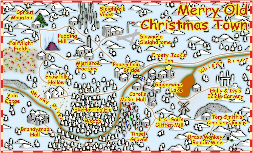
Festive Winter Card Challenge - Ended - Please vote for your favorite
This is my somewhat unexpected entry for this contest; unexpected as when it was announced I was, and indeed remain, deeply involved with the next part of my Nibirum mapping project for the Community Atlas. As explained elsewhere on the Forum though, once you start having ideas it's difficult to escape their implications...
So, here we have Merry Old Christmas Town, sort-of British-style:

I've added a higher-res version to my Gallery as well, albeit this one's not come out too badly at the usual Forum maximum size, as the style seems to cope quite well with increased anti-aliasing without becoming too large.
Just to clarify, this was prepared using ONLY CC3+; there's been no post-processing of any kind.
Feels slightly weird not to be submitting the map for the Community Atlas as well for once!


![[Deleted User]](https://secure.gravatar.com/avatar/c75d9a245b74d9c59be0999ea81ca541/?default=https%3A%2F%2Fvanillicon.com%2F92add7f8c954488718110edc4896ad39_200.png&rating=g&size=200)


 and 4 others.
 -
Festive Winter Card Challenge - Christmas Town
When @Monsen announced the latest Forum mapping contest, for a (winter?) holiday-themed postcard-sized map, I was deep in the latest part of my Community Atlas mapping project for Nibirum, and indeed still am, so wasn't sure if I'd have time to do something useful for this as well. But you know how it is when you start having vague ideas for something...
Thus away from any CC3+ mapping, I jotted down a few silly place-name thoughts. Since some early comments on the contest topic had suggested something holiday-themed appropriate to the place of origin would be suitable, I focused into aspects of the Christmas period in Britain, which of course include ghastly jokes, puns and other nonsensical daftness. I'm not sure how far all these may survive beyond these shores; however, it's too late now, as the map's done!
My original list of nearly 40 place-names was quickly halved, given how small a postcard-sized map would be, and then being me, I sketched-out by-hand on squared paper where all these places were going to be in a rough sense, based on random dice rolls. The square sizes were chosen based on an estimate of the size the symbols would be on such a small map, to hopefully avoid over-crowding.
I'd already decided I wanted to use the standard CC3+ Overland Vector Color style for the map, as I have a fondness for vector styles, and this overland style in particular. Vector symbols have the advantage it's often quite possible to add-to, amend or adjust existing symbols, or even create new ones, without them looking too awful, given my legendary lack of artistic ability...
When I began, I had the loose notion I might try and take a few screenshots for a WIP topic here, though I soon forgot all about that unfortunately, as the map started to come together remarkably quickly, after a few early tweaks to get the symbol sizing to look right. I created a few fresh tools, and tinkered with the Effects in places, though nothing very major or time-consuming. The latter needed adjusting mostly because the Effects had been set for a much larger mapping area, of course, while the former needed adding because for some unaccountable reason, the style's designer hadn't prepared for drawing whisky rivers and snowy roads in advance. Some people are strange 😉
Handily though, the style's symbols all have really helpful varicolor options for being snowy-frosty white in just the right places (with a couple of minor exceptions, where a few snowy flatter roofs had to be added by-hand). In barely a couple of hours, the basic map was done. It needed a few fine-tuning adjustments, but the longest task, once all the labels were added, was trying to work out the better colour combinations for those labels and their Glow Effect, so they'd stand-out nicely, without being overwhelming. That dragged on for over an hour, to the point where I'm sure I ended up more or less where I'd started!
And so we have Merry Old Christmas Town, British-ish style:


-
[WIP] Modern city map
You'll be showing us the railway timetables to get to Oakwood next (but I'm not getting on Joe Sargent's bus there)!
[The latter's a Lovecraft reference from The Shadow Over Innsmouth story for anyone confused...]
-
Community Atlas: Errynor - Aunty MacKassa's Home & Vehicles
-
Community Atlas: Errynor - Aunty MacKassa's Home & Vehicles
The second of Aunty's vehicles, and the concluding drawing in this whole Errynor Map 01 set, is Scuttle, as promised earlier, a giant-crab-legged, ramshackle, shipwreck hut. This has two floors, accessed by toggling in the Atlas' FCW map, with a further toggle option to add a five-foot grid:
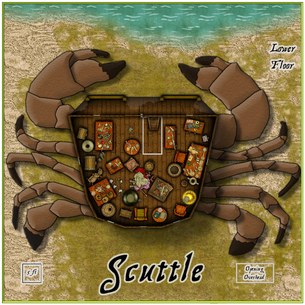
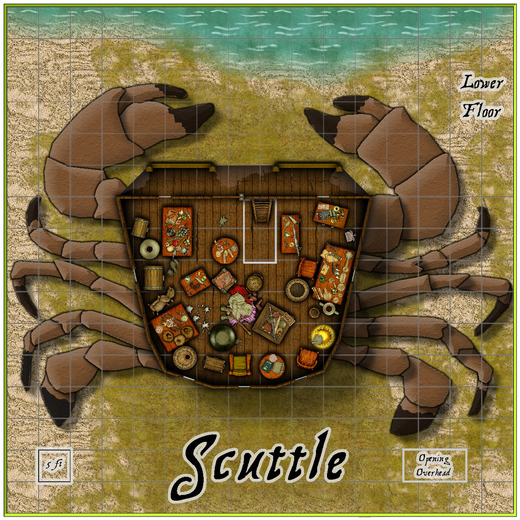
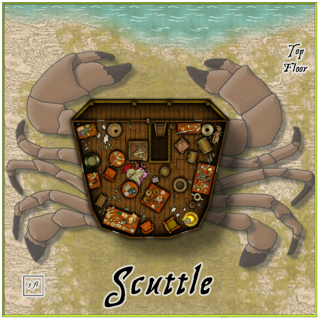
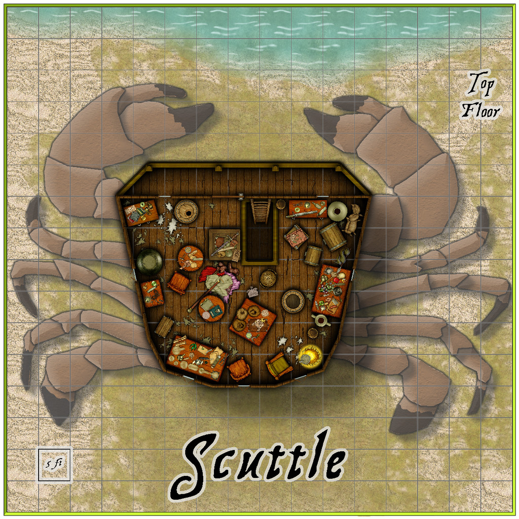
For the crab legs, I tried sourcing top-down crab images online, but couldn't find one that worked well enough for what I wanted for tracing. There are few crab symbols in CC3+ and its add-ons, and although I did find one that looked good among the free Dundjinni Archives collection, it wouldn't scale-up properly without becoming too pixelated. In the end, I used that enlarged symbol as the base, and partly traced, partly redrew, the legs as individual segments on different Sheets, and then fitted them to the base of the hut, as now illustrated.
The bulk of the hut and its contents were copied from The Naughty Lass deck plans, the walls and windows redrawn, and a driftwood balcony added to the front of both lower and upper floors, partly to increase its overall crab-like appearance. By contrast to the ship, these drawings largely flew together quickly. A fresh PDF and text file of notes and - done!
Hopefully, more Errynor maps to follow!


