

Community Atlas: Errynor - Ellenge Town
 Wyvern
🖼️ 293 images Cartographer
Wyvern
🖼️ 293 images Cartographer
As the ideas for undersea Kachayan settlements I'd been developing while working on the Shark Bridge maps were still fresh in mind, I decided to continue in that vein for the next Atlas map. In my original planning for the detailed maps from Errynor Map 01, I'd pencilled-in the largest Kachayan settlement, the city of Kelchayn in the northwest corner for further action. However, the way the Shark Bridge settlements had progressed turned my thoughts instead towards their Province's capital, Ellenge.
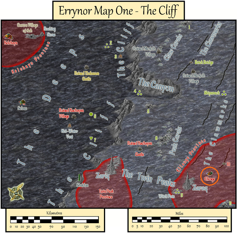
Having established earlier that Ellenge and Twin Peak Provinces had once been parts of the single, larger Kachayan Province of Twin Peaks, and that Ellenge had once been a city, now fallen on harder times, ideas began forming of a core of still-inhabited structures surrounded by disused to collapsed properties further from the centre. Then thoughts coalesced further, to the point of a major disaster or accident having destroyed part of the old city.
Revised semi-random systems from decades ago let me roll-up numbers of inhabitants for both the old city and still-extant town, which in turn allowed the number of structures involved to be determined. Additional random-table-creation and fresh dice-rolling devised lists of shops/businesses and community assets to be included. The appearance of a magical academy in the old city ruins from these provided a plausible candidate for the cause of the accident, an idea which was developed further before proceeding.
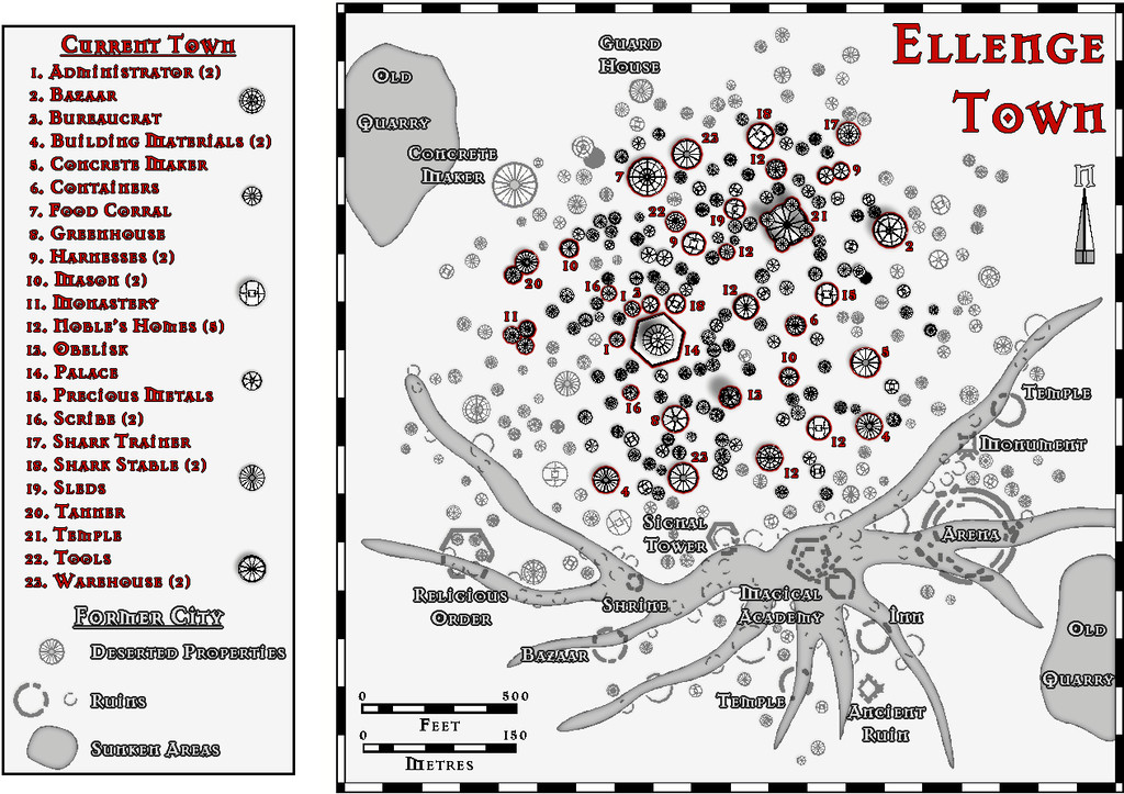
Since Kachayan sea-bed architecture concentrates heavily on domes, and wishing to continue the practice of using black-and-white mapping styles for these lightless deep sea settlements, I opted for the Cartographer's Annual package from April 2010, Black and White City Maps for this map, as it has a convenient selection of circular building symbols, originally meant as huts and tents, that would work just as well for domes. I knew already I was going to create the layout randomly using the Symbols In Area mechanism (no streets on the sea-bed!), so I drew a circle of appropriate size for the old city on my base map template, and populated it with the requisite number of domes/huts. I'd deliberately allowed some potential overlap of the symbols to let me identify where the larger final structures might be placed too.
Knowing in advance (for reasons I shan't disclose here!) that the worst-affected ruined area was to be towards the south and southeastern sides of the settlement, let me select a suitable number of domes for the surviving inhabited town away from this area. After that, it was simply a matter of going through the random map and deciding what building needed to go where from my pre-generated list. This also entailed changing some symbol sizes, and occasionally adjusting the shape by replacing those initially laid down with different symbols. Some symbols were also moved from their original placements, such as moving apart those "ordinary" domes that were still overlapping one another, and shifting others to help lose the "circular edge" effect because of the opening construction process.
Then it was time to show the area most affected by the magical accident across the southern city. I wanted this to look a bit unusual, not with a simple "radiating blast" form, but something odder and more organic - magical power flowing forcibly, rather than shooting, while also hinting at possible altered effects because of the deep-sea pressure. So I drew out a batch of spidery construction lines from the Magical Academy, and adjusted them a little, before replacing them with a spread of depressed channels, a polygon drawn using the style's normal river drawing tool.
The deserted/abandoned structures were easily demonstrated by moving them to their own Sheet, and applying a Transparency Effect to it, so those places still in use took on a sharper look by contrast, with darker lines and more marked shadows. The ruins proved more difficult. At first, I tried partially drawing over the normal dome symbols using aptly-shaded polygons, softened by Sheet Effects, to try to make them look as if they were partly silted-over. This didn't really work as I wanted, however, so I opted instead to replace each ruined structure with a broken outer wall line or lines, sometimes with "rubble" as well. Most of these ruins were merely circular rings fragmented using the Break command, with some pieces shifted away from their original spots slightly. Others were drawn polygons of appropriate form, tracing some of the lines of their original symbols, again using the Break tool to create holes in the walls, and fresh "rubble" to be moved from their preliminary spots. Having made the decision, this proceeded quite quickly.
Another problem cropped-up when I was trying to add a highlighting red Glow Effect around the edge of those still-occupied symbols that had an identified function. Other Effects already on the various SYMBOLS, DOMES Sheets interfered with this, and meant it wouldn't work correctly. An attempt by copying the affected symbols onto a new Sheet beneath their original, and applying the red Glow Effect only to that worked for the outlining nicely, but caused problems for the Blur and Shadow Effects on some, though oddly not all, of the Domes Sheets! This was finally resolved by drawing simple polygons or circles of identical shape and size to replace the symbols copied onto that lower "Glow" Sheet. I'm sure those more technically adept with CC3+ could have come up with a simpler, more elegant solution to this, though at least it worked for me!
After all this, adding the labels, scales, title and key for the still-occupied properties proceeded apace, using the CC3+ standard Mason Serif Alt Bold font. A pair of sunken-area old quarries for the city's building stone were added as well, and the surface map was complete:
Surface map? Well, yes. The magical "accident" fifty years ago or so that devastated the southern old city, including several major places there, seemed an ideal opportunity to create a somewhat paranoid ruling political structure for the current town. So while I'd always intended part of the city's buildings to be below the sea-bed, this became a more substantial undertaking, with a series of secret tunnels and subterranean places deep beneath the settlement. These can be seen in relation to the surface features by activating the SUBTERRANEAN Layer in the map:
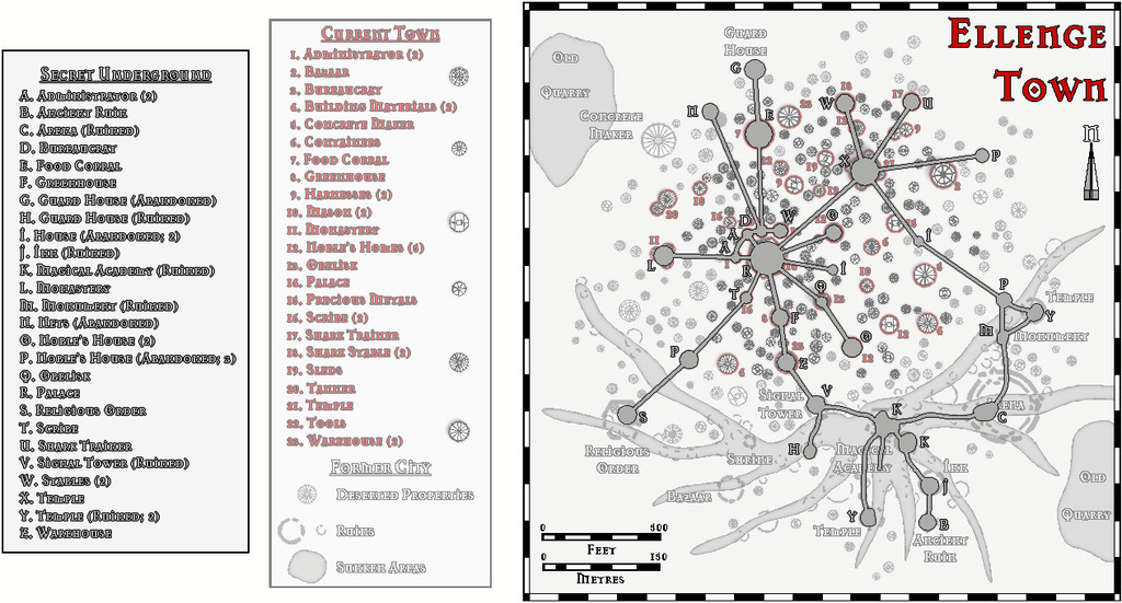
By turning on the TUNNELS BACKGROUND (S) Sheet, the surface map is hidden, so just the underground system can be more clearly viewed:
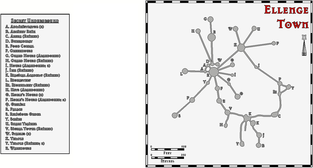
The idea is both aspects can be accessed by toggles in the Atlas version of the FCW file.
Most properties at Ellenge, whether linked to the Secret Underground or not, also project some way below the sea-bed, typically no more than four or five "storeys", though in a fashion more like cellars on land. These are not illustrated on the map, however, much as they rarely are for ordinary surface city maps.
As usual, a PDF and text-file of notes accompanies the map, with additional descriptions and details on the city/town's general background, and for the labelled properties, with a list of those shops and other sites determined for, albeit no longer identifiable as such within, the deserted and ruined areas of the settlement.
![[Deleted User]](https://secure.gravatar.com/avatar/c75d9a245b74d9c59be0999ea81ca541/?default=https%3A%2F%2Fvanillicon.com%2F92add7f8c954488718110edc4896ad39_200.png&rating=g&size=200)


Comments
Now in the atlas. Thanks for the contribution Wyvern.
This is also the 600th map in the atlas. Congratulations.
Thanks @Monsen! We seem to have amassed a lot of maps recently, given we were just at 500 back in early March! Much of that's down to the efforts of JimP and Quenten, plus other contributors, of course, so it's really congratulations all-round!