


Wyvern
Wyvern
About
- Username
- Wyvern
- Joined
- Visits
- 3,266
- Last Active
- Roles
- Member
- Points
- 5,585
- Rank
- Cartographer
- Badges
- 24
Latest Images


-
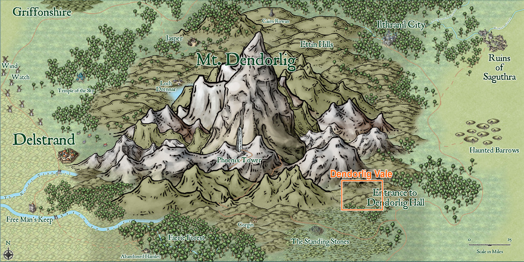
Community Atlas: Dendorlig Vale, Malajuri
If you read through the draft PDF version of my notes on Dendorlig Hall Village, part of the megadungeon/abandoned Gnome city I've been working on this year, which was added to this Forum topic on 18th Feb, you might have spotted I mentioned there a couple of places outside the Hall complex, above ground, including Dendorlig Vale. At the time, I wasn't sure if I'd be mapping that area as well, having already distracted myself far more than I'd intended away from my main focus of mapping the Errynor region in NW Alarius.
This impression wasn't helped by a couple of abortive attempts to design the map during February-March, as although I'd a hand-drawn set of ideas for the area's layout, when it came to the CC3+ mapping, I couldn't get it to look like how I wanted, in the styles I'd thought might work best. There were two main reasons for this. One was that neither of my preferred styles had a complete set of options for the structural features I wanted to add. The other was that the colour palettes involved were rather too close to the Alyssa Faden style, which I'd already used in my earlier Clack Valley map for the Atlas, and I couldn't get past the fact it felt too much like mapping the same place again; daft, of course, as it isn't, but that's what kept tripping me up.
Thus matters rested, and I'd half-decided I probably wouldn't map the Vale area after all, until I saw the brand-new E Prybylski Watercolour style in the just-released CA 196, and realised it would work very nicely for what I wanted! So here it is, still subject to amendments, given the Hall's own mapping remains in-progress only, but I am happy with the overall look now:
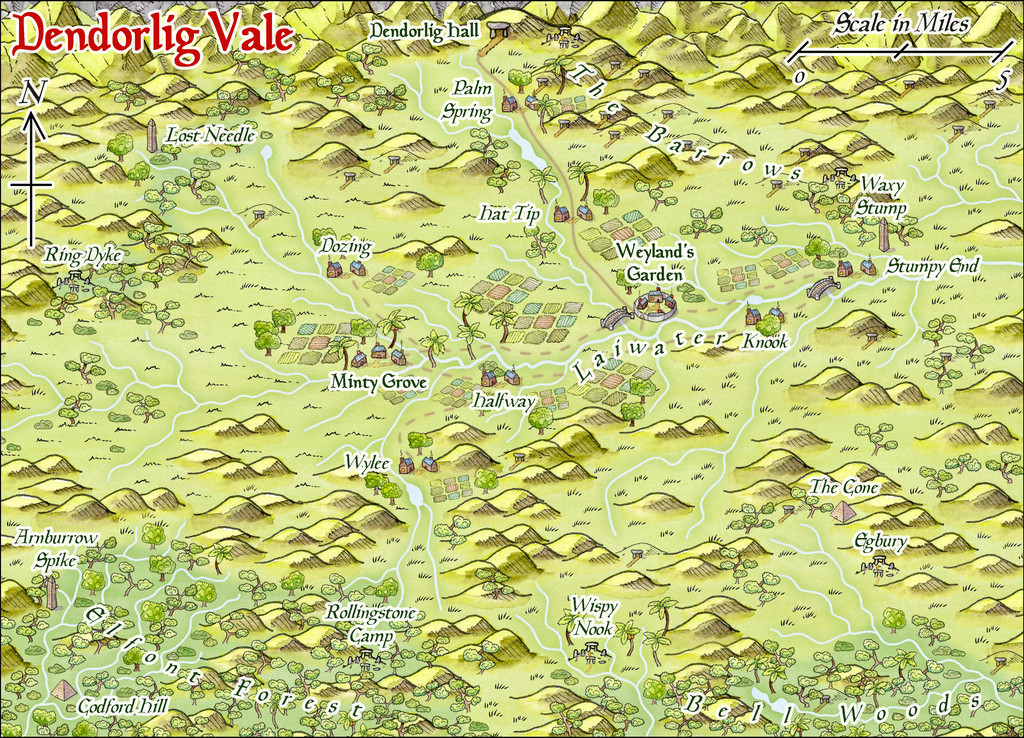
It's a very attractive style to my eye, and fits nicely with the somewhat bucolic view I had of the repopulated agricultural lands south of the Hall, peopled by Gnomes and Halflings, hence the names. There's a higher-res version in my Gallery as well, although even at the reduced-size for the Forum, the style seems clear enough already.
Now though, I've got another map to do a write-up for, besides Dendorlig Hall!
So this won't be going into the Atlas immediately, but, and with apologies for the belatedness of the request, @Monsen, could you reserve the Dendorlig Vale area on the Mt Dendorlig Region map in the Atlas for me, please...


-
Community Atlas: Dendorlig Hall - A Sort-Of D23 Dungeon for Nibirum
GM's Day today seemed an apt moment for another progress update for this project, which is continuing, if having been somewhat interrupted at times by external events since my previous post. In the interim, the handwritten notes for the place have reached area 168 now!
However, today's notes focus on the re-explored parts of Dendorlig Hall, which, as mentioned earlier, comprise areas 50-66, 93-110 and 143-146. These have been allocated the same red numbering colour as the reoccupied "Village" section (areas 1-49), as also discussed before, while the unexplored bulk of the underground complex has been numbered in black. This illustration shows the south corner of the map, covering all the "red" areas now, as well as the nearby "black" ones (and remember, south is now towards the top right corner of this map as viewed here, north towards the bottom left; the Water Temple area, 17, in the top right corner, handily provides a reminder of the cardinal directions with its arrowhead-shaped sub-chambers).
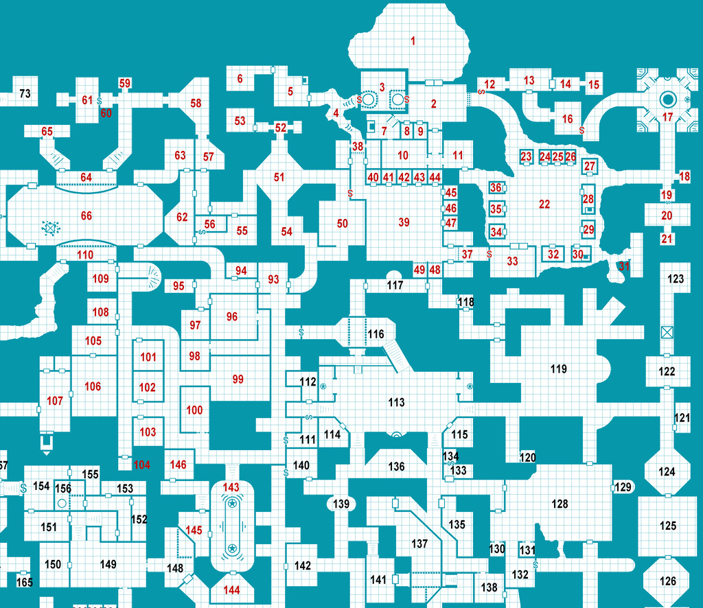
Note that only the red numbers have been adjusted to better fit their locations on this image so far. I've been amending the number-placements beyond this only as I've been typing-up the notes, as well as making occasional amendments to the room layouts, and that type-up still lags considerably behind the hand-scrawled descriptions, by about 70 areas currently.
Next here are the extracted notes as a PDF for just the re-explored zone. In the final full PDF and text notes, it's intended they'll follow along directly after the "Village" notes that I posted here last time, and will then continue into the unexplored parts as well (so you may need to re-read parts of last time's PDF to get these new notes to make sense; or what sense they may make at this stage, anyway...):
As before, these are just the draft notes, and haven't been fully checked as yet, so may be subject to changes later, but they will give some ideas as to what's been happening.
From the original map alone, it's long been clear that some areas of variable shapes, sizes and connections, have mutual links or locations that suggest a main purpose or function - that's what prompted the whole reoccupied "Village" concept initially, for example. From that base, it's followed naturally that the Hall area, far from being a random dungeon (even if that's how it began!), was really an underground town or city-sized settlement originally, and one which had been expanded and adapted at different times. Hence we have places such as the Arena (66, whose ancillary rooms extend into the unexplored zone as well) and the Stone Garden (143) from the latest PDF notes. Elsewhere, there is already a former nightclub-like entertainment venue, with a separate dance-hall/plaza, a communal swimming pool, a royal palace, and the royal tombs, with other features noted for possible inclusion that are still to be emplaced subsequently. Some of these have been inspired by the random Wizardawn room descriptions; sometimes those descriptions have dovetailed beautifully into what I'd decided the areas were to be, without first checking the notes (which always raises a smile), although much remains to be finally defined.
More when I know what it is!


-
Community Atlas: Dendorlig Hall - A Sort-Of D23 Dungeon for Nibirum
Today's update is partly a minor way to revisit the original premise behind the whole D23 concept, creating a dungeon room a day through the year. While it was never my intention to aim at trying that, because of the way I've developed the Dendorlig Hall map and description so far, as mentioned, areas 1 to 49 are effectively separate to the rest of the map, as being the reoccupied "Village" area closer to the cavern entrance. As today is day 49 of 2023, an update on how these first 49 places have developed seemed apt. The image below shows the current state of this part of the Hall complex:
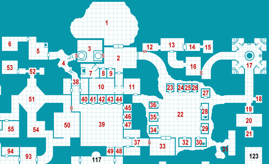
There've been a few changes since the previous update, including increasing the label text sizes (and having to move one here off the actual labelled area itself), along with setting up a different label colouring for those parts of the Hall that have yet to be reinvestigated by the incoming Gnomes. Note that those black labels have not yet been repositioned after their sizes were amended.
And to complete the process to this point, here's the PDF covering just those first 49 areas for those interested. Be aware though that this is a draft version of the typed notes only at this stage, so may yet - like the map - be subject to further changes. It does though give a comprehensive view of how my thinking has progressed regarding amending the random notes from the Wizardawn system, in combination with how I felt this part of the dungeon would operate.
Where we go from here is a little less straightforward, or rather when might be appropriate to post about it here, following the same "timing" theme as today, since the explored areas outside this Village section don't comprise a simple straight run of numbered places (as noted before, these are areas 50-66, 93-110 and 143-146). In the final PDF and text notes for the Atlas, these will be collected together for detailing ahead of the rest of the unexplored complex, a process which has already begun, in fact, as getting the notes typed-up has so far progressed to area 104 of these three segments, while my handwritten notes cover through to area 140 right now. Only another 220 areas to go!
It has been fascinating, as it often is, to adapt the random information from Wizardawn into something that works better here, though I still feel I've been adding a few too many of the coin treasures at times (the classic D&D treasure type going right back to the original system, for those less familiar). Of course, those using the Atlas are naturally free to ignore or amend whatever they wish from these notes, so I've not been too concerned at this. It has been entertaining though to sometimes find the random system has come up with something perfectly suited to a given area, along with occasionally needing to resolve the equivalent to the old joke of finding "40 kobolds in a broom closet". That's what being inspired by random design systems will do for you, though!
-
Commercial use of maps
Yep, I think many of us have learnt far more than we wanted to about the murkiness of copyright and IP laws in different parts of the world in recent months, thanks to events elsewhere in the RPG world.
Bottom line is it's probably safer to create your own new maps from scratch, than try copying anything someone else has done, however varied, especially when you're intending to make money from doing so.

-
City locations
Might want to tweak the angle of the seating a little for the rows nearest the outer walls; otherwise, patron complaints about stiff necks can be expected!
Will there be upper levels too?

