


Wyvern
Wyvern
About
- Username
- Wyvern
- Joined
- Visits
- 3,266
- Last Active
- Roles
- Member
- Points
- 5,585
- Rank
- Cartographer
- Badges
- 24
Latest Images


-
Community Atlas: The TlokPik Area of Nga-Whenuatoto
All of which brings us to the subterranean version of the "Crypts" dice set design that started this journey on Mate Ora:
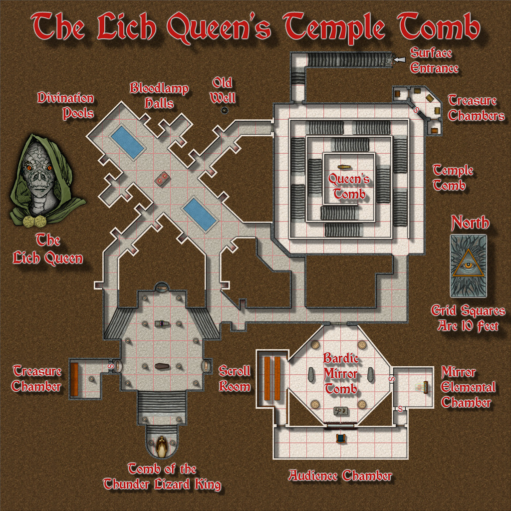
This was constructed using a range of assets from Dungeon Designer 3, Sue's two Creepy Crypts Annual issues, CA 186 and CA 188 and Character Artist 3. The latter wasn't merely for the portrait of the Lich Queen, as the harp and lute on the altar in the Bardic Mirror Tomb (if you can spot them!) also derived from there (though I had to use the vector lute, as the newer bitmap drawing style of CA3 doesn't have one). This time, while some features originated from the group of random tables mentioned in my first post here, many of the more detailed elements derived, sometimes in modified forms, from the Inkwell Ideas "Dungeonmorph Delves and Descriptions" book for the Crypts dice designs being used in this case. One of the larger changes was to swap the Tomb of the Wyvern King for the Tomb of the Thunder Lizard King; obviously, a heart-rending decision 😉, but an essential one, given I've already provided more than enough details on Wyvern Lords and their riders, for Kentoria elsewhere in the Atlas! Plus the Thunder Lizard concept fitted better for Mate Ora, due to the large numbers of prehistoric creatures, including all manner of dinosaurs - some of them undead - that roam the island. More information will be found in the PDF and text files that go with this map.
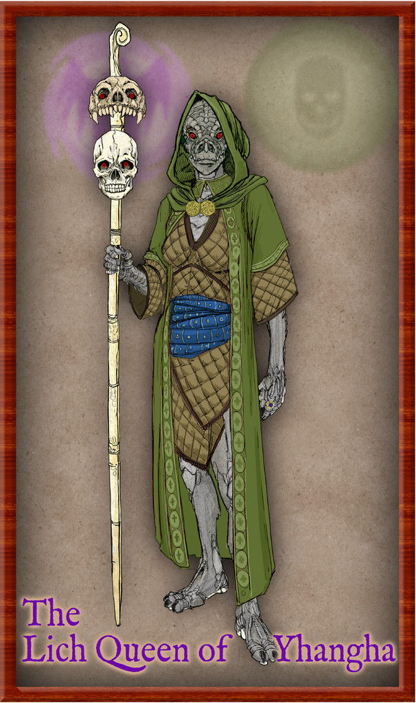
Naturally, that Lich Queen's portrait didn't just draw itself here, as it's extracted from a fourth Atlas contribution from this set, a complete illustration of the lady in question:
Next time, in the fourth and final instalment of the Crypts dice maps, I seem to be heading off to Alarius, in the region of the southern Scar there, according to the dice roll!


-
Community Atlas: The TlokPik Area of Nga-Whenuatoto
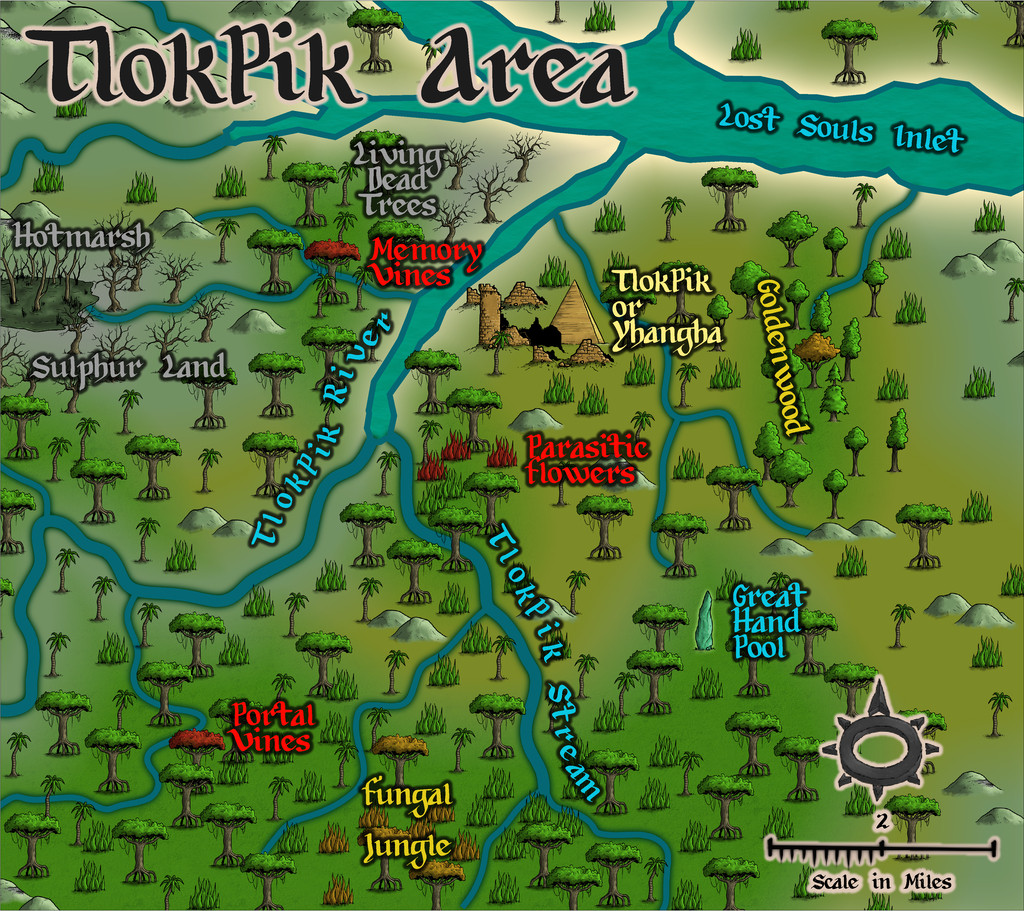
While the next map in the zooming-in sequence is for the Village, it was actually prepared only after the subterranean tombs one, because various overground features had to be fitted to that map design. While the Village map did draw on the Inkwell Dice "Ruins" design too, because that provided simply a base street layout around the pyramidal ziggurat structure, surrounded otherwise only by debris and a few ruined wall-lines, I elaborated on that somewhat, as while I wanted to use that layout as the Village's centre, I also wanted to show the above-ground area within which the lich, now the Lich Queen of Yhangha, was trapped. Random rolls on the suite of tables noted earlier provided further points of interest, and a selection of creatures and things a group of adventurers might encounter in this area if they visited it (which list is in the map's accompanying PDF and text files), some living, some undead. The map:
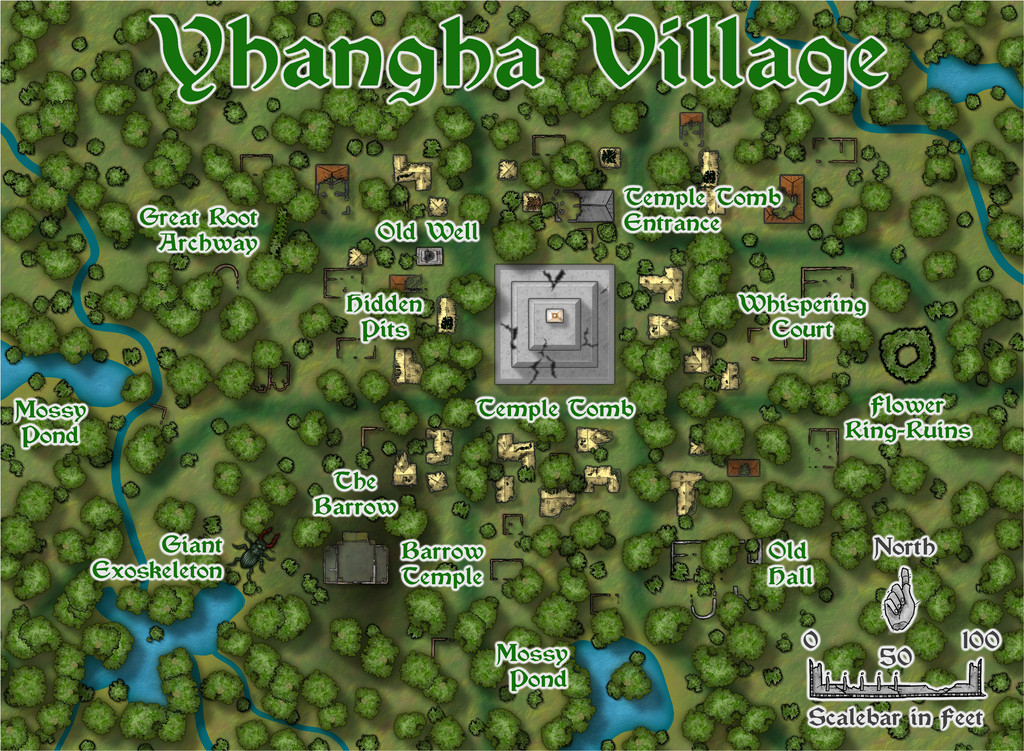
The fact there's both a ziggurat and a barrow mound here is partly why the translation for "TlokPik" referred to "hill(s)" in plural, of course.
I chose the City Designer 3 Bitmap B style for this map, primarily because it allows the City Ruins Annual to be used fairly seamlessly with it, which provided the distinction between different kinds of partly-roofed ruins I wanted to help loosely define the area the Lich Queen cannot leave (it's the region with the yellow straw-roofed structures around the Temple Tomb ziggurat). That loose definition is quite deliberate. Oh, and one other feature of this inner zone, that I termed "The Glade" in the descriptive notes, is that the night sky seen from it isn't that of Nibirum, but somewhere else entirely. Should it ever change back to Nibirum's, the spell will be broken and the Lich Queen will be able to leave the area. Just waiting for the stars to be right...
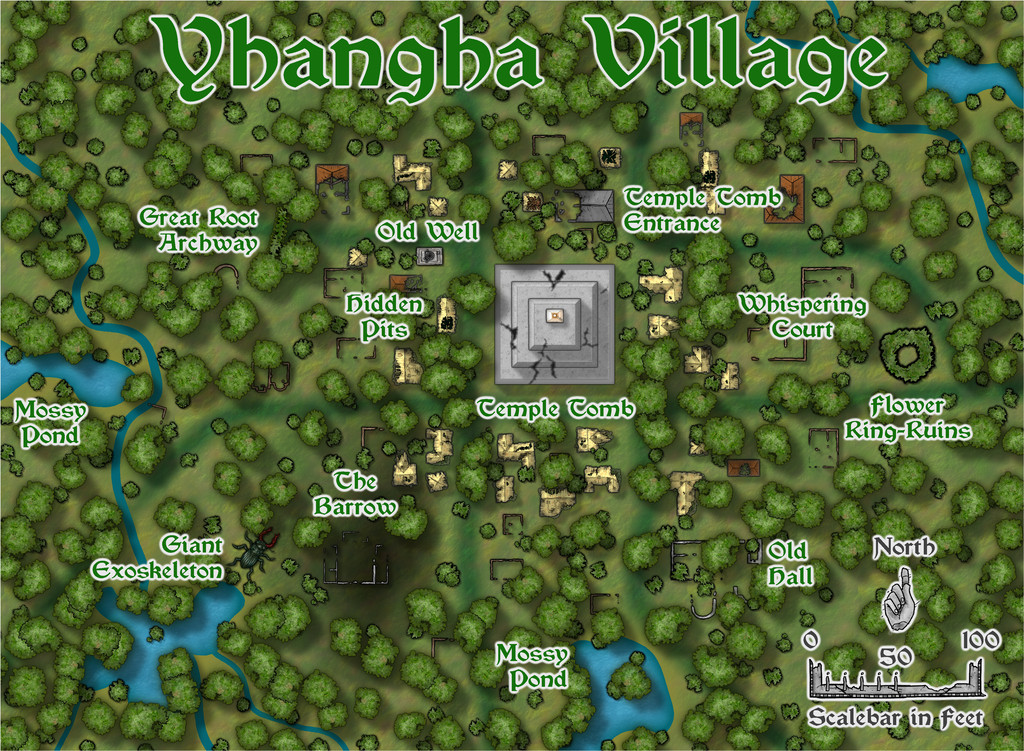
Since the Village is half overgrown by the jungle, it became something of a challenge as to how much could be hidden and how much left still visible. I wanted the old grassed-over trails to disappear into the trees towards the map's edges, though closer to the centre, this became more of a juggling act. If you think the Barrow Temple looks a little strange, and maybe a bit "thin", you'd be right, as it's a semi-transparent ghost building set over its own low-wall ruins. Turn off the "Ghost Temple" toggle in the Atlas FCW file, and it vanishes:
-
Community Atlas: The TlokPik Area of Nga-Whenuatoto
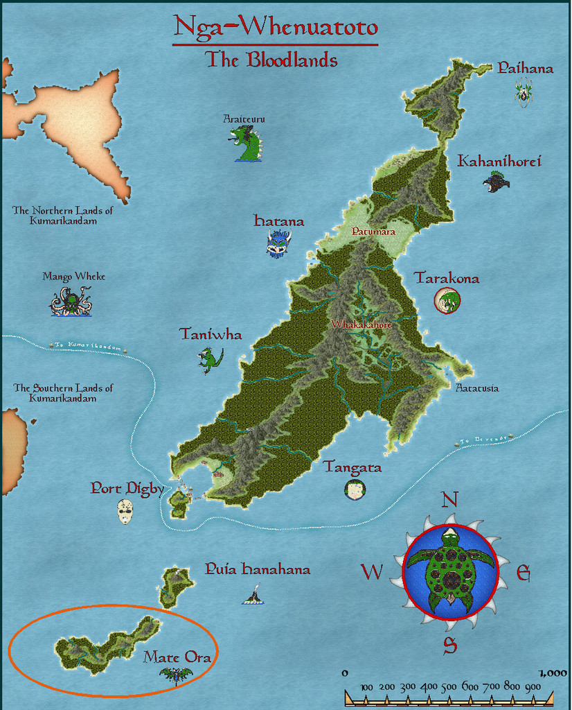
Hopping to the next continent east from my sojourn in Kumarikandam last month, took my sort-of Dungeon24 project (see this earlier topic for details) to the archipelago of Nga-Whenuatoto, and specifically the southernmost island in the chain, Mate Ora, as this was where the third of the Inkwell Dice "Crypts" set of designs had been randomly allocated.
Part of the design the Crypts dice had generated included the interior of a pyramidal structure. Later in the process of rolling-up the full set of base map designs, I discovered that the "Cities" and "Ruins" dice sets had identical patterns, except that the Ruins dice had parts of their designs - as you might expect - in ruins. This created a minor complication, since as mentioned before, I was intending to avoid using duplicates of the same dice design for the full set of base maps. Doing this for the Cities and Ruins sets meant I ended up with just four Ruins designs unused, and as luck had it, each of those had a single major feature on it. Since ruins are a handy feature found on many fantasy maps overall, I opted to add all four of these single-dice drawings to the final set of base maps. One of which was a central ziggurat with the same number of external "steps" as the interior from the Crypts set. So it seemed useful to combine both designs for these Mate Ora maps.
All that remained for the planning stage was to select a suitable ruin on Mate Ora, and I found one in the northeastern part of the island that seemed to fit what I'd begun thinking of:
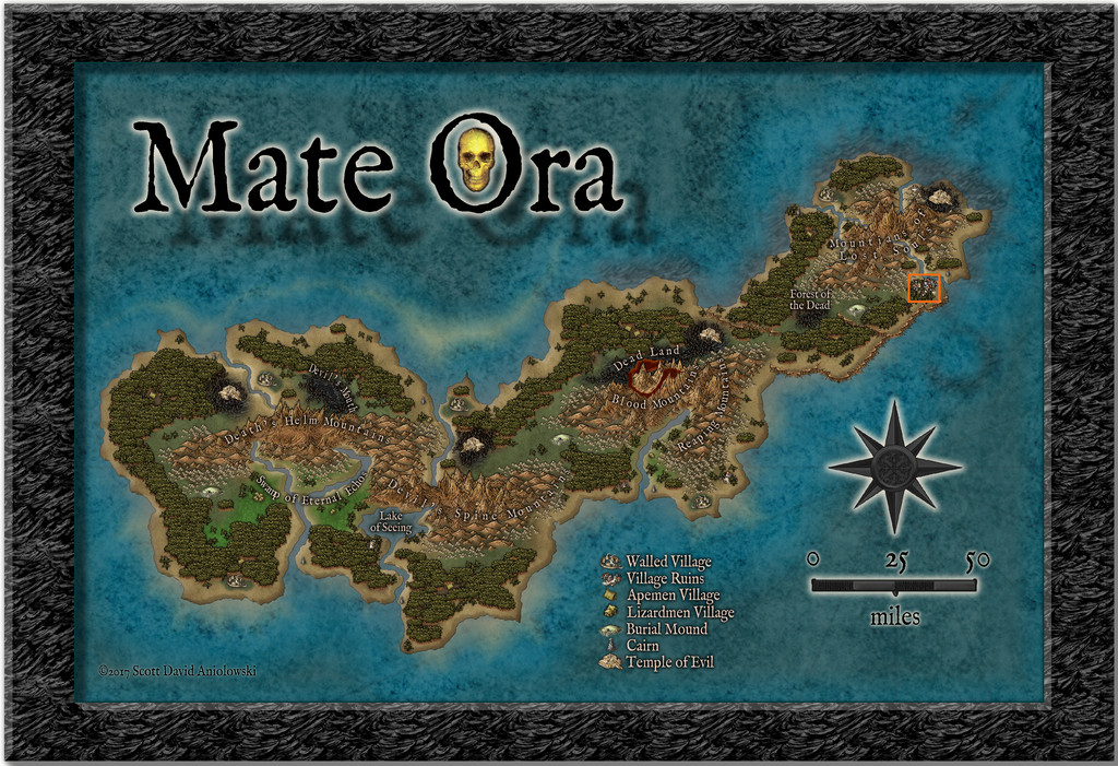
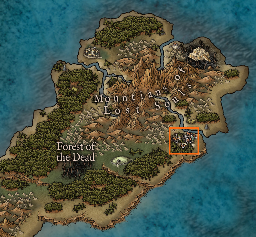
Mate Ora has a reputation as the Land of the (Living) Dead, so it was obvious the tombs here were going to be a little unquiet, and following a few more random rolls on suitable tables, and a bit of consideration, I decided on the primary denizen being a lich, but one who was trapped at the ruin site. From the map scale, it's clear that the orange rectangle shown above is about 9 by 8 miles in size, so the ruined village shown was going to be just one small feature within that area, and that I'd be looking at creating three maps, for the local area, the ruined village and only then the subterranean tombs. There's an ape-folk village just across the sea inlet from my selected site, and it seemed natural they'd have learnt to avoid this area, and would have named it.
I toyed with the idea of something vaguely Maori for the names, given this applies to the rest of the archipelago, only to decide against it, given how isolated and shunned Mate Ora has become, thanks to its fearsome reputation. However, I still wanted something a little out of the ordinary, so thought the ape-folk language might well consist of elements such as tongue-clicks and throaty sounds. So the village became TlokPik, or Yhangha (as the lich prefers), and the local area map took its name from the former version of the village name. As a translation, I went with TlokPik as meaning something like "Jungle hill(s)/burial mounds where the (living) dead walk", and for the ape-folk to treat it as a kind of taboo term, a place to be avoided.
The area map, while based on the terrain shown on the Mate Ora map, had a number of random additions, and others, applied. For this Mate Ora set of maps too, I drew on a broad selection of random table options, some of my own, some from the Atelier Clandestin "Sandbox Generator" used before, some from the Index Card RPG (Master Edition) by Runehammer Games, but still more this time were sourced from two newly-arrived RPG books from Kickstarters that have delivered in hardcopy during the last few weeks, the main Shadowdark RPG rulebook from the Arcane Library and Monte Cook Games' The Weird (which latter is a massive RPG sourcebook of purely random-idea tables).
Thus finally we arrive at the TlokPik Area Map:
As ever, PDF and text notes will accompany this map, to explain a little more what the names refer to. For the map drawing, I needed some overland style jungle options, and settled upon the Myrklund style from the Cartographer's Annual. The options even so are a little limited, but this set does have varicolor versions of the jungle symbols too, which I needed to better highlight some of the specific features.
However, it might be helpful to see a few more styles better able to handle overland areas of this smaller size (less than 20 miles or so in either dimension), with a greater range of symbol options especially. Just two or three other drawings for jungle (not palm!) trees would have been a great help here, I felt, even though I was able to add a small patch of deciduous woods as well, thanks to one of the random rolls.

-
Community Atlas: The Marshmalika Area of Kumarikandam
As these "ghostly" comments may indicate, I'd had a few ideas of my own as to what else could have been happening in the area, partly also drawing on what I'd established for the Sussara Region earlier. One thing I was pretty sure of is that Marshmalika had been the first place attacked when the invaders arrived, given the Bay of Aqesh is a logical landing area, away from the open sea, where storms are more likely, and the most inland section of that would be as good a place as any to begin. I also thought it would be interesting to explore why their main headquarters wasn't on the coast any more, or indeed at an obvious communications centre with a reliable freshwater supply (it's the orange triangle on the Banjar province map in my first post above). Hence the ghosts, which the rank-and-file are most unhappy about. And there are oddly large numbers of poisonous scorpions and snakes where the ghosts are too, which were never found in such profusion previously, or indeed still at other parts away from the old inhabited locations.
So to the small town of Marshmalika itself, or more correctly, its abandoned ruins:
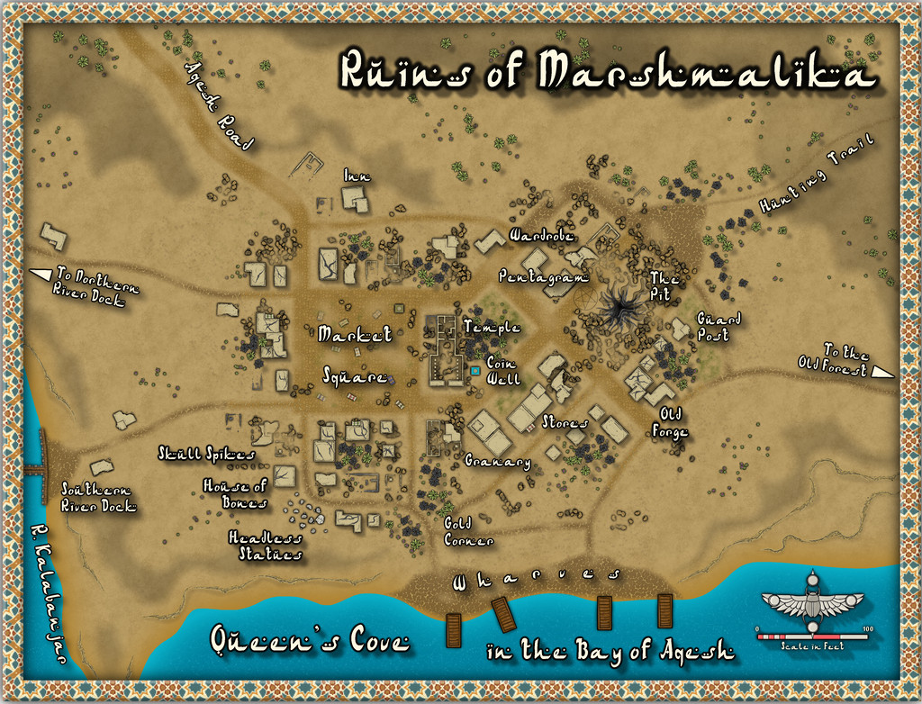
While the style's the same Desert Oasis one as before, other than the sea, I've deliberately muted the choice of other colours here to reflect its ruined status, and had quite a bit of fun creating The Pit and the Pentagram (no, not Pendulum 😉). Hopefully, those will be a little clearer on the higher-res version in my Gallery, and of course, clearer still once in the Atlas. I also chose not to have all the nearby features be on, or fully on, the map, to add to that slightly edgy, uncomfortable feeling, while still keeping it usable as a gaming map. I have to say too, I'm impressed by the versatility of this mapping style, so with just this one Annual issue, it's possible to create a vibrant, living settlement (Sussara Village last time) and an abandoned, ruined one here.
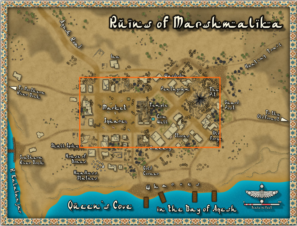
When I started rolling the Inkwell dice sets to generate the base maps for this whole project, I made a few decisions in advance. One was that I wouldn't reuse the same dice-face design twice (I just re-rolled any duplicates), and because I wanted to keep the maps fairly small and manageable, that I'd roll randomly between 2 and 4 dice at a time only. I'd then put together the map based on how the dice fell on the table, once slid together into a whole, naturally. For this "Ruins" set map, I just rolled two dice, and the orange rectangle on this image shows what the dice had set-up:
Most of the major features of the settlement, in fact, as that seemed appropriate. The only real change I made here was that the Temple was originally a group of large, partly or wholly ruined buildings, with trees and an open area in the adjoined block to its right. However, the Desert Oasis style comes with its own ruins, including this one, and it seemed a shame not to use it! The expanded areas were a mix of randomly-rolled options, with logical completions and expansions of roads and trails to fit the landscape around the settlement. Other ruined properties further from the centre aren't shown, as already buried by drifting sand, dust and ash, which is explained in the PDF and text files for the final Atlas version, along with what's going on at the various labelled sites. That House of Bones area is an especially unpleasant reminder that the place was invaded by ruthless folk who cared nothing for the local populace, incidentally (so those sensitive to such things should be warned).
I'm not sure if it's been all this thinking about warfare and ghosts, but my next port-of-call is (as randomly decided) to be on Mate Ora, southernmost of the islands in the Nga-Whenuatoto archipelago, a land where the dead walk, apparently. At least it's still in the southern tropics of Nibirum, so decently warm!
EDIT Feb 3: The eagle-eyed among you may have spotted there were missing internal lines in the Pentagram; images have now been corrected!

-
Community Atlas: The Marshmalika Area of Kumarikandam
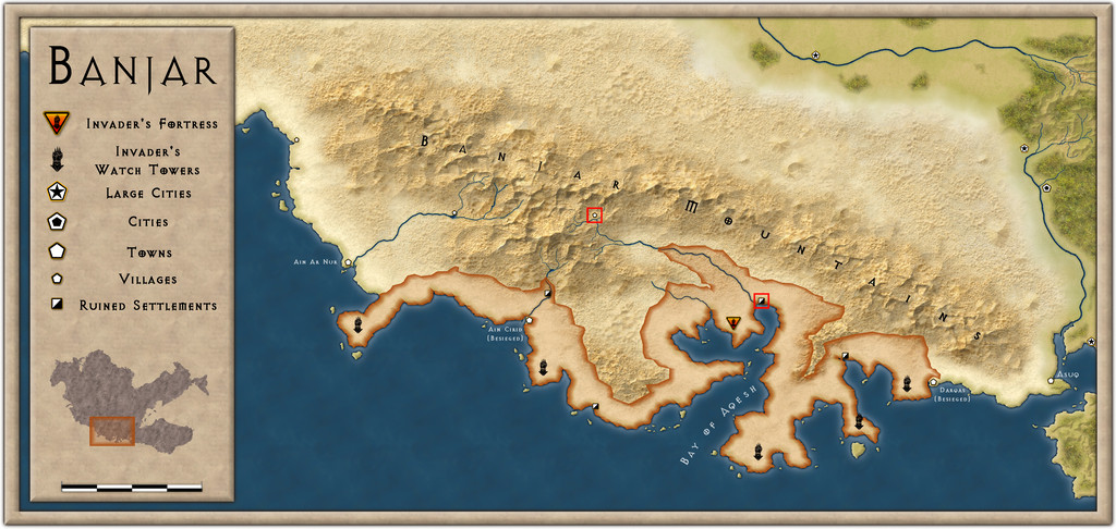
Completing my trip to the Banjar region of Kumarikandam recently, after the Sussara Region, I've now been visiting part of the coast by the mouth of the Kalabanjar River, the tiny red-square-marked ruined settlement at the head of the Bay of Aqesh on the area map from the Atlas (not the one in the mountains - that's Sussara!):
The map I'd generated in advance from the Inkwell Ideas "Ruins" dice set only covered part of the settlement, and given the large scale of the above map, as with the Sussara Region, I knew I'd have to begin with an area map to fit it into anyway. Having already prepared a 20-mile-square map for Sussara, I simply continued the process here, using the same Scorching Sun style for consistency, having generated a list of ideas for features on this map using the same random tables as for Sussara (albeit re-rolling any duplicates with that map), while taking into account the very different circumstances for this part of Banjar - invaded and devastated by incomers in the relatively recent past. Thus we arrive at the Marshmalika Area map ("Marshmalika" = Queen's Cove, incidentally):
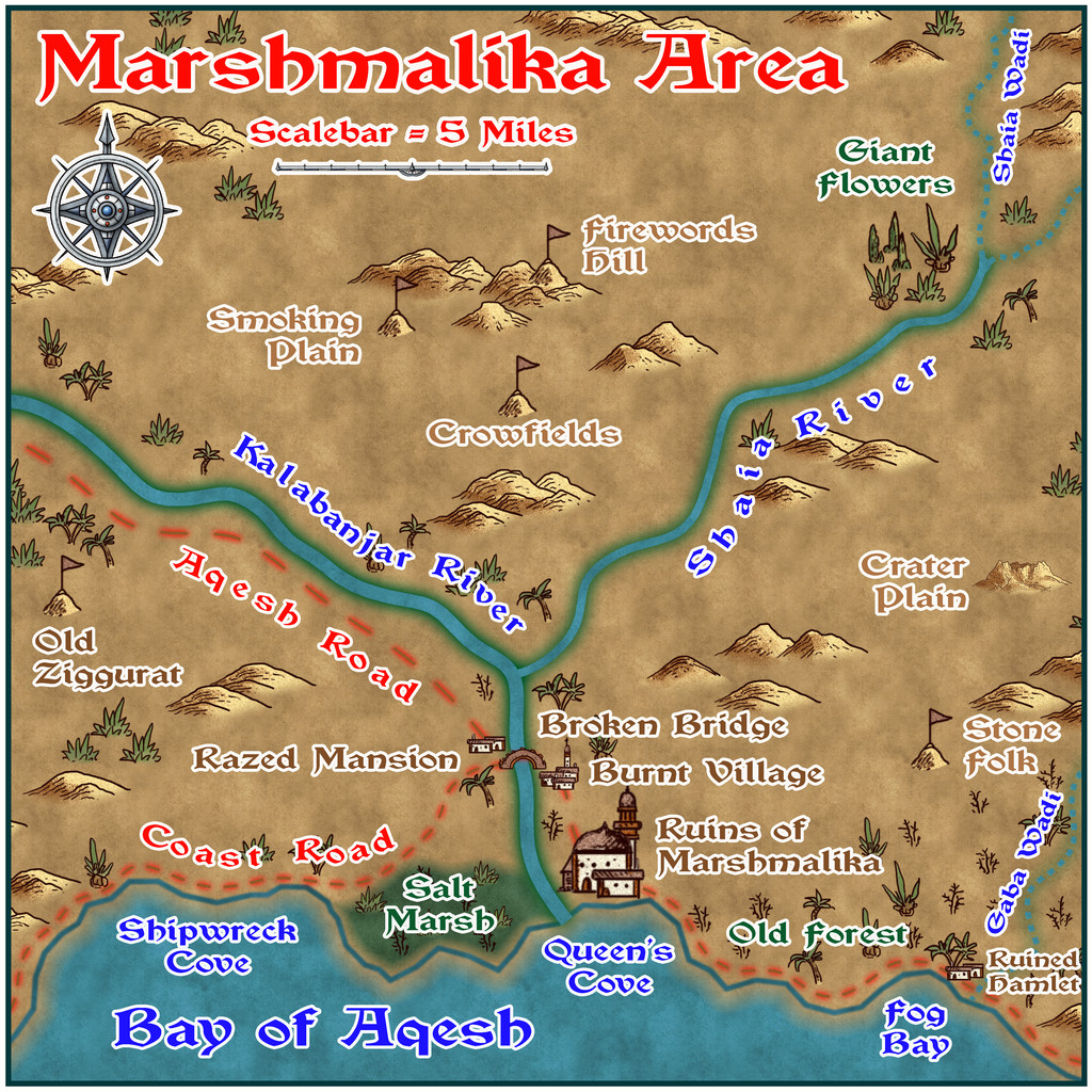
Descriptions of what's where (with how recent some of them are), and the significance of the various items shown will be provided as text and PDF files in the Atlas, as usual, although it's fair to say there are battlefields, and many signs of devastation (not all created by the invaders; war is war, after all). Oh, and there are a LOT of ghosts. They make the invaders feel REALLY uncomfortable, although all they do is stand and stare (mostly). In ever increasing numbers. At any destroyed formerly inhabited place. By day and night, continually. Until the invaders leave.


