


Wyvern
Wyvern
About
- Username
- Wyvern
- Joined
- Visits
- 3,266
- Last Active
- Roles
- Member
- Points
- 5,585
- Rank
- Cartographer
- Badges
- 24
Latest Images


-
Community Atlas: The Haunted Cloud Mesa Area of Kraken Island, Forlorn Archipelago
Switching from the northern tropics of Nibirum's Alarius last time to almost the Antarctic Circle there this (about 60°S), in my ongoing sort-of Dungeon24 project, took me to Kraken Island. Although I have the base sketch ready for the feature map I'm intending in each fresh area, developing ideas to expand that into an actual, if imaginary, place draws on input from that map, possibly some details the accompanying Inkwell Ideas book may have for those of their dice sets that have such, and whatever information the Atlas maps have available already (both maps and text notes). Kraken Island though has very little written about it, and even the maps so far are somewhat vague regarding it.
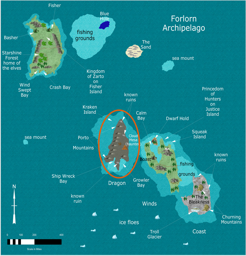
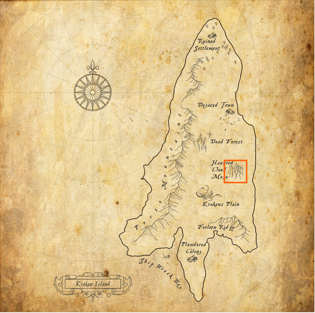
As the second map suggests though, I quickly settled on an intriguing-looking spot, Haunted Cloud Mesa. Krakens' Plain and the somewhat straggly, "undersea" look to the Mesa's symbol set me off down a "watery" route in this case, especially because the small dungeon map I was working with had a stream through it, and the Inkwell book for the dice designs in question (from their "Delver" set, the book being "Dungeonmorph Book of Modular Encounters: Delver, Trailblazer & Voyager Edition") had already suggested some amphibious humanoids could be in residence there.
Ideas clustered in profusion from that, influenced in part by some 15 mm-scale underwater-ish fantasy miniatures from many years previously (almost 25 now...), especially the squidfolk and landsharks, part of a range by the wonderfully-titled Evil Gong Miniatures based in Australia. Not all are imaged there, but the Lost Minis Wiki has more information on the range than most places now, as sadly, I'm not sure Evil Gong are still a going concern. The minis were available in the UK for years from East Riding Miniatures, who started trading in 1999 (Evil Gong started-up around 2000). Unhappily, ERM ceased trading on their owner's retirement in 2021, and Evil Gong seem to have been only on FaceBook since 2019, although the page has been dormant since 2020 apparently (according to the Lost Minis Wiki, as I'm not on FB). They were - maybe still are - based in NSW.
So Haunted Cloud Mesa was going to have spindly (ish), "underwatery" mesa spires, with clouds and mists rising from their tops and valleys, and amphibious/underwater creatures living happily in the air and on the land surface around it. These rapidly came to include (of course!) the squidfolk, called "Plains Krakenfolk" here, and their landshark steeds on Krakens' Plain, along with the gigantic Land Krakens (helping to explain the lack of information on the island, and the few settlements mapped there all apparently being ruined, perhaps), and amphibious Mountain Krakenfolk in the mesa plateau itself. Adding in some transparent deep-sea creatures - Ghost Sharks, Ghost Jellyfish shoals, Ghost Squid and Ghost Giant Octopodes, all flying in air as if swimming in the sea - with some genuine undead ghosts, and suddenly the place was starting to get crowded! After which I decided it needed something a bit more scary still, so added in some Lovecraftian Giant Flying Polyps, which of course are also more or less transparently invisible, as well as hugely inimical to other living things.
When it came to mapping the Mesa, that orange square is about 30 miles per side, and I knew I needed a top-down mapping style so as not to lose too much information on what was supposed to be where. Sketching out some early thoughts, based almost entirely on that single symbol at first, and adding in a series of random features and creatures (using the various sources I've mentioned in previous of these mapping topics), pointed me towards styles that would have hatched contour line markers of some kind. Ultimately, I went with a style I've used before, the Fantasy Realms pack from Annual 26. I did consider the very recently-updated version, but needed the original's hatching options for giving the appearance of flat-topped and stepped hills better. Which brings us to:
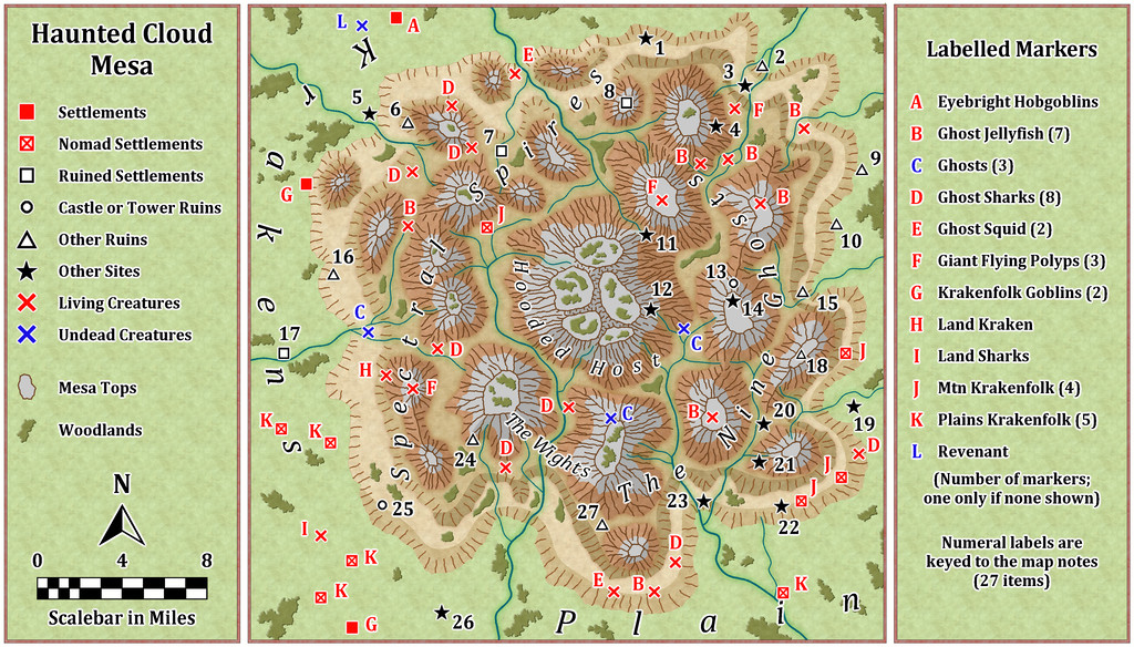
As the right-hand side key panel mentions, the number-labelled sites are detailed in the accompanying PDF and TXT map notes, alongside notes on what the creatures are (the Krakenfolk Goblins are simply the local Goblin-folk; the locals know what they mean by the names, and there aren't many tourists passing through here!).
And if anyone objects to the missing apostrophe in the "Krakens Plain" label here, I have to tell you, it looked far worse when there was an apostrophe out in the middle of nowhere all on its own! "Text along a curve" is great, but unforgiving sometimes...


-
Character Artist_Orc warlord
You can use any assets you have in Character Artist just as you can in any CC3+ drawing, although none of the background symbols used here come with CA3. Not everything will work well necessarily, as some symbols won't enlarge sufficiently without pixelating too much, although it never hurts to experiment.
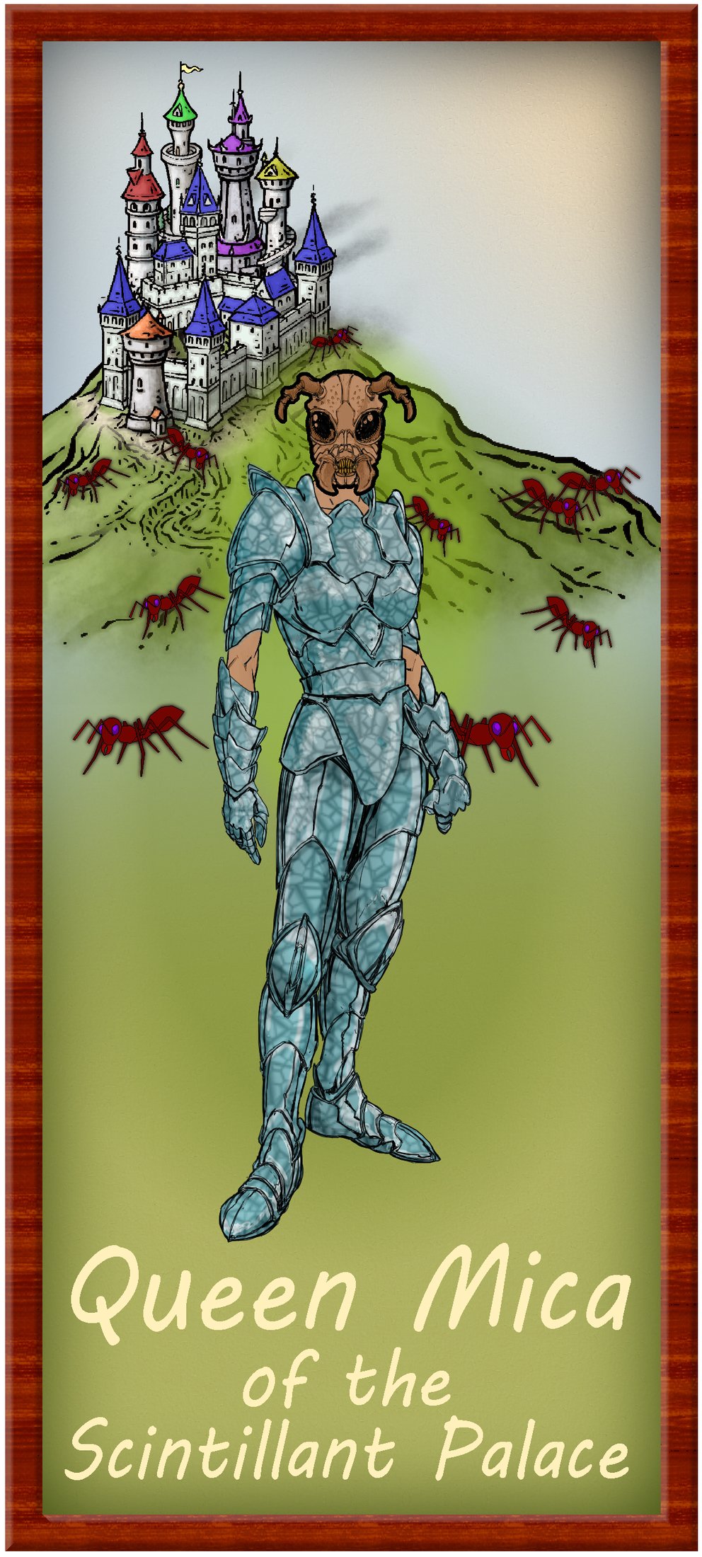
I did something like this with one of my Community Atlas portraits some time back - Gallery image link for Queen Mica. There, the Queen figure is CA3, the "giant" ants are old vector CA symbols, and the hilltop castle is from Mike Schley overland. Add in some colour "washes" and fading glow effects around the figure as required, and maybe some shadows to help separate the back arm from the body, and the front arm from the body as well, etc. (although I didn't use shadows with Queen Mica; it got a little complicated because she can also appear with a human head instead in the drawing!).
-
Community Atlas: The Witch's Valley Head Area in eastern Alarius
Constructing sets of connected maps like this is always an organic process, with ideas for one influencing the other along the way. For these "Crypts" designs, I've been referring to Inkwell's own "Dungeonmorph Delves and Descriptions" book, one of which options has included an order of necromancers that collect strange things from many places, storing them in their own tombs, along with reminders of their greatest leader. Since this chimed with a very long-standing idea of my own from many years ago (it's a useful way of explaining random dungeon layouts sometimes!), I decided to indulge especially heavily from the Inkwell notes for this design, with just a few adaptations and changes, since it all seemed to flow together quite nicely otherwise. Additional elements - notably among the treasures - came from the random tables mentioned in my first posting here, or ideas that occurred along the way. Thus we arrive at The Crypt of the Necromancers map:
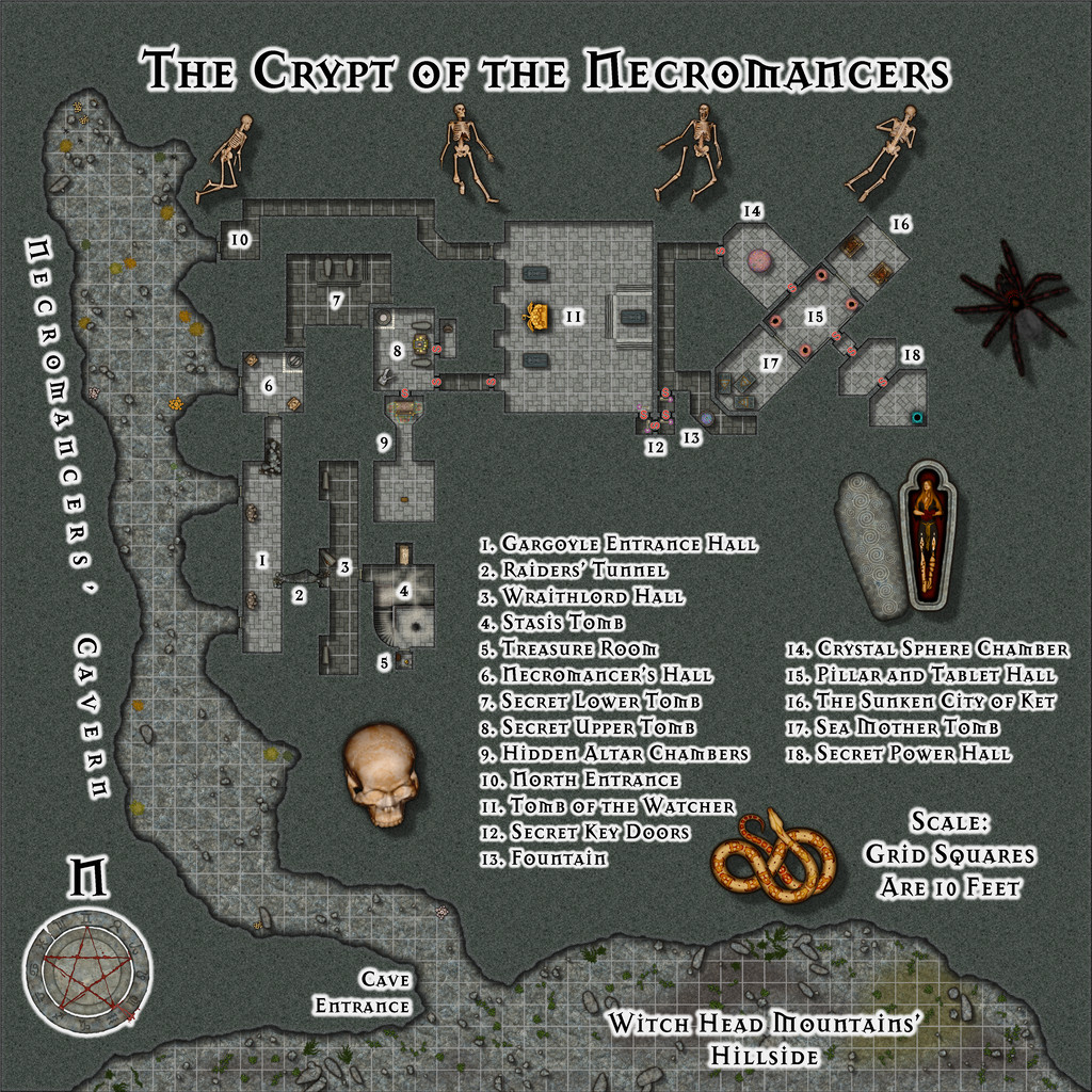
The mapping style is Sue's Creepy Crypts 1 & 2, from Annual issues CA 186 and CA 188, partly because I'd only used elements from it last time, and wanted to try out the complete style, partly because - of course - it's ideal for constructing burial layouts, and partly because it has those really invaluable individual step symbols, perfect for creating daises, or when the mapping design needs a non-standard staircase that rises straight before becoming a quarter-spiral at the top (in room 4 here - hopefully a little more visible on the Gallery version of this map). I've also used a couple of Sue's other symbols in this map, one from her City Domes Annual, CA 144A, the other from the CA 175 Marine Dungeon pack.
The outside, cave entry and long cavern to get to the dungeon proper, were simply sketched-in by hand - and those two blind side passages in the Cavern aren't accidental - after the Crypt layout had been drawn-in. The mechanism for drawing caves in this style is somewhat different to normal, and took a little experimentation to get right, particularly in relation to masking the outside of the Crypt's straighter wall-lines, as that's drawn a different way. And that 10-foot grid was actually drawn on three different sheets as a result of this - some of the lines only by hand!
I knew from the original sketched layout that there'd be space around the design to add a places list (expanded considerably by the text and PDF accompanying Atlas notes), and I opted to indulge further by using more of Sue's Creepy Crypt symbols as decoration to fill some of the spaces this left, and to add to the atmosphere. The coloration is deliberately muted and grey, in-keeping with the generally gloomy aura The Scar region encourages, aside from a Necromancers' Crypt not really being a likely place for bright wallpaper with cute puppies and kittens frolicking over it (though that would rather challenge an adventuring party's expectations)!
The next layout is to be from Inkwell's "Delver" dice set, which has a mixture of cavern and dungeon aspects to the designs. That's scheduled for somewhere on Kraken Island in the Forlorn Archipelago...


-
Community Atlas: The Witch's Valley Head Area in eastern Alarius
Returning to Alarius, if not to my usual part of it, in my Dungeon24-ish project (this previous topic has more information on that), saw me hunting for a suitable location on the Southern Scar Environs map of eastern Alarius, for where to place the fourth and final "Crypts" Inkwell dice design map.
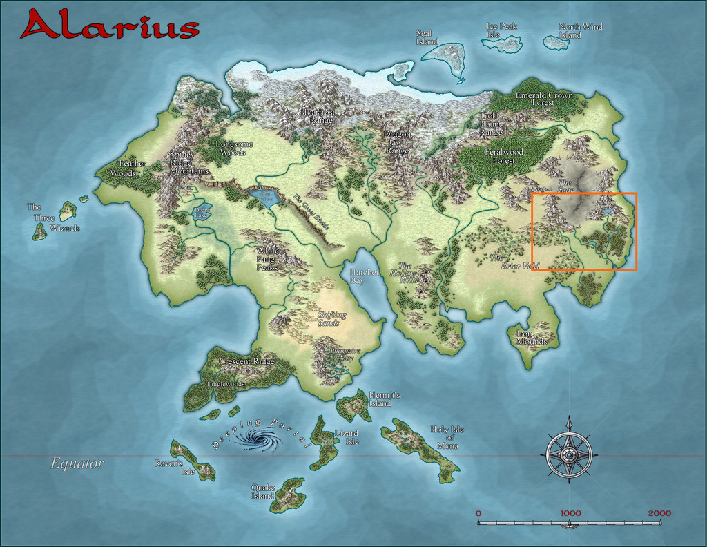
That's a big area, and one affected by the unpleasantly weird effects from The Scar, the linear volcanic feature surrounded by swathes of greyness in the top centre of the orange rectangle in the above illustration. The dungeon design is, by contrast, tiny, although the nature of The Scar, as sketched in the map notes, coupled with the fact this was to be another burial tomb site, had already suggested something undead and/or necromantic as a theme for the subterranean layout. So that narrowed things down somewhat, and ultimately, the site very nearly chose itself, given that one of the few labelled main locations on the Southern Scar map was "Witch's Valley", which had a circle of standing stones set in its midst. Right at the northwestern, mountain-enclosed, end was a cave symbol, so that was that!

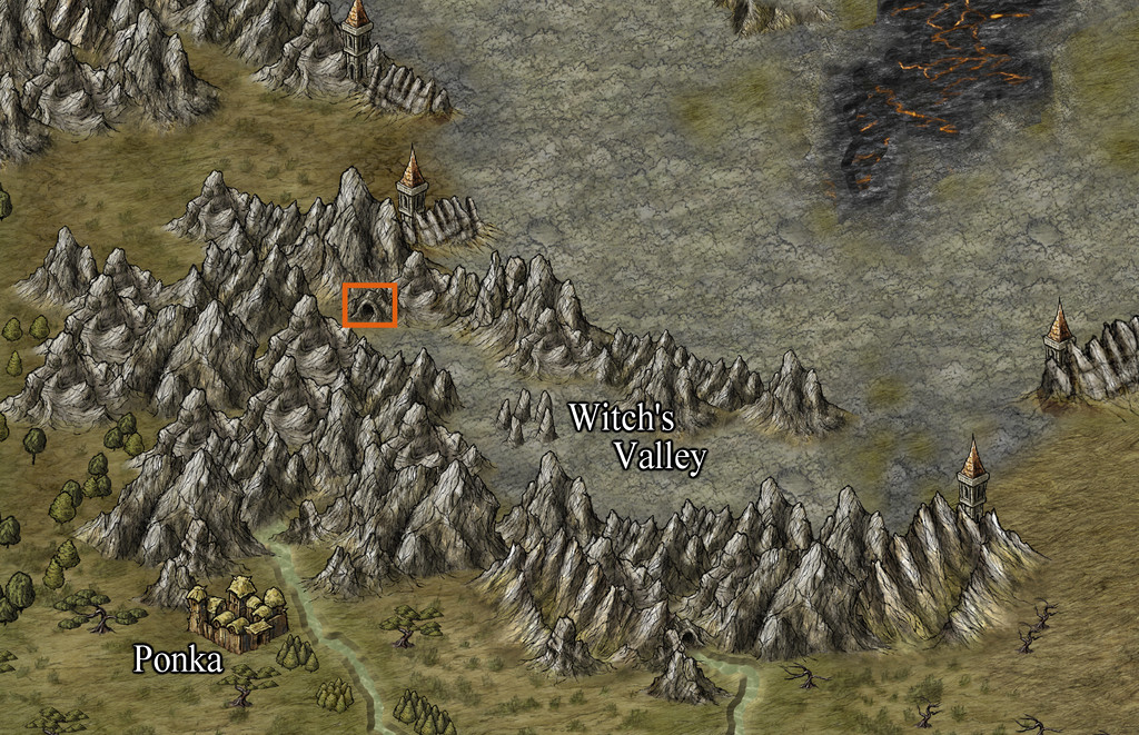
The orange rectangle around the cave is actually 25 miles by 16 in size, so not wanting to simply drop in a little dungeon map there, as has started to become typical for this project, I also needed to devise a suitable area map into which the dungeon design could be fitted. Having sketched the basic features for this onto graph paper, I then added a random selection of additional items from the sources mentioned in my first post last time on Mate Ora, although here, the selections were tweaked to better reflect the negative feeling of this area, so relatively near The Scar - if sometimes with a few hints that things were not always as they now appear here too. Once these feature locations were emplaced, it was possible to draw in a few river and stream lines to fit, since while no major river is shown in Witch's Valley on the Southern Scar map, valleys rarely happen without something of the sort, and the mountainous terrain, plus the near-tropical location (the cave symbol is at roughly 37° N latitude), showed there would be some water channels at least.
Then it was time for the mapping. Several possible overland styles were identified as having a suitably large number of mountain and hill options, of which the DeRust Overland style from Annual 81 seemed a good fit. Thus the Witch's Valley Head map:
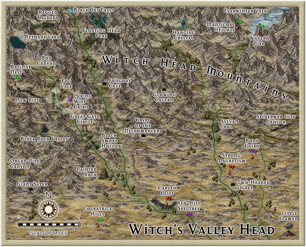
The labelling font is the Mason Serif Alt Bold one that comes with CC3+, as that seemed a comfortably "spiky" fit for this map style. As normal, there'll be PDF and text file notes to provide a few more details on the labelled items in the final Atlas version. While the sites for these were chosen purely randomly, it was pleasing to find they'd clustered more towards the western to northwestern part, given those are the directions of the more imposing, larger, mountain symbols on the Southern Scar map beyond this selected area.

-
New maps of Arkham from Chaosium - free downloads
I know some folks here are keen Cthulhu-esque fans, and some may already know that Chaosium has just released a new "Arkham" supplement for their Call of Cthulhu RPG. When checking the webpage for more details on the book today, I spotted that as quite often, they've made some elements available for free online viewing and downloading (as PDFs), including four new maps, two of Arkham, one of the city's surrounds, and - still more interestingly to me at least - a new map of Massachusetts for 1922 which has on all the main Lovecraftian additional settlements! All these are beautifully done in period style, and you can find the download links here, by scrolling down to almost the end of the page.
There's also a four-page PDF copy of the Arkham Advertiser newspaper available there too, again prepared in period style by the two leading lights of the H P Lovecraft Historical Society, Andrew Leman and Sean Branney, long noted for the excellence of their facsimile period physical products!


