


Wyvern
Wyvern
About
- Username
- Wyvern
- Joined
- Visits
- 3,266
- Last Active
- Roles
- Member
- Points
- 5,585
- Rank
- Cartographer
- Badges
- 24
Latest Images


-
Community Atlas - Forlorn archipelago - The Bleakness, 2 villages and 2 keeps
Glad you'd got the test resolved Jim; not ideal news from the result, obviously, but great to see you were in good spirits, and it can be fixed.
Been offline till today myself, or I'd have commented sooner.
Best of luck for the next appointment, and beyond, naturally.

-
Live Mapping: Parchment City (CANCELLED)
Well, I'm still hunting for the connecting sewer symbols to let me create a sewer layout for Parchment City (hey, it says I can do this on page 1 of the PDF Mapping Guide for it!) 😉😁!
[At a not-so-wild guess, that's an accidental copy-over from the March Annual!]

-
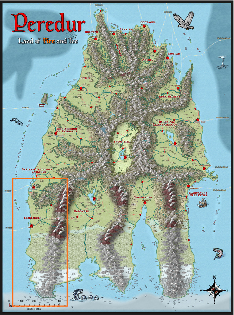
Community Atlas: Gruvrå's Mine, Serkbergen, Peredur
Sure, Jim. I looked around in the Atlas, worked out where there were area maps smaller than continental-size, drew up a list of those, and then rolled some dice to find places to fit the total of 52 maps I had in mind. Duplicates were re-rolled, so no area would get more than one new map. There were more such areas than I needed, so not every place ended up being selected. I also removed a few areas that were quite heavily mapped already (or had reserved sites on them), and there were a couple that were too small to be viable for what I needed.
When it comes time to finding somewhere for the maps to go on the chosen area map, I then just look at the selected area map and pick somewhere that looks suitably interesting in it, maybe in a sub-area map if there's something suitable, or if not, I'll draw something myself, though not more than about 30-40 miles per side at most. In this case, I felt I'd been really lucky to have found a nicely small area map in the Serkbergen region which had some unused interesting features right in its centre; if I'd been drawing the area map myself, I couldn't have aimed it much better!

-
Community Atlas: Gruvrå's Mine, Serkbergen, Peredur
This map was another "two-dice-only" design from the Inkwell Ideas "Delver" set, thus similar in size and proportions to the Oracle Temple one previously on Kraken Island in the Forlorn Archipelago. One novel aspect on this occasion was I found a convenient area map in the Serkbergen region of Peredur into which I could place it, which was unusual in this project so far! This was just as well, since Peredur's quite large anyway, and the Serkbergen map covers a substantial chunk of its southwest.
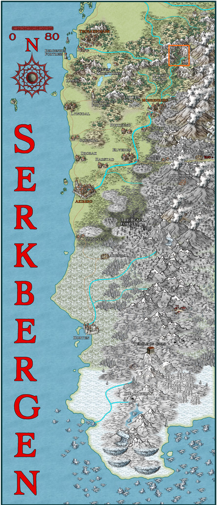
If you peer closely at the orange outline square near the top right on the Serkbergen map image, you'll see where I was aiming towards. A closer view:
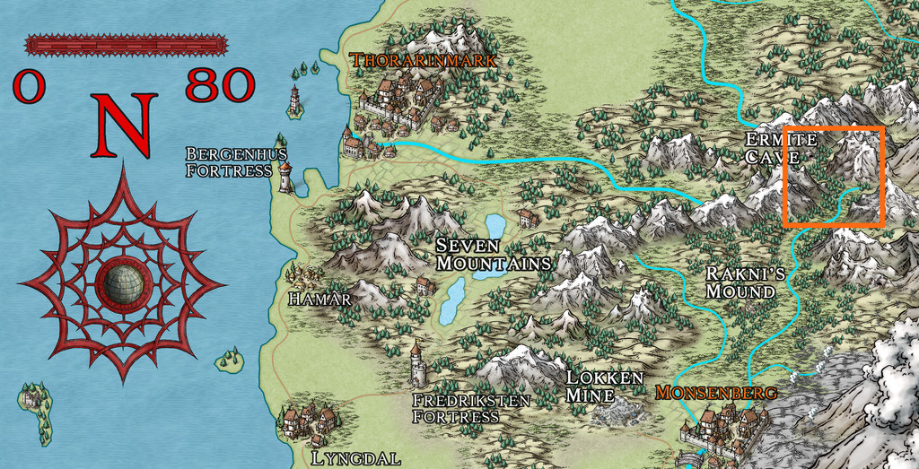
That's the area covered by the Ermite Cave map, and as luck had it, there were some interesting unlabelled mountain spire features near the middle of that map I could simply drop my little dungeon map into:
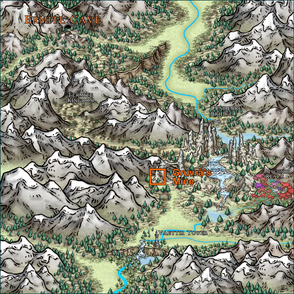
So I did!
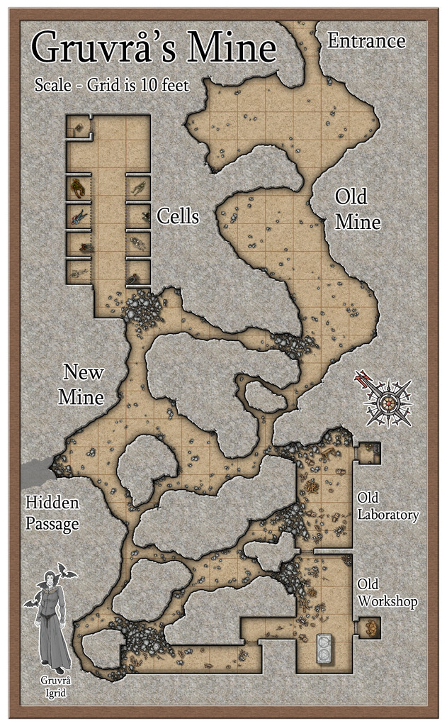
I've mentioned before that ideas for what the contents for each of these maps will be come from various places, typically a combination of what the diced map designs look like, any descriptions available from the accompanying Inkwell Ideas books, a range of random tables from various sources, and where the map will be located on Nibirum. Here, it was the influence of the high southerly location (within Nibirum's Antarctic Circle, roughly 71°S latitude), coupled with the name of Vaettir Tower about eight miles south of the Mine. Having picked-up a copy of Free League's "Vaesen" RPG last year, and a copy of the illustrated book by Johan Egerkrans that inspired it, also called "Vaesen", I knew what "Vaettir" meant from Scandinavian folklore, so I thought that source would be a good place to look for further thoughts. A couple of ideas came from the Inkwell book too - including having undead creatures out for revenge in what's marked as "Cells" on the map, and the dangerous state of some of the caves, although the risky look of the caves on the dice designs had already indicated this latter point as of some significance. I flipped through the Egerkrans book, and settled on the Mine Guardian Spirit, or Gruvrå, as the main actor in this place, although unfortunately, this is one of the creatures in that book which didn't make the cut into the Vaesen RPG (or hasn't so far). So I simply elaborated on what was said about her in the folklore tome instead. A couple of random rolls on tables from Monte Cook Games' "The Weird" - creating a gem-studded, tattooed Golem with a horned cat's head - and everything started to fall into place!
What I came up with, detailed in the map notes for the Atlas, as ever, is an old Dwarf Mine that ended up abandoned, and which was then expanded and altered by a group of inventors and alchemists determined to create a "better" Golem, using body parts from captured humanoids, possibly making them a variant kind of magical undead in the process (hence the need for a secret lair). After the Mine was abandoned, the Gruvrå's attention went elsewhere in her realm (which I decided would encompass all those interestingly spire-like mountains arcing away towards the Myconid Realm on the area map), so it was only sometime later she returned to the old Mine. Horrified at what she found there, she destroyed the Laboratory and Workshop, and drove out or killed the perpetrators. It's really easy to anger a Gruvrå if you fail to show one the proper respect. However, she didn't understand the undead creatures, so just left them, and the last Golem as well. Plus of course, she now keeps a closer watch on this old Mine than she used to.
I also felt I needed a CA3 portrait of the Lady in question, now named as Igrid, thus creating a thumbnail that could be added to the map, as the perceptive among you will have realised already! This is the full portrait, which was heavily influenced by the Egerkrans drawing:
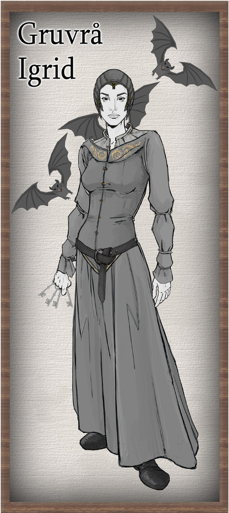
The keys and bats came from the old vector CA, since CA3 doesn't include such features. I might have added a lamp too, but neither version of CA has one of those, sadly. The bats I decided are essentially merely small aspects of the Lady, able to flit about quickly, to help keep her better informed of events in her realm. They're not "real" bats beyond that. If she appears in a black dress, that's a sure warning of impending death for someone; grey like this is her normal attire. I decided against providing that change as an option in the Atlas map though. Seemed a bit too grim.
In case anyone's unsure, the Mine map was drawn using the SS4 Mike Schley Dungeons set. I've used this before, though not for a long while, and thought it would work nicely for the somewhat dangerous, partly collapsed layout here, as it has such a fine collection of rubble and rockfall markers, aside from other features. Thanks to the Gruvrå's colouring being very greyscale overall, I did want a more washed-out, aged and worn look to the map as well, so this all just seemed to work ideally for that impression. I also wanted it to be a little off-kilter, so you'll notice the squared areas don't quite fit to the grid lines. That's quite deliberate, and isn't simply a means to annoy those using the map in VTTs - that's just an added bonus 😉!
For the next map in this sort-of Dungeon24 set, I'm being randomly guided back to Alarius, and this time quite close to my "usual" territory there, as it's to go on the adjoining North Central Alarius map...


-
Community Atlas: The Haunted Cloud Mesa Area of Kraken Island, Forlorn Archipelago
With the area map done, and near-central Site 12 selected as the location for the Oracle Temple map created from the dice throws, I thought it might be interesting to try to tie the mapping style up with what the Fantasy Realms one was based on originally, which was that used in the 3rd Edition "Forgotten Realms" D&D published products. I'd hoped to provide an illustration here to show what I mean by this for the dungeon-scale maps, but I've struggled to find anything suitable online, and while I have a couple of PDF books from that era (when I was too deep in my long-standing interest in many other RPG systems than D&D to collect D&D books!), I'm dubious about reusing something from those here on copyright grounds. Plus, a lot of the subterranean maps in this style seem uncomfortably dark and hard to read to me (in the PDFs at least). They do though have a couple of interesting quirks. Walls have a consistently "hand-drawn-wobbly" look, and are highlighted further by use of closely-ruled lower left to upper right hand-drawn hatching strokes, while the scaling grid is a double one, with heavier 10-foot squares subdivided internally into 5-foot ones.
Having randomly opted for just two dice designs for this map, I felt I could probably cope with this for a small area, and set about pulling together a sort-of new style, using elements from both the Fantasy Realms Annual (as the textures in the 3rd Ed dungeon maps have a similar look to the overland maps) and the Old School Dungeon style from Annual 12, the latter mostly for the symbols, though in the end, I only used two of those, and one of them was a repurposed door! The map:
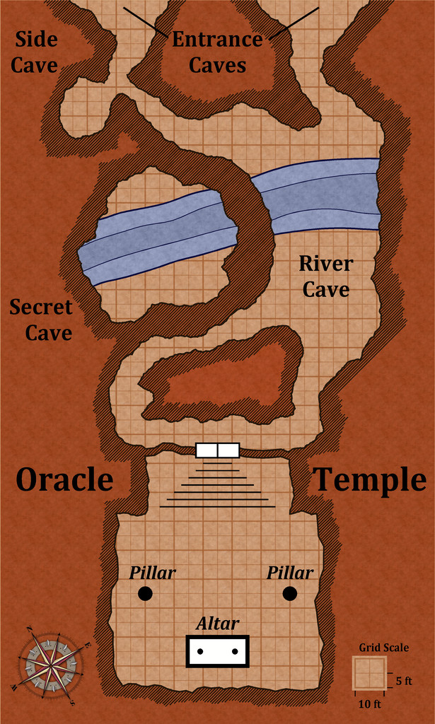
The only further addition was the Alyssa Faden style's compass rose, which is a closer approximation to the 3rd ED one than any others I could find. Most of the map is simply hand-drawn, including all those ruled hatching lines (hey, the Mesa map was mostly hand-drawn too, so I was in practice!).
For a more formal style, the hatching could doubtless be done with a suitable bitmap fill of tile-able ruled lines with transparent gaps between, the polygon tool set up to be drawn fractally, and the colouring of the texture bitmap fill adjusted to fit this reddish-brown theme (which is very characteristic - the original was notably darker than this; I've deliberately aimed for lighter tones). To achieve this colouring here, I've used two different fills, one atop the other, one reddened with an RGB Matrix effect, the other made partly transparent, and then punched holes through both with a Color Key effect to show floors and grid (which latter is on two different sheets to help thicken up the 10-foot squares a little more). There would need to be one more darker blue water fill as well in a fuller style version, as some of the original maps showed up to three deepening water contour levels.
Although the doors in the "real" style were always shown as they are here, elements such as the altar were drawn in a similar brown colour to the background fill, which again I find hard to read (is it a room feature or just a rectangular rock pillar?). However, I was happy with this final result as being close enough to the original to work - to my eye anyway! It's much the same sort-of look to how the Fantasy Realms style is to the published Forgotten Realms overland maps, at least.
Next time, I'm slipping sideways to the left in Nibirum to find somewhere to drop in a little dungeon to somewhere in Serkbergen, Peredur!

