

Community Atlas: The Haunted Cloud Mesa Area of Kraken Island, Forlorn Archipelago
 Wyvern
🖼️ 293 images Cartographer
Wyvern
🖼️ 293 images Cartographer
Switching from the northern tropics of Nibirum's Alarius last time to almost the Antarctic Circle there this (about 60°S), in my ongoing sort-of Dungeon24 project, took me to Kraken Island. Although I have the base sketch ready for the feature map I'm intending in each fresh area, developing ideas to expand that into an actual, if imaginary, place draws on input from that map, possibly some details the accompanying Inkwell Ideas book may have for those of their dice sets that have such, and whatever information the Atlas maps have available already (both maps and text notes). Kraken Island though has very little written about it, and even the maps so far are somewhat vague regarding it.
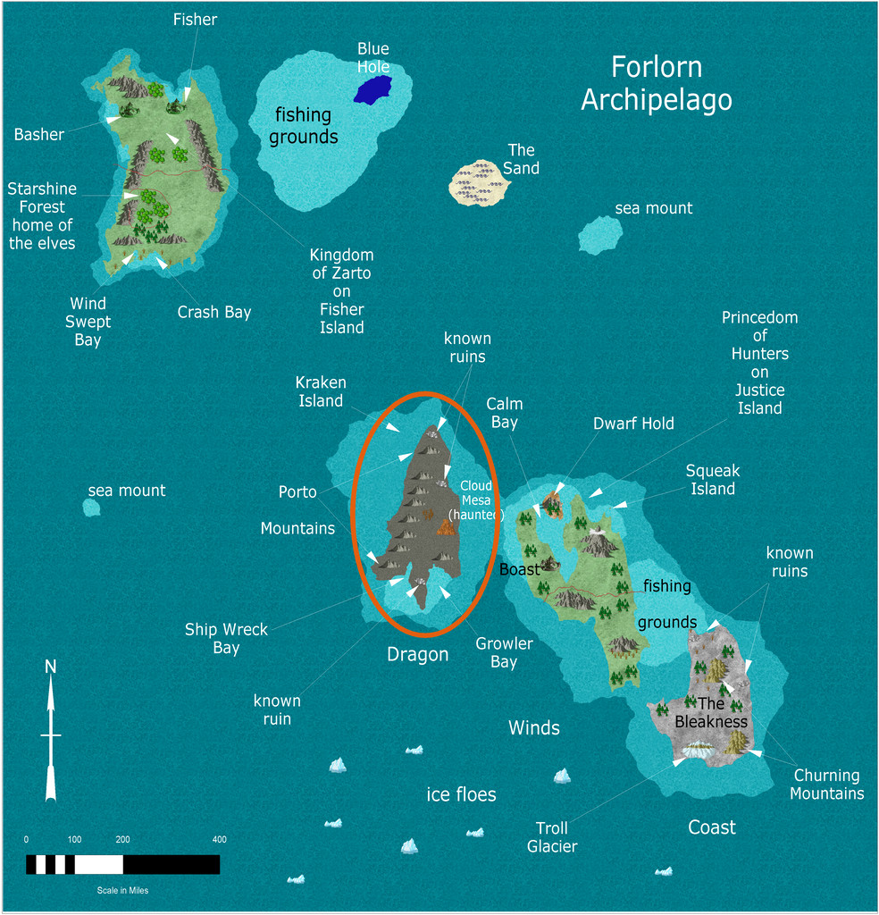
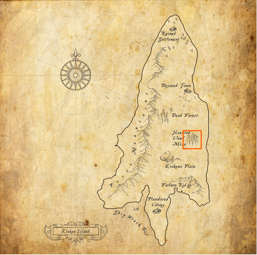
As the second map suggests though, I quickly settled on an intriguing-looking spot, Haunted Cloud Mesa. Krakens' Plain and the somewhat straggly, "undersea" look to the Mesa's symbol set me off down a "watery" route in this case, especially because the small dungeon map I was working with had a stream through it, and the Inkwell book for the dice designs in question (from their "Delver" set, the book being "Dungeonmorph Book of Modular Encounters: Delver, Trailblazer & Voyager Edition") had already suggested some amphibious humanoids could be in residence there.
Ideas clustered in profusion from that, influenced in part by some 15 mm-scale underwater-ish fantasy miniatures from many years previously (almost 25 now...), especially the squidfolk and landsharks, part of a range by the wonderfully-titled Evil Gong Miniatures based in Australia. Not all are imaged there, but the Lost Minis Wiki has more information on the range than most places now, as sadly, I'm not sure Evil Gong are still a going concern. The minis were available in the UK for years from East Riding Miniatures, who started trading in 1999 (Evil Gong started-up around 2000). Unhappily, ERM ceased trading on their owner's retirement in 2021, and Evil Gong seem to have been only on FaceBook since 2019, although the page has been dormant since 2020 apparently (according to the Lost Minis Wiki, as I'm not on FB). They were - maybe still are - based in NSW.
So Haunted Cloud Mesa was going to have spindly (ish), "underwatery" mesa spires, with clouds and mists rising from their tops and valleys, and amphibious/underwater creatures living happily in the air and on the land surface around it. These rapidly came to include (of course!) the squidfolk, called "Plains Krakenfolk" here, and their landshark steeds on Krakens' Plain, along with the gigantic Land Krakens (helping to explain the lack of information on the island, and the few settlements mapped there all apparently being ruined, perhaps), and amphibious Mountain Krakenfolk in the mesa plateau itself. Adding in some transparent deep-sea creatures - Ghost Sharks, Ghost Jellyfish shoals, Ghost Squid and Ghost Giant Octopodes, all flying in air as if swimming in the sea - with some genuine undead ghosts, and suddenly the place was starting to get crowded! After which I decided it needed something a bit more scary still, so added in some Lovecraftian Giant Flying Polyps, which of course are also more or less transparently invisible, as well as hugely inimical to other living things.
When it came to mapping the Mesa, that orange square is about 30 miles per side, and I knew I needed a top-down mapping style so as not to lose too much information on what was supposed to be where. Sketching out some early thoughts, based almost entirely on that single symbol at first, and adding in a series of random features and creatures (using the various sources I've mentioned in previous of these mapping topics), pointed me towards styles that would have hatched contour line markers of some kind. Ultimately, I went with a style I've used before, the Fantasy Realms pack from Annual 26. I did consider the very recently-updated version, but needed the original's hatching options for giving the appearance of flat-topped and stepped hills better. Which brings us to:
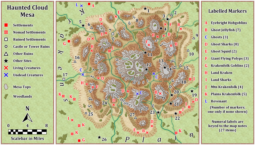
As the right-hand side key panel mentions, the number-labelled sites are detailed in the accompanying PDF and TXT map notes, alongside notes on what the creatures are (the Krakenfolk Goblins are simply the local Goblin-folk; the locals know what they mean by the names, and there aren't many tourists passing through here!).
And if anyone objects to the missing apostrophe in the "Krakens Plain" label here, I have to tell you, it looked far worse when there was an apostrophe out in the middle of nowhere all on its own! "Text along a curve" is great, but unforgiving sometimes...


Comments
With the area map done, and near-central Site 12 selected as the location for the Oracle Temple map created from the dice throws, I thought it might be interesting to try to tie the mapping style up with what the Fantasy Realms one was based on originally, which was that used in the 3rd Edition "Forgotten Realms" D&D published products. I'd hoped to provide an illustration here to show what I mean by this for the dungeon-scale maps, but I've struggled to find anything suitable online, and while I have a couple of PDF books from that era (when I was too deep in my long-standing interest in many other RPG systems than D&D to collect D&D books!), I'm dubious about reusing something from those here on copyright grounds. Plus, a lot of the subterranean maps in this style seem uncomfortably dark and hard to read to me (in the PDFs at least). They do though have a couple of interesting quirks. Walls have a consistently "hand-drawn-wobbly" look, and are highlighted further by use of closely-ruled lower left to upper right hand-drawn hatching strokes, while the scaling grid is a double one, with heavier 10-foot squares subdivided internally into 5-foot ones.
Having randomly opted for just two dice designs for this map, I felt I could probably cope with this for a small area, and set about pulling together a sort-of new style, using elements from both the Fantasy Realms Annual (as the textures in the 3rd Ed dungeon maps have a similar look to the overland maps) and the Old School Dungeon style from Annual 12, the latter mostly for the symbols, though in the end, I only used two of those, and one of them was a repurposed door! The map:
The only further addition was the Alyssa Faden style's compass rose, which is a closer approximation to the 3rd ED one than any others I could find. Most of the map is simply hand-drawn, including all those ruled hatching lines (hey, the Mesa map was mostly hand-drawn too, so I was in practice!).
For a more formal style, the hatching could doubtless be done with a suitable bitmap fill of tile-able ruled lines with transparent gaps between, the polygon tool set up to be drawn fractally, and the colouring of the texture bitmap fill adjusted to fit this reddish-brown theme (which is very characteristic - the original was notably darker than this; I've deliberately aimed for lighter tones). To achieve this colouring here, I've used two different fills, one atop the other, one reddened with an RGB Matrix effect, the other made partly transparent, and then punched holes through both with a Color Key effect to show floors and grid (which latter is on two different sheets to help thicken up the 10-foot squares a little more). There would need to be one more darker blue water fill as well in a fuller style version, as some of the original maps showed up to three deepening water contour levels.
Although the doors in the "real" style were always shown as they are here, elements such as the altar were drawn in a similar brown colour to the background fill, which again I find hard to read (is it a room feature or just a rectangular rock pillar?). However, I was happy with this final result as being close enough to the original to work - to my eye anyway! It's much the same sort-of look to how the Fantasy Realms style is to the published Forgotten Realms overland maps, at least.
Next time, I'm slipping sideways to the left in Nibirum to find somewhere to drop in a little dungeon to somewhere in Serkbergen, Peredur!
Thanks for working on that map !
You're welcome, Jim (although it was decided for me by the dice!).
It has been a bit of a surprise during this little project so far to find that some places on Nibirum have been quite heavily mapped, others hardly at all. That does mean there's still plenty of scope for many other people to join in and add more maps in the less well-known places, of course 😁.
Maps now added to the atlas. Thanks Wyvern.
Thanks Remy!
Just one thought though - the grid's missing from the Atlas images for Oracle Temple. The little square key for it's there, just not the map grid.
That's the standard for all images in the atlas. I export them without a grid so people can use them in VTT's. An existing grid grid in the image often makes issues. Since you cannot turn on/off the grid in an image like in the fcw, I find the gridless versions more versatile for the image (and no, I am not going to publish two different versions of the images on the website).
For users of the actual atlas, they can just toggle it in the fcw.
The square is still there because it wasn't on the GRID sheet. (Which is actually fine, because a visible square helps VTT users to tune the in-software grid.)
Ah right, hadn't realised that Remy. Thanks for the explanation!