


mike robel
mike robel
About
- Username
- mike robel
- Joined
- Visits
- 4,196
- Last Active
- Roles
- Member
- Points
- 435
- Rank
- Surveyor
- Badges
- 6
Latest Images


Reactions
-
Here I go again ...
After many years of trying to find out how to buy current German topographic maps, I finally did so and bought the 8 1:50000 maps that make up the core region of the battle area for my game. As a comparison of the difference of the two, the first shot is the 1:100000 map which has a rectangle in blue showing the area of the 1:50000 map. The second map is the 1:50000 map itself. A little test showed it is much easier to zoom into the 1:50000 map and manipulate it to draw the game map over it.
Physically, both maps are the same dimensions, but of course, the 1:100000 map covers 4 times the area.
The next thought was how to combine the maps.
Option 1. Cut them and scan them individually (requiring four scans per map and then assembly them), compose each set of 4 into a single map, cut the digitally to remove excess material, then combine them digitally to make the final map.
Option 2. Cut them and assemble them manually, then scan them in sections with the hand held scanner I bought which will do 8 inch x 68 inch sections), then combine the scans.
I think it will be easier to assemble the maps manually, and then scan them in sections, then combine them to make the final map. Since the maps are trapezoids and I can only crop or select in a rectangle, it should be easier to assemble them. But I will probably scan them as for option 1 as a back up.
The game map size will be smaller this way and therefore cheaper to reproduce in 11 x 17 inch sections for play.
The hexes will be 3 km wide, but they will physically be larger on the new map, making it easier to move counters around. I will be able to test on my original map since the hex size is what is important, not the actual size.
Does anyone know of an application that will allow one to define a trapazoid rather than a rectangle to select/crop an image?
-
How Can I Draw Real-World Places in Campaign Cartographer?
Well, you might look at this thread to follow my trepidations. It was quite a journey and the people on the board provided a lot of help. I frankly don't remember how I did a lot of things, but perhaps it will be helpful. I am still working on this game, after about 15 years, but the map work is mostly done.
I have made some changes since the thread terminated by hiding some roads and streams to simplify the map and reduce clutter. The game counters are larger, but the hexes are still 3km.
The map covers a region of 88km x 70km and the physical map itself is about 176cm x 140cm in 1:50000 scale. A grid square on the map is 2cm x 2cm, but because of the mapping convention, they sometimes become triangles to conform to the earth's surface.
If you are not using a topographic map, your work should be somewhat easier than mine was.
Of course, all it may do is confuse you. I don't have CC3+ on my computer at the moment and it has actually been a very long time since I made a map.
-
How Do You Find the Right Symbols for Your Maps?
Well, I think I can help you.
Go to https://spatialillusions.com/unitgenerator/ and you should see "Symbol Set" and it shows Land Unit.
Then click on the Land Unit and select Land Installations
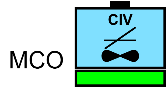
In the upper left you see a large blue rectangle with a small black box on the top.
Go to Main Icon, click the drop down and you will see a lot of possibilities. Scroll down until you get to Airport
Then just explore the various drop downs.
Go to the bottom and you will see Show Additional Options and you will get some 'standard colors" but there is also a place on the right that you can select custom colors. In this case I indicated it is a Civil Airport, the name is MCO (Orlando International Airport, but it was original McCoy AFB), and it is fully capable.
Once you are satisfied with the symbol, you click png to save it to your computer. The icon will then be very large, but you can use a graphics program to change the size, and then save it with an appropriate name.
I suppose you could make a special symbol set that has all the symbols you want and then reduce the size in CC3+ rather than having a bunch of different sizes.
If you want to know more about the symbols, you can go here: https://www.jcs.mil/Portals/36/Documents/Doctrine/Other_Pubs/ms_2525d.pdf or you can search for Army Field Manual 1-02.2 Military Symbols. You should be able to download it from the Army Publication Site or other sites. IT will show examples for many symbols.
Tom's stuff is good, but I think the above is better, but since it is based on text, I think it is less flexible and sometimes does funny things. I used it a lot until I discovered these sites.
I'm sorry I failed to understand you were more interested in installation symbols rather than tactical symbols.
