


Wyvern
Wyvern
About
- Username
- Wyvern
- Joined
- Visits
- 3,266
- Last Active
- Roles
- Member
- Points
- 5,585
- Rank
- Cartographer
- Badges
- 24
Latest Images


-
[WIP] Community Atlas: Oracle Mountains Area, Ruma Helrevy, Peredur
Part of the purpose of this whole not-any-more-it-isn't-Dungeon24 project, was to have the chance to try out new styles and mapping ideas along the way. Something I realised early on though was that it would be difficult to use an isometric style, because the base dungeon maps I was using were all drawn top-down, often with complex features that the extant isometric dungeon-mapping options wouldn't manage. Even so, I'd been trying to find a way to use at least one of the options before now, without success.
Fast-forward to Quezzal Tower, however, a map that didn't exist in any form at all before I began, except as a vague idea, for which I thought it would be an interesting opportunity to finally use one of the isometric options from the Cartographer's Annual. Hence partly why I've decided to present the maps from this group as a WIP on the Forum here, something I don't often do otherwise. It proved to be rather a challenge overall, partly because of the very limited symbol options, mostly because of my unfamiliarity with this style of mapping. It's also something our sadly missed Forum mapping friend JimP kept experimenting with himself; and indeed, I was reminded of some of his comments and struggles with it during my own battles!
I decided on using the CA66 Isometric Dungeons style by Herwin Wielink, and started by re-reading the PDF mapping guide for it. This recommends doing a trial map before embarking on the full-sized version, both to get a feel for the style, and as a means to better estimate the size of mapping area needed. So I did:
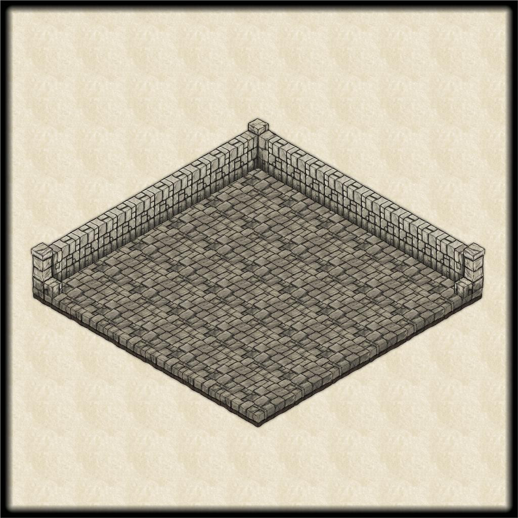
I'd worked out in advance that the surface level of the Tower needed to be about 60 feet square, based on the first part of the subterranean map, with its square entrance chamber, as noted previously in this topic, so I set a size a bit bigger than that as a square map border for this initial trial. Naturally, this is very basic as a drawing, just a floor area comprising 10-foot-square symbols, plus some 5-foot wall pieces and corners. The front walls have been left off here, as this had already given me the information I needed on the general mapping area required.
My original thought had been for the Tower to be around 60 or 70 feet tall, and to taper-in as it rose. With this first experiment, that gave a ballpark figure for what size the mapping area should be, estimated as somewhat larger, as I find it's easier to shrink down a map's area than expand up (usually using the Stretch command, adjusting the map border, any frame and the background). So this is what I did, with the opening segments sketched-in to give a sense of scale:
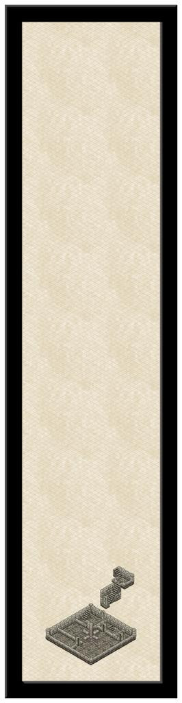
This may seem a bit odd, which is not surprising! A closer look at the mapped segments:
This was mostly because I started the wrong way round, except it was actually the right way! I wanted to show the initial part of the underground level on this map too, but I first needed to know what the surface level of the Tower's layout would look like, so as to work out how to fit the descending stairwell into that. Hence the subterranean stairwell currently hangs in the air above the surface level plan.
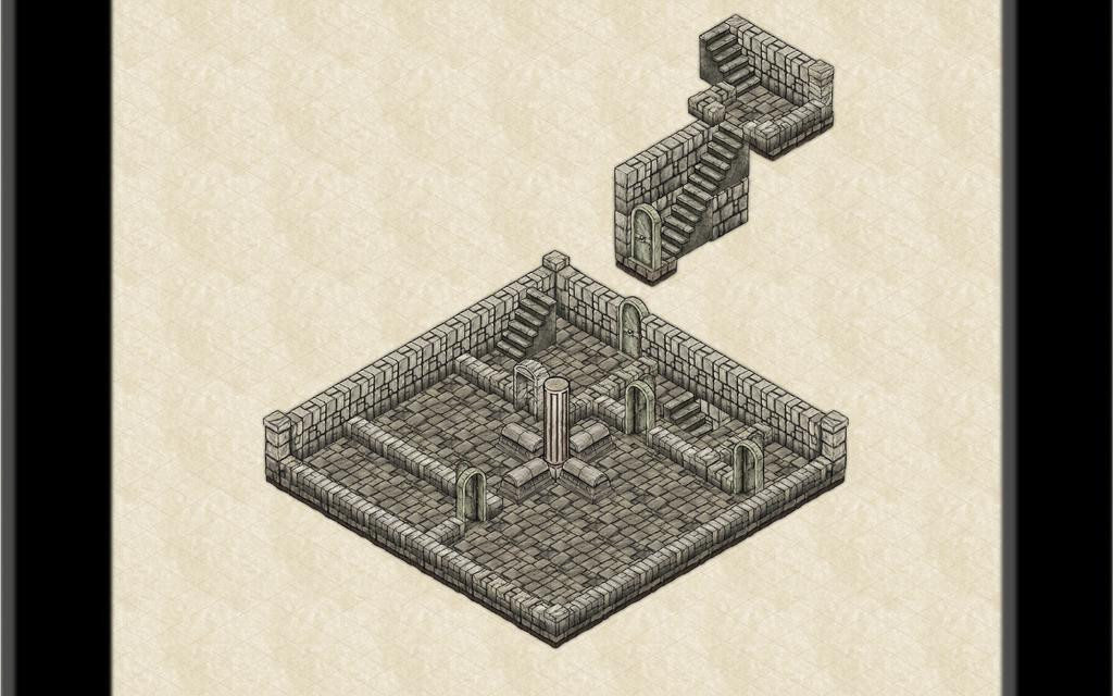
Several problems came up very quickly. The stairs can be shown only in the two orientations used here, thus can't be used to show a classic compressed staircase, such as you can find in many houses, because there isn't a "reversed" option. Then there was the difficulty of working out where the internal wall lines were in relation to the size of the map, and also, even using the 5-foot isometric snap-grid, getting them correctly aligned with one another. The doors proved even more tricky, as at least with the walls, there's a definite lower edge to work with; the doors though have a broader footplate, so the closed ones are slightly recessed into their frames and the walls. Looks nice, but a nightmare to align properly!
And then there was the descending staircase going below floor level... Numerous "Escher" moments ensued trying to click on all the symbols required, whose edges were NEVER where I thought they should be, to "Bring to Front" or "Send to Back". There can be essentially just the one SYMBOLS sheet for everything on these isometric drawings, so such ordering is essential. And then there was getting that wall behind the stairs slotted in, something I only realised was required after, finally, emplacing the stairs correctly... It is possible Naughty Words may have been said!
Let us draw a veil over such matters and move on another session or so, with the various Tower floors now sketched-in, just as a crude layout scheme:
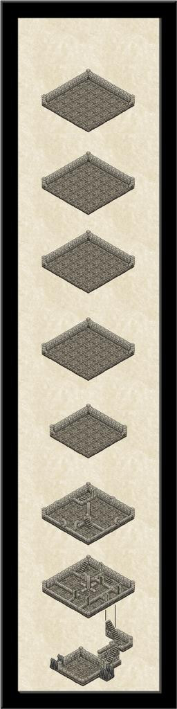
Copy & Paste works wonders sometimes, along with selecting and moving entire levels together, using the Ortho option. Thus the completed subterranean segment at last underlies the surface level one, the next level up is underway, along with the initial resizing of the level above that. The thin black vertical link-lines hopefully show how each level connects with the next.
Of course, some of the problems I encountered are because I'm trying to draw something the style wasn't designed to accommodate - a mostly above-ground tower structure. There are, for example, no windows, so I had to resize the open doorway arches to serve instead, and while they don't look too bad (even on an unblurred version, with a resolution that you can actually tell, unlike here on the Forum!), they're not ideal. Needs must, though, and indeed in much the same way as I'd had to resize the great central pillar and its magical mechanism cabinets on the ground level (repurposed sarcophagi). The pillar runs through to the Tower's top, and was originally to channel magical energies drawn from the air outside through the static windmill-like vanes there, down to the surface level and on into the cellar's summoning chamber.
Which is where we'll leave it for today. Plenty more to do still though!


-
Community Atlas: Constructing Errynor Map 40 - Faerie Land
While I know some folks that comment and contribute here like to present and view Work In Progress topics, I rarely map in a way that allows this, as I tend to simply change things as I'm going along and don't record what's been done or when. It also needs extra time and effort, which is something I rarely have available either. However, when I started the second of the 40 250 x 200 mile maps for "my" corner of Alarius, that did seem a rare opportunity to try to do a bit more in this line. So while not a WIP thread as such - because the map's already completed, and will be submitted for the Atlas shortly - it may be of interest to some to have an overview of how it got to be as it is.
When I started preparing for this whole Errynor project, one of the first things I did was to set up the grid for where the 250 x 200 mile maps were going to be on Shessar's Alarius map:
I then hand-drew onto squared paper details extracted from this map for each of the planned 40, including things like where the exact lines for the different background terrain fills lay on land, where the edge of the contour-colour fills were for the sea, and so forth. Although these wouldn't be so critical for the later mapping (the edges of the fills being softened in the map as shown above here means there will always be a degree of leeway in such things), they were important for some of the more detailed features I wanted to add, such as creatures which tend to be biome-specific.
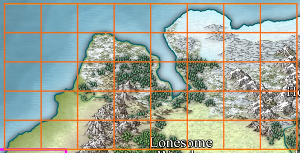
Zooming in to the Map 40 area (lowest right corner of the full gridded map above) showed what I'd be dealing with here:
The yellow line that's just peeping out from under the lowest outer orange line is for the southern limit of the Errynor mapping area (it also extends up the right-hand edge of Map 40, but is better hidden there), while the thinner white line extending south of the right-hand corner of Map 40 is because when this mapping began several years ago, the area east of Errynor had been reserved by another Atlas mapper. Ultimately, the person who was hoping to map that region had to drop out unfortunately, but Shessar subsequently stepped-in and completed part of it, although that no longer extends south to the southern edge of my Errynor area, as a comparison of where the major river (now named as the Faerie Run) lies in relation to the lowest corner of the illustrations above and below this paragraph. On the following extract from the bottom left corner of Shessar's "Alarius North Central" map, I've added a 250 x 200 mile orange rectangle for scale:
The left edge of this rectangular area immediately adjoins part of the right edge of my Map 40, and also part of Map 32 to Map 40's north.
Returning to Map 40, to the hand-drawn map of landforms and terrain features, I added randomly-rolled creatures and places using a series of tables based on ones I'd constructed decades ago, updated and amended here where that seemed necessary. The squared-paper maps had been designated so that every square would be five miles on a side, and each 5-mile square was allocated a maximum 10% chance of having something noteworthy in it at this mapping scale (variably reduced for anything less favourable than temperate surface land conditions). Of those features, about 17% - 1 in 6 - might be settlements of some sort, with a maximum 60% chance of being inhabited, or deserted/ruined otherwise, again partly condition-dependent.
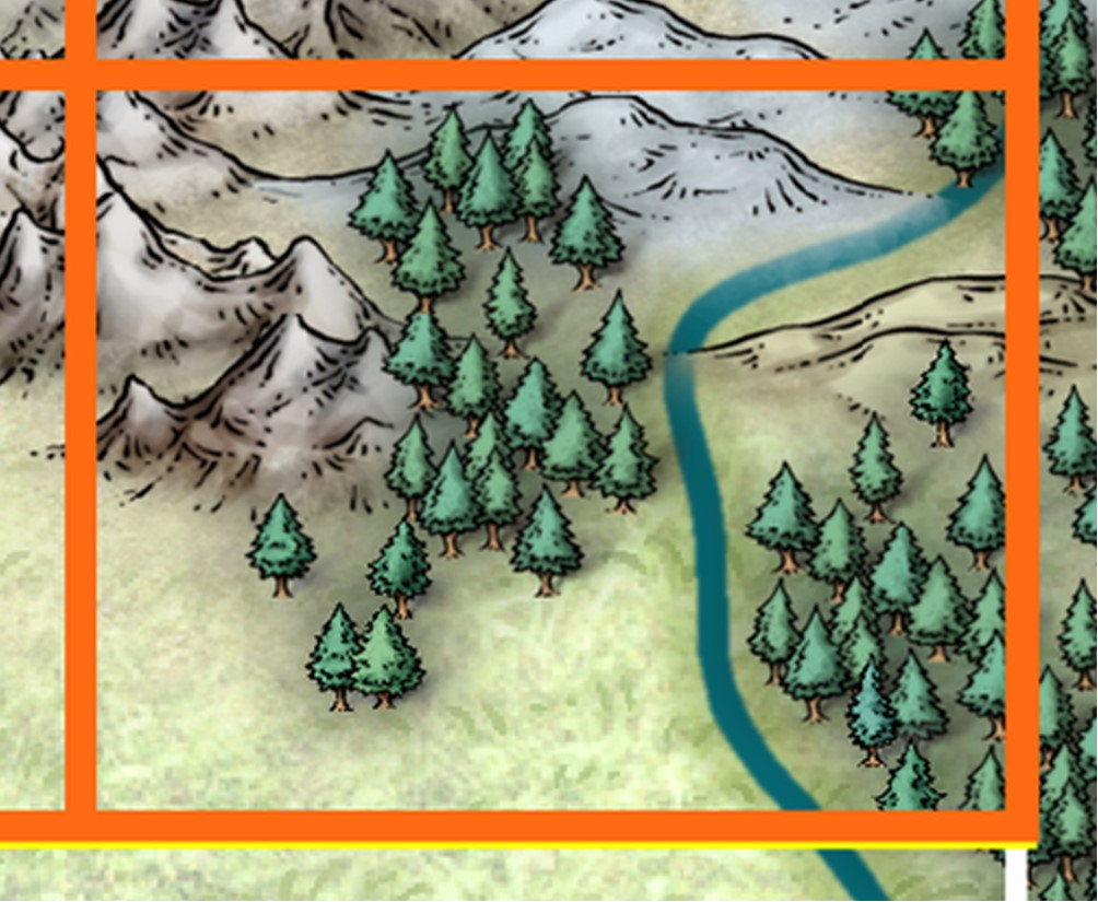
All of which got me to the point where I could also begin filling-in some of the lesser terrain features based on what had been rolled-up. Settlements need a significant water supply, as would some types of creature, which allowed new river lines to be sketched-in. Certain creatures also need a lair of some kind, and that meant smaller areas of cliffs, caves, trees, marshes and lakes could be added, all again based on random rolls determined by the creatures in question. Thus the map came to look like this:
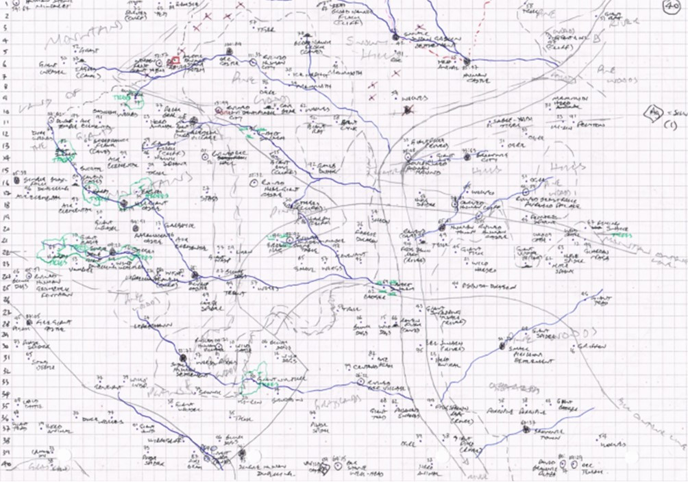
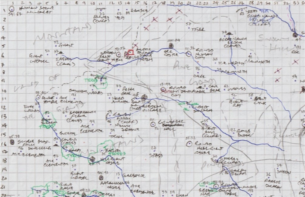
This isn't very clear at the size suitable for the Forum, and the scan I made of it has cut-off the column numbering along the top edge. This wasn't important for what I intended, as it was simply meant as the traceable background bitmap image for the CC3+ map. I can't re-scan it like this, as it's been further amended since, and indeed right into the creation of Map 40 in CC3+ changes were still being made, not all of which ended up on the hand-drawn version anyway! It is still possible though to see this is a "warts and all" sketch, with crossings-out, amendments and annotations. Even the original map isn't as clear as it might be now, and I can't remember which of the various lines represent which terrain type in places where the annotations have become too dense! Note too that the line of the map's only major river (that is, the one shown on the original Alarius map) hasn't been finalised here. It's still drawn at the scale it was, so is about ten miles wide, hence why the new tributaries end at its edge. As this also illustrates, the size of the paper means the edge of the mapped area is seven squares short of this image's right-hand edge.
Features were allocated one or two numbers as well as a written note of what each was, as I learnt early on the importance of recording these (they're the dice roll values) after making some mistakes in identifying which thing was in which terrain type, and thus what the random tables said it was meant to be... In the map's centre-top, that Yeti that became a Blood Hawk Flock with a cliff lair turned out to have been a Yeti after all, as you may be able to tell from this close-up of a later version of just the top left corner (now so you can see the top column numbers too):
If you can see some dots that don't have any annotations, or other faint markings, that's because I hand-drew all these maps on both sides of the paper, and occasionally that shows through weakly.
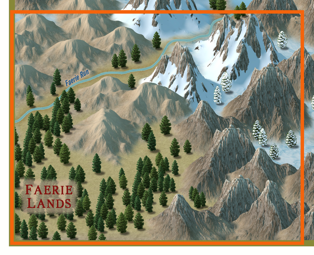
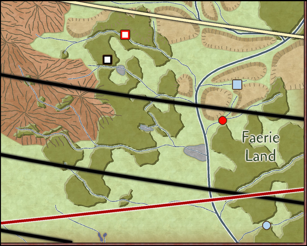
Selecting only the main features, such as the major settlements and ruins, as well as the new lesser watercourses and vegetation areas, was what let me build-up the final Errynor map, of which the Map 40 segment is shown below, here with its latitude lines and the southern limit for Nibirum's northern polar auroral zone (red arc). Only the cream-coloured latitude arc, for 55°N, features in the Atlas CC3+ Errynor map. The black arcs for each 1° were added in preparation for these individual 250 x 200 mile maps, and will feature there:
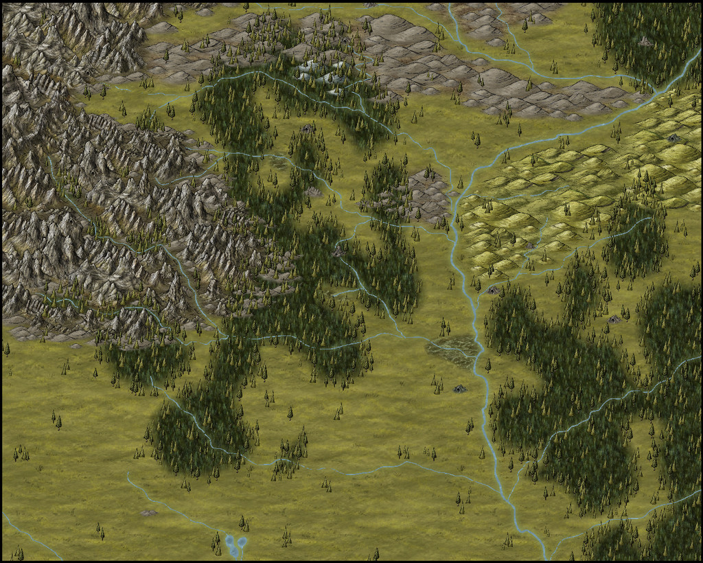
I'll present and discuss the final CC3+ map for the Atlas in more detail in a subsequent Forum topic. For now, merely a teaser view of the final Map 40's terrain (only) - no settlements, or creatures, or anything else. Yet!

-
[WIP] Community Atlas: Snakeden Swamp, Lizard Isle, Alarius - Dedicated to JimP
Sometimes, the Forum throws weird notices at you while you're doing other things. That can be because you've been sent a new message by someone, or somebody's just posted in one of your topics, or someone's added a new post to the topic you were typing your notes into, for instance. Here, I just posted the above, and suddenly it announced I had achieved the rank of "Cartographer".
Now, these labels are just for a bit of fun on the Forum here, of course. However, it seemed very apt that this should have happened by chance while I was adding to this topic, because our departed dear friend JimP was also of that rank. It just made stop, think and remember again for a moment. Which was also part of the purpose in my doing these maps in the way I am.

-
19 c. map - is there template I can use and where it is (modern? one of annals?)
It may help you decide how and what you'll need to draw by finding a real-world 19th century map that you like and think will work for what you're intending (suitable for the size and type of area you want to map, for instance). Then take a look at the thumbnail images for the various Annual issues that Loopysue created elsewhere on the Forum, to see if any of those match closely enough to what you're aiming for. Each thumbnail links to the correct issue on the main ProFantasy website, where there are different examples of the same style in use, which again should help you decide which might be better for what you want.

-
Community Atlas: Embra - Hilly Places
The first of the Hilly Places of Interest is a rocky mound by the curiously narrow River Clack, Palace Heights:
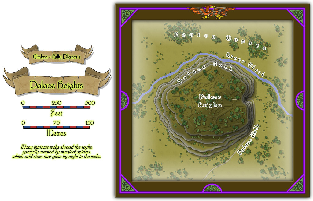
No real sign of a "Palace" as such, although that maze of low, grassy features all over the slightly domed hilltop hints that something may have been here once. This is one of those Places I'd had an idea or two about before the project was too far along, and parts of this map will recur in a subsequent one from the Constructed Places, where the Palace isn't just a series of grassed-over ruins. Faerie time-dilation effects can permit all sorts of weirdness, and in this case, both the hill with ruins, and the hill with a fully-functional Palace, can coexist simultaneously in Embra. The particular one to be found - perhaps even both - dependent on how the city is navigated.
The original concept came about loosely because the real-world city of Edinburgh, which was an early influence for Embra, has its own great castle-palace, set upon a rocky pinnacle in the city, although the two aren't closely comparable beyond that, chiefly because each of the Places for Embra being unconnected from any others, has to be presented on a more-or-less standalone map, whereas Edinburgh Castle's rocky platform continues down into the adjacent street area leading up to it, known as the Royal Mile.
![[Deleted User]](https://secure.gravatar.com/avatar/c75d9a245b74d9c59be0999ea81ca541/?default=https%3A%2F%2Fvanillicon.com%2F92add7f8c954488718110edc4896ad39_200.png&rating=g&size=200)

-
Dhakos, The City of Spires - Watabou Cities Annual
Well this is weird, as I've just dropped-by the Forum here following a lengthy discussion on one of my Discords with someone about the old Chaosium versions of the "Stormbringer" RPG, a few minutes ago!
Not sure if it'll help with your spires query, but I had to draw my own shadows of not dissimilar form for one of my Atlas maps a while back, the Thalassan Castle Ruins. The FCW might give you a further pointer or two, perhaps. Or perhaps not! Good luck, regardless 😁


-
WIP Goldenlilly Dungeons
As Sue suggested, something to help the bars look more vertical probably would be helpful.
Maybe think of reducing the intensity of the shadows overall, given they don't really work with the light sources in the dungeon.
Some of the shadows - for the buckets and smaller round table - are also perhaps too large for what they are. The buckets probably shouldn't be casting the same length of shadow as the rack and dissecting table, for instance.

-
[WIP] Community Atlas, 1,000 Maps Contest: Villages in The Whispering Wastes of Haddmark, Peredur
The eighth small settlement in this set is from Hex 1604, Brightlawn Hamlet:
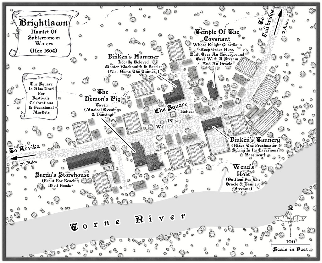
No especially fancy elements were required here, although as a major river shown on the Atlas map for this continent, the Torne needed to look somewhat more imposing than the others to feature so far, and I did feel it would be useful to include an outlet into it from the subterranean streams that had been randomly decided-upon as part of this hamlet's layout. The settlement is also relatively close to the edge of the Siljan Hills, so a few more of the style's contour lines were added than normal. I did trial one of the cliff-line symbols for what became the Wend's Hole stream outlet as well, but that just didn't look right, mostly because the better-shaped of the cliff options is intended as a promontory, with the cliffs on its outer side. Instead I simply hand-traced the line of that cliff piece, and drew the little cliff-line markers to make it look more as if this was a hollow than a clifftop, which in combination with the contours and a mild shadow effect (suitably masked in part) seemed to work well enough.
Everything else was much as has become normal for these village maps, with properties of varying sizes and types, scattered vegetation and a few fields. Interestingly, the random options here from the Shadowdark tables came up with an area with a pillory and a "Wanted" noticeboard that wasn't a market place, although it makes such an obvious feature in the settlement, I decided occasional markets could happen there too. I added a well, and a hut by the noticeboard, since it made sense to develop that other local notices might be pinned-up there, thinking of medieval European settlements and how things such as broadsheets were presented publicly. The oracle in the cave below the small temple here adds a further note of mystery to the place, which hopefully helps make it seem a bit more "real"!

-
[WIP] Atlas Contest: Village of Djayet (Gold Coast, west coast of Doriant)
Scalebars are fine in the Atlas.
You can change the font in any symbols like this in your map by making a new symbol with your preferred font in.
Select the symbol in Symbol Manager (in the Symbols drop-down menu), and Clone it, giving it a new name (this is very important, so you don't overwrite the original symbol).
Then, still in Symbol Manager, select your cloned symbol and click to Edit it. Draw your editing pane and then make whatever changes you wish - all the usual CC3+ tools are available to work on the symbol.
Once you're happy with the new version, click the cross box in the top right corner of the editing pane to dismiss it, and you'll get a terrifying message like this:
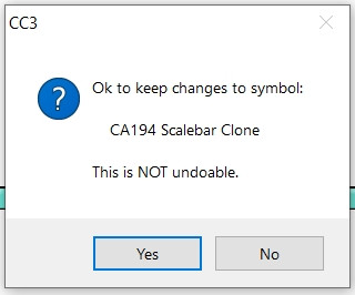
Despite the terror, click "Yes" - it's fine to do so with the cloned image.
Then your revised scalebar will be available to use in that map only.
-
Commercial use of maps
Yep, I think many of us have learnt far more than we wanted to about the murkiness of copyright and IP laws in different parts of the world in recent months, thanks to events elsewhere in the RPG world.
Bottom line is it's probably safer to create your own new maps from scratch, than try copying anything someone else has done, however varied, especially when you're intending to make money from doing so.

