


Wyvern
Wyvern
About
- Username
- Wyvern
- Joined
- Visits
- 3,303
- Last Active
- Roles
- Member
- Points
- 5,647
- Rank
- Cartographer
- Badges
- 24
Latest Images


-
Floor Tiles
I'd have thought cats would love Jenga towers. Might not be a "tower" for very long, but...😉🐱
-
WIP - Senan
Indeed, good luck with the surgery. As someone who also has manual dexterity problems, I can quite appreciate the problems. CC's been a definite boon in this regard.

-
Floor Tiles
@C.C. Charron commented: I never finished the map for Dread, played anyway. Everyone died.
Typical game of Dread then 😉!

-
Community Atlas: Map for the Duin Elisyr area, Doriant
@Don Anderson Jr. commented: For me personally the text looks to fuzzy. Can the glow be lowered so the text edges are sharper, or is that the aesthetic you are going for? (or did you compress the image a lot during conversion?)
I think it's just an issue with the resolution here on the Forum Don. The symbols also look pretty fuzzy to my eye right now on these shots. At a higher res on screen and in printout (at the level the map'll be available in its final version in my Gallery), it looks fine. I am also using a smaller size image than the maximum allowable here for these WIP shots to try to keep things a bit more manageable, as they're really just for general illustrative purposes. I did run a few tests to adjust the text glow early on, and this was certainly the better option from those at the "proper" resolution levels.
Back to the mapping, if with a shorter update today.
Adding the randomly-allocated features to the lower left quadrant meant dropping-in a couple of more substantial pieces of woodland, as already identified from the Duin Elisyr base map. That in turn meant thinking of adding some further smaller scraps of woods elsewhere, all of which quickly snowballed into adding place names for some of the main rivers, peaks and valleys, along with the first extra trails. There was also some tweaking of a few river lines, thinning some out, adjusting the courses of more, and suchlike. Plus amending the line of the pass road to better fit alongside the southern river out of it, now named as the Saskulaana. So it's all starting to look a bit more "lived-in", with just the upper left quarter to complete:
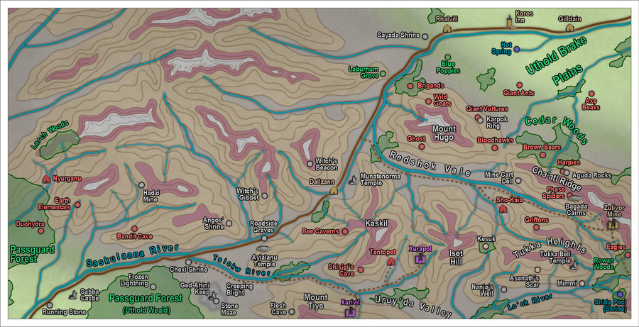
More tweaking of already-placed elements is likely, of course, and at some stage soon, I'll need to find somewhere to put the title, scale and compass pointer!

-
WIP: ICS Immaculate Radiance
Don't forget an alternate bridge to command the vessel if it's liable to see combat. Even if the primary bridge is buried deep, that's no guarantee it'll survive the first minutes of an encounter, as it's the classic place to aim for if your targeting is good enough.
Bridge location is heavily dependent on the tech too, as Don notes. Normal windows are useless for anything other than pretty views of whatever's close-by, for instance, so some tech for even "normal viewing" is essential to avoid endlessly wondering if that faint star's a faint star, a massive enemy vessel or a missile heading directly at you. Even massive craft become near-invisible dots at astonishingly tiny interplanetary distances after all!
Dalton, not sure what you're meaning by "texture for the hull that resembles the white complex details of a Star Wars ship", as I thought there were various bitmap options for the rectangular plate effects on imaginary craft like this in Cosmographer already. The Dundjinni Archives have more variants too, and Storyweaver Highspace, for instance. Maybe you're meaning some other kind of texture though? (I'm not very up on Star Wars tech, as I've long found it too unbelievable to be interesting.)
-
[WIP] Sea Elves Outpost
Yep, a mapper after my own heart - wanting to make maps complicated, with many different features that can be accessed only by turning layers on or off 😉😁!
Only point I would make is the undersea plants need direct sunlight (or a magical equivalent) to grow, and many tunnels and rooms seem to be entirely roofed-over. Since the water seems to be shallow enough around the island, you could add giant kelp forests in places there (which could help further disguise the undersea access tunnels), as well as other marine plants to help here. They really needn't be just close to the shoreline, as so long as the water's less than about 200 metres deep, there'll be enough sunlight for photosynthetic growth.

-
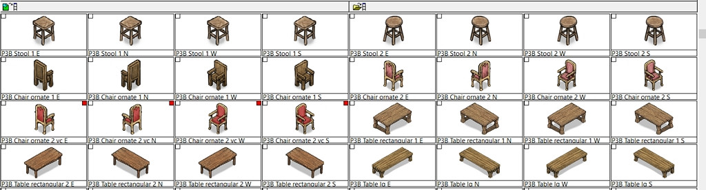
isometric throne symbols
It looks to me as if two of the Throne images have been omitted from the set with Temple of Bones Annual, simply judging from their name-labels and the fact the Chair symbol has all four options correctly.
If that can't be resolved, I found some ornate chairs under the Perspectives 3 Bitmap B options that might work (one is varicolor):
-
[WIP] Sea Elves Outpost
Hydrothermal and other undersea vents come in all shapes and sizes, much as they do on land. As I was working with the deep ocean floor, I wanted something like those relatively recently discovered with entire ecosystems, all with no reliance on sunlight. No plants, naturally, but a fascinating variety of creatures that congregate there. No reason you can't have them just as you've illustrated here, certainly!
-
Improving my rivers
Note though that the edit function doesn't work on smooth entities, only straight or fractal ones, and you must have used a drawing tool to create the original entity as well, as far as I'm aware.
-
[WIP] - King's Shire - critique sought.
@Reddog remarked: I have to be honest, despite reading various threads about Layers and sheets, I don't see the need at all for layers, so have paid zero attention to them...
Like many things in CC3+, Layers can be powerful friends once you understand what they can do for you. Aside from the unique feature of being able to freeze and unfreeze things on a layer (something you can't do on sheets) - very helpful when trying to select something as long as it's on a different layer, for instance - as Don mentioned, you can easily hide or show entire fresh versions of your map using only layers. You can even toggle them by writing a little macro command, so as to do that with one click! Plus you can hide or show entire rafts of terrain or symbols, so long as you make sure they're on the correct layer. Like the GAME MASTER ONLY layer for hiding all kinds secrets the players shouldn't see (yet)!
Must admit, I've sometimes wished there was a way to group layers together, just as you can group sheets onto layers, so you could turn off or on an entire set of different layers at once. That's probably just me though 😁!


