

[WIP] Community Atlas, 1,000 Maps Contest: Villages in The Whispering Wastes of Haddmark, Peredur
 Wyvern
🖼️ 293 images Cartographer
Wyvern
🖼️ 293 images Cartographer
Delayed for a clutch of reasons during the last couple of months, I have, off-camera, been continuing with my sort-of Dungeon24 project for the Nibirum Atlas, drawing small dungeon maps, and, where necessary, the area maps to place them in. Progress has though been a lot slower than I'd hoped of late. Plus, as I was finalising the accompanying texts for the latest pair of maps, Remy Monsen announced the 1,000 Maps Competition for the Community Atlas, which has complicated matters further. We'll get to that shortly (although if you've seen my notes in the main Competition topic, you'll have some idea already).
As I'd enjoyed developing the black and white style reminiscent of that used in various of the Shadowdark RPG supplementary materials last time, with the OSR Dungeon style from Annual 97, I decided I wanted to continue with that for the other three maps created from designs rolled-up using the Explorer set of Inkwell Ideas Dungeonmorph Dice. As it's turned out, this has also become a pleasing way to help celebrate the Shadowdark RPG's winning of no less than four prestigious Gold Awards at this year's Ennies, announced at GenCon on August 2nd (for Best Layout & Design, Best Rules, Best Game and Product of the Year)!
Back to the dungeon map and where it was to go. The random choice for its location was to be Peredur, as last time, now though in the southern part of that island continent, in Haddmark:
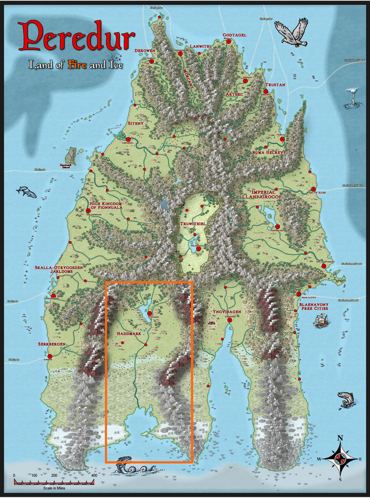
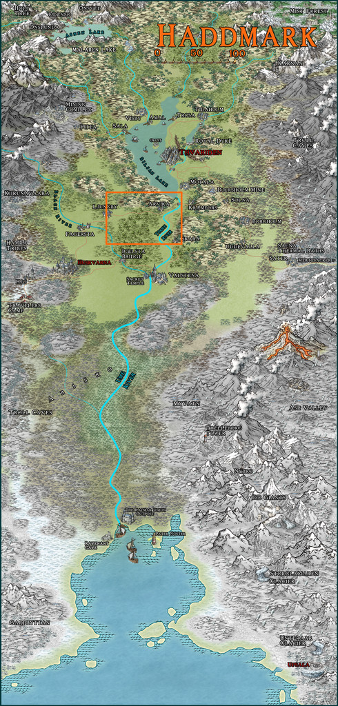
I soon discovered that this region had been less heavily mapped than others on Peredur, and as none of the regional maps really fitted with what I'd been thinking of for this dungeon, came to the conclusion I'd need to draw an area map as well. Of course, I wanted a black and white option for that too, to try to emulate the style of hex-maps used for similar areas in the Shadowdark supplements. These have a very specific size, using 6-mile horizontal hexes, with 17 columns west-east, by alternating 10 and 11 rows north-south. Typically, I had to expand my map by one column to make sure I collected all the places in the area I eventually selected (after quite some internal debate), a minor amendment. The area I went with doesn't have a name-label, so, and partly for how I'd already started developing the dungeon map, it became the Whispering Wastes, here:
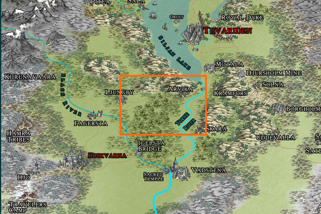
Even so, it was a bit of a squeeze! This was the base map, with a suitable hexgrid superimposed that I used to draw the final map, with the place-name labels hidden for clarity:
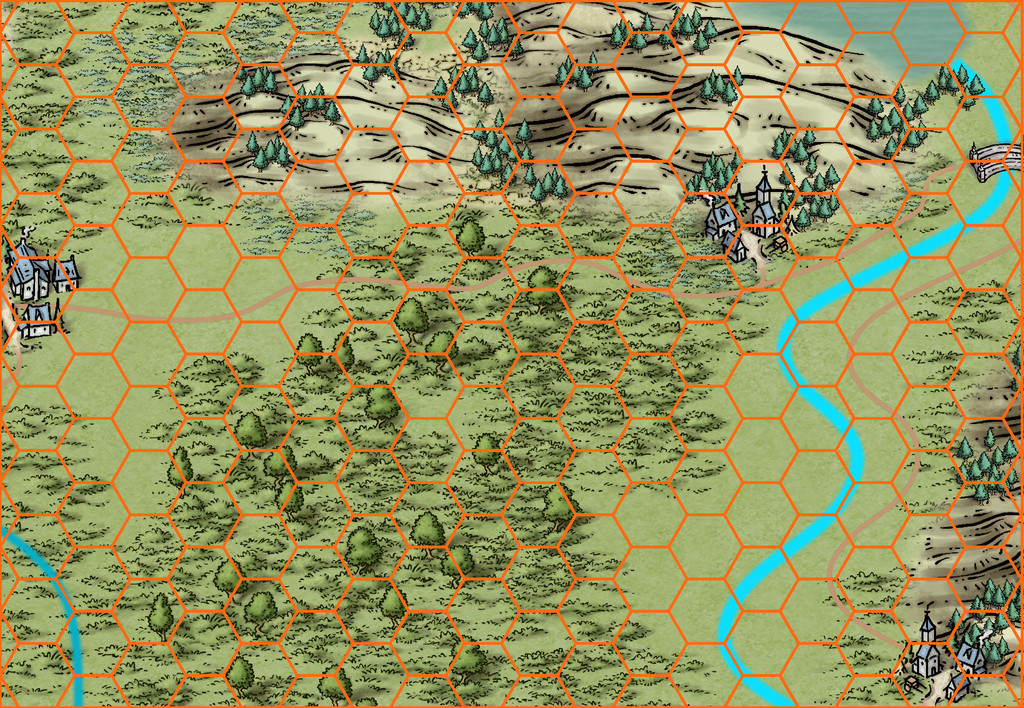
Then, as normal, I randomly rolled-up a variety of overland map features, in this case using tables, with occasional amendments or adaptations, found in the main Shadowdark rules (which have a specific hex-map design system). Indeed, aspects of those tables would allow the creation of more detail for many of the places. While time-consuming to do in full, I did give serious consideration to this for a while, although as luck had it, the dice came up with rather more hexes with features than the average for this map anyway - 41 instead of 31 - which acted as a deterrent.
Some places were obviously decided already, with the three small settlements and one bridge symbol (which I decided should be another settlement too), although randomness being what it is, only one of those coincided with the hex-feature rolls, so a few adjustments had to be made. I did though retain or adapt those "moved" features into the settlement hexes as well. After which, it was time for the CC3+ mapping!
I opted for the Annual 121 Black & White Fantasy overland style as the basis, since it has a useful range of symbol options, which was then labelled-up mostly using the standard Windows Arial font, except for the title, which continued the use of Primitive, from the 2015 Annual, as previously. And this is how it finished:
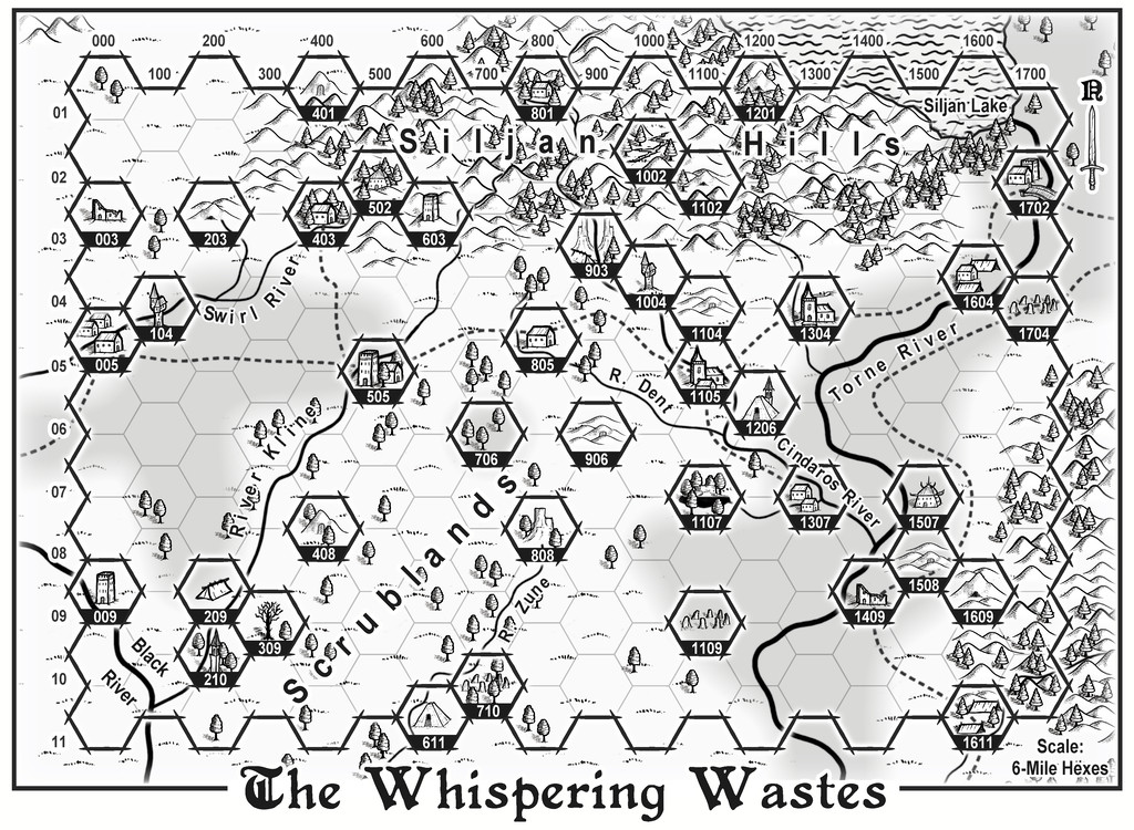
The highlighted hex-map border and individual number-labelled hexes follow the style set by the Shadowdark supplements, though I stuck with the Annual's normal road, water and river appearances for ease here. On-map labels are typically kept to a minimum on the Shadowdark maps I was mimicking, so the place-names for the one-hex features are all to be found in the accompanying PDF and text map notes once in the Atlas only. I also decided to extend the mapped region a little outside the hex-mapped zone, as while ordinarily those outer hex-lines would form the border, that felt a little too edge-of-the-world to me in this case, as well as creating problems for where to add the main title, compass pointer and scaling note.
Overall, I was pleased with how this turned-out, although I have a fondness for hex-maps anyway, so am likely biased!


Comments
Having thus generated the surrounding wilder lands, it was then time to construct the random, geomorphic-dungeon-designed map, as noted earlier, using the OSR Dungeon style from the 2015 Annual, in the manner established for my immediately prior map, again mirroring that used in the Shadowdark supplements. Since the Inkwell Explorer dice are one of the sets for which no written descriptions are available, I'd had to work up some ideas about the content well in advance, so seeds for some could be planted in the regional Whispering Wastes map. One of the random map designs for this layout was a fairly obvious temple structure, albeit with a curiously crystalline-looking central focus:
Having tried a few random rolls on the main Shadowdark tables, I came up with a cult that spoke only in whispers (which of course ultimately developed into the area's name), but nothing that seemed to match the temple's crystal focus. So I turned instead, and rather by-chance, to a free PDF Shadowdark supplement, created by the online Discord community earlier this year, which allows the design of slightly weird mega-dungeons randomly, on-the-fly. This is called "Shadowdome: Thunderdark" (SD:TD), and was used to create a random mega-dungeon, run through by two teams of players in direct competition, at Gary Con 16 in Lake Geneva, Wisconsin, USA, in March 2024.
I began with a few random rolls from tables in SD:TD, and stumbled onto several items with a crystalline theme that way. Some quick adaptations to extract other related features, more random rolls and a few deliberate choices, and suddenly the layout became The Crystal Cathedral of the Whispering Wastes, or "Crystal Cathedral" for short:
This was located, hidden away and hard to find, in Lightning Ravine, Hex 1002, with the Outer Doors opening onto a ledge partway down one of the side-canyons in said Ravine. It was rather fun to watch the whole coming together from what was provided by SD:TD, with some expansions and a little adaptation in places.
Ultimately, the process provided a gigantic creature, "The Shimmering", that was living in the crystal, and which had descended from the stars long ago, sinking into the earth and creating a protective crystalline casing for itself. It had set-up a cult of humanoids (The Shimmering Cult) to provide living creatures it can feed upon, turning them into fresh parts of the crystalline features scattered throughout this little complex, with a view to eventually having sufficient power and energy to return to the cosmos. (Freely acknowledging here influence from Lovecraft's "Colour Out of Space", and Nigel Kneale's "Quatermass 2", where even the cult acolytes receive a small "mark".) The cultists become transformed into parts of the crystalline structures eventually, gaining extra powers and abilities along the way. Plus parts of the cult can be found in other places in the Whispering Wastes, as the notes for that map, and this one will suggest. Cultists who are always on the lookout for lone travellers and others who seem unlikely to be missed...
Ordinarily, that would have been that, submission ready for the Atlas, and I'd have been moving on to the next small dungeon map in the series, intended for somewhere in the Feralwood Forest of Alarius. However, while I was finalising the notes for both these maps, Remy Monsen dropped-in the 1,000 Atlas Maps Competition. As noted in my first posting here, the Shadowdark hex-mapping system allows the creation of individual sites as well, including settlements, of which there are ten on the hex map, all village or hamlet sized. As I'd already done the basic layout designs for these in preparing the map notes anyway, I decided to try mapping all ten. Whether they'll all be finished before the contest ends is, of course, another matter. I will complete them, if other things allow, regardless of that though.
First village is to come next - Ljungby (Hex 005)!
Hex 005, Ljungby Village. There is no established pattern for settlement maps in the official Shadowdark supplements as yet. Individual buildings and small groups of structures tend to be shown on maps identical to those used for subterranean areas, without illustrating the broader regions beyond them. Naturally though, in selecting something suitable for the Atlas, I was going to stick with a black-and-white style, and selected the Annual 100 Black & White Towns option as suitable for all these smaller settlements.
The Shadowdark main rules do provide random systems for generating settlements and places of interest therein however, including the general layout for roads and districts, which is what I used for all the settlements here, although because I'd already mapped the surrounding region, some adjustments and additions were needed. These systems don't provide details on population size or the number of non-interesting buildings, so for those, I turned to an old standby, my trusty, if slightly worn, "Village Book 1" from Judges Guild back in 1978, as this has mechanics to generate numbers of shops, etc., based on a randomly-rolled population size. I simply back-calculated a rough population size based on the points of interest already chosen, which allowed me to estimate a number of additional properties for each place.
I ran into a few difficulties with the chosen mapping style, as the Grass and Road Dirt bitmap fills come out very weak and faint (the Road Dirt one especially), and are scarcely visible on an image of the map, despite experiments in adjusting the settings. The alternative road tools use the Road Stone fill, which is somewhat harsh. As I wanted the roads to look more like tracks here, I compromised on something that could be seen on the final image OK, if still looking a bit too "stony", by adding a Transparency effect to fade the lines down, without using the original Edge Fade, Inner effect, as that seemed to be part of the problem making the Road Dirt fill effectively invisible.
Symbols for the buildings needed tweaking to get them to reasonable sizes (the standard size for some is fine for sheds and similar, but a bit too small for houses), and the typical problem with a number of the "City" styles cropped up, in that houses drawn using the drawing tool stand out far better on the map than those from the symbol catalogue. I simply drew the buildings that needed highlighting with the drawing tool, saving the symbols for everything else. Chimneys were added by-hand, helping to indicate occupied properties (sheds and barns were left without). The area is about 69 degrees South latitude after all, so no chimneys was never an option!
This style uses the AquilineTwo font as standard. However, I found this wasn't clear enough to properly read the labels, so switched to Primitive in all cases here, which meant amending two of the symbols as well, the scalebar and the compass indicator, to switch fonts. With luck, this all should mean the subsequent maps are a little easier to achieve.
And so to Ljungby itself:
One advantage with using Transparency on the road fills, is it makes the ford on the Swirl River look more "ford-like". I also chose to add the series of small plots in the lower right corner as the start of the nearer farmlands, and to represent small-holdings used by the villagers. There are a few sheds and barns scattered about there as well. I found adding sheds nearer the village proper started to make it feel too cluttered, with the scatter of trees and shrubs. Adding some sketchy contour line symbols north of the river helped indicate the land was rising that way, for all these need to be placed as free from other map features as possible, or they quickly become lost - hence why there isn't another south of the river. The eye's natural tendency to fill-in gaps helps the illusion here.
The other significant additions beyond what randomness had provided included the mill, with the miller promoted also to be village mayor. There's a dodgy bakery (which rumour has it may be the source of the rat problems north of the river...), so I felt a mill would be useful as well. The Market Place was a bit too blank, so it received a Toll Booth for collecting tolls from the market traders, and a well for arriving draught animals.
Only nine more to go!
Map The Second is...
Hex 403, Bruga's Hold:
A logging hamlet on the upper Swirl River, among the woods of the southwestern Siljan Hills, this is a rather isolated, frontier-style settlement, with trails leading-off to logging camps, or former ones (the trails southeast of the river crossing were where much of the timber for the settlement originated, for instance). Markets here aren't common, but the open space is handy for storing piles of fresh timber prior to sending it off down-river, or overland by trail southwards. The self-styled Queen's tough, if not as young as she was, and her extended family keeps most things more-or-less in-check here, though her nieces at The Corner Daughters have a tendency to accuse those they dislike of theft, something that works best with outsiders. The grandiose apothecary's shop-name was a random choice (it does look outwardly like a small temple), which seemed too apt to waste - see the notes above on the Crystal Cathedral - while "Merry Wares" became something of a running joke, as it cropped up randomly twice more in different settlements in this set for quite different places. I retained that too, as GMs can decide if it's at all significant.
On the original map, I started out with the woods rather denser than they are now. That looked much too dominant, and would have been unrealistic so near the settlement, so, much like the original loggers here, I had to thin them out somewhat. The mapping style makes use of both tree and bush symbols, and a bitmap tree fill drawing tool, which in combination for the densest areas here help give the woods a particularly 3D feel, although the symbols have to be applied judiciously to better hide the edges of the bitmap-fill segments. Of course, I had to delete and redraw all the first areas of the fill, as they were far too large, and it took a little experimenting to get the sizes right after that, in combination with the individual scatter of trees and bushes. Luckily, I had a fair idea of how best to achieve all this, as - although it was using a somewhat different style, and in colour - I have done quite a bit of woodland mapping for the Atlas before, for those who remember the extensive mapping series for the Faerie City of Embra - like the Wooded Places maps.
And so to the third map, Hex 505, Ivan's Keep:
Subject to frequent attacks by bands of Goblins and Kobolds, this had to be a defended settlement, and I thought it might be fun to use what is actually the symbol of a short stretch of straight wooden town wall, to create a neatly rounded palisade! It wasn't actually that difficult, after setting up a guideline oval to work with, ensuring the village properties stayed within that boundary, and then fitting the wall afterwards. The shortness of the wall symbol meant it actually worked rather well in this manner. As to why it's so neatly symmetrical (if not entirely to the low hill the place is built on), there is an explanation in the accompanying notes.
While less intentional, the mix of shadows and road textures does help make the palisaded settlement a very definite focal point for the whole drawing. Plus the fact the village wasn't always where it is now meant a couple of the ruin symbols that come with this mapping style package could be employed to hint at that. Most were cleared away when the Fence was being constructed, to help build the newer properties in the settlement as it now is, of course.
Three Inns for a small settlement sounds as if all the locals must be alcoholics - a way of dealing with the stress of continual goblin attacks i guess.
I don't know about that, Port Royal c.1600, more of a town than village, had 23 taverns for about ~5000 population.
Yes, but three taverns for such a small village? Mind you, Australia had towns like Port Vernon as well during the Gold Rush days. But it takes something like that with a large itinerant population to justify more than 1 pub per 50 people. And the example you gave is over 200 people per pub. ANd this settlement look like a population of no more than 2-300. Just sayin'
Well, historically, an Inn provides accommodation, it didn't have to double as a tavern. So two Inns and a Tavern doesn't have to mean 3 drinking places.
Since the local populace doesn't really need an Inn, they have their homes, two Inns may also indicate the place gets lots of travelers spending the night. and who likes to have a drink when finally not spending the night in a campsite.
Size of each place is also a factor, a small place may only fit 20-30 people, or even less, and if they serve as meeting place for the populace in the evenings, even 3 places isn't necessarily that extravagant for a population of say 300, as they would still only accommodate a small fraction of the populace, not including travelers passing by.
if they serve as meeting place for the populace in the evenings, even 3 places isn't necessarily that extravagant for a population of say 300
That's a good point. With my villages, I've tried to keep in mind how and where the locals would socialize. Taverns and inns are also good places to catch a performance of a wandering bard or troubadour, or a troupe of actors.
Also, a small village might still get a lot of travelers passing through if it's on an important trade route, or along a route for a pilgrimage to a holy shrine. Or the last stop for adventurers trying their luck searching for treasure in the ruins of an ancient temple (or their first stop on the way home). My village has a winery, and I figured that merchants buying wine at the winery to resell in other towns and cities would want a place to spend the night before heading back with with their casks of wine.
Still disagree that there would be three Inns in a very small village. Unless the village was so much bigger in the past, or there are many passing travellers. Otherwise, the landlords would go broke.
I agree with Remy. I think we have different cultural views in play here. In the UK you can have several pubs on the same street, even today.
Just wait to you get to my city of San Francisco. I’ve read that we have more liquor licenses per capita than any city in the U.S. Last time I counted, my neighborhood alone had 17 bars in a four-block radius! I will have to find out what our number of residents per bar works out to be.
Yes, I expect something like 1 per 200 at the most. But that also doesn't allow for concentration of bars in an area - you have to take the whole town into account.
For example, the town strip here contains about 15 bars and pubs - but the population of the suburb is low - However, it serves a wider area where there are few or no pubs/bars. So in the end, Geraldton has a bar etc ratio of about 1 in 500 for a population of 40,000. And in Australia, we are NOT short of pubs, believe me. If you include accommodation, then the ratio gets smaller - however, Geraldton is a tourist town and this accommodation actually caters to many itinerants/tourists.
If the small village doesn't have a lot of itinerants, then there would not be much need for accommodation, certainly not 3 Inns which unlike taverns, have accommodation as part of their existence.
And Wyvern's village sur doesn't sound like a town that gets many visitors. It seems a town more under siege.
Place four is from Hex 805, Toresk Village:
A somewhat more conventional, "open", layout for the next village in this group compared with last time's Ivan's Keep, if with more potentially untoward locations this time, including an overt reference to The Shimmering Cult, to add a little more linkage between features across the maps in this Haddmark mapping extravaganza. Those who read through last time's PDF notes here will have learnt the Druids from Hex 611 had a hand in creating the defences at Ivan's Keep (and may be responsible for the Goblin attacks on the place too, while The Shimmering Cult may be behind the Kobold attacks there...). Here, no similar problems, just a variety of dubious or curious goings-on. The map notes, as usual, have a little more detail.
Even so, I wanted the layout to be a bit odd, since the random rolls in the Shadowdark tables had come up with a Chaotic nature for the settlement (for those unfamiliar, most things in this RPG can be assigned an alignment - Law, Neutral or Chaos - as a keyword for GMs to apply as they choose to provide variant atmospheres for different places). So the village began nearer the river as a planned layout, but as more people came here, it spread more haphazardly eastwards, such that the older properties are now rather run-down and ill-favoured, despite also having a neater street pattern and fancy road-end walls.
Halfway point, or map five of the ten, if you prefer, is reached via Hex 1105, Osalin Village:
One interesting aspect for me as mapper with this sub-project was how readily the places each developed their own character, partly a result of their broader map setting, partly thanks to whatever features the Shadowdark random tables had come up with. In this case, there was the chance to map an unusually extensive area of burials, an aspect which truly defines the settlement, given that the area occupied by the dead is greater than that of the living village. Everything there was placed individually, to make sure things were never too neatly-ordered, although it's perhaps best not to peer too closely at what some of the repurposed symbols involved as the grave markers actually are! What's important at this map-view is the shape, texture and the shadows (or equivalent effects - there are some "Solid 10" shapes with variant Lighted Bevels in places, for instance). While time-consuming, it was rather satisfying to see the whole area growing in a more or less organic manner.
I'd already decided there might be hints of connections with a couple of the barrow-fields in hexes some way from the settlement on the Whispering Wastes area map, so adding a few more Solid 10 bevelled shapes for a few barrows closer-by seemed simply a natural adjunct. What was perhaps more surprising was the random tables provided by-chance an undertaker, properties hinting further at the ancientness, not to say weirdness, of the setting here, haunted warehouses and a little old temple suitable for hosting celebrations for the deceased (and anyone else at other times, of course). I've mentioned before, there are times when you start to wonder just how "random" these things really are! All I needed to add was a mill, a few contours and those barrow-shapes.
Onward now to the second half of the ten!
Map six - Hex 1304, Arvika:
Arvika was one of the three settlements in this area that were originally shown on the existing Atlas map. In the absence of any text notes for it there, I simply looked at what the symbol was - a hamlet. As luck had it, no random feature was selected during the creation of my Whispering Wastes regional map for the hex it was in, but there was something in an immediately adjoining one, a mysterious ravine partly filled with webs, where a legendary artifact was guarded by a nest of Ettercaps. So I simply moved the ravine into the hamlet's hex, combining both elements. The hexes are six miles across, north-south, after all, so there's room for a lot more than just a single feature in each one.
The setting for the place was to be in a river valley, the Silvertongue, and I randomly discovered instead of the fords, so popular elsewhere so far, the proximity to the uplands had clearly provided stone enough for a bridge here for once, and it also turned out to be notably ancient, something that, like the Stormy Cleft ravine, simply helped reinforce why this hamlet had ended up being shown on the Atlas's area map, while other, seemingly larger or similarly-sized, settlements in the Whispering Wastes had not appeared there. Mapping it was straightforward enough, with the contour symbols fitted-in to act as the entrance to the ravine, although I did add a few more fields than I'd initially thought to provide some further interest around the settlement itself, which also lessened the impact of the ravine on the whole drawing.
Hex 1307, Rularn: Instead of simply presenting the seventh map in this series briefly, as previously, it occurred to me in time to actually make some preparations for it, that this would also be a suitable point to illustrate how the maps in this set have been prepared. This is meant as a sort-of WIP topic, after all. And yes, this is a bit late to remember it!
As those who've followed some of my previous attempts at WIP topics here will know, I tend to work from hand-drawn sketches, scanned in and used as a base template for my CC3+ maps for the Atlas. These small settlement maps this time though have been done in a slightly different way, without a scanned-in bitmap to trace or adapt from.
That's in large part because of how the layouts for these villages and hamlets were arrived at, using the Shadowdark RPG random mapping systems. By rolling a few dice, and seeing where some lie in relation to one another on the tabletop once thrown, a basic settlement layout can be generated. I varied that system slightly, by drawing on other random tables in those rules to further detail some elements, and for the hamlet-sized places - such as Rularn - I reduced the options for how many features there could be in them.
This first stage generated the following information, including a sketch-idea for the map:
So there are two districts, on the north and south sides of the hamlet, with the keyword names "Low" and "Slums" having specific references in the rules for what tables to use to decide on the features in each. From these can be derived a number of points of interest, sometimes for the settlement as a whole. I've added notes based on the location already decided for Rularn from the Whispering Wastes overland map, and, based on the number of items in the settlement, a rough tally of houses for the whole place, generated using the old Judges Guild "Village 1" book, as noted back in the post about Ljungby Village above.
From this base, another rough sketch was prepared, using the Whispering Wastes drawing for the specific hex involved, to get an idea of how the various component parts might fit together:
Rather than using this as a template, it's really just a loose idea at this stage. The reason the stone circle and henge bank haven't been added yet is because I need to see what the layout looks like in the CC3+ map first, and can then determine where exactly those will lie. The Mill, a specific addition here beyond what the random rolls have identified, might not survive at all, or might be moved, or converted to a windmill instead, say, to comply better with the stone circle feature. The line of the Cindaros River in the sketch is likely too close to the main settlement for everything to fit inside a particularly circular surround presently.
Moving next to the CC3+ mapping, I decided from the beginning that all these small settlements were going to be placed on identically-sized maps, 800 by 650 feet in size, determined using the sizes the various settlement-sized maps were for the Faerie City of Embra, referred to in the Bruga's Hold post earlier in this topic. The settlement itself would always be the main focal-point for the drawing, which would leave parts of the outlying areas available for a variety of additions or enhancements, including notes and elements such as the title, scalebar and compass pointer.
The first things to do included adding a title, dropping in the river lines, and the main road that connects elsewhere, with a label for that too. I put these basic names in so early to remind myself which map I'm doing, aside from other things! This also means I remember to check things like river and road widths from any map intended to connect, however distantly, with the current one. Sometimes these might not be the same - rivers tend to widen downstream, for instance, and roads don't need to stay identically-sized along their lengths either. However, this sets things up, which can always be changed later. These WIP map illustrations are deliberately under-sized compared to Forum norms, to clarify they're really only indicators of what was going on, rather than cluttering the topic up with images larger than is really needed for that.
Ordinarily, I'd next add the highlighted buildings for shops, etc., as these are typically the larger properties, or the ones that better-define the settlement's overall layout, and other notable features such as any market place. Here though, everything has to be constrained by an outer henge bank and ring of standing stones, so I set up a new TEMPORARY Sheet and Layer, and drew in a template circle on those to show where it was meant to be (and after a bit of trial and error, it must be said):
With that prepared, the identified properties can be added:
Since this settlement is at the end of the road, and had already been suggested as rather run-down, that seemed the ideal chance to make use of a few of the ruined buildings in this style, one of which - as used - had the form suitable for a rectangular warehouse-like barn/shed. Thus that shape and size became the template for the drawn properties alongside it, apparently in a better state of repair. I've also brought in a copy of the water mill already featured elsewhere in this series, although as we can see, it's now on the lesser of the two rivers here, to keep it within the henge-ring.
Adding the rest of the houses, with a few ruined ones, fleshes-out the settlement, after which more smaller roads and paths to the doors can be added, together with some larger expanses of paved yards, by the mill and baker's, the inn and the warehouse sheds, including a few walls:
It may not be that obvious at this smaller resolution, but I've also added chimneys to various of the properties. After which, the henge can be added, and the temporary green circle hidden (not deleted for now, just in case!). Having already experimented with the Solid 10 bitmap fill and some lighted bevel effects for the barrow mounds in the Osalin map previously, I simply reused that again here, copying the effect over to a new HENGE sheet. Somewhat to my surprise, it looked fine without further tweaking, although the colouring overall was too close to the rivers, so I decided to add something by copying the henge polygons onto the LAND FEATURES sheet and then changing their fill style first to use the CA100 Grass texture (which was OK, but not ideal), and then to what had been problematical earlier in the sequence of villages, the Road Dirt fill, which this time gave enough texturing "under" the semi-transparent henge polygons to help the henge segments stand out as NOT rivers (or ribbon lakes)!
With the henge in place, now just the standing stones were needed, and a similar technique could be applied to create those, a simple polygon with a suitable lighted bevel effect, although I did also darken up the shadows to help them stand out more, as at this scale they needed to be small. I opted for the bitmap Solid 30 fill style for them, again to give them better definition. Although at this reduced size, they appear as little more than dots, this view shows the northern half of the ring completed:
After which things started to move on apace, completing the standing stones' ring, then adding some labels, and starting to fill-in the gaps, with a few more changes. This shows a typical partway-through shot of the process. The Mill label has been moved to add some small fields and other vegetation as well.
From here, things tend to progress more organically, as fresh ideas surface along the way for how to make the place feel more "alive".
Followed by the rest of the labels, as the final map (now at its full Forum resolution):
One further minor tweak was made to the shadows on the standing stones, to darken them up more, and help them stand out better against the vegetation, with a new scroll and a further note or two on the nature of the settlement.
And suddenly, there are only three more settlements to go!
The eighth small settlement in this set is from Hex 1604, Brightlawn Hamlet:
No especially fancy elements were required here, although as a major river shown on the Atlas map for this continent, the Torne needed to look somewhat more imposing than the others to feature so far, and I did feel it would be useful to include an outlet into it from the subterranean streams that had been randomly decided-upon as part of this hamlet's layout. The settlement is also relatively close to the edge of the Siljan Hills, so a few more of the style's contour lines were added than normal. I did trial one of the cliff-line symbols for what became the Wend's Hole stream outlet as well, but that just didn't look right, mostly because the better-shaped of the cliff options is intended as a promontory, with the cliffs on its outer side. Instead I simply hand-traced the line of that cliff piece, and drew the little cliff-line markers to make it look more as if this was a hollow than a clifftop, which in combination with the contours and a mild shadow effect (suitably masked in part) seemed to work well enough.
Everything else was much as has become normal for these village maps, with properties of varying sizes and types, scattered vegetation and a few fields. Interestingly, the random options here from the Shadowdark tables came up with an area with a pillory and a "Wanted" noticeboard that wasn't a market place, although it makes such an obvious feature in the settlement, I decided occasional markets could happen there too. I added a well, and a hut by the noticeboard, since it made sense to develop that other local notices might be pinned-up there, thinking of medieval European settlements and how things such as broadsheets were presented publicly. The oracle in the cave below the small temple here adds a further note of mystery to the place, which hopefully helps make it seem a bit more "real"!
TL;DR
@Wyvern This is f'ing amazing! Well. Bloody. Done. You truly deserve your Master Mapper status.
In the Dungeon map, does the stippling fill come with the style (OSR Dungeons right?), or did you make it yourself? Regardless, it looks great.
I am in awe.
Wow! Super cool and useful tread!
Thanks very much folks!
@jmabbott asked: In the Dungeon map, does the stippling fill come with the style (OSR Dungeons right?), or did you make it yourself?
I explained how I'd arrived at this in the first post here earlier, and also why I'd opted to draw it this way (which is also why I've been sticking with a B&W style for all these maps too).
The essential points though, extracted from that linked topic, are that the style is the OSR Dungeon one from Annual 97, and that: The dot-shaded look was achieved first by laying down a base smooth polygon using the "Stones" fill texture, and then adding random selections from the two "Gravel" symbols over that on a separate sheet, all placed by hand, which allowed variable densities of such shading nearer the outer wall lines, and within the design, where rock pillars had been left in the Mirror Maze section particularly. The Stones texture had to be rescaled in the drawing to better fit the size of the Gravel symbol dots, which was pretty straightforward, and the whole does give quite a nice hand-drawn-like look to the shading.
Naturally, all I did here was to repeat that for this map. This time, I did get to play around with some of those textures for a genuine bit of the outside, as well as some plants, on the ledge to reach the front doors, however.
The penultimate map in this series of ten is from Hex 1611, Skara Hamlet:
Last of the three settlements marked on the Haddmark regional map for the area that is now the Whispering Wastes, this was in another hex that missed out on being randomly selected as holding a feature of interest, so one in its immediate neighbour to the northeast was simply swapped-in, which is how we have PlikPlok Cavern as a notable element on this map, or rather the entrance to it. Beyond that, looking at the general area map, it seemed likely this settlement would form a focal point for the surrounding farming and logging districts, given the western fringes of the Skara Bray hills, in whose southwestern tip Skara is located, have denser woodlands shown on them, along with the hills themselves, and the relatively nearby major Torne River. It also felt plausible that such places would be quite scattered, so the settlement itself was allowed to spread out here too, helping make it seem more important than the number of buildings alone might suggest.
While constructing the map, and having the overall close-by region in mind, I decided to add more walled, paved yards here than in other places, since the proximity of the upland surroundings - hinted-at by use of the contour and cliff symbols - suggested a more readily-available source of building stone for Skara. In-keeping with its somewhat lowly status though, the wall-lines aren't always especially straight. Nearer the centre, The Field and The Green ended up as open spaces almost by accident, as while I wanted to add some denser woodlands around the periphery, I didn't want those to become too dominant. Plus The Blade & Razors needed an outdoor space to expand its events into, and the significance of Skara to the surrounding areas meant some kind of open space for occasional markets - even though no specific market place was randomly assigned to it - seemed a natural addition as well. As mentioned before, sometimes these things just happen almost by themselves. Meanwhile the random option for a chirurgeon was amended to become also a vet, given the significance of livestock hereabouts.
Final map now approaches!
Hex 1702, Fairbridge Village:
Last of the ten Whispering Wastes villages and hamlets, Fairbridge appeared on the original Haddmark regional map only as a bridge, though it was an obvious feature to add a settlement to, if only to ensure the bridge's upkeep - hence the Toll House, an addition beyond the random options the Shadowdark tables provided, as indeed was the Mill, this time with a smaller stream cut from the main river channel to be a more controllable water source. River crossing points can be tricky places, as the ground needs to be quite low-lying to provide access, which in turn can be muddy and difficult, although here, I opted to have some marshes, largely because one of the random provisions was some sort of inimical creatures, and Will-O'-Wisps came up in that process. Naturally, nobody really likes using the Mill, because it's in the marshy land too, for all it is essential.
Those marshes also decided me against adding fields nearby this time. So many travellers have to use the bridge, essential supplies of food likely aren't going to be a great problem here, albeit the place is fairly run-down too, with many folk simply passing through. It is something of a gateway to the Whispering Wastes and the settlements beyond it to the west and south, from the more heavily-populated areas east and north from here by the great Siljan Lake.
Having completed this group of maps, it has again reinforced that it can be helpful to map places in a similar region in the same style for consistency, like this small settlement ten. It also makes things easier as the maps continue - and thus quicker - thanks to familiarity with the mapping style. The first map is always slower, while getting used to things, knowing what works and what doesn't. After that, things speed-up, and it becomes easier to try mapping new elements. The marshes here were my final challenge, as there isn't a marsh symbol or fill in this style, so I reused the rescaled "Trees" fill instead, simply because it looks sufficiently different to everything else. To make sure everyone's clear though, I also added some labels and small water features.
Onward now, as mentioned a while ago, to somewhere in Feralwood Forest, Alarius, for a suitable spot to site my next small dungeon map. It's going to be wild 😉!