MatthewBertram
MatthewBertram
About
- Username
- MatthewBertram
- Joined
- Visits
- 228
- Last Active
- Roles
- Member
- Points
- 83
- Rank
- Traveler
- Badges
- 1
Latest Images

Reactions
-
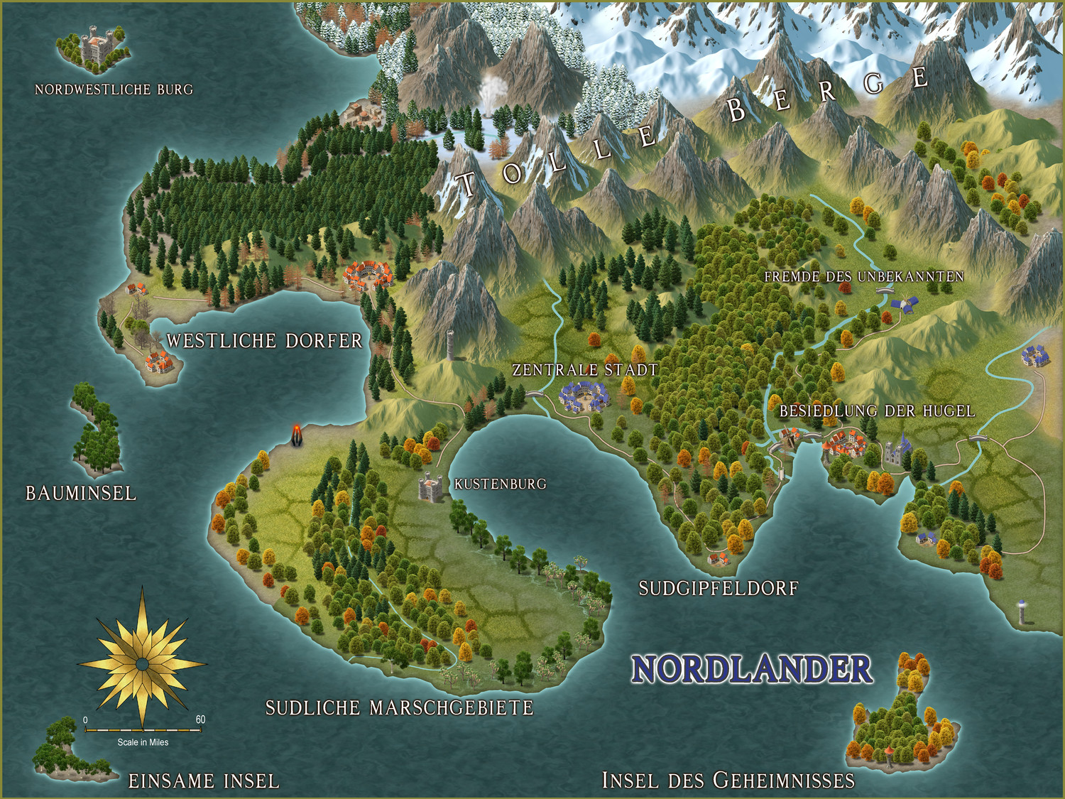
My 3rd map, using the Spectrum Overland style
Using the brilliant Live Mapping tutorial courtesy of @Ralf , I created my 3rd map Nordlander in CC3+. This one was a lot of fun! I thoroughly enjoyed the forests and adding the trees. I may have went a bit overboard naming everything (this time in German!) but I think that this is the one so far that I'm most happy with.
Quick question for all of you professionals though, is there a way to alternate simply by left-click between say a deciduous tree, a dead pine, and a pine? I love using the variations of each tree but I'd love to simply go through the gamut of a selection of them as opposed to placing pine, then switching over to dead pine and placing that, and then going to deciduous, then doing the whole thing over again. Seems like there's gotta be an easier way. Am I missing something or is that not a feature?
Either way, I have LOVED doing everything here with CC3+! I thought this was going to be the most off-putting incredibly difficult (according to some people online) program ever but it's become extremely easy and I love all of this so much! Thank you to all of those who have helped me on my journey of cartography! :)
(Full res JPEG available on my gallery)


 and 2 others.
 -
Look ma, no tutorial!
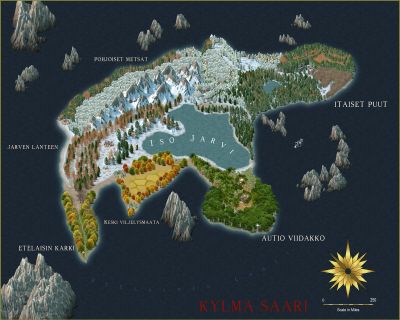
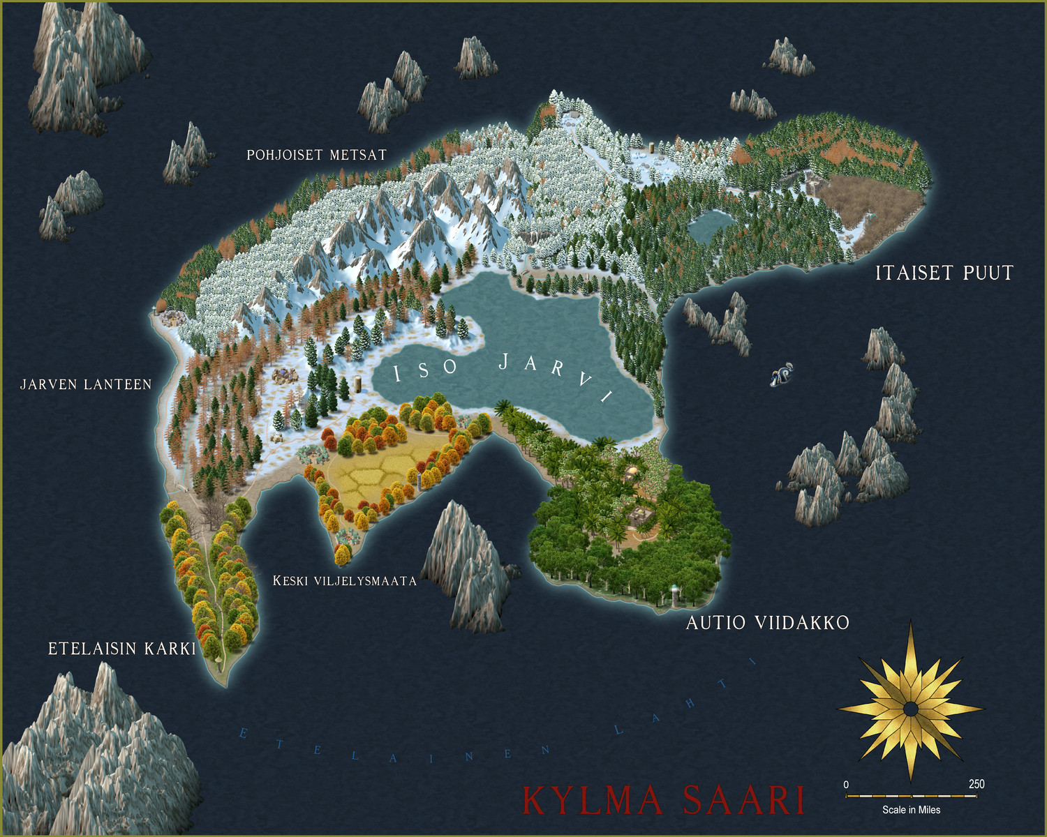
Was adventurous and decided to do my first map without using a tutorial. Enter the world of Kylma Saati (Cold Island in Finnish), an 1100x1500 mile island. I went very tree happy with this one and didn't focus as much on settlements/cities as much as I did aesthetic. I love what I made! I think that I happened to knock it out of the park. Some things I would change, I could have mixed the pine trees up a bit in the northern behind the mountains area of the map a bit more, they kinda contrast in a line which I didn't care for but oh well. Still really love what I came up with. (Higher resolution photo in my gallery.)


-
My first map!
I finally created my first ever map in CC3+. I still feel that I'm not overly familiar with the program (it will come in time, still very much in my CC3+ infancy when it comes to learning the ropes) but I am incredibly proud of what I made. Haven't explored a new artistic medium in years, and I'm very fortunate it came in the form of a map made in CC3+.
I closely followed this tutorial on the ProFantasy Software YouTube channel: https://www.youtube.com/watch?v=st_MEY3I12o
There were a lot of struggles along the way, I ever so famously couldn't get the hang of tracing (Thank you @Dogtag for the helpful video, and you @Royal Scribe for posting it!) as well as running into a couple of hiccups with the symbol menu (thank you @Loopysue !) however I chose to be resilient instead of ignorant and put my mind to the task.
I can see why all of you make up this community, it's incredibly fascinating and oddly therapeutic creating these maps and making friends with each other. It's an artform I never expected to thrust myself into, let alone enjoy. I'm excited for what the future holds for my future in cartography, whether it remains worlds that I create on my own, in collaboration with others, or possibly recreating real world places.
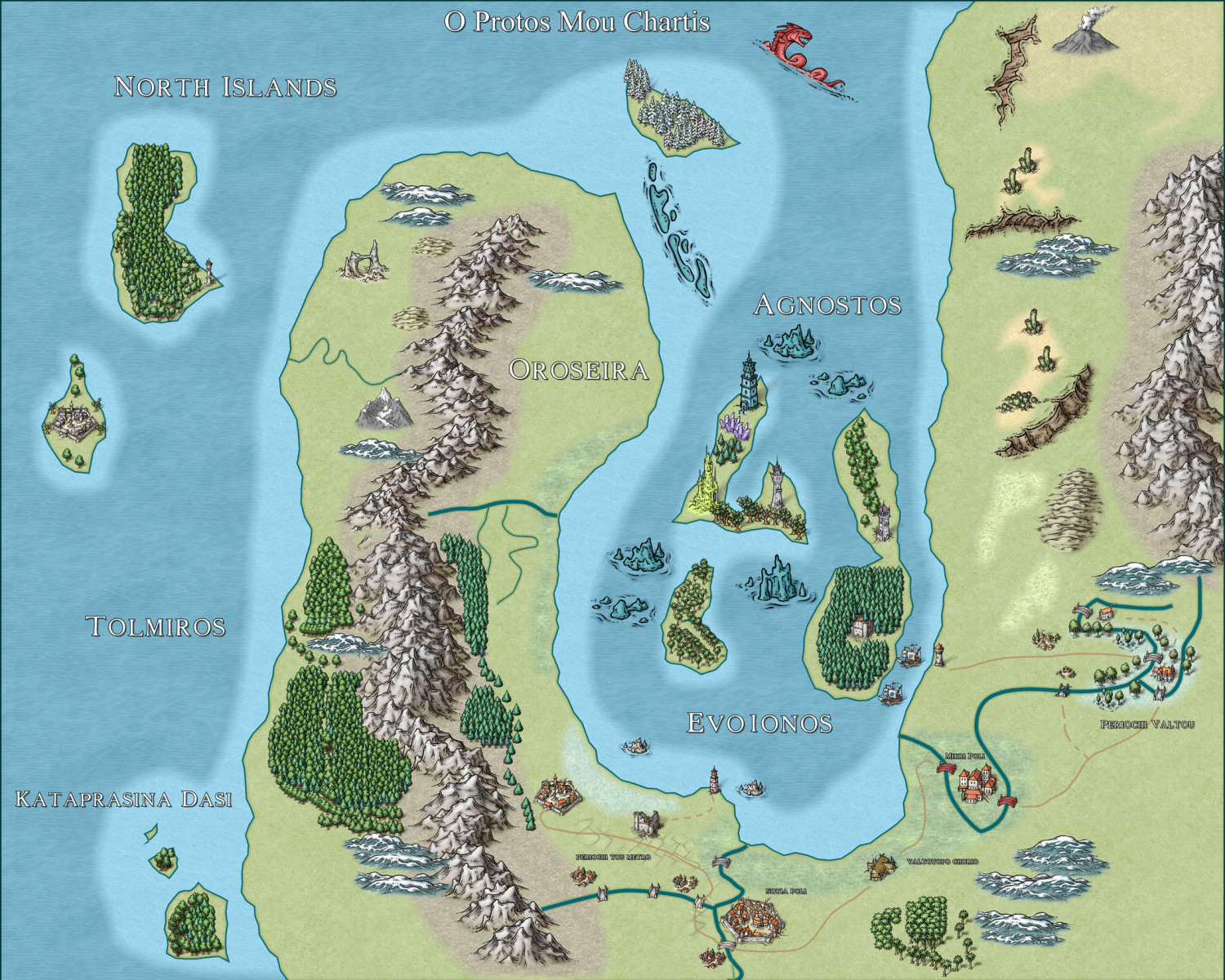
As for the map itself, I decided to use the Greek language as the basis for naming the different regions/areas of the map (seriously, does Greek ever NOT look/sound beautiful?) and they're words like "city" or "area" simply translated into Greek. I think my next map will be a central island with a heavy jungle and tropical theme as well as several smaller islands, as opposed to effectively a peninsula connected to a landmass and a few smaller islands (9, if my count is correct).
Errors I made/problems I encountered:
-Made the chasm in the upper right hand corner at an awkward/weird angle.
-Used too many of the snowy hills in regions where it wouldn't make sense given the climate (right next to the jungle warm areas and deserts, for instance)
-In the Periochi Tou Metro and Notia Poli districts I couldn't bring the two bridges the roads overlap to the front for some reason, I think I'll just not draw the road through them and rather just in the future cut them off before the bridge and draw it from the end of the bridge instead.
-The northernmost island in Kataprasina Dasi has a weird sort of cut to it on the south side of the island.
-Will note to start adding trees and such from the north heading southward, as I went all over the place in some regions and it shows the trunks of the trees overlapping the leaves of the trees south of it. (The keep on the easternmost island in the Evoionos body of water, for example)
-Didn't connect some rivers all the way to the coastline (the middle river of the Tolmiros peninsula doesn't connect fully to the Evoionos body of water, for example) and also need to have something added for the end of the river. A dam, for example.
-Didn't think about the colors I was using for some of the symbols. The rock features inbetween the islands of Evoionos for example, are the same color as the water. I should have made them gray. I don't knock myself for experimenting (that's what learning is all about, anyways) but as I progress I will continue to be more mindful of the color palette I choose.
-Did not really pay much attention to the positioning of certain symbols similar to the chasm I mentioned in my first bullet point, the sandbar in the northernmost part of Oroseira, for example.
-Did the same thing with the goofy sea monster. :P
-Similar to the second point I made regarding climate, I had the northernmost island of Oroseira a snowy like region with snowy trees and nothing else, even though I put cacti at the same latitude.
Thank you all so much for welcoming me into your lovely community! Here's a high quality version of the image via Imgur (due to the forum's image size restraints, but here's a picture fitting in those restraints as well) https://imgur.com/a/aeeP40x

-
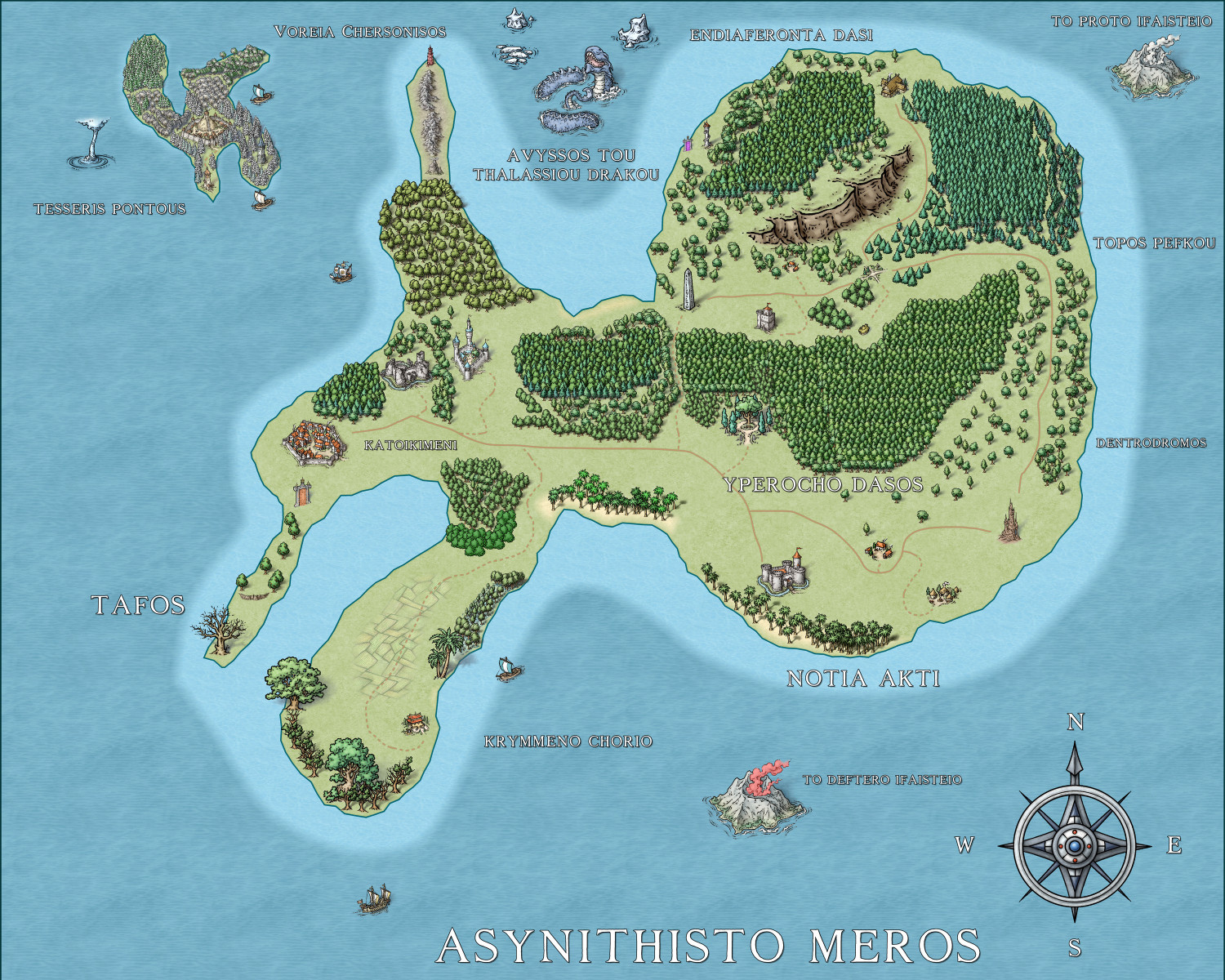
2nd map
Asynithisto Meros, or as it's translated from Greek to English "Unusual Place", is my 2nd map. With 13 regions from a southern swamp-like farm area all the way to a sea dragon's domain, I tried to reach out with this one a bit more.
I definitely went more tree happy this time around. I felt that I didn't do enough the first time around and now I feel that I've done the opposite, while leaving some areas perhaps a bit too sparse. I wanted to do something a bit more mysterious, hence the teleportation gates between Tafos and Katoikimeni as well as by Avyssos Tou Thalassiou Drakou. Used different architectural structures this time around, ranging from a walled city in Katoikimeni to a few castles, towers, villages, Elven structures, an obelisk, as well as the stronghold on Tesseris Pontous. Also added some volcanos, as well as trade ships.
Very proud of this one! Will upload a file-size appropriate JPG here and then a bigger file for my own personal gallery if anyone's interested.
Errors I made/problems I encountered:
-Perhaps could have added a harbor of some sort in several areas of the map. Not kicking myself for it though, not sure how to do that just yet.
-Despite being a tree happy map, I went WAY overboard with the trees on Tesseris Pontous that it looks clumped together.
-The coastline looks too jagged for Voreia Chersonisos, maybe could have added a couple trees here and there as well.
-Should have used a different volcano for each of the Ifaisteio volcanos.
-Probably could have done with another beach or two in Notia Akti.
-Put the 'W' in the compass too far to the left (my fault, should have chosen one with them already written).
-
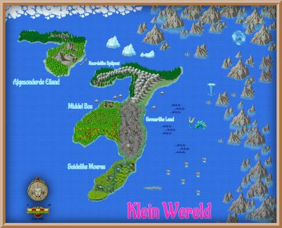
Map under an hour challenge
As everyone here is I'm very sure aware of by now, I'm very new to the art of cartography as a whole as well as CC3+, so with a few maps under my belt I decided to challenge myself in creating an entire map in under an hour! Though this is very standard for most of you expert professionals, it's something that I have yet to do so far. Until now! Here's my world (language I used this time: Afrikaans). I ran out of time and drew a lot of rocks, icebergs, fish, sea monsters, ice sheets, etc. but otherwise very happy with this. My favorite region is the swamp land! (Higher quality JPEG available in my gallery!)


-
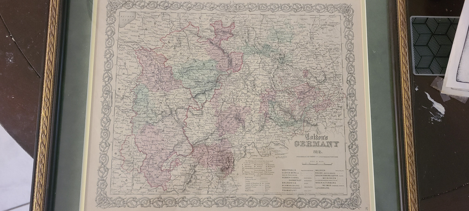
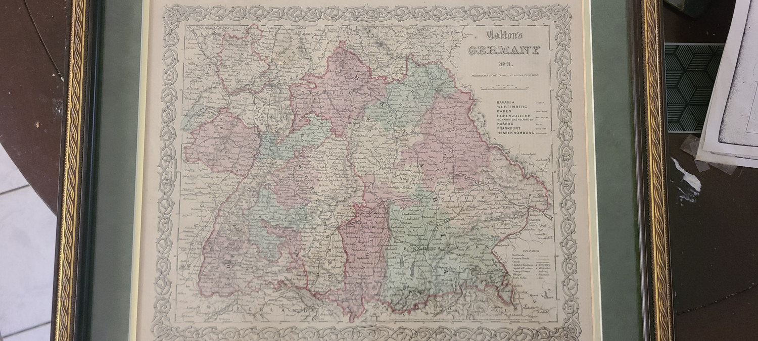
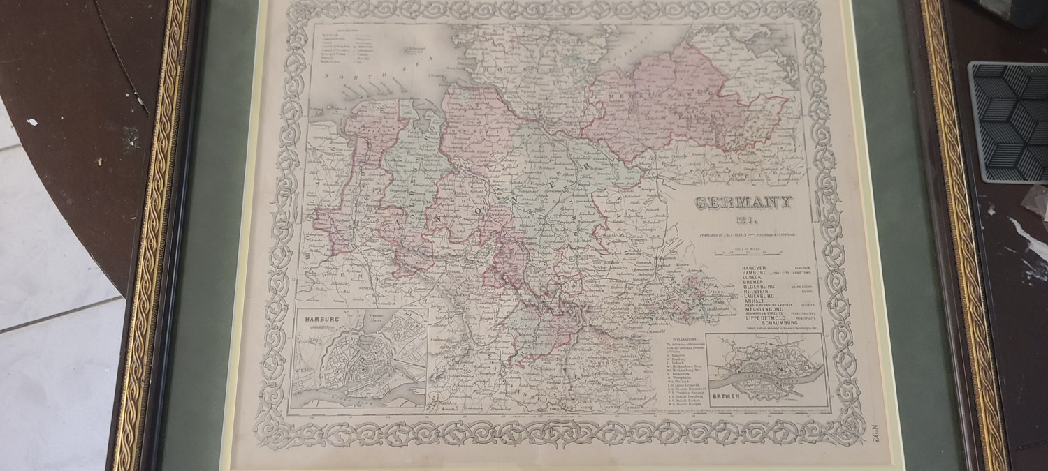
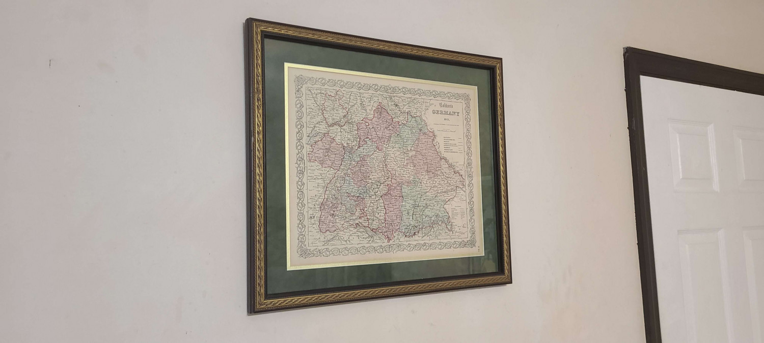
Show us your map collection!
I recently bought 3 maps on Facebook Marketplace of Germany circa 1864, I put one of them up on the wall and the other two I'm giving to my dad for his birthday and father's day (both within a day of each other).
What sorts of real world maps do you all own? Any that serve as influence/inspiration to your own personal cartography?
-
Can't seem to draw backgrounds
So I did watch this and it did very much help, but a few key points that I'd like to clarify for anyone struggling with this as much as I just was:
- When you hit T and it asks you for that midpoint area to click on, it has to be very near EXACTLY the actual coastline, not just anywhere on the land mass.
- When you're tracing from starting point to end point after having drawn your terrain, you ARE drawing it. The video states otherwise, and has you redraw which doesn't work and leads you to start over. All you have to do when you choose the end point is to left click wherever you want the end point to be and then immediately right-click to draw the terrain to adhere to the coastline.
- Remember to hit refresh afterwards as well!
But thank you for the video! Perhaps the person at ProFantasy who made the Live Mapping: Mike Schley Overland video could explain a bit more about tracing for their next video.
-
My first map!
Oh heavens no, just going to keep making maps and work on different things over time.
-
Issue with beach on Spectrum Overland
Thank you for all your help everyone! I decided to just erase the beach and draw it wider which worked! Thank you @Loopy , @Royal Scribe , @Quenten and @Ricko for your help!
-
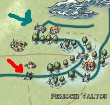
My first map!
The red arrow or the blue arrow one? The red arrow one is a broken bridge leading to an abandoned village, the blue one leads to the rest of the northern lands.