


jmabbott
jmabbott
About
- Username
- jmabbott
- Joined
- Visits
- 2,281
- Last Active
- Roles
- Member
- Points
- 1,846
- Birthday
- March 1, 1963
- Location
- Penrith, NSW Australia
- Real Name
- Jim Abbott
- Rank
- Mapmaker
- Badges
- 12
Latest Images
Reactions
-
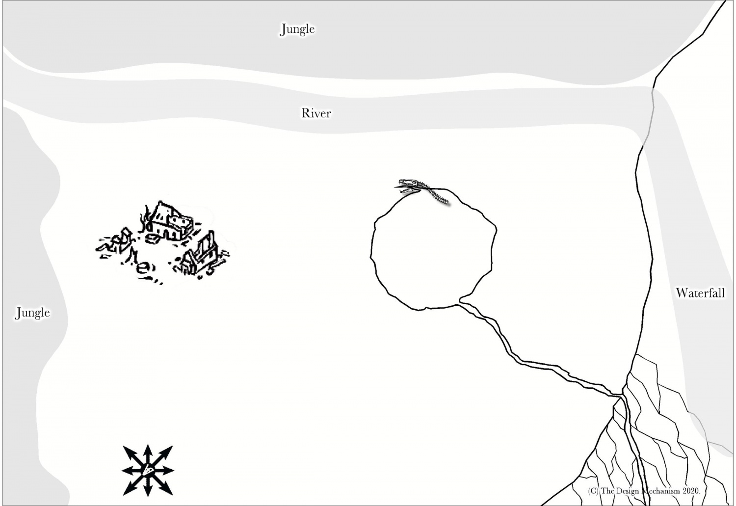
Commission WIP
Hi Folks,
Here is a WIP shot of the first map of my latest commission. The final map is to be 1/2 letter 300ppi PNG. It is a seaside plateau bounded by jungle and cliffs with a river and waterfall. A virtually, bottomless shaft descends to the depths. The remains of previous habitation lie in ruins.
The shaft gives access to subterranean levels via a steep, winding stair carved into the rock. The stair is accessed via the open mouth of an obsidian reptile like creature...
The design brief is old-school White Dwarf. For those of you who don't know, White Dwarf started as a general RPG magazine but now focus' pretty much solely on the Games Workshop range of products (mostly miniatures but I think it also may print some Warhammer Fantasy Role Play stuff as well). So, that being said the style is old-school B&W.
I'm using the Annual OSR style with symbols from various overland B&W styles as well as the Par Lindstrom B&W dungeon style. The jungle, river and waterfall are just place holder polygons at the moment.
Comments and critiques are welcome.

-
October Community Challenge - City Streets - VOTING POLL in first post
I'd love to take part but I've got a commission to do plus I haven't finished my city/town map for the atlas and hopefully my new campaign will be starting, so there is a fair bit to do there as well. Oh, and no doubt my wife would like me at some point, to spend some time with her...

-
Community Atlas - Blackrock WIP
Thanks Sue, for all your suggestions and help. I really appreciate it given your looming deadline for Spectrum 2!
I'll do a bit more and next time I post an update, I'll also post the FCW file, irrespective of whether or not I've fixed those pesky edges. I think the other terrain fills will work better as they're not 'background' fills...
-
Community Atlas - Blackrock WIP
Thanks Sue,
That's a great idea about the 'sketch sheet'. Also about considering demographics and food supplies as well. I guess, looking at the number of dwellings with a few extra to be added in for support workers; i.e more farms and a couple of extra houses for the dock workers, the population of the immediate town will probably be somewhere around 350-450 people.
There is a small cemetery behind the church but a postern gate could see that extended to just outside the city walls. Those buried within are the nobles and wealthier merchants, while outside is used for the common folk.
The plan was to have the stretch between the 2 lower cliffs given over to agriculture. The bottom right is where I'll likely put the compass rose (a custom symbol, nothing overly fancy, that also serves as my signature) and scale bar. The lower left portion is where the map key will go so while it needs something, that something does not need to be elaborate as it will be covered.
My intention is to do ALL my maps to a publishable standard regardless of whether or not they are commissions as I will most likely use them for things I self-publish. It's a matter of picking up the pace so that when I do have commissions to work on the hourly rate equates to something more reasonable than a cappucinno! I think CC3+, even at my stage of proficiency, is way faster than hand drawing in Ps; I knocked up a simple floor plan as an example for an indie publisher in a little over 45 minutes.

-
Community Atlas - Blackrock WIP
Ok. I tried another fill over those lines and it works but I wasn't happy with it, so I've left them for the moment.
I'm happier with the fields but still not 100% satisfied.
I played around with bringing in the forest fill from the Jon Roberts overland style and no matter how I scaled it, it looked rubbish. Then I played around with Symbols in Area (Exclude) and I must have had the symbol size too small, so I'll try that again with larger symbols.
In a nutshell, all I accomplished in about 2.5 hours was the fields and adding the road and changing the main road into the town and mine. I suppose for 2 hours of that I was pretending to be Alexander Bell and figuring out what won't work... Here's where I'm at at the moment.


