


mike robel
mike robel
About
- Username
- mike robel
- Joined
- Visits
- 4,196
- Last Active
- Roles
- Member
- Points
- 435
- Rank
- Surveyor
- Badges
- 6
Latest Images


Reactions
-
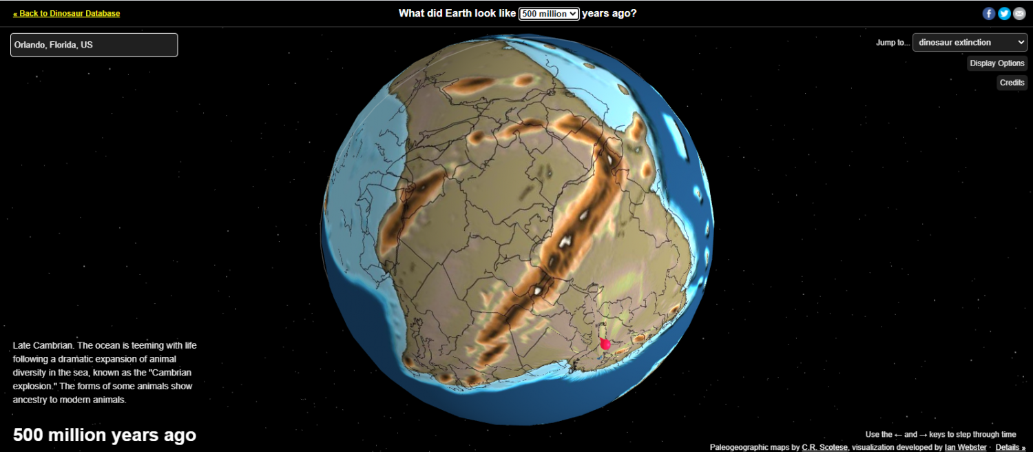
Global Map takes you from present to 750 million years ago
This site allows you to visualize the earth at various stages up to 750 million years and you can input a town near you to see how things change over time. An interesting perspective and it rotates, you can switch views, stop it. etc.
Those of you who like lighter colors higher will be pleased.


![[Deleted User]](https://secure.gravatar.com/avatar/c75d9a245b74d9c59be0999ea81ca541/?default=https%3A%2F%2Fvanillicon.com%2F92add7f8c954488718110edc4896ad39_200.png&rating=g&size=200)

-
Project Spectrum - Part 2
Nice. I think you should include Joshua Trees.


-
Here I go again ...
Photos of the map to date in its more operational environment, on the game table with some counters and dice for size relationships. The Hexes are 3km from side to side, about 4 cm, and the game pieces are 1/2in. Sorry for the mixed units.
I think the map looks better in the photos than it does on the monitor or even when I printed it out and looked at them sheet by sheet.
I tried to load the Bitmap FIlls from the WWII Area Maps to change the forest green to the deciduous and pine fills, but they came out much difference in appearance, so I I'm trying to figure out what I did wrong. They were just a blob with none of the texture. Nor have I enabled the contour levels with an outline. I am getting closer.
-
Little Bighorn Battlefield Map
I printed and assembled the maps and you can see them below with some counters on them for effect. The game is a long way from being published. There are 2 or 3 more things in the queue before I get to this one. The table is 5 feet square. The boards are the anti-cat and wife protection for another game underneath.
The third photo shows a close up of the high contours with the transparent vegetation. I think it might be okay like that when printed out.
The fourth and fifth are just other views of the battlefield.


-
Little Bighorn Battlefield Map
At this point, the map is at a stopping point while I move on to other projects. As one can see by the title, it is the area in which the Battle of the Little Bighorn (aka Custer's Last Stand) was fought. I need to tune the road network, consider if I want to place buildings and other objects on the map, and add place names. I really like the way the shaded contour areas define the terrain and combined with the water courses and the vegetated areas, highlight the ridgelines and draws.
The map will be for a science fiction game based on Hammer's Slammers stories by David Drake (with his permission).
My quandary at this point is the vegetated area. As the map is drawn right now, those areas are solid. The drawback is they block the contours of the map, as can be clear seen in the lower right corner of the top image. The alternative is to fool with the transparency, and the second image shows that. I think it makes the map look like it has small pox or something and the vegetation since it is fairly light, seems to blend in with the terrain. The last image shows a close up of the lower right with transparent terrain.
Alternatives:
1. Just leave it solid and be done with it.
2. Fiddle with the transparency and accept how it looks.
3. Split the vegetation layer into two layers with one area covering top or left side and the other area covering the bottom or right side and have the transparency different. I think this would give the map a very odd look.
4. Go through and convert all the vegetation to Polygons with no fill, leaving only the border, then fill the polygon with symbols, and then convert all the polygon boundaries to no line. This would probably give the best artistic look, but would be tedious. It also would potentially put non-topographic symbols on the map (if I use top down tree symbols) or look kind of weird if I used the available topographic symbols for various types of vegetations, mostly deciduous trees.
5. Convert the contour polygons so they are hollow and then place them over the vegetation symbols. This has the draw back of making it more difficult for some people to visualize the terrain. Many game players don't really know how to read contour lines. (I find it interesting for instance, that Google Maps/Earth don't have them.)
At this point, I am sort of leaning toward option 4. It requires Brute Force and Ignorance to get through, I think, but some say that is what I excel at to get through notty problems. It will take a lot of fiddling to get the fill to look right and at some points, for very small regions, I may just manually plop the symbols down.
I'd appreciate comments and other potential solutions.


