


Wyvern
Wyvern
About
- Username
- Wyvern
- Joined
- Visits
- 3,303
- Last Active
- Roles
- Member
- Points
- 5,647
- Rank
- Cartographer
- Badges
- 24
Latest Images


-
A Hand-Drawn Fantasy Map of Jack Vance's Dying Earth
Thanks very much, Sue! It's the style that does it really though - and that's down to Ralf!
-
A Hand-Drawn Fantasy Map of Jack Vance's Dying Earth
Closing-in on the final stretch now, with only that southeastern quadrant to complete.
And lo! The coastal lines did resume their former appearance (again, no idea why, but I'm not complaining!):
There was also one new addition here, although it may not be all that obvious. It happened when I realised I'd not added the background shading polygons to the huge Fer Aquila to Black Maurenron Mountain ranges, or the Chaim Purpure one. That realisation came about after preparing the notes regarding these very background area fills previously! I went on to add a few more similar patches to the smaller clutches of hills elsewhere in places, helping to soften the landscape a little more (e.g. in Kauchique).
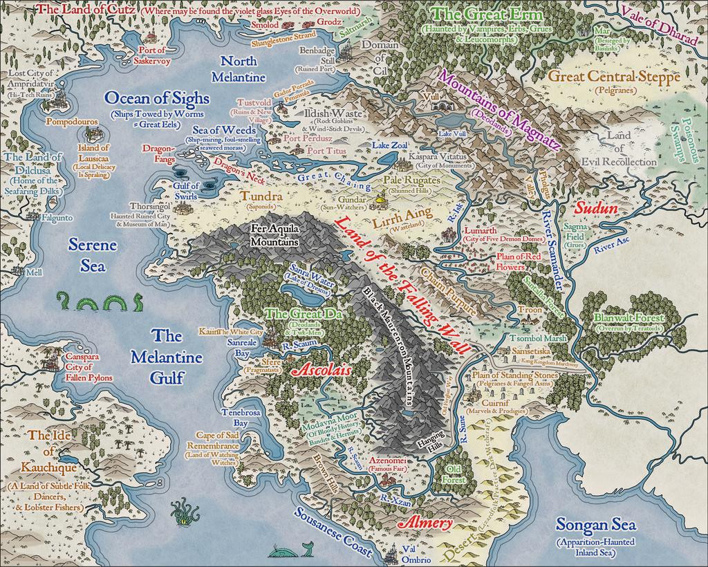
All of which brings us to the final version of the map, as luckily, those last areas needed fewer labels in them, which, as mentioned previously, always seem to take the longest to get right. A higher-res version of this is in my Forum Gallery:
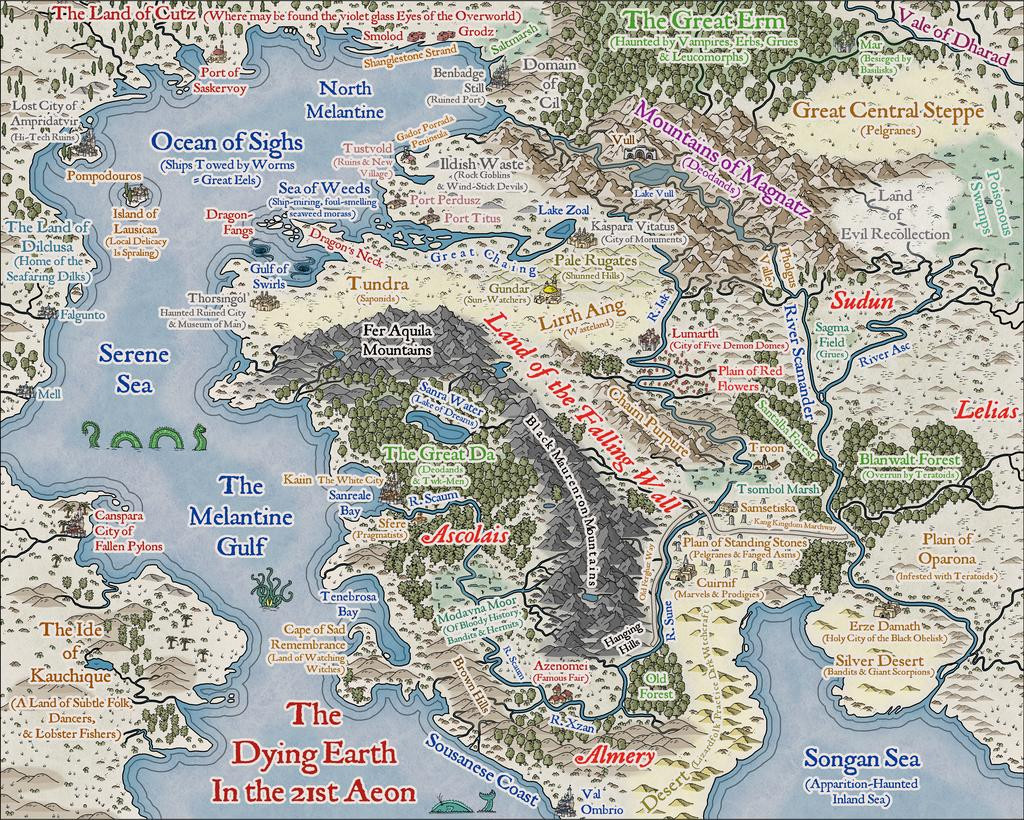
This was all rather fun, and as good an excuse as any to revisit some of the tales, and explore both the Goodman and Pelgrane RPG materials more fully, to pull together the on-map notes for my version, for all it was heavily based on the Goodman Games map.
Naturally, on reflection, there are features here that seem a bit odd, due to how that guide map had been drawn. That "Great Central Steppe", for instance, seems neither very great nor central, but of course compromises have to be made when trying to pin-down on a map things that have been extracted from a literary source, where imprecision in describing such things was to be expected, and sometimes intended (because such details were often given by characters in the stories who may not have known the information anyway, or had deliberately altered it). You'll notice too that those two later sea creatures had to scoot aside as the map's title dropped into place!
No scale or compass rose were added. The scale issue was mentioned before, as not featuring on the Goodman Games map, which also had no compass pointer. Distances in the stories tended to be glossed-over a little vaguely anyway quite often (for instance, the distance between Canspara and Ampridatvir was noted as being a thousand leagues in one tale, although what constitutes a "league" here is anyone's guess, so essentially "a very long way" - rather like the real-world, as a league is a distance measure that's had different definitions at different times and places). I did trial a compass rose briefly, but the only suitable spot was in the lower-right corner, where it looked awkward without shifting the "Songan Sea" labels (so those then looked odd!), or making the rose too small to seem useful.
I'm thinking now of revisiting this in future, perhaps with similar reworkings of the alternative Dying Earth maps from elsewhere, and/or compiling a variant of my own. Though I really should get back to some Atlas mapping again now 😁...


-
Live Mapping: Gritty SciFi Blueprints Prt 2
And 🤞 that Ralf's Internet holds-up better this time!
-
A Hand-Drawn Fantasy Map of Jack Vance's Dying Earth
I was going to leave a discussion of some of the text items to my closing post on this topic, but since that's not quite ready yet, and as the subject's been mentioned, we can today take a closer look at...
The Kaiin Mutiny*
Using text in Campaign Cartographer can often raise issues, and is typically one of the most complex elements. Aside from variables such as which font to choose, the font size for particular labels (as only one size can be allocated to each text item), suitable colouring and effects, the placement point can often be the trickiest to get right. Text will tend to expand away from whatever placement point is chosen at different screen and image resolutions - if that's "Mid Left", the text will usually hold fast on its left side, expanding away to its right, for example. This can only be fully overcome by using the "Explode" command on the text, to convert it to graphic entities that will hold their positions correctly. While this has advantages sometimes, it has the serious disadvantage that the text can no longer be edited as text, so make any mistakes, and the whole rigmarole must be gone through again.
In this case, I was using two different font sizes, and thus separate text items, for many of the map labels, larger for the place-name, smaller for the notes. The Kaiin label was an especial problem, because at the place-name font size, there wasn't enough room to fit the full text line in due to "The Melantine Gulf" label. So I reduced the font size for "The White City" part, and set-up the two parts of the name-label aligned, but with the intended fixed placement points of mid-right for "Kaiin" and mid-left for "The White City". It looked fine, as this screenshot from the FCW file shows:
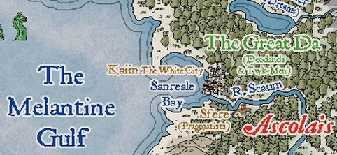
However, rendering the map image as a JPG at the normal Forum resolution, and it came out like this:
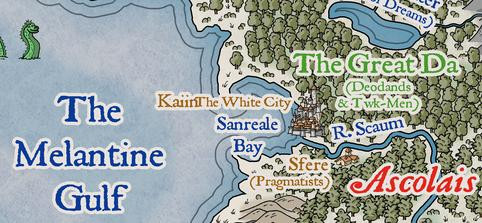
This is unusual, but I didn't spot it right away, hence why it appeared on the map images posted last time (and again in one of the WIP images still to come). Typically, once I think a map's completed, I do a trial printout on an A4 page, so I can check it for mistakes, rather than relying on just on-screen images. Which is where this little "delight" was noticed. Checking the FCW file showed that "The White City" had been given a mid-right placement point as well as the "Kaiin" one, which I'd guess was due to a mis-click on my part; luckily, easily corrected, as this sneak-preview of a later-stage-mapping image shows:
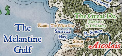
One further point about the map labels should be noted. As often happens with such labels that have effects on them, when placed over mapped features with a very similar to identical colour, that can cause the text to lose definition, or gain unwanted holes and marks. When I spotted that first, for the "Fer Aquila Mountains" label, I decided to duplicate all the on-map texts to a lower sheet without effects on it, which stopped the problem in its tracks. That did though help slow-down the whole labelling process subsequently, both in remembering to do it on a per-label basis, and when the label's placement point, font size, or appearance for multi-line texts, had to be amended after adding it. Which, of course, is partly why the Kaiin Mutiny was allowed to continue for so long 😉!
* A punning reference to the title of an old Humphrey Bogart movie.😎
-
Problems with Ferraris Style Example Maps Crashing - Solved
As I noted on the Forum yesterday, in trying to help resolve a different issue someone was having with the Ferraris Style (from Cartographer's Annual 158), I ran into issues with the program crashing if I tried to open the Vegetation.fsc catalogue. Rather than continue hijacking that topic here, I felt it better to start a new one instead.
The key elements of the problems I had, as extracted from that other topic below here, were all discovered just using the two example maps from that CA issue:
The Village of Greythorne map opens, but if I try to access the vegetation catalogue, the program crashes and auto-closes-down. If I try opening The Ferraris Style Legend.FCW, it starts to open, then crashes and closes too. I've done a full repair reinstall, with exactly the same results.
I have created a new map in the style as a test. If I click to open the vegetation catalogue by the button, or navigate to it using the right-hand symbol pane button, it crashes. If I open the "All" symbols catalogue, it's fine, and I can see and access the vegetation symbols perfectly OK. There seems to be an issue with the Vegetation.FSC file for some reason. I can also navigate to the two example files in the style using the opened new map file OK as well - as long as I don't click the vegetation catalogue button! However, if I try to open the Legend example file directly from the Program Data => etc. option, it crashes after opening.
As our resident Forum expert Sue Daniel was unable to recreate the problem, she suggested I contact PF Tech Support, and having done so, I had a reply from Ralf this morning. He WAS able to reproduce the problem, and sent me a replacement Vegetation.fsc file to test, and that HAS solved the issues, so the program no longer crashes. However, he mentioned too being uncertain as to what was causing it; possibly something to do with one or other macro implemented with the drawing tools.
If others run into the same issue, at least you'll know it can be solved, and can hopefully be resolved in the download file before long as well. Providing this solution hasn't thrown-up another problem I've not spotted yet, at least!

