


Wyvern
Wyvern
About
- Username
- Wyvern
- Joined
- Visits
- 3,266
- Last Active
- Roles
- Member
- Points
- 5,585
- Rank
- Cartographer
- Badges
- 24
Latest Images


-
[WIP] Republic of Lumadair (Ancient Realms Revisited)
I'd agree with that I think - the wyvern's larger and clearer, thanks to the thicker drawing lines, and the "Shessar Heraldic" beasts are closer in general style to the roundel designs too.

-
Community Atlas: Aenos Isle North, Demosthenes Swamp, Artemisia
The final stage of this group was the lower level partly beneath the Great Temple, which both sections of the upper underground complex link into, Thalagos Cavern:
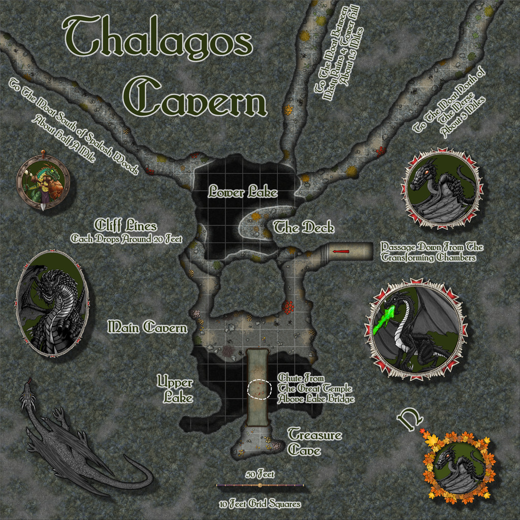
The base layout was from the Inkwell dice, as noted in my first posting above, with a few minor tweaks, notably extending those three straggling exit passages, which lead off-map for some considerable distance to the inner edge of the swampy Moat surrounding the higher area on which Threshorsh is set. The passages are all mentioned as being flooded in their latter stages in the accompanying notes for the Atlas version, and all emerge under the swamp, so there is no easy means to access the Cavern from outside that way.
Since the Inkwell dice designs are set on a geomorphic grid, that does make it quite easy to connect with other such layouts above and to the side like this. Indeed, I simply copied and pasted over the chute from the Great Temple and the floor from the Cavern Access passageway in the Threshorsh map to this one (both of course are drawn to the same standard Dungeon "in-feet" scale), to make sure everything linked properly.
Creepy Crypts was the base style used for the map, giving some interesting additional rocky textures, and while the walling system takes a little getting used to, it had the advantage in this map of allowing me to very easily add those steep-drop Cliff Lines simply by copying the sheet effects to a couple of new "Walls-but-not-really-walls" sheets (I didn't call them that!). Then by tweaking the water effects a little, it became possible to show the shallower sloping shores around Lower Lake too - the pale lines - leaving the shadowy darkness of the cliff-drops to show where those were - including all round Upper Lake.
Fun times were had adding all kinds of patches of mould, assorted splats and stains, and a few small treasure piles, to parts of the floors, along with some significant clumps of fungi. Some of the moulds and fungi are bioluminous too, which were among the randomly-obtained features to add to this map. And yes, sacrifices do occasionally find their way down from the Great Temple to the bridge top above Upper Lake (though not perhaps as often as you might think). The trickiest element was the scaling grid, largely because this never seems to work well in narrower, variable-width cave passages. I did try it as more strongly visible at one stage, and considered a toggle to let it be turned off (as it just looked too strident). Ultimately though, I felt this subtler version worked OK, and should anyone need to brighten the grid, the FCW will always be available in the Atlas.
There was a lot of space around the layout too, so I added some of the DD3 "holey" textures to change it up a trifle, and added a few more, and larger, TT1 options than I'd anticipated at the start - even a varicolor DD3 dragon, if maybe one a bit too robust and "wing-y" for the Swamp Dragons as I'd been thinking of them. I did consider reducing the length of the exit passageways, but I wanted to keep the labels for them on the map, so left things alone finally. Plus I did rather like the vaguely spiky-tentacular look this gave to the whole. Though that's probably just me!
Ordinarily at this point, I'd mention where I'm off to for the next "Adventurer" dice set of designs. However, we're having a short excursus from that, as I've brought forward the mapping for the "Ruins" 6R* dice-face design (which you may recall I mentioned when using the unruined version of this, from the "Cities" dice-face 6R, for the Seer's Hall Village map previously). That will be going onto Lizard Isle, a large island offshore of southern Alarius.


-
Birdseye Continental - style development thread
Yes, I agree with Don about the first version.
For other volcanoes this is a usefully-illustrated introductory US National Park Service website that has links to other similar pages with more information that may help give you a better idea of volcano appearances overall.
-
WIP: Bleakmoor Harrow - Continent of Estonisch
I actually think the trees work really well with the water texture right now. To my eye, the problem is the abstract nature of the land and settlement markers outside the marshes (the dots, NOT the Ancient Realms circular symbols, which are fine), and especially the coastal edge and sea lines with the water texture there. Those really jar to me, as compared with the near-photo-realism of the marsh water and trees.
As Ricko wrote though, it really depends what the viewing level will be for the final map.
I can't usefully advise you what I'd do, because I don't design maps the same way as this, so the situation doesn't arise. I tend to pick a style I like for what I'm intending to map (or sometimes several matching styles, or complementary ones that are sufficiently similar to work together), and draw accordingly. I might add a few symbols or fills from elsewhere that aren't in the original(s), or repurpose some that are to be different from what their labels indicate. That's not the same as what you're trying to create here though.
-
WIP: Bleakmoor Harrow - Continent of Estonisch
Conversely, I think the trees work rather well with the watery swamp texture currently, though those don't work quite so nicely with the other textures involved. This can be a problem when trying to mix styles, of course.

