


Wyvern
Wyvern
About
- Username
- Wyvern
- Joined
- Visits
- 3,266
- Last Active
- Roles
- Member
- Points
- 5,585
- Rank
- Cartographer
- Badges
- 24
Latest Images


-
Birdseye Continental - style development thread
Ah, the Star Trek mountains (well, they're shaped a bit like the arrowhead badges anyway!) 😎

-
[WIP] Community Atlas: Snakeden Swamp, Lizard Isle, Alarius - Dedicated to JimP
Thanks very much folks.
Ideas and concepts for this little map group just seemed to fall into place around the time of Jim's death, and Jim's insatiable mapping efforts and enthusiasm, both for the Atlas and his other numerous projects, had already helped maintain my own focus on the Atlas mapping I'd embarked on, albeit at a far slower rate than Jim's. So it all started to seem as if it was somehow intended.
As I'd already mapped something for Kraken Island in Jim's Forlorn Archipelago last year (Haunted Cloud Mesa), and as the locations for all these D24/D25 maps were decided a year ago, I didn't want to switch sites for this one, as I've set things up to only place one map (or map group, where there's an area map as well as the dungeon one) per regional area selected.
Ricko's already suggested an additional map of his own for another spot on Lizard Isle, and will post that here shortly, I think.

-
[WIP] Community Atlas: Snakeden Swamp, Lizard Isle, Alarius - Dedicated to JimP
With the location selected, I extracted details from both map versions, as shown by the following pair of images covering just that 20-mile area, now gridded-up into number-labelled one-mile squares. The red dots indicate which were to be randomly allocated some new feature or other. The red star is where the main 6R* map will be going eventually, more or less in the centre of the ruin symbol (as in my previous post, the SS1 map is again the lower of the pair):
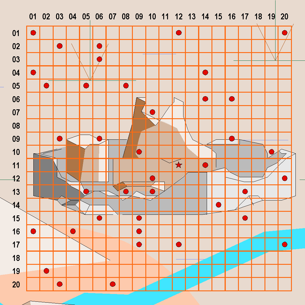
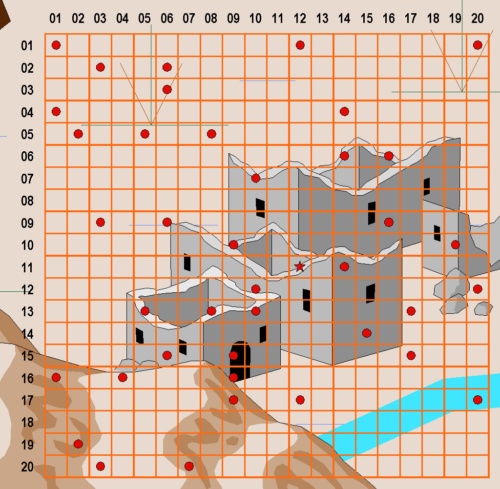
I prepared these two versions, as it wasn't always clear when zoomed-in this far where some of the pre-mapped features were, aside from the variation in shape and size of the ruin symbols in each. Much of the area is covered with swamplands, and as the location is at roughly 7°N latitude (the equator line is shown on both versions of the full island map), that means equatorial-tropical conditions. There are though hills to the southwest, and a major river to the southeast, plus of course that "huge" ruin.
From early on, I felt Lizardfolk would be the suitable main humanoids here, largely from the island's name and location, coupled with what some of the random-feature rolls had indicated. I was using a combination of items determined from tables in "Dread Thingonomicon" and "Dread Laironomicon" by Raging Swan Press, as also for the recent Artemisia maps, and some from Atelier Clandestin's "Sandbox Generator" and supplements, that I've used from time to time in this project before. Plus I'd also been thinking a lot about Lizardfolk more generally because of the set of Artemisia swampland maps, as they were the dominant humanoids there.
Oversized symbols are a fact of life with many fantasy mapping styles. There's often a general assumption that the actual feature illustrated will be located around the mid-point of that object on the map, and not be of the same apparent scale-size as shown by the map. Even so, it can be interesting to think beyond this sometimes. I did that with the weirdly gigantic barrows in Feralwood Forest elsewhere in Alarius earlier in this project, for instance. Here, the fact both symbols chosen for the ruins were town-sized, and not something smaller, set me thinking that scattered over a roughly 20-mile-square area, this might once have been the site of a city-state-sized realm, and so maybe there'd be other ruins besides the main "central" one I'd be mapping later, in other parts of the area occupied by the original symbol. Random-feature table options were then selected appropriately for that idea, as I came to think it would be interesting if outsiders might get the mistaken impression this had once been a gigantic settlement of some kind. The surrounding swamplands create an ideal means to mask that former reality here, if it was, of course.
With the preliminaries sorted, it was time to start mapping - next time!


-
[WIP] Community Atlas: Snakeden Swamp, Lizard Isle, Alarius - Dedicated to JimP
Following the recent death of our long-standing regular Forum contributor, and most active Community Atlas mapper, Jim Pierce (JimP), I felt it would be appropriate to bring forward this small group of maps from my sort-of Dungeon24 project for the Atlas (now of course Dungeon25), and dedicate them to Jim's memory. They were already being planned while I was preparing those recently completed for the Demosthenes Swamp region in Artemisia, as while drawing the Seer's Hall Village map, I decided to use as its base the design from the Inkwell Ideas Dungeonmorph Dice "Cities" dice-face 6R, even though the "Ruins" dice-face 6R* version of that design was already intended for Lizard Isle, off southern Alarius. Working on the intact version set me wondering about the ruined one too, and ideas started to coalesce for that as well. Ordinarily, the 6R* map would have followed only much later in this project otherwise.
When I looked at the Lizard Isle map in the Atlas, I discovered it had been mapped by Remy Monsen for the second anniversary of the Atlas using the original CC2 mapping style, and the variant CC2 fantasy overland style from Symbol Set 1. That decided me to also construct this small set using similar "early CC" mapping styles, as something I'd not attempted before. The reason this linked with JimP in my mind was because such early styles reflect Jim's longevity as a CC mapper - longer than those still active as mappers with the program can now recall - and his longevity with role-playing games going back to the very earliest days, which latter was similar to my own. In addition, Jim was often keen to go with "no frills" mapping styles to sketch his ideas quickly, which again is reflected in the relative simplicity of such early drawing modes.
Further to that, although I'd already derived lists of items I wanted to include on the maps and in their descriptions, and decided where things were to go at least loosely, I'd not begun any CC mapping, so this topic is going to be something of a work-in-progress effort, something else Jim was noted for on the Forum, albeit I cannot match either his speed in mapping, nor his regularity of posts here. So as with this being a sort-of Dungeon25 project, this is a sort-of WIP topic!
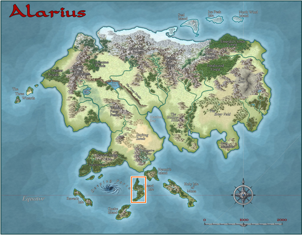
This is where Lizard Isle is:
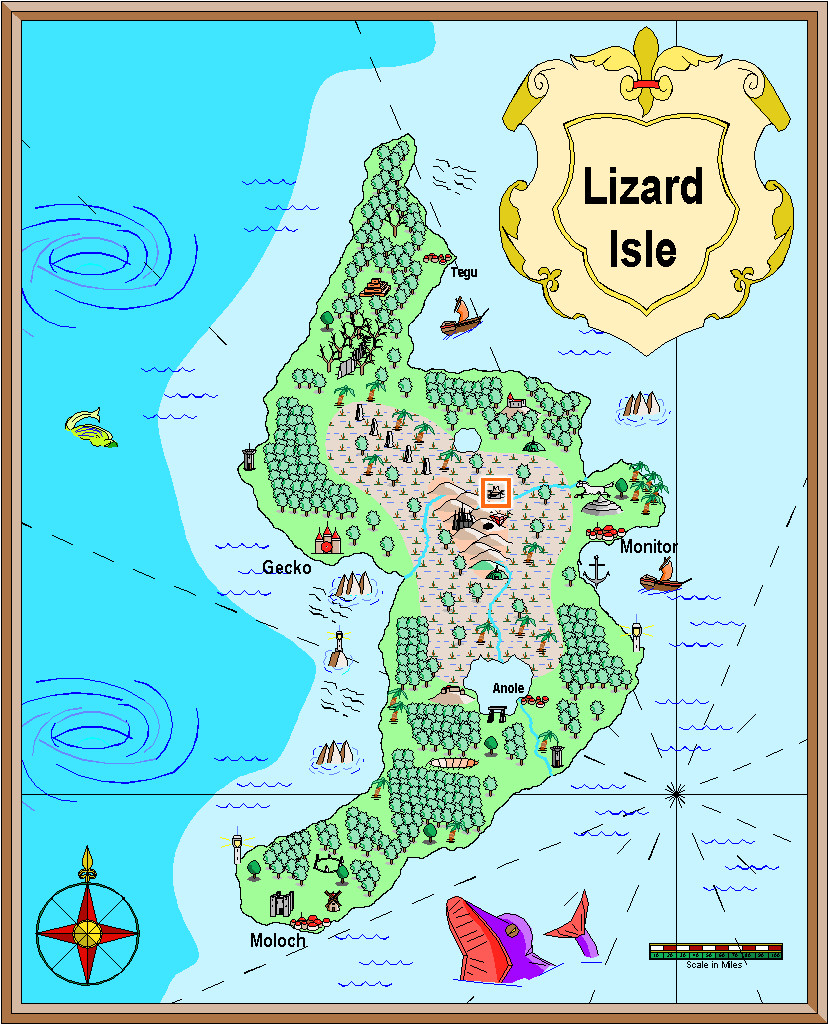
And this is how it was mapped, along with the location I chose for these maps, the small orange square in the north-central area of both versions. "Small" is relative at this mapping scale, however, as that square is really 20 miles per side. The fancier SS1 map is shown in the second image below:
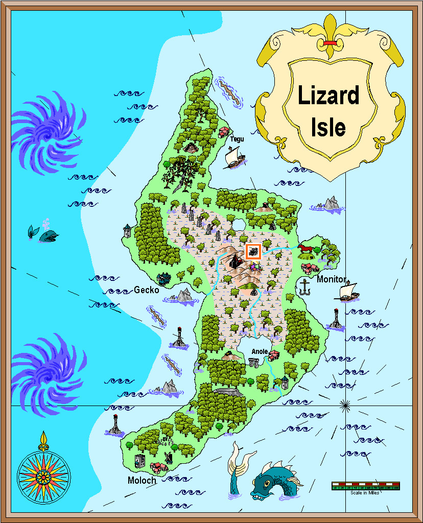
It may not be obvious at this resolution, but my chosen feature is a ruin symbol, as might be expected, given the base map I'm working with is also a ruin. The first shows a large ruin (there's also a small ruin in the style), while the SS1 map has a ruined town symbol (and there are ruins available in the style from city down to hamlet, castle, keep and tower in size), so that helped establish better what would be appropriate here.


-
Free Late Victorian PDF Maps From Chaosium
We've mentioned before on the Forum that Chaosium provides a lot of free PDF resources that you can download from their website for the various RPGs and supplements they produce. Today, I picked-up a physical copy of their latest Call of Cthulhu book at my FLGS, "Cthulhu By Gaslight - Investigators' Guide", the updated version of an earlier work for the line in which our own ScottA had a hand back in the day!
With the book comes a beautiful fold-out map of late Victorian London drawn by Alyssa Faden, a name doubtless familiar to some here, especially those who have her style pack from the 2014 Annual. You can download a free PDF version of that London map (and a set of the players' maps from the book, which share a similar look) via the links on the Cthulhu By Gaslight webpage here.


