Wyvern
Wyvern
About
- Username
- Wyvern
- Joined
- Visits
- 3,303
- Last Active
- Roles
- Member
- Points
- 5,647
- Rank
- Cartographer
- Badges
- 24
Latest Images


-
[WIP] - Atlas - Doriant - Gold Coast - Gongodûr - Arbor Hollow - Dwarven Townhouses
Labels are simply perennially tricky, I think. There are just so many variables involved, not least where different background colours against which they may be displayed in the same drawing are involved. I know this isn't just an "us here" problem, as I see similar issues from time to time on professionally-published maps as well - including things like the UK's Ordnance Survey maps, for instance.
I don't think there's an easy answer, beyond just to keep experimenting and see what works better for you!

-
Style Suggestion: Dungeons and Kittens
Thanks for the information re Call of Catthulu. I was basing my comments on what the FLGS manager mentioned to me, as regards what happened to it. There are too many RPGs now to try to keep track of any but a handful in detail, I find!

-
[WIP] - Atlas - Doriant - Gold Coast - Gongodûr - Arbor Hollow - Dwarven Townhouses
Looks good & golden!
Labels are never easy. I seem to spend more time on these, tweaking the font, colour, size, placement and effects, than just about anything else. These probably look fine on a higher-res image, but some - especially those on the palest stone background - are getting a little "lost" to my eye.
Oh, and on the "Private Residences" list, I think there's a missing space in the "10. Entrance" line.
-
A. Wainwright's Walking Guide Map Style
A repeat of a TV series on hill-walking in the British Isles this past week reminded me of another mapping style that might be worth examining here, a hand-drawn pen and ink style developed by the author and artist A. Wainwright for his extensive series of seven walking guides to the fells of the Lake District, published between 1955 and 1966, based on his own hill-walking, sketching and researching, beginning in the 1930s. While drawing heavily on the UK's Ordnance Survey maps, his own maps take a more pictorial view of the landscape. This is a typical double-page spread, extracted from this Eye Magazine webpage (itself worth a read - and to see another of Wainwright's mapping techniques, showing the distance and direction of other peaks from a given place):
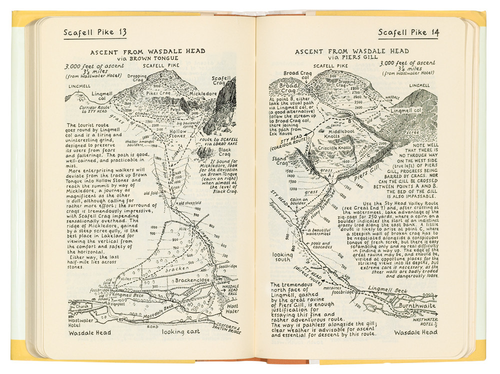
Yes, the books are also all neatly hand-written, not typeset as well!
What we have is a largely top-down view of the landscape, complete with contour lines, but the hilltops themselves are turned ideoplastically to be as seen in profile when approaching from below in the direction shown, and are often much more artistically drawn.
The books remain in-print, now in updated versions, while still presented in exactly this style, mostly as created by Wainwright himself (who sadly died in 1991, three days after his 84th birthday). The only main difference is now the recommended paths are shown as dashed lines of different styles in red, not black, as here (from the images shown on this Needle Sports webshop page):
Much of this could be accomplished using CC3+ now, of course, barring the artistic hilltop aspects, although it might be interesting to have it cast as a specific style at some point, especially as it highlights small regions only, rarely more than a couple of miles (3 kilometres or so) across. (I know B&W mapping styles are often less-favoured, unfortunately, albeit not by me!)
There are more examples, and further details about the man and his guides on this Wikipedia page and on the Wainwright.org website.


-
Ferraris Style MERGE Layer Problem
I discovered when using the Ferraris Style (CA158) over the weekend that clicking any of the symbol catalogue icons, except the Minerals/Mountains one, automatically changes the Layer to MERGE. Clicking to change the symbol catalogue by the manual system (the button between the "Options..." button and the currently-visible symbols) does not force this change however, keeping the Layer as whatever is currently chosen.
For anyone unaware, having any new items added to the MERGE Layer is an extraordinarily bad idea, as this Layer is part of what helps control the map effects. Unfortunately, it's very easy to accidentally do this because of this unexpected defaulting with this style.
Luckily, I spotted it before I'd added more than a few symbols, although it took a while to discover it affected all but one of the catalogue icons, and it was easily remedied, but ths behaviour is something prospective users should be aware of!