


Wyvern
Wyvern
About
- Username
- Wyvern
- Joined
- Visits
- 3,267
- Last Active
- Roles
- Member
- Points
- 5,585
- Rank
- Cartographer
- Badges
- 24
Latest Images


-
Pen & wash question
Realistically, and much as Sue already said, if you're aiming for a hand-done pen and wash style illustration, it should look like a watercolour painting, where the wash sometimes covers the line, sometimes runs short of it. There isn't a voting option for that, and I really don't see this as an "either or" choice. So sometimes that'd be "A", sometimes "B", but more often a mix of both, with some additional overlap too.


-
How to remove white line on smooth polygon river; Herwin Wielink Style
It would be good to see the finished map at some point, if you'd be willing to share it. It's impressive enough now, and there are some wonderfully inventive touches - I think my favourite is the use of the Mike Schley grazing horse symbols to spice-up the look of the farmland!

-
WIP - Liosach
The cloud symbols Sue mentioned are in the Alyssa Faden Overland style in the 2014 November Annual. Been using it myself recently!


-
Community Atlas: Errynor - Meteorite Coral Cavern
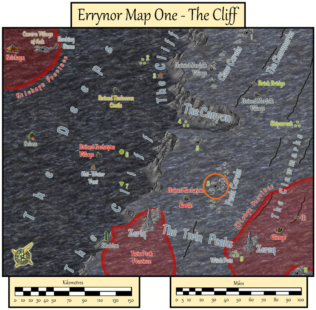
Having spent much of 2020 preparing detailed maps and descriptions that often took weeks at a time to complete for the Community Atlas, it seemed worthwhile to tackle a less involved map at this stage, for one of the smaller projects I'd long had in mind as part of Errynor Map 01. There, it had the prosaic label of merely "Cave 8", the lair for a giant octopus set among the Peak Corals:
However, for some time, I'd intended to make it a little more than simply an animal lair. Indeed my earlier planning for the maps to add detail to this Map 01 area had included others of the cave lairs elsewhere on it too. As time passed, I'd discarded that prospect as liable to become too similar, either because I'd end up frequently drawing small cave maps, or because I'd be struggling to make each one somehow unique. So this map ended up with a concentration of elements from some of those "cancelled" maps:
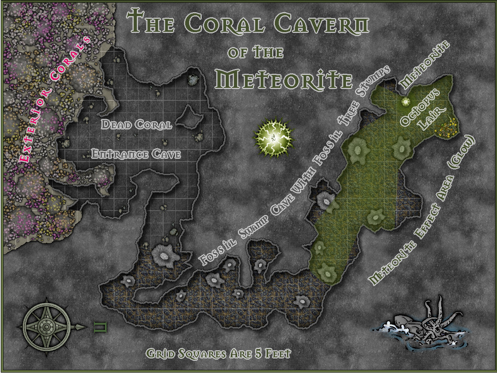
As the lair is set among the Peak Corals, it's not quite a "traditional" cave, as much of its entrance area especially has formed over time from gaps in the build-up of dead coral and other debris which has since solidified, with collapses and modifications by the more mobile creatures living on the reefs and within the cave system, along with the effects of nearby sea-bed gas escapes. Hence I decided not to use a mask to hide the outer edges of the walls here, and just let the shadow Effect from them fall where it might onto the normal Background Sheet, as a reminder the "walls" may not be really so defining as they might seem.
The inner parts of the cavern become increasingly weird. Despite being very far from land, in extremely deep water, and where the usual sea-floor rock is the typical once-molten black basalt, much of the cave floor is that of a very ancient, fossilised, swampy land surface, including numerous substantial fossil tree stumps. Once around the sharp angle, those with normal colour vision will be aware of a green light emanating from further north (north is to the right here for once). The origin of this glow is an even more ancient meteorite, embedded in the fossil swamp from when it was still a living swamp. It shines green, and is Not Entirely A Good Thing, shall we say. Its non-visual effects have led to the giant octopus that lairs here becoming tougher, longer-lived, more intelligent, and - as the substantial treasure hoard might suggest - far more acquisitive than others of its ilk. Much of its time, when not out hunting, is spent gazing contemplatively at the meteorite.
Much of the map was created from normal DD3 assets drawn over a random design from the Curufea's Random Cave Map Generator website, with a few tweaks. I did though add a couple of extras from the Mike Schley overland style - the octopus illustration and the compass rose - and labelled the whole using the Mason Serif Bold font that comes with CC3+. Before starting, I'd intended to use a lighting Effect for the meteorite's glow, but soon realised this would be impractical for the map to be useful as a GM's aid, so elected instead to use a simpler fading-glow look for the affected area, using sightlines drawn from the meteorite to establish where the "shadowed" parts of the inner cavern would be.
I added hand-sketched "tree-ring" lines to the tops of the DD3 stalagmites that were repurposed as fossil tree stumps, having already opted for the cooled lava fill texture to stand for the fossil swamp cave floor. The living coral masses outside the cave on the sea-bed were DD3 fungi and trees, including varicolor options, with added glow and transparency Effects to make them less fungal-floral. The overall look was chosen as deliberately near-greyscale and relatively dark, given the water depth here at over 750 metres (2,500 ft) is far below the depth to which sunlight can penetrate, in-keeping with my deep undersea mapping conventions, while hinting, with the limited use of colour, that things are also a little different here. And yes, naturally, the shadows are anomalous, despite being what the eye expects!
![[Deleted User]](https://secure.gravatar.com/avatar/c75d9a245b74d9c59be0999ea81ca541/?default=https%3A%2F%2Fvanillicon.com%2F92add7f8c954488718110edc4896ad39_200.png&rating=g&size=200)

-
Commission - World of Calindria
Of course, there's no guarantee the plates will be mobile (not all are on Earth, for instance), and in a fantasy setting, it might be interesting to assume they're all held locked together. Earthquakes could then happen when someone mucks about with the planet's magical field too much, threatening the stability of the whole plate structure and the entire world, say. In turn, that fixed structure might lead to lots of unusually high mountains, for instance, with volcanoes able to erupt for long periods in the same place.
However, how fixed are the plates in terms of this map? You did ask for comments regarding them, so maybe "not very"? If so, reducing the number, and making their edges fit better to the established terrain features might improve matters overall, including under the sea. Right now the edges look much too random to be believable. Obviously, if you're stuck with them as that's what your client wants, there's nothing we can do to assist with them at all!
Oh, and what's the size of the planet? Earth-like? Or smaller/larger?
With the ocean currents, are the arrow sizes intended to indicate strength as well as direction? If strength, those in the enclosed northern sea seem a bit too strong overall.
You might also want to rethink the current flows in relation to the seabed topography, and take another look at the currents towards the left edge of the map particularly. Two of the warm (red arrow) currents start abruptly very close to land for no obvious reason, and one cold (blue) one runs almost into a projecting finger of land in the north, which is very unlikely (unless there's some kind of vast "tunnel" under that finger of land that's warming the water up as it goes through, perhaps).
For the winds, it's maybe a little odd the ocean currents seemingly aren't influencing the temperature of the winds in places (again, assuming the arrow colours are temperature indicators).
