


Wyvern
Wyvern
About
- Username
- Wyvern
- Joined
- Visits
- 3,267
- Last Active
- Roles
- Member
- Points
- 5,585
- Rank
- Cartographer
- Badges
- 24
Latest Images


-
Community Atlas: Errynor - Ruined Thalassan Castle
In theory, this ruins map was going to be one of the smaller, thus quicker, maps to draw. I wanted to add it to the set from Errynor Map 01 as it was the only Thalassan (Fish-folk) structure in the area, and it seemed useful to provide at least one sample settlement for each of the represented undersea humanoid folks shown on that map.
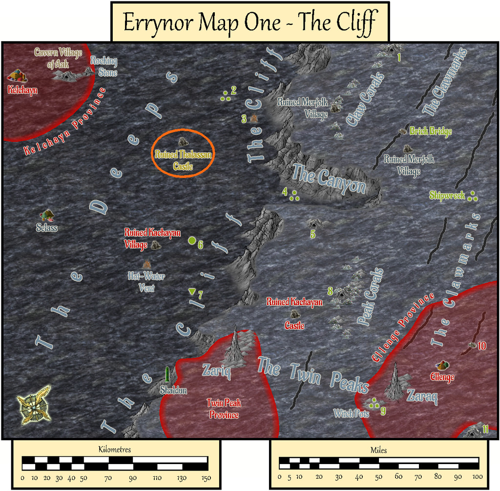
The overall pattern for it was easily established randomly from a few dice rolls, and I had already some ideas for its appearance, with whatever else might be concealed by the ruins. Given the site lies below almost 3,300 metres of ocean (nearly 11,000 feet), I wanted to use a black-and-white mapping style, in-keeping with most of the other deep-water maps in the set. It was though obvious that no style would provide the symbols I'd need for the structures, which would have to be hand-drawn. So I settled upon the Black & White Towns style by Pär Lindström from the 2015 April Cartographer's Annual, mostly because I thought the sketchy contour-line symbols in it might work well for the silt-covered rubble piles I'd envisaged as surrounding this ruin. While these did work out quite nicely, adding shading to give the rubble more definition took a lot more time than expected, particularly in showing the whole site in an elevation drawing as seen from the sea-bed.
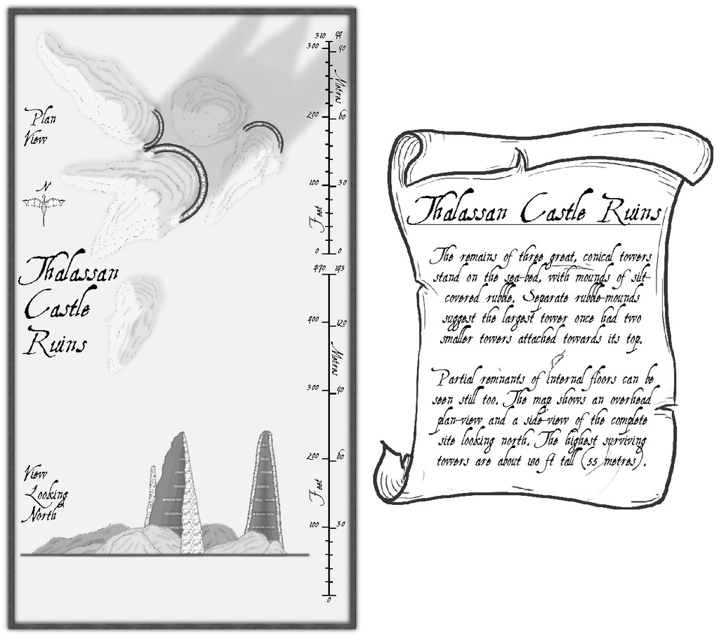
The font is AquilineTwo from the 2012 CA, as I originally thought to use the scale-bar symbol as well as the draconic north indicator from this style, and that's the font employed in these.
Clearly, there's a lot of blank space here, and the scale-lines look a little odd too. The reasons for both are explained by activating the Residual Magic toggle in the FCW file:

The explanatory banner text has also been increased here, although for clarity, those notes are repeated and expanded upon in the map's accompanying text-file and PDF notes.
As the magical blue glow extends some distance below the sea-floor surface, it's obvious there's something more happening there too, and activating the Subterranean Tunnels toggle shows what this is:
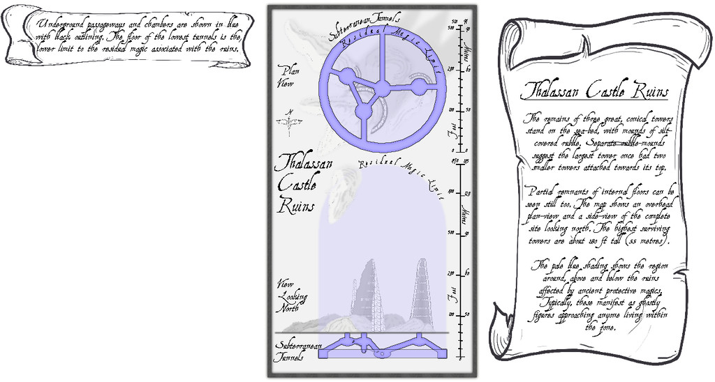
A series of subterranean chambers and tunnels, essentially, with a further banner note of explanation. The latter of course hints at still more to come, given the vast blank space beneath it. So activating the Original Towers toggle reveals...:
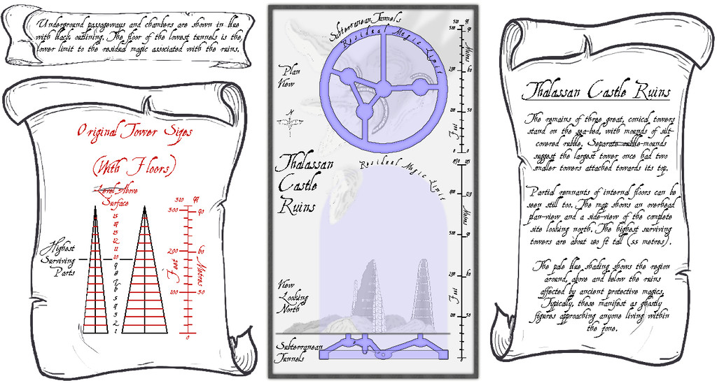
I'd had to draw out in advance what the towers would have looked like before they became ruins, to get the look, sizes and angles right, so it seemed probable this would be something other GMs might find helpful.
For the underground maps, I added a "concealer" Sheet with a Transparency Effect to reduce the strength of the surface features and magical glow for clarity, which is largely why the shadows on the surface views ended up so relatively strong, when the subterranean areas are hidden. Naturally, the shadows are unrealistic anyway, as there'd be ordinarily no light at all at such depth. Without them though, the drawings are much too flat, as some shadows at least are what the eye more or less expects.


![[Deleted User]](https://secure.gravatar.com/avatar/c75d9a245b74d9c59be0999ea81ca541/?default=https%3A%2F%2Fvanillicon.com%2F92add7f8c954488718110edc4896ad39_200.png&rating=g&size=200)


-
WIP Wel's Shamble - A small rural village
The look of this latest iteration reminds me of the map game board for the old, and long out of print, Dwarfstar Minigame Dragon Rage.
Interestingly, that game was republished by Flatlined Games about ten years ago (it's out of print again now...), and the map was redrawn for it, with a new second map on the back of the main board, using - CC3 and CD3!

-
Loopysue Hits 10,000 Posts!
Apropos of nothing much beyond my spotting this, but I see @Loopysue has just achieved the milestone of 10,000 Forum posts here today, the first person to achieve this!
Round of applause for Sue, please!
👏👏👏
😁


-
Paper Modelling (October 2021 Cartographer's Annual)
The Mapping Guide for the October issue of the Cartographer's Annual has some excellent notes on preparing and constructing paper and card models for use in tabletop gaming, aside from describing the models provided with this issue and how to customise them for individual use.
Two paper model manufacturers were singled-out for particular attention there, World Works Games and Fat Dragon Games. Both have indeed been producers of excellent quality downloadable PDF models, and both have construction information provided with some of their products and separately online. However, there's an unfortunate past tense here.
Fat Dragon Games is still a going concern, but the owner has switched attention entirely to 3D printed models in the last few years, so while the paper models back-catalogue remains fully available, there have been no fresh models during that time, nor does it seem likely now that there will be. Fat Dragon's products are available directly from the company's website, as well as via the OneBookShelf download sites (such as DriveThru RPG).
World Works Games too still have much of their old back catalogue available online, but only via their own website. For unclear reasons, the owner stopped supporting the site some years back, and has produced no new models in many years. In recent times, the website has been offline with monotonous, if unpredictable, frequency. While their paid-for models have all been permanently reduced in price now, this problematic access to the site (which also restricts you to a limited number of downloads for each item purchased) means that if any of their models do appeal, be sure to make plenty of backup copies of anything you buy and download from them.
As someone who's spent a lifetime making and designing paper and card models, my recommendation would be to check around for paper models and miniatures via the OneBookShelf sites (some manufacturers are not on both DTRPG and Wargame Vault, for instance), but perhaps more usefully, to also check-out, and spend some time looking through, the copious amounts of information freely available on the ProBoards Cardboard Warriors Forum. That Forum provides access to vast numbers of free minis and models (often via the One Monk Miniatures website), with links to many more stored elsewhere (including via the Internet Archive, for those items no longer on active websites), while many of the currently-active paper mini and model producers are often present there. You don't have to be a ProBoards member to access the Forum (free to join, and no real obligation beyond the usual Forum politeness, much as here), but if you want to post there, such as to ask questions (there's always someone happy to try to help, if possible), you will need a ProBoards account. You may even notice a curiously familiar moniker among the contributors there...
Just wanted to say too it was nice to see Dioramas 3 getting a little love via this Annual issue!
-
How to remove white line on smooth polygon river; Herwin Wielink Style
There are learning curves with most of the mapping styles, I've found - remembering what symbols and drawing tool fills are available in each, particularly - and it does help if you're working with one, or a few together (as here), for some time. I like the Herwin Wielink style as well; it was the primary alternative to what was just CC3 when I started working with the program, and I made plenty of mistakes trying to recreate a map of part of the D&D Sword Coast region of their Forgotten Realms setting for 5e using it.
This latest shot is very impressive of your own map!

