


Wyvern
Wyvern
About
- Username
- Wyvern
- Joined
- Visits
- 3,266
- Last Active
- Roles
- Member
- Points
- 5,584
- Rank
- Cartographer
- Badges
- 24
Latest Images


-
Community Atlas: Errynor - Aunty MacKassa's Home & Vehicles
And so to the vehicles. The first of these, the wrecked ship, proved by far the most time-consuming in this Aunty MacKassa set. I'd selected the Sailing Ships pack from the 2009 Cartographer's Annual, which as noted previously, provides only limited help for drawing pre-gunpowder-period vessels, especially as I prepared these illustrations some time before the Annual was updated in April 2021.
My design for what became "The Naughty Lass" (it can sail beneath the waves and on the surface, after all!) was decided following heavy influence from Pauline Baynes' drawings of "The Dawn Treader" in C. S. Lewis' novel of its voyage, along with the nicely-detailed "Sea Ghost" ship drawings in the D&D scenario book "Ghosts of Saltmarsh" (2019, p. 53). This led ultimately to this deck plans map:
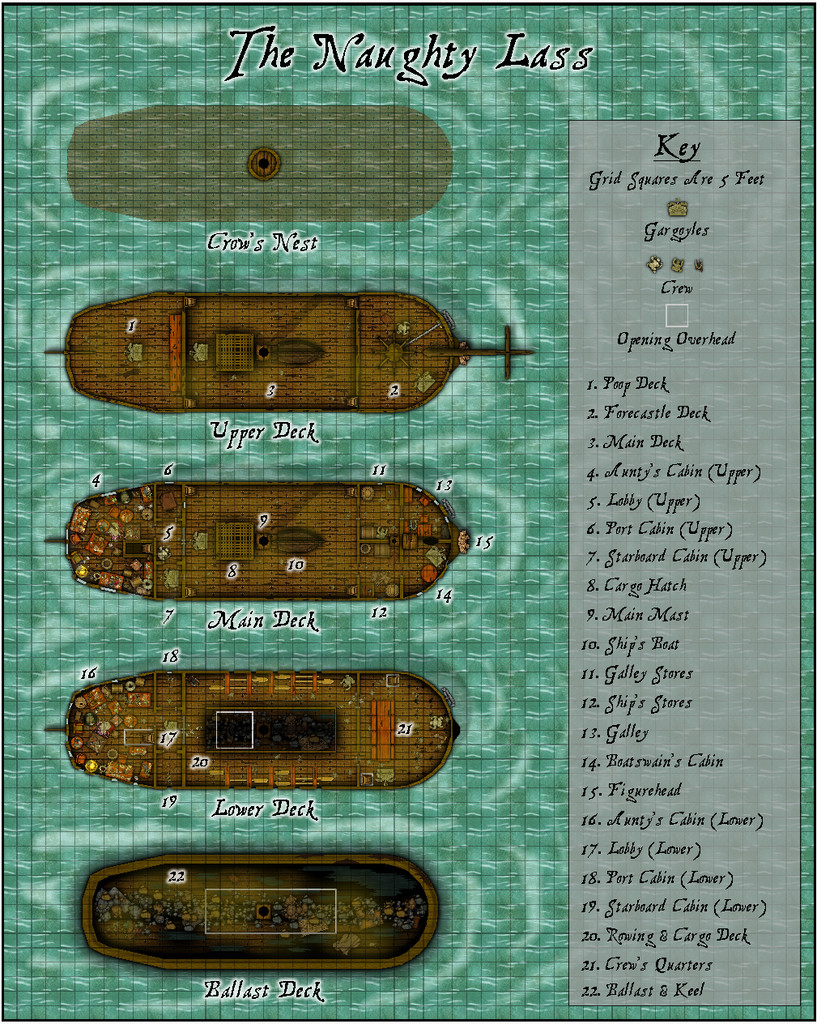
I got into rather a mess with this, however, as my initial idea had been to have one vertically-narrow rectangular plan view with the individual decks being toggled on and off one at a time within that condensed space using the map's Layers. Unfortunately, this ran into problems due to interference between the Sheet Effects in the lengthening stack of Sheets per deck, and between decks. So the deck plans had to be separated out, and the map greatly expanded, into the form now shown here. The Layers though ended up partly in the very condensed form as originally envisaged, partly in a more standard format for the decks I'd constructed later in the process. The Sailing Ships pack was meant to show just one deck per map, but that had seemed a little too clumsy for what will be really just a minor adjunct to another map once entered into the Community Atlas. I'd definitely draw the map differently as far as the Layers are concerned, if starting again now. At least it looks more or less OK still, I hope!
From the beginning, I'd also wanted to do a vertical section for The Naughty Lass, as that option is part of the Sailing Ships set-up. So I did, complete with "ghost ship" glow:
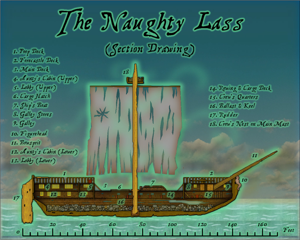
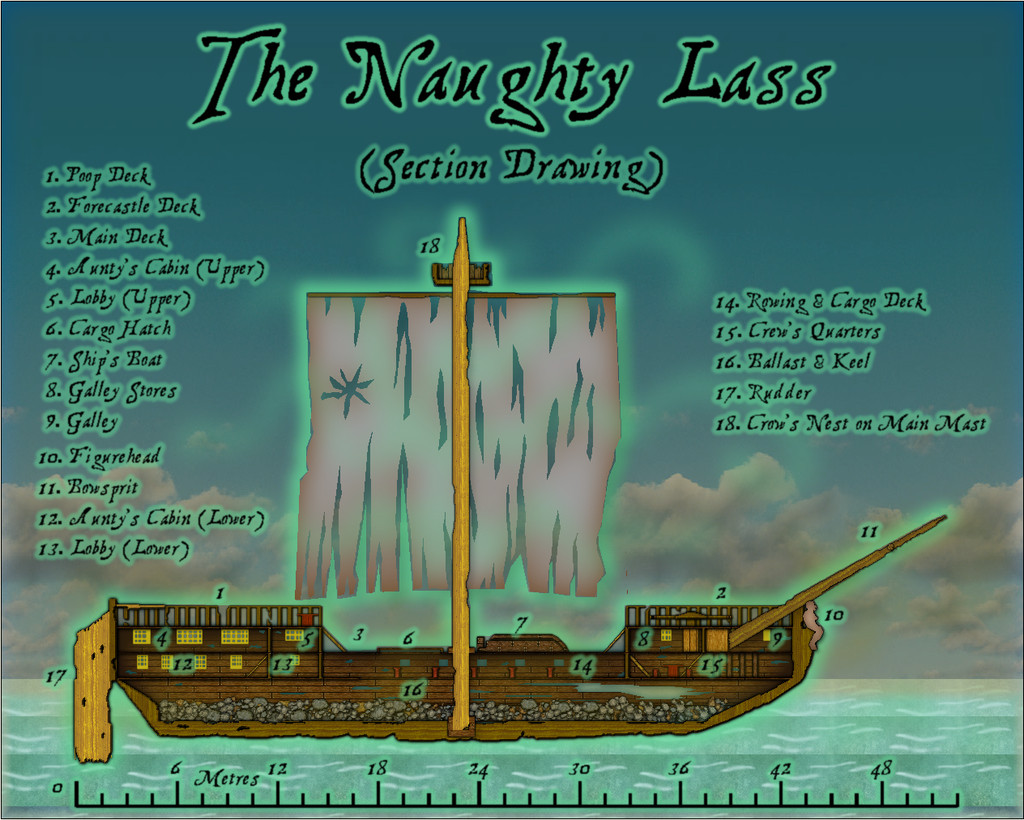
And an optional metric scalebar, via an Atlas toggle in the FCW file:
I also had to tone-down the original daytime-bright sky backdrop, to something more dismally matching Aunty's nature.
Again, a PDF and text-file set of notes will accompany both these drawings, in which you can find out about the nature of the ship's "adults-only" figurehead and how it relates - in Aunty's idea of dark humour, naturally - to the vessel's name...
For the Atlas, the Section Drawing is linked from the Coral Cave map via the "ghost ship" symbol in the top right corner, with the Deck Plans map connected from the Section Drawing only.


![[Deleted User]](https://secure.gravatar.com/avatar/c75d9a245b74d9c59be0999ea81ca541/?default=https%3A%2F%2Fvanillicon.com%2F92add7f8c954488718110edc4896ad39_200.png&rating=g&size=200)

-
Community Atlas: Errynor - Aunty MacKassa's Home & Vehicles
Resuming the presentation of the final maps linked to Errynor Map 01 from previously, all concerning the deep-sea hag Aunty MacKassa, we must now zoom right in to Aunty's deep-sea-bed home:
From early in the process of constructing Aunty's lair, I wanted both a fixed-spot home cave, and at least one unusual vehicle, to let her get out and about in "her" 50-mile zone, as established earlier, more readily. This is what some hags have in real-world folklore after all, such as Baba Yaga's chicken-legged hut and flying mortar and pestle. I settled on two smaller "spare" random cave designs from what I'd downloaded from the Curufea's Random Cave Map Generator website earlier as suitable for her coral cavern lair, providing a pair of subterranean levels. These were chosen mostly because each had one cave of a form roughly like the stern of a ship, and a shipwrecked vessel seemed the most obvious choice for a deep-sea hag's vehicle. My idea was, being a faerie creature, and thus seemingly able to circumvent physical "laws" most folks take for granted as "normal", that Aunty would be able to shift her lair effortlessly between cave and vehicle whenever she chose, so a similar shape and size for at least part of both seemed reasonable. Then an idea for a second vehicle, suitable for amphibious sea to land transport, came about too, from which the clearest option was a hut made from another shipwreck, with - what else? - gigantic crab legs.
As I knew elements would need to be copied between all three of these maps, I decided to use the standard DD3 mapping package, except for the fonts. The Coral Cave map was done first (using the East Anglia font from the 2012 Cartographer's Annual):
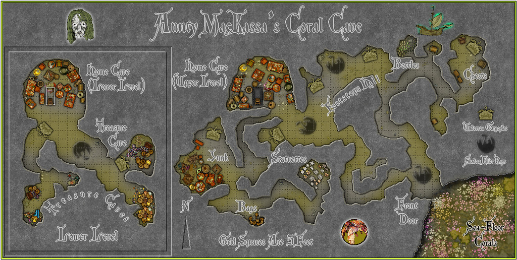
The hatch and ladder between the levels of the Home Cave were chosen to fit with the ship's-cabin concept, of course, while the scatter of clutter and treasure (if it is) was distributed as a compromise between the classic D&D very cluttered hag's lair, and a map that could be read still. Although the deep-sea hag creature is largely an idea of my own of old, it has always been heavily influenced by D&D, and as the 5th edition allows powerful hags to have an assortment of servants, I came up with the illustrated variants of Undersea Gargoyles and Shadow Killer Rays here (the latter drawing partly on a 1953 short story by Joseph Payne Brennan, "Slime", which made a lasting impact on me when I first read it as a youngster). The illustrations for the latter, the north pointer, and the "sunken" border around the Lower Level map segment, were enhanced thanks to the chance publication of Remy Monsen's blog posting on the use of Bevel Effects to create sunken "carvings" on floors while I was preparing this map.
Then I thought it would be interesting to see just what Aunty MacKassa looked like. So I constructed this image of her, using CA3:
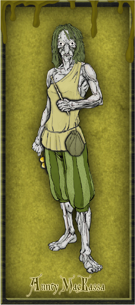
As usual, there'll be a PDF and series of text-file notes available in the Atlas to explain the game-relevant map details, from which you can discover why she has a long, bone hairpin in her grasp, and a pair of gold-tinted spectacles in her other hand, should you wish! Plus of course, I added her face to the Coral Cave map to serve as the Atlas link-point to this portrait.


-
Community Atlas: Errynor - Aunty MacKassa, the Area Maps
Thanks @Monsen !
-
Community Atlas: Errynor - Aunty MacKassa, the Area Maps
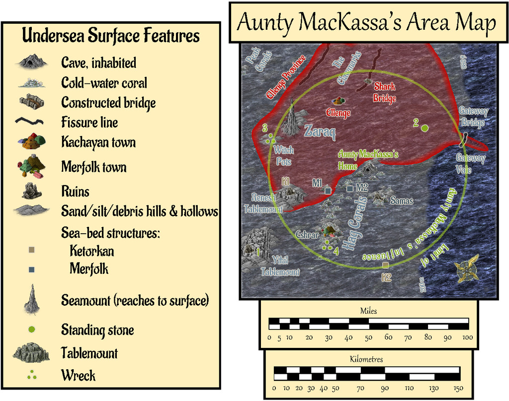
The set of Aunty MacKassa maps is the final group in the series of sub-maps from Map 01 of my Errynor mapping project. I'm not intending anything quite so extensive for the other 39 250 x 200 mile maps in the set, though you never know! Indeed this group of drawings grew rather out of hand anyway, albeit I've long found RPG scenario planning has a tendency to do that as the ideas build up along the way. My original intentions for three maps to detail deep-sea hag Aunty MacKassa's lair (site 11 in the lower right corner of Map 01) have ended-up as seven separate drawings!
Partly, this was because while working on some of the other detail maps in that corner of Map 01, I'd realised Aunty MacKassa could have been long-influencing events elsewhere across the region, especially at the Kachayan settlements of Shark Bridge and Ellenge. Aunty's backstory in all this is given among the various map notes with this set, incidentally.
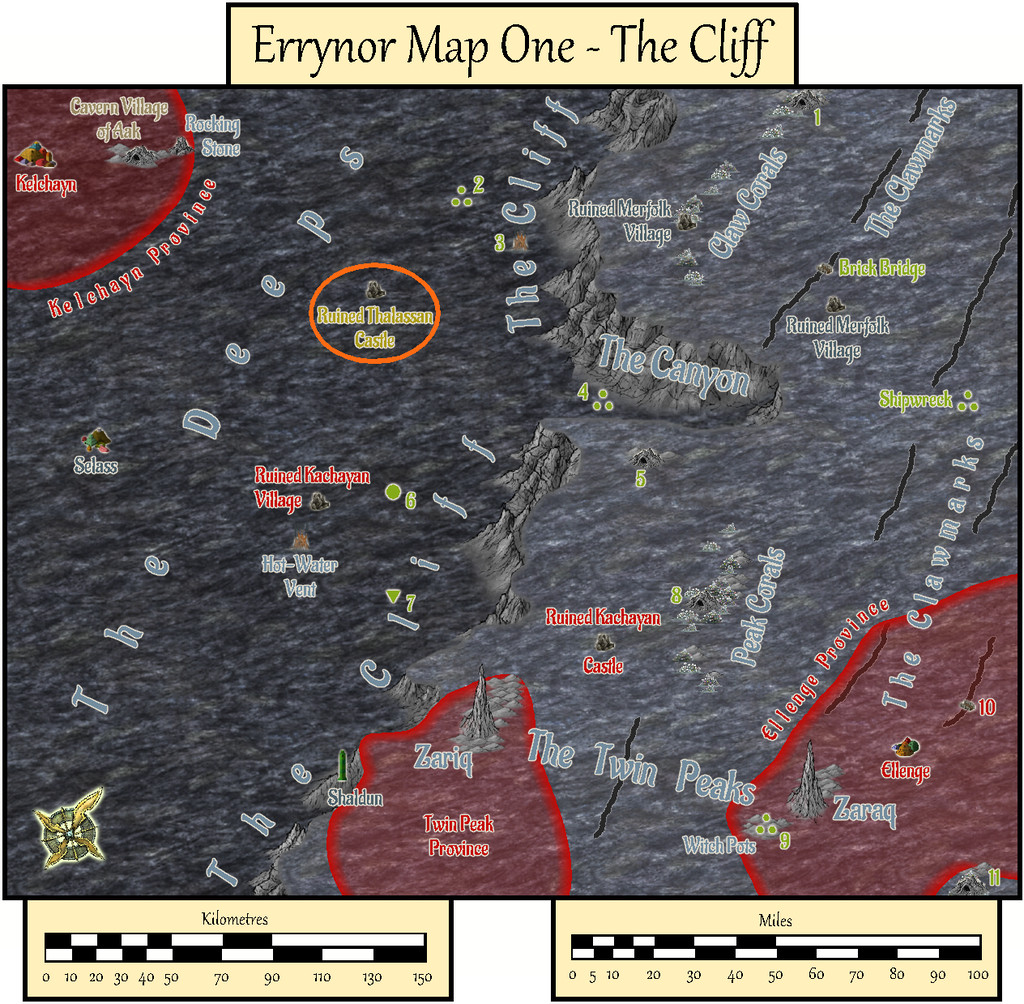
As Shark Bridge is almost 50 miles from Aunty's coral cave lair, I decided to set a 50-mile radius limit to her influence overall, a zone where she might sometimes be seen, and within which she might wish sometimes to act. This had the further possibility to reduce the edge-of-the-world syndrome of Errynor Map 01, because this zone spans parts of Maps 01, 02, 09 and 10. Of which only Map 01 has so far been completed, of course:
Thus came about the first Area Map, in three versions, following the standard pattern established by Map 01, for the sea-bed, water column, and sea-surface views, using the Herwin Wielink mapping style:
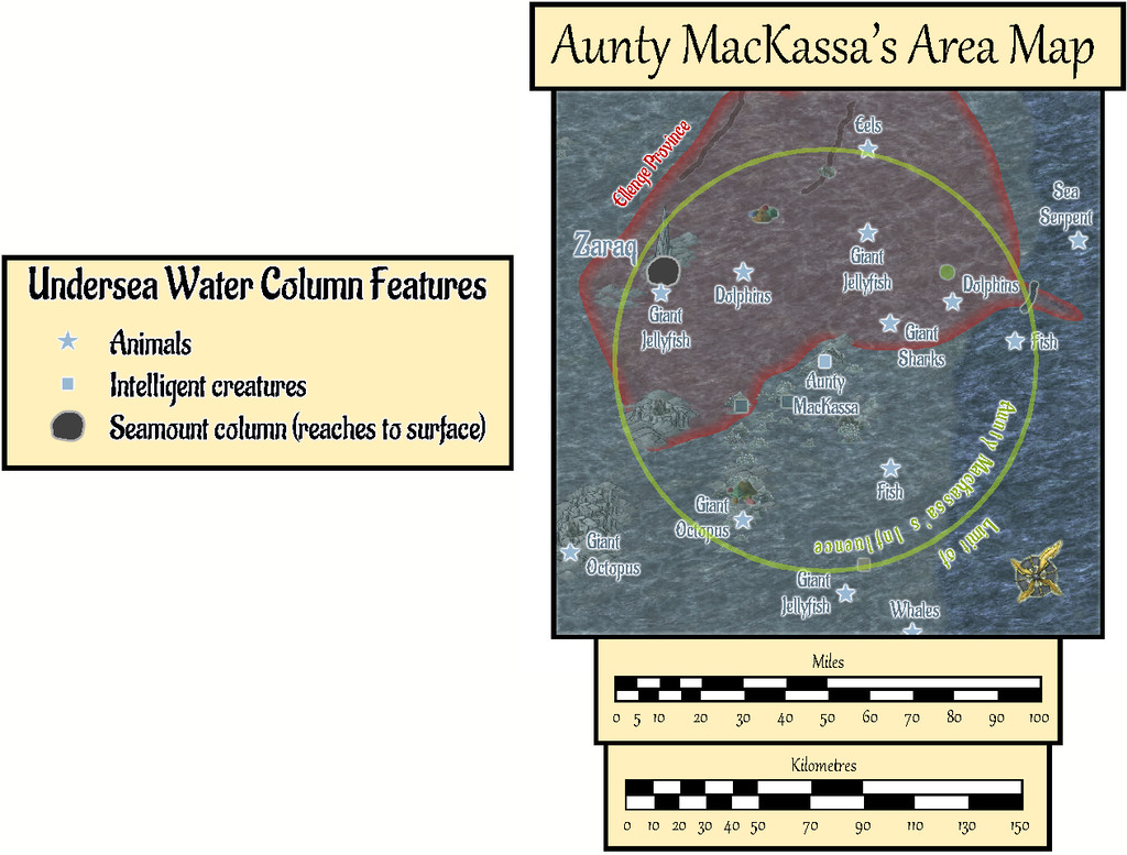
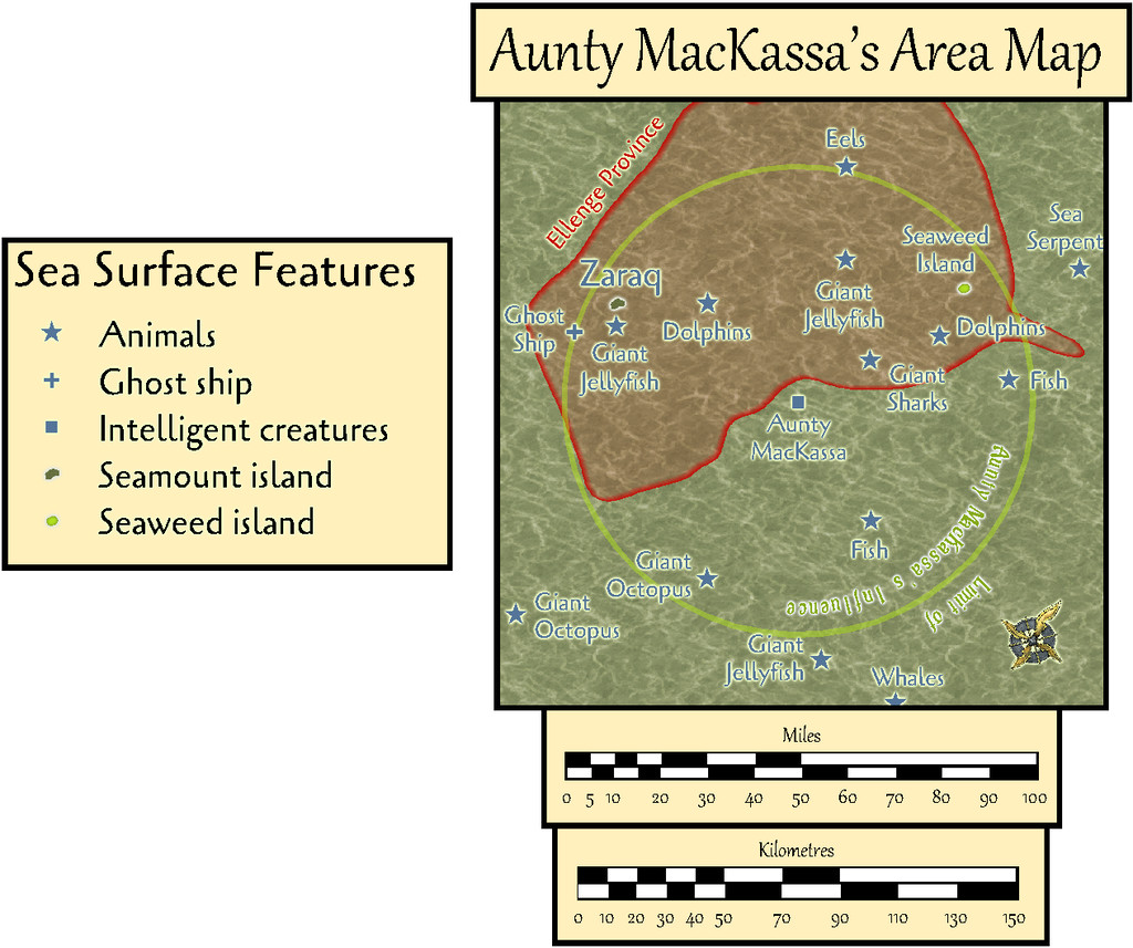
Fresh PDF and text notes were prepared to accompany this map.
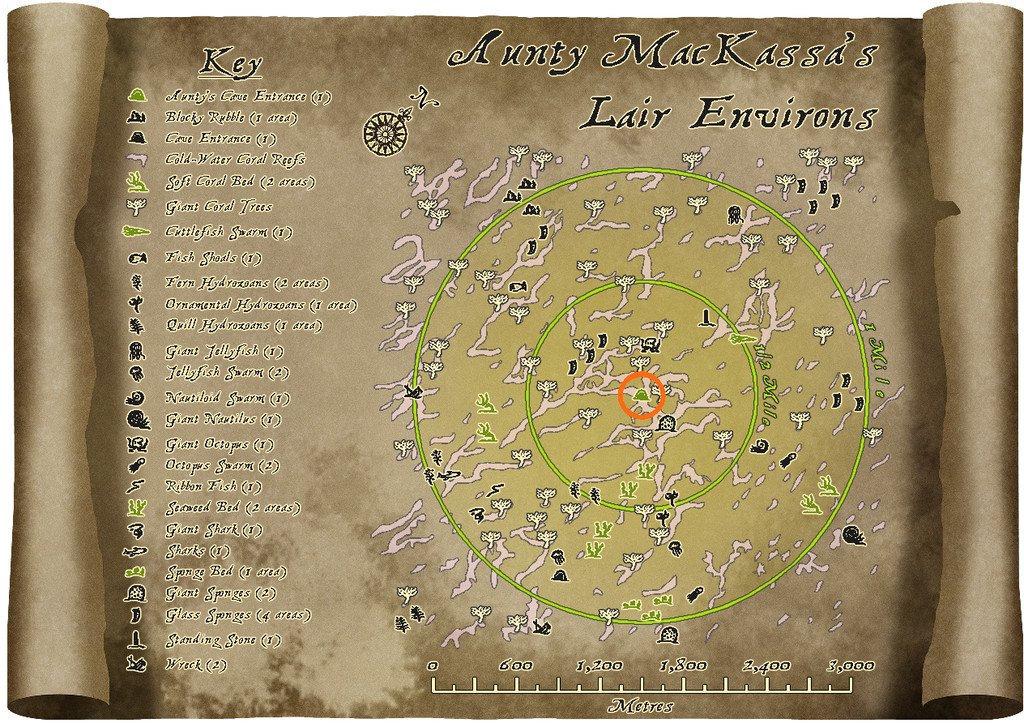
Next, I began zeroing-in on just Aunty's lair:
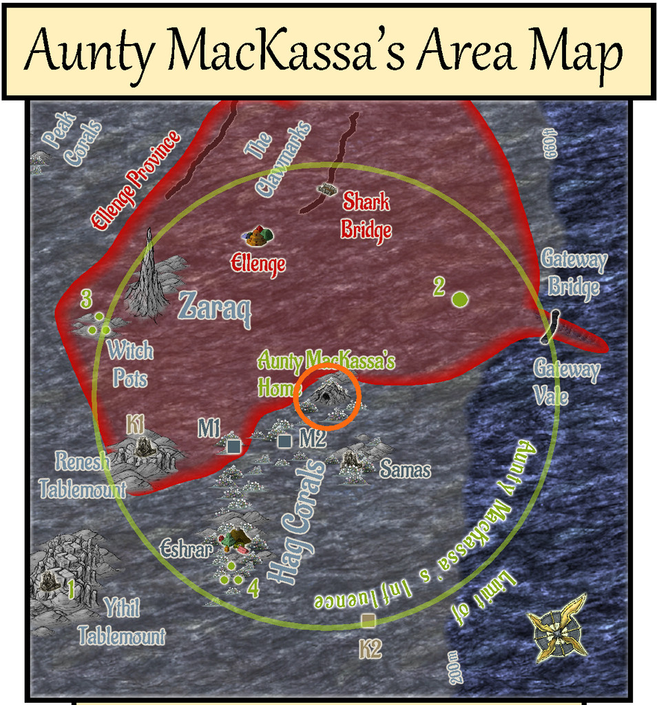
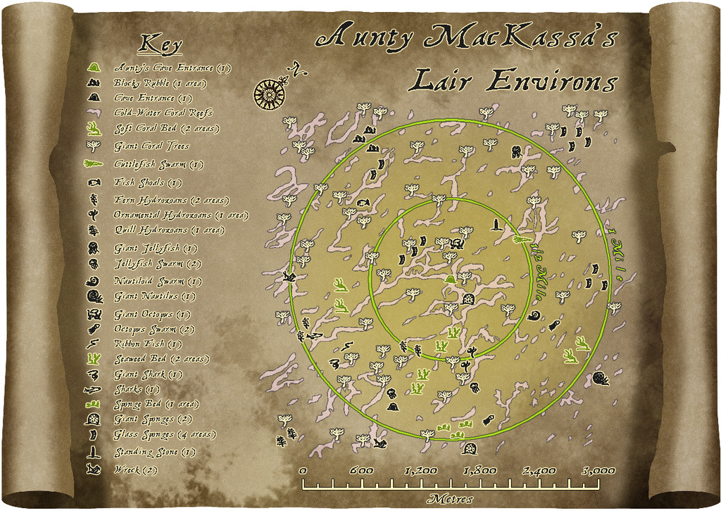
The next map shows in detail the sea-bed region a little over a mile in extent all around Aunty's Cave home. I'd rather enjoyed drawing the Shark Bridge area map earlier, using a different background and simple vector not-symbols (they're just copied small drawings, not true CC3+ symbols), so opted for a variant on that, choosing one of Sue's Parchments from CA132A for this map's backdrop, and sketching-in the cold-water coral reefs, with the local wildlife and other surface features, all of which had been previously randomly-rolled in preparation. The "symbol"-drawings were much-expanded from the collection used in the Shark Bridge map, naturally:
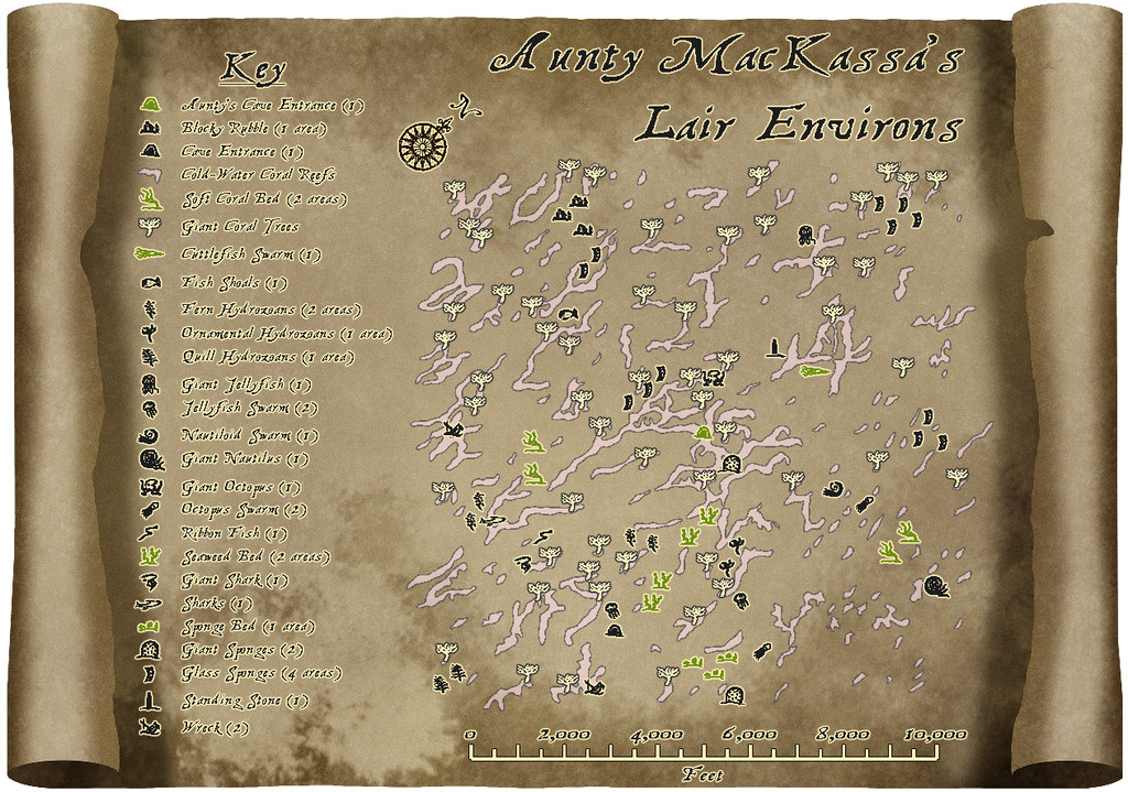

The second version allows the zones closest to Aunty's lair to be precisely identified for GMs, using toggled circle overlays. The nature of the features themselves is detailed in a further set of PDF and text-files notes accompanying this map.
There wasn't space to add a metric scalebar too, so that's been provided as an option via toggle for the Atlas FCW version:
The remaining five drawings in this set should follow shortly, all being well!


-
Community Atlas: Errynor - Ruined Thalassan Castle
In theory, this ruins map was going to be one of the smaller, thus quicker, maps to draw. I wanted to add it to the set from Errynor Map 01 as it was the only Thalassan (Fish-folk) structure in the area, and it seemed useful to provide at least one sample settlement for each of the represented undersea humanoid folks shown on that map.
The overall pattern for it was easily established randomly from a few dice rolls, and I had already some ideas for its appearance, with whatever else might be concealed by the ruins. Given the site lies below almost 3,300 metres of ocean (nearly 11,000 feet), I wanted to use a black-and-white mapping style, in-keeping with most of the other deep-water maps in the set. It was though obvious that no style would provide the symbols I'd need for the structures, which would have to be hand-drawn. So I settled upon the Black & White Towns style by Pär Lindström from the 2015 April Cartographer's Annual, mostly because I thought the sketchy contour-line symbols in it might work well for the silt-covered rubble piles I'd envisaged as surrounding this ruin. While these did work out quite nicely, adding shading to give the rubble more definition took a lot more time than expected, particularly in showing the whole site in an elevation drawing as seen from the sea-bed.
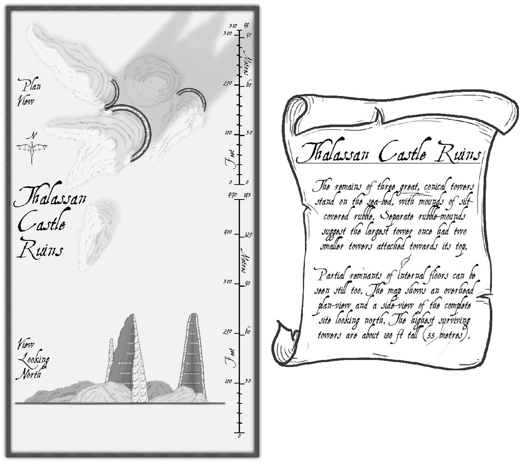
The font is AquilineTwo from the 2012 CA, as I originally thought to use the scale-bar symbol as well as the draconic north indicator from this style, and that's the font employed in these.
Clearly, there's a lot of blank space here, and the scale-lines look a little odd too. The reasons for both are explained by activating the Residual Magic toggle in the FCW file:

The explanatory banner text has also been increased here, although for clarity, those notes are repeated and expanded upon in the map's accompanying text-file and PDF notes.
As the magical blue glow extends some distance below the sea-floor surface, it's obvious there's something more happening there too, and activating the Subterranean Tunnels toggle shows what this is:
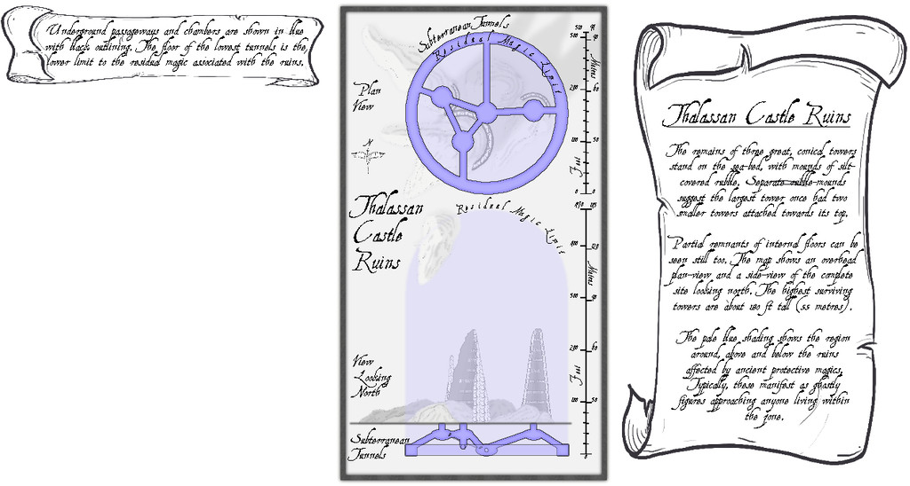
A series of subterranean chambers and tunnels, essentially, with a further banner note of explanation. The latter of course hints at still more to come, given the vast blank space beneath it. So activating the Original Towers toggle reveals...:
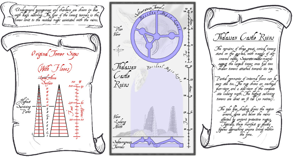
I'd had to draw out in advance what the towers would have looked like before they became ruins, to get the look, sizes and angles right, so it seemed probable this would be something other GMs might find helpful.
For the underground maps, I added a "concealer" Sheet with a Transparency Effect to reduce the strength of the surface features and magical glow for clarity, which is largely why the shadows on the surface views ended up so relatively strong, when the subterranean areas are hidden. Naturally, the shadows are unrealistic anyway, as there'd be ordinarily no light at all at such depth. Without them though, the drawings are much too flat, as some shadows at least are what the eye more or less expects.


