


Royal Scribe
Royal Scribe
About
- Username
- Royal Scribe
- Joined
- Visits
- 9,950
- Last Active
- Roles
- Member
- Points
- 3,488
- Birthday
- February 5, 1968
- Location
- San Francisco, California
- Website
- https://legacy.drivethrurpg.com/browse/pub/31814/Royal-Scribe-Imaginarium
- Real Name
- Kevin
- Rank
- Mapmaker
- Badges
- 16
Latest Images

Reactions
-
Chotlan - Meso American little town
Love the use of magic on the temple and the flames at the arena

-
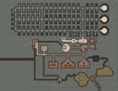
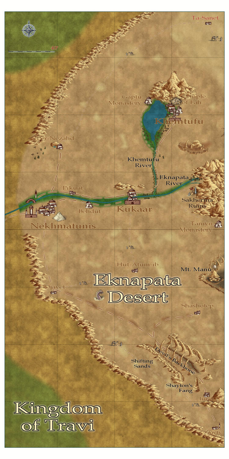
[WIP] Community Atlas - Eknapata Desert
Thank you! Here's how it looks with the effects changes. And I've standardized the font sizes to three: 10 points for country names, 5 points for the three major cities, and 3.5 pts for everything else.

-
Community Atlas submissions: the Gold Coast (Doriant) and areas within it
I'm ready to submit this intermediate map for the Kingdom of Enía, along the northern edge of the coast for the parent map above. This map will be the parent (or possibly grandparent) for a few villages I will be submitting to the contest.
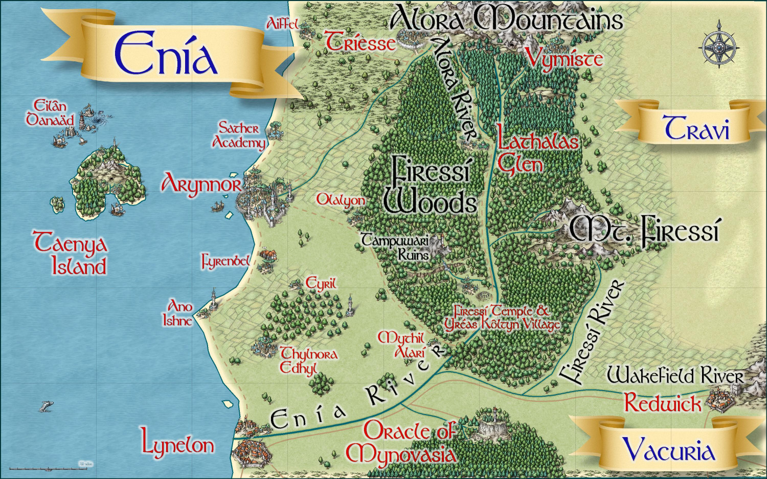
Primary Style: Mike Schley Overland
Toggles: BORDERS/POLITICAL to show/hide political borders
Here is the FCW along with a PDF of the description:
Should I do a plain text file that strips out the accent marks? Here's the text of the description (with accent marks):
The elven kingdom of Enía is the northernmost coastal kingdom in the Gold Coast region of Dórian. The human Kingdoms of Vacuria and Travi lie to the south and east, respectively. Enía is significantly smaller in both population and geographic size than its neighboring kingdoms. The kingdom’s borders are marked by the Enía River along its southern border, and the Firessí River and edge of the Firessí Woods along its eastern border.
Enía is governed by a hereditary monarch who is advised by two political bodies: the Council of Adept Mages, and the People’s Assembly. The Council of Adepts consists of those archmages and adept mages able to cast the most powerful spells. The People’s Assembly includes a hundred citizens elected throughout the realm.
Major points of interest include:
Arynnor: The capital of Enía, called the “city of glass.” Here, elves pioneered glassblowing techniques both for ornamentation and practical purposes. This includes a technique to make glass nearly as strong as steel, which has allowed the elves to safely cover their towers with brightly colored glass domes.
Sather Academy: To the north of Arynnor, Sather Academy is an institution of higher learning with academic classes of all sorts, from history to astronomy, poetry to accounting, but it is most famous for two things: its Bardic Colleges, and its Arcane Academy for the formalized study of wizardry and arcane lore.
Lynelon: The coastal city on the northern bank of the Enía River, Lynelon is a bit smaller than the Vacurian city of the same name on the southern bank.
Firessí Woods: Much of the realm is covered by a mighty forest, the Firessí Woods. The woods are home to numerous tiny elven hamlets along with a few notable features. Towards the southern edges of the Firessí Forest lies an ancient henge of standing stones, the Firessí Temple, erected to honor the elven gods. It is the holiest place in all of Enía, and the seat of power for the Archdruid of Firessí, the most powerful religious figure in the kingdom. A small village, Yréas Kôltyn, provides a home for the elves who tend to the temple and provides accommodations for the temple’s many pilgrims. To the northwest of the temple lies the Tampuwari Ruins, the haunted ruins of a people so ancient, they disappeared long before the elves moved to the area. The ruins are best to be avoided. Farther to the north, Lathalas Glen is a town built up around a monastery of the same name.
Taenya Island: The small island is home to a few small villages and hamlets of wood elves Just to the north of the island among rocky reefs, Eilân Danaäd is a harbor village of sea elves with homes both above and below the waves.

-
[WIP] Atlas Contest: Eilân Danaäd (Sea Elf Village)
After doing a dark elf farming village and a wood elf forest treehouse village, how could I resist revisiting my sea elf outpost and using it as inspiration for a sea elf village?
This is Eilân Danaäd, a harbor and village in a rocky reef area north of an island off the coast of Dóriant. The village includes both dry ground structures on the harbor side as well as below-water residences on the other side. The sea elves created the harbor as an opportunity to trade with sailors from the Dóriant mainland, as well as sailors traveling to Dóriant. The elves sell or trade deep sea fish and marine vegetation that would be difficult or impossible for surface-dwellers to get to. They also provide ship repair services for ships damaged at sea, and help sailors navigate through the rocky reefs.
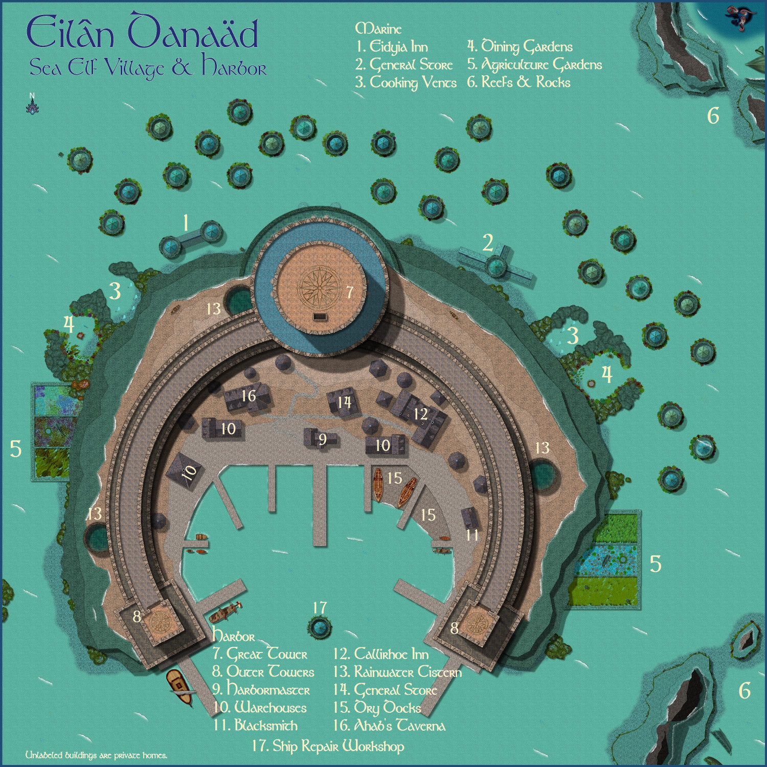
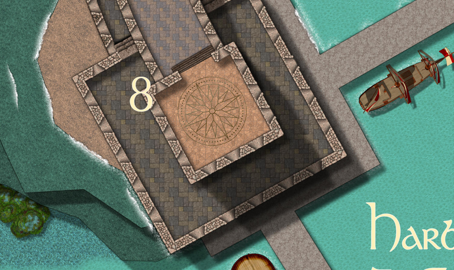
The harbor consists of a horse-shoe shaped tiered great wall, with a great tower in the center and two somewhat shorter outer towers. Each tower has a landing pad on top to accommodate aerial visitors who ride pegasi, griffons, or other flying mounts.
The Great Tower in the center extends all the way down to the sea bed. It contains the villages government, and has plenty of space both below and above the surface of the water for the sea elves to hunker down during the strongest storms. (The sea elves wouldn't drown in the storms, but they could be blown miles out to sea.)
The harbor includes an inn for sailors eager for a bit of dry land and a bed that doesn't rock. It also includes a tavern, where sea elves can imbibe with visiting sailors. (Drinking alcohol -- or any other liquids -- isn't possible below the waves, though in their marine environment, the sea elves do imbibe with hallucinogenic fungi, fermented sea cucumbers, and other intoxicants.)
There is no natural source of fresh water at the harbor, so the elves have created several cisterns to capture rainwater. Sprinkles of rain occur nearly daily, and storms (usually mild) occur frequently throughout the year.
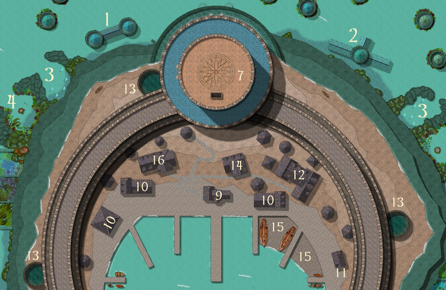
Both the towers and the wall are in two tiers, with the lower tier rising about 50 feet above sea level and the upper tier another 30 feet above that. The wall provides protection for the above-ground part of the village for all but the strongest of storms.
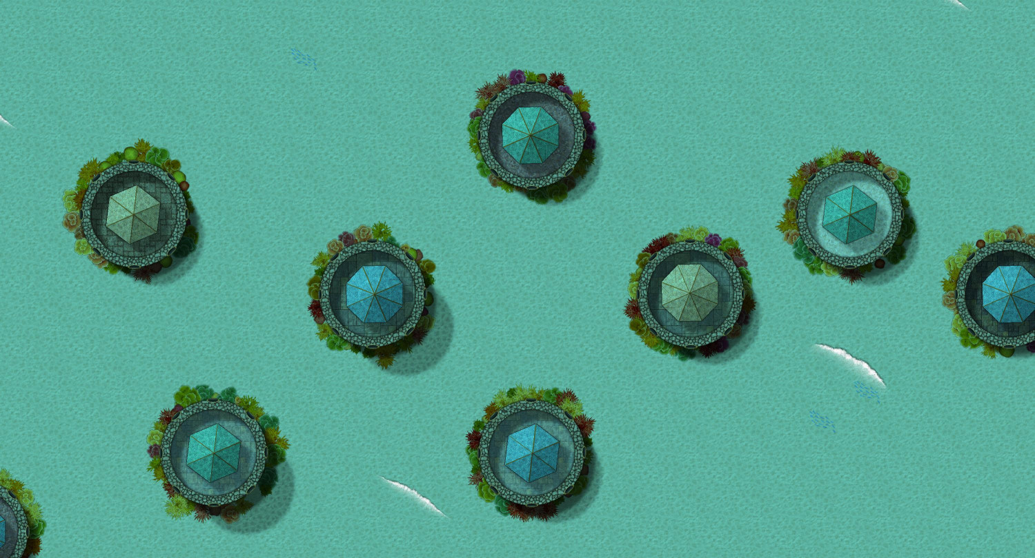
Below the waves, most of the village residents live in private homes topped by either a hexagonal or octagonal turret. Each residence is either one, two, or three stories high, not including the turret. (Note the shadows of different lengths.) The entrance to each residence is through a doorway at the turrets. There's no need to swim all the way down to the seabed to disturb the coral gardens surrounding each residence, as the entrances are at the top.
The one-story residences are basically studio cottages, with sleeping and living spaces all at one level. The taller residences will have a common area off of the turret's entrance, with bedrooms in the levels below.
None of the residences have cooking facilities. Dining at home requires food that can be eaten raw, or previously-cooked food that can be served cold. Instead, cooking is done at common cooking spaces (#3), where residents bring food on long skewers to cook over geothermal sea vents. The cooked food can then be brought back home, or can be brought to one of the dining commons (#4) for a picnic.
The sea elves do have a few marine agricultural gardens. Each of these has a pillar in the middle, where gardeners can activate an enchantment that helps keep pests away. The enchantment creates the illusion of a shark swimming around the area. The illusory shark radiates a low-grade Fear spell. Elves are immune to the spell, and it's low grade enough that most intelligent creatures only experience a mild feeling of foreboding at best. But for fish and other low-intelligent sea creatures, the spell triggers a flight reflex, which helps the elves keep their crops from being nibbled away by marine pests and predators.
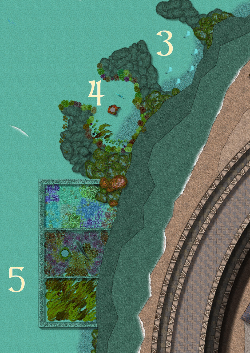
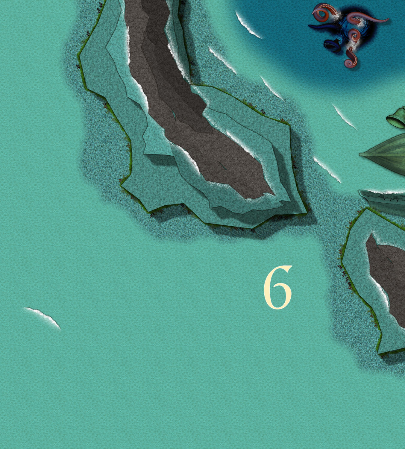
Farther away from the harbor, I created a few examples of the rocks and reefs. I tried a different approach to creating them. Instead of using polygons with a sharp bevel, I instead used several polygons with a "Shaded Polygon (Angled by Edge") effect, each with different angled slops. Let me know if you think I pulled it off.
Some sort of tentacled sea creature has taken up home near one of the reefs. The sea elves can help sailors navigate around it to avoid a Scylla v. Charybdis catastrophe.


-
Ideas for future Annuals
In a previous thread, Ralf encouraged us to post ideas for future annuals and artists we’d like to see. I know there’s been threads of these sorts of ideas before, but I thought I would take the opportunity to start a new thread, and I hope folks will add their own thoughts.
There’s this one artist whose style I really love. She’s super busy right now, but if she ever has a spare moment, I always love new additions from … Sue Daniel! ;-)
This month’s annual highlighting Mike Schley’s Overland symbols really emphasizes how much of his stuff we have to work with – not just overland, but city and dungeon, too. Since he’s been a longtime D&D designer, his style is great at capturing the same vibe when designing your own maps for D&D campaigns. In deciding what style I want to use for a new map, I often gravitate to his because of how much variety there is to work with. (If he’s looking for city and dungeon level ideas, I would love more Greco-Roman buildings and furnishings.)
So in that spirit, I would love to see more annuals with stuff that is compatible with other styles, particularly Darklands City and Spectrum Overland. I know that might be tricky to do an expansion of an annual released years ago. When an annual has an expansion, it’s generally in the same year (Marine Dungeons, Darklands City, Forest Trail, Monkey Frog Overland, etc.) so that a customer doesn’t have to buy two annuals to use both sets together. But what about expansions designed to stand on their own but also work complimentarily with previous sets? I’d love to see more settlement and adventure-hook symbols that are compatible with Spectrum Overland, and more structures/buildings for Darklands City (and the snowy versions for Winter Village). Right now I’m on an elves & dwarves kick, so elven/dwarven Darklands City structures would be awesome.
Other ideas:
Jungle/Swamp Adventures: something compatible with Creepy Crypts & Forest Trails, but with more jungle elements – palm trees, tropical trees, swamp trees (like trees in water with the ripple effects from Marine Dungeons), bright flowers and other foliage, monster/beast footprints, vines, traps, treasurers you might find adventuring in ruined temples.
Castle Construction: something like CA149 Beaumaris Castle, but with design tools and more castle-specific symbols. Symbols like gargoyles, varicolor flags & banners, crenellations (like the way Marine Dungeons lets you drop crenellations onto walls), machicolations/murder holes, plate armor, thrones, weapons, murder holes, siege/warfare equipment…
Inlays: I’ve mentioned this before, but I would also love more varicolor vector symbols that could be used for so many things like heraldic charges, floor inlays, stitching on fabric (rugs, banners, etc.) – animals, weapons, flowers, runes (in dwarven and elven styles), Celtic or elven design patterns, astrology and astronomy symbols, etc.


