


roflo1
roflo1
About
- Username
- roflo1
- Joined
- Visits
- 2,878
- Last Active
- Roles
- Member
- Points
- 576
- Rank
- Surveyor
- Badges
- 8
Latest Images
Reactions
-
Cartographer's Annual 2023 broken zip
Same thing happened to me a couple of months ago, also on Linux. I contacted support, but then managed to fix it before Ralf could respond.
My log says I fixed it by using
zipfix.And for the record, and in case someone searches for this in the future, the message I got from the command-line zip utility (the GUI tools weren't as specific) was:
Archive: CA2023_Setup.zip
warning [CA2023_Setup.zip]: 869314210 extra bytes at beginning or within zipfile
(attempting to process anyway)
error [CA2023_Setup.zip]: start of central directory not found;
zipfile corrupt.
-
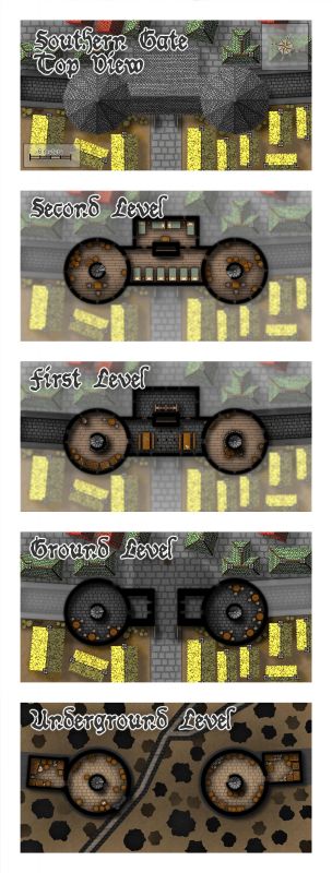
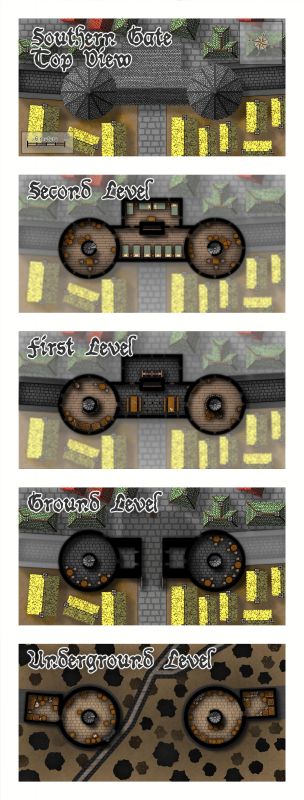
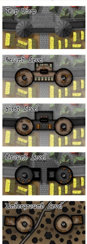
[WIP] August Competition - The Southern Gatehouse
I wonder if I can insert an image from my gallery, so it can be displayed in a better resolution...


-
Deepzoom images for web display
And then share it with us? ;)

-
Filling unneded space
Unless I'm misunderstanding your issue...
... you should be able to place a filled polygon with your desired texture there.
-
Does Size Ratio Matter or Absolute Size?
Oh man... just yesterday I read Remy's article "Scale Matters" in the World Builder's Compendium.
If you own it (it's included in the ongoing Humble bundle) it's very much worth reading!

-
Trying out a Planescape style
I made a mess. Please learn from my mistakes. ;)
Next up in line came the gate-town Hopeless (see original map).
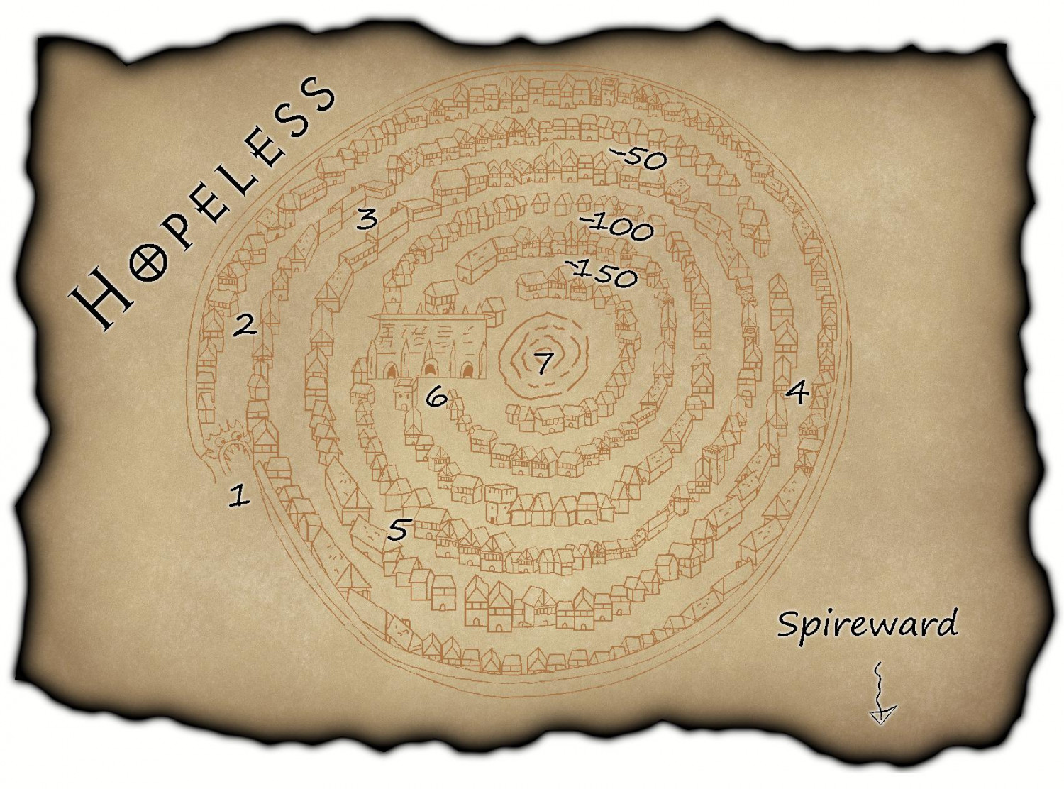
It took me over a month to get to this point mainly because I kept avoiding it. And I kept avoiding it because of the following...
First, I assumed I could simply reuse all the bunch of symbols I'd made for the previous maps, but the issue about the orientations (briefly explained on my previous post) came back to bite me in the... nose. If you've used the John Speed city style, you might have noticed that the symbols are neatly organized and grouped by angle at which they were drawn (0º, 15º, 22º, 30º, 45º, 60º...). And then the symbols grouped inside the collection are the directions where that building is facing. I should have done the same.
Then, I managed to mess up everything about the scales. I've since read Remy's article "Scale Matters" and I wish I'd read it a couple of months ago. Everything in my Symbol Manager (still haven't dared creating a catalog) has a different scale. That means I ended up changing the scale 'by eyeballing' too often. I'm a bit ashamed to admit that it took me too long to realize I had huge houses right in front of tiny buildings. ::sigh::
Believe it or not, I've actually fixed the worst offenders. Too many times I wondered if I should scrap it all and start over. At times it all seemed so Hopeless (yes, I did that on purpose). Actually, John Speed's symbols might be enough -and better- for these maps. But really... I decided to recreate this style to learn. So I kept going.
By the time I determined I didn't really want to keep fixing scaling and orientations ad infinitum, I also realized something more important: I hadn't really learned any new tools or techniques. So I decided to see if I could customize the background. Now, I know there's an Annual issue with much fancier parchments, but I don't own it (yet?). Plus, this venture is all about learning.
The first thing I tried was seeing if I could once again use the Color Key effect and just cut out stuff from the background image, but you can't use Color Key on an inserted raster image. So I removed the picture, created a fill style based on it, and created a new drawing tool. Easy. As I type this, I opened the map and checked if I could use Color Key for this newly created drawing tool, and yes! It does work if do it that way (something with which to tinker later).
Perhaps I should try to add burn marks. If Lillhans can make gorgeous watercolours, surely I can add some stains. Right?
Lessons learned? I could use some planning (I mean, I knew I wanted to make several maps from the beginning). Make sure everything (scale!) is consistent (especially when creating symbols). I shouldn't feel rushed.

-
Forgotten Realms Interactive Atlas repairs.
But I do recall there used to be a pre-1368 map with more details (perhaps one of the updates removed/replaced such map)
Apparently not.
Seems like my memory played tricks on me. At least for the Zhentil Keep map. I dug up my printout and it seems it's the same map as the one in update3 (with the wards layer hidden):
-
Forgotten Realms Interactive Atlas repairs.
I opened the spreadsheet and it had no colours. I'll try on my other laptop.
That's strange. Perhaps you saw the first sheet/tab instead of the one named "roflo1"?
No matter, I have a minor update:
Also...
However, turns out The Board does not allow ODS attachments. So trying XLSX and see?
OpenOffice should allow exporting to XLSX. Google sheets also allows exporting to XLSX.
Speaking of which, I'm now working on Google Sheets so I can edit online from different places. If any of you want live access, please send me a DM.
Anyway, on to the "what's new" section... I wasn't happy about having to inspect visually the differences between 2 maps, but I figured out a way to do it. Basically: a) open in CC3+, b) Info->List->All, c) copy all to clipboard, and d) compare with WinMerge.
It's cumbersome, but precise. I decided to start at the top: with
0030 Temple of Selune.FCW. I discovered update1 is not ok (points to wrong/outdated parent map) so we should use the one from update2 or onwards (I added a "cherry-pick" column to the sheet, where I'll write down which map is the best one to keep when there are multiple versions). While at it, I also discovered thatMoonshae Island.fcwhas the same entities asViledel's Isle.fcw(from upadate2 onward); so links toMoonshae Island.fcwshould be avoided. Finally,Viledel's Isle.fcwfrom update2 has the same entities as the one in update3.
-
Forgotten Realms Interactive Atlas repairs.
Since we can't legally share the maps among us... My guess is, you'd still have to install each update, one at a time. On each stage, you'd have to create a copy of the cherry-picked maps (except now you'd have a list of which to keep on each update), and then copy them back when you're done.
For future installs, if you keep a copy of your cherry-picked folder, you could just jump to update3 and overwrite them.
Best I can come up with so far.
-
Forgotten Realms Interactive Atlas repairs.
Yes, they do open correctly, but the "parent" links to B1cNWlc instead of High Moor.
I.e.: they link to the parent of the parent map.

