


roflo1
roflo1
About
- Username
- roflo1
- Joined
- Visits
- 2,878
- Last Active
- Roles
- Member
- Points
- 576
- Rank
- Surveyor
- Badges
- 8
Latest Images
Reactions
-
Printing maps from PDF?
The croppping/slicing also works. And you can do both things in one go, at least with a new version of ImageMagick:
magick Greengulf_WIP.JPG -crop 800x1100 +repage -units PixelsPerInch -density 100 -page 850x1100 output.pdf
(note that I switched too 100 dpi for this example -because I was being lazy-, so the page size was adjusted accordingly)
And this is the result (I maximized the thumbnail panel and minimized the page display for this screenshot just because it looks better here in the forum).
And all pages are 8.5x11 inches as needed.
EDIT: If you own Annual Issue 129, you should be able to create your own copy of
tile10x10.scrandtile.cmd, and tweak your copies to do everything from within CC3+.
-
Printing maps from PDF?
If you're comfortable with using the terminal/command line, and don't mind having all the pages in a single PDF... I'm honing towards a way to simplify step 3 (especially since CC3 already installs ImageMagick):
convert.exe -units PixelsPerInch -density 300 -page Letter C:\Temp\part* C:\Temp\output.pdf
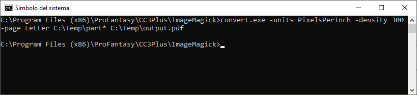
However... it doesn't respect the page size. Maybe with a newer version of ImageMagick?
Sorry if his is half-baked advice, but if I wait to have it fully tested, I might not ever send this. 😅
And apparently, you can also use ImageMagick instead of your step 2. Haven't tried it, but for the newer versions (which use
magick.exeinstead ofconvert.exe) it's something along these lines:magick input.png -crop WxH +repage output%02d.png
(the
%02dpart makes sure all resulting images are numbered using two digits) -
You can get all Profantasy Products for $30
Just for completeness, this Bundle contains:
- Campaign Cartographer 3+ Lifetime License
- Fractal Terrains 3
- Dungeon Designer 3
- City Designer 3
- Cosmographer 3+
- Perspectives 3
- Dioramas 3
- Character Artist 3
- Token Treasury: Monsters 1
- Token Treasury: Monsters 2
- Sources Maps: Castles
- Source Maps: Cities!
- Source Maps: Temples, Tombs and Catacombs
- Tome of Ultimate Mapping
- Symbol Set 1: Fantasy Overland
- Symbol Set 2: Fantasy Floorplans
- Symbol Set 3: Modern
- Symbol Set 4: Dungeons of Schley
- Symbols Set 5: Cities of Schley
- Symbol Set 6: Isometric Cities
- World War 2 Interactive Atlas
- World Builder's Compendium
- Cartographer's Annual Vol 1
- Cartographer's Annual Vol 2
- Cartographer's Annual Vol 3
- Cartographer's Annual Vol 4
- Cartographer's Annual Vol 5
- Cartographer's Annual Vol 6
- Cartographer's Annual Vol 7
- Cartographer's Annual Vol 8
- Cartographer's Annual Vol 9
- Cartographer's Annual Vol 10
- Cartographer's Annual Vol 11
- Cartographer's Annual Vol 12
- Cartographer's Annual Vol 13
- Cartographer's Annual Vol 14
- Cartographer's Annual Vol 15
- Cartographer's Annual Vol 16
- Cartographer's Annual Vol 17


-
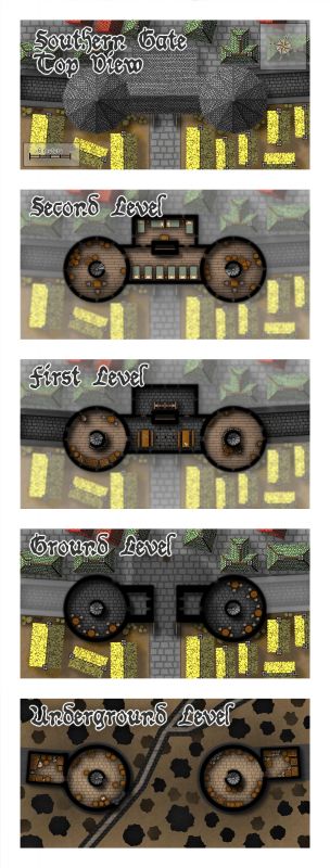
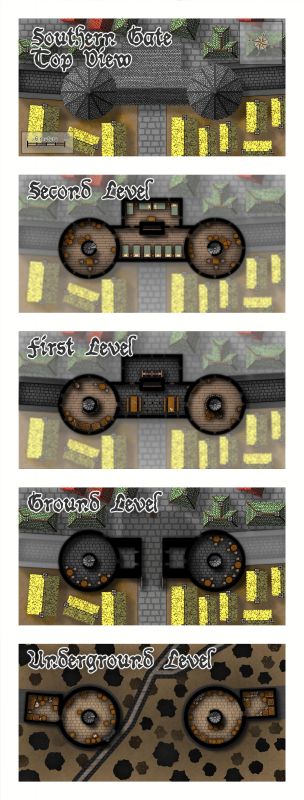
An alternate way to draw elevation changes
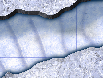
I just bought the 2022 annual and decided to try an Ice Cavern.
When I got to the point where I wanted to draw elevation changes, I went back to watch Ralf's live mapping session. But... I'd added a few effects that were conflicting with Ralf's technique in other places, and I must say I'm not a fan of creating tons of sheets.
But some creative spark ignited and I came up with an alternative. The result is very subtle (because the lack of bevel makes each "step" less pronounced) but I like it a lot. And I can add many many steps without having as many sheets:
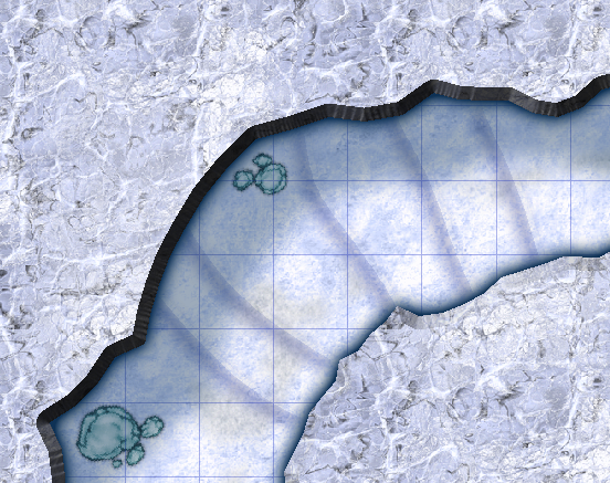
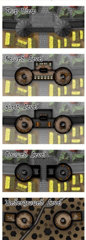
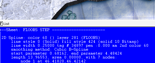
I created a single FLOORS STEP sheet and drew lines with a solid 10 Bitmap (if you hadn't caught it, you might look at the image above and realize it's there... just a faint shade in the top part of each step).
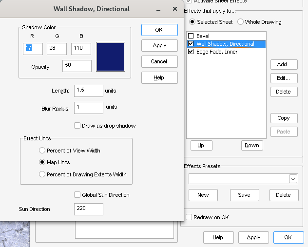
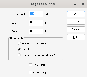
And then just a Wall Shadow, Directional effect, and an Edge Fade, Inner afterwards..
Just for completeness, I tried setting the line to 0-width (the two rightmost in the following image), but the result is even less noticeable (though it might be what you're aiming for):
Of course, given the Sun Direction in my directional wall shadow, these steps only seem logical if going downwards or leftwards, but you can create a new sheet. Two is still a small number. :)
One final note: I had to snap the steps to the nearest point in the cave wall, otherwise I'd get transparency acne (not an issue on the 0-width line).


-
City Designer drawing dimensions
This blog post might also be useful:
It doesn't mention directly sizes, but rather the layouts that resulted.


