


mike robel
mike robel
About
- Username
- mike robel
- Joined
- Visits
- 4,196
- Last Active
- Roles
- Member
- Points
- 435
- Rank
- Surveyor
- Badges
- 6
Latest Images


Reactions
-
"The Most Accurate Flat Map of Earth"/"Astrophysicists Design World Map That Looks Like a Vinyl LP"
Neat stuff.

-
Topographical map of the Ice bed of Antarctica
That's a nice site Jim. Easier, but not so many features as the https://apps.nationalmap.gov/viewer/, but still good. I really like the ability to have the map fill the entire screen.

-
Topographical map of the Ice bed of Antarctica
Hmm. my edit for the correct link didn't work. Here is the correct one: https://opentopomap.org/#map=11/49.9991/9.8383
This should take you to the area near Gemunden, Germany where TF Baum had to leave its planned route to get to Hammelburg on account of a blown bridge.
Another problem I see with importing terrain data, is all the other stuff is left out: roads, cities, bridges, vegetation and so on, so you have to figure out how to put all that onto the map.
Others on the map pointed me to Fractal Terrain which I couldn't get to work and I decided adding the above (augmenting the terrain data) was too difficult, especially trying to align the paper map with the digital data, it was just better to do it manually.
I also found 1:100000 maps to be lacking in detail and so have bought 1:50000 German maps (expensive) or 1:24000 maps (US) and do the tracing thing. USGS offers downloadable PDF maps, which can be stitched together, but the German maps are paper, so one has to scan them in order to manipulate them. Bothersome.

-
After CC3 prompts you to autosave, if you say Yes, does it wipe all Undo memory?
I'm pretty much with Jim: Filename_202103041646 which is the date and time of the phase. 2021 03 04 1646
-
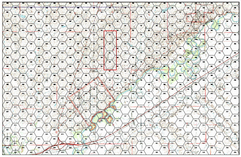
Map Construction
In so far as the grid, I use a hex grid. In this case, I want to have the 1km grid from the map to have 4 hexes inside it, so each one is 250m wide, as shown below. The sizing is arrived at by experimentation and the size is 0.65. The grid is actually a trapazoid and not a square/rectangle, but it is close enough for my work.

-
Ideas for future Annuals
A modern topographical map annual It may be of limited interest, however.
There are elements for this sort of work spread among various templates but a dedicated one would be nice.
Not much is required in drawing tools, but the symbol set could be consolidated and expanded. I know I could construct a custom symbol set drawing them from all the various other sources, but I have had little success with doing this in spite of several attempts.
A custom palette also might be useful concentrating on providing more shading for contours in green (for most environments) and brown/sand (for desert environments). Monson prepared for me a several large pallets of green/brown with 32 and 48 ranges of colors, as well as one that splits the 48 into two between green/brown.
Overhead views of trees and other vegetation would be good as well, allowing one to replace the various symbols with easier on the eyes overhead views of trees for example.

-
New Oxtail - WIP
Tedious is a good word to apply to drawing contour levels.
-
New Map
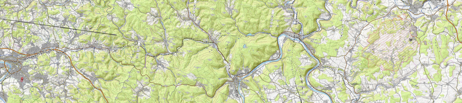
I changed the map so now it will be 12 x 54 inches long and each hex will be about 1 km (at the moment). I also trimmed it and rotated it so N is to the upper right. This improved the resolution so I can see the watercourses better as well as the contours to guide me. Still need to break it up into terrain compartments and decide how to proceed. Aschaffenberg at lower left, Hammelburg at upper right. The actual training area is the slanted red lines. In WWII it was the German Anti-Tank School. The TF had the misfortune to assemble on a tank range so the Germans had very precise ranges from known firing points. When I was there it was the I think it was the Infantry School (84-87).

-
Live Mapping: Contour Shading (Annual Vol 2) CANCELLED TILL NEXT WEEK
I will try to be there for this. Right up my alley and my needs.
-
Huge Archive of Military Maps released
Over 3,000 military maps, views and prints collected by King George III have been digitised and published online free to visit by the Royal Collection.
complete story at the link:
https://www.ianvisits.co.uk/blog/2020/01/29/huge-archive-of-old-military-maps-published/
The site has a cool viewer that really lets you get down into the weed and has information about the map and the mapmakers.
Link to the site: https://militarymaps.rct.uk/
Two examples. Yorktown. Another place I have GOT to get to. My two attempts were frustrated by personal issues.
And then one of London.
Be prepared to lose some time.
