


Wyvern
Wyvern
About
- Username
- Wyvern
- Joined
- Visits
- 3,267
- Last Active
- Roles
- Member
- Points
- 5,585
- Rank
- Cartographer
- Badges
- 24
Latest Images


-
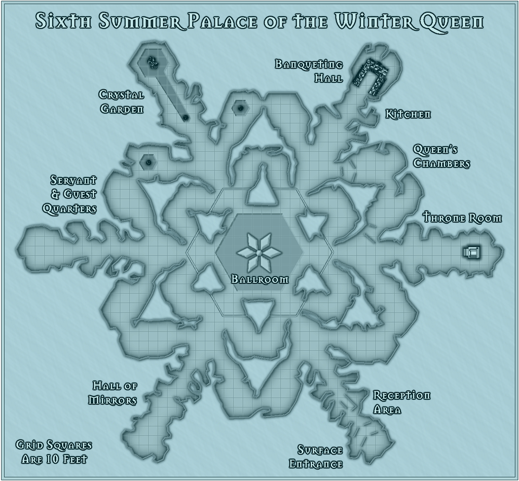
Community Atlas competition entry: The Summer Palace of the Winter Queen
Palace 6 (that's over halfway!) is another black-and-white map, using the CA48 Black & White Dungeons style. This time, I chanced using a few of the symbols that come with the style, mostly because I liked the throne, and didn't want to just have that one symbol on its own. So we have actual fountains in the Crystal Garden for once, and a set banqueting table, with seats, for the Banqueting Hall (not the clearest in this low-res image, I appreciate). I also did a little more decoration for the floor of the huge central Ballroom, primarily because the forms were on the original snowflake image, and I thought the floral design especially worked well with the overall concept of the Summer Palace idea. Plus that outer large hexagonal line forms a neat border to the Ballroom itself. As last time, the first map is the B&W version, the second one where I've added some blue iciness, this time in the form of a simple blue coloured covering rectangle with a strong Transparency Effect on it. Again, if all goes to plan, this should be available via a toggle in the Atlas version.
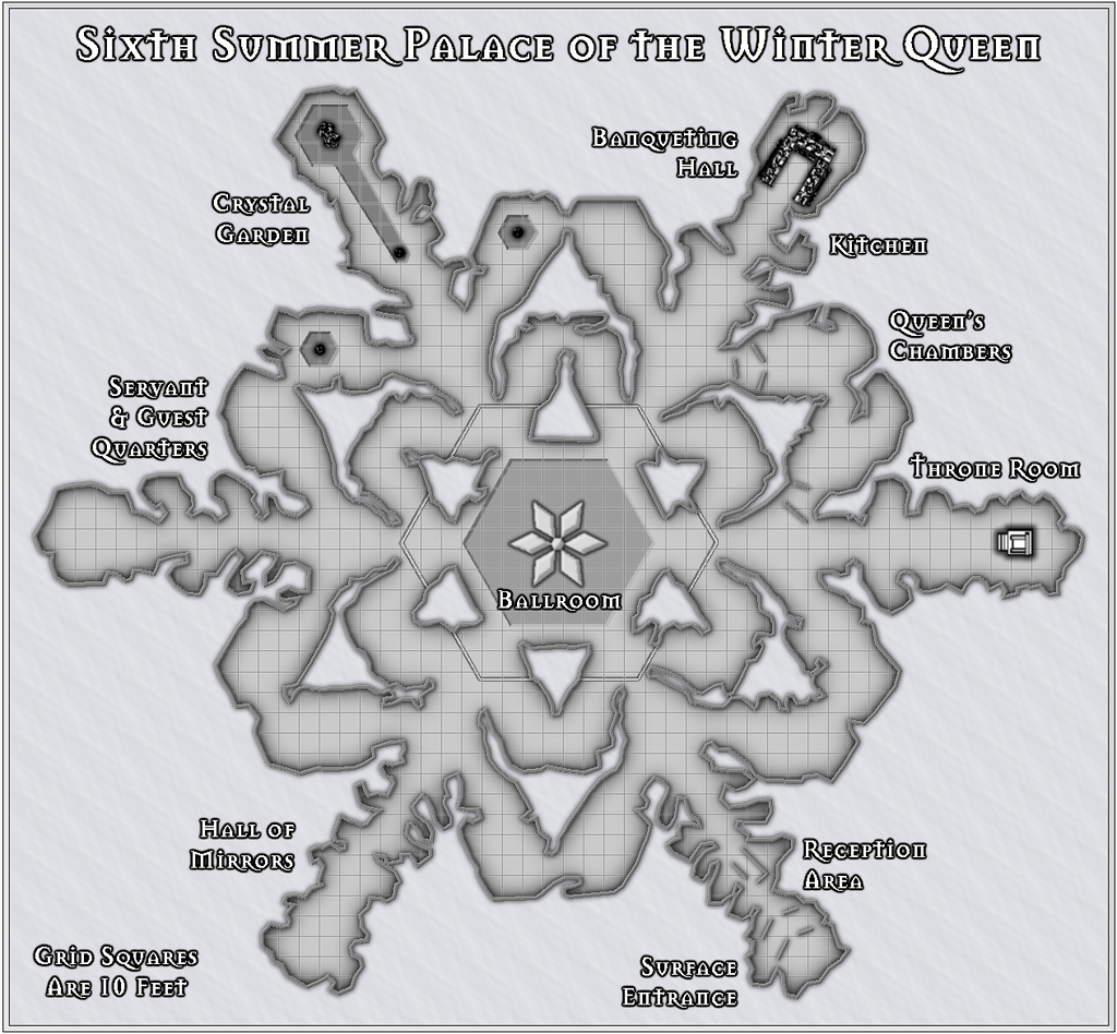
Whereas Palace 5 used a simple drawn polygon for the floor outline, with the internal wall-blocks on that drawn and set up using walls and floor masks on Sheets above the floor one, here, the floor was done as a multipoly, after drawing in the internal walls first, and copying them to the floor sheet before carrying out the command. And treble-checking I wasn't going to need to do more with it later, given you can't adjust nodes on a multipoly later!
Despite which, if you check very hard in the FCW file, you will find one spot where I had to add a new floor patch because one of the walls had grown just a bit too spiky... Isn't it always the way?


-
Grimdark Fantasy (renamed "Darklands") - development thread
@Loopysue - The compass indicators seem too perfect currently. The human skull should maybe have at least some damaged, worn or missing teeth, and likely be a bit more battered overall - Grimdark, not Clean & Neat, after all! Similarly the other skull (dragon?) could be a bit more battered as well, perhaps.
If the FaceBook group wants something a bit "nastier", you might go for an entire impaled skeleton (or being mischievous, you might imagine it to be some of the more vocal respondents there ?), or possibly a severed head hanging from a gibbet, as that seems both grimmer and darker in general...
![[Deleted User]](https://secure.gravatar.com/avatar/c75d9a245b74d9c59be0999ea81ca541/?default=https%3A%2F%2Fvanillicon.com%2F92add7f8c954488718110edc4896ad39_200.png&rating=g&size=200)
-
Desert map for a commission
Sorry Quenten, I'm not sure there's enough information here to make detailed real-world comparisons with to suggest possible sea currents and prevailing winds.
The fairly narrow global belts of desert right across both northern and southern hemispheres suggests there's something odd happening generally, given the vast expanse of oceans here, which in many places are a lot deeper over vaster areas than Earth's (scarcely any part of Earth's oceans are deeper than 8,000 metres, for instance). That should suggest there'd be plenty of water available for rainfall everywhere, especially on any near-coastal areas where the prevailing winds are onshore. If the planet rotates in the same direction as Earth, that should imply west-facing coasts would be more likely to see higher rainfall tallies, but it looks as if it's more the east-facing ones that are somewhat favoured by this (albeit dependent on the prevailing winds, however).
Aside from the rotation issue, it might be useful to add some latitude lines, such as for whatever latitudes the tropics are at, the equator and polar circles, for example, and also some indication as to what parameters were used to generate the climate regimes (albeit with the latter, you could probably work out for yourself what the more likely prevailing winds at least might be).
-
Desert map for a commission
To be honest, the extra water depth across these oceans makes direct comparisons with Earth a lot more difficult, as Earth has never had oceans so deep. Thus setting-up the winds and currents to fit the terrain better is probably no bad thing, as it would be possible to counter-argue just about any points that might be claimed as too unlike Earth.

-
Scale issues with a metric map
...Thank you France for 'inventing' the metric system.
Well, technically, it was a Scot, James Watt, who advocated a standardised international decimal system of scientific measurements in 1783, and what we now recognise as the whole series of SI units, sometimes colloquially referred to as the "metric system", was the product of a great many people in various parts of the world over many years from the 18th to 20th centuries, with numerous variant definitions even for the metre during that time. What's now considered that metric system, the formal international adoption of the SI units in fact, didn't happen until 1960, and that Système International continues to evolve.
Sadly, there isn't a suitable metric definition for such pedantry though ??

-
[WIP] Atlas Competition Entry - Coils of the Cold Coroner
Does it actually matter? It gives me the impression that the blocky ice of the more northerly area continues in places through the hills and mountains, but only by straining quite hard at the image. Gives a feeling that something's not quite what it seems as well, perhaps.
However, I suspect Monsen's right, that the opacity of the fills simply needs adjusting upwards to resolve!
-
The 'NoDucks' version 3
I think "chook" originated with some dialects of English. "Chuck" is a term of endearment still used in parts of northern England, for instance, which derives from the same source, as a variant on "chick" as an abbreviation for "chicken", or from "chick" as being a young chicken. Online sources seem to cover only the modern Australian option as in-use still, however.
And here was me thinking "duck down" was an urgent warning...
-
Sandpoint Town Hall
All this AND a Golden Wyvern too! What more could one ask?! ?

-
Desert map for a commission
The extra water depth complicates matters for the ocean currents aside from surface weather patterns, mostly because we don't really understand how deep ocean currents work on Earth, so for a situation like this, it becomes - whatever you like, more or less!
-
Grimdark Fantasy (renamed "Darklands") - development thread
I want to say "looking good", but I'm not sure that's an appropriate comment, even if the sentiment's right ?
